

Acta Geodaetica et Cartographica Sinica ›› 2025, Vol. 54 ›› Issue (5): 785-794.doi: 10.11947/j.AGCS.2025.20240120
• Digital Twin • Previous Articles Next Articles
Biao HE1,2,3,4( ), Renzhong GUO1,2,3,4(), Hai XU1,2,3,4, Xi KUAI1,2,3,4, Haojia LIN1,2,3,4, Zhigang ZHAO1,2,3,4
Received:2024-03-08
Revised:2025-01-22
Online:2025-06-23
Published:2025-06-23
Contact:
Renzhong GUO
E-mail:hebiao@szu.edu.cn;guorz@szu.edu.cn
About author:HE Biao (1983—), male, PhD, professor, majors in smart city digital twin platform, 3D cadastral, et al. E-mail: hebiao@szu.edu.cn
Supported by:CLC Number:
Biao HE, Renzhong GUO, Hai XU, Xi KUAI, Haojia LIN, Zhigang ZHAO. Concept and technical system of smart city operating system[J]. Acta Geodaetica et Cartographica Sinica, 2025, 54(5): 785-794.
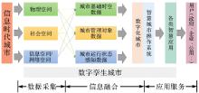
Fig. 1
Relationship between information city, ternary space, and smart city operating system"
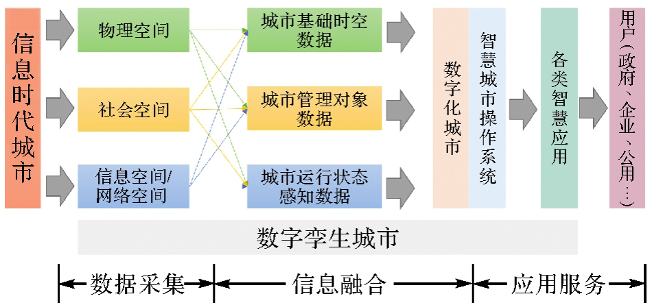
Fig. 2
Analogy between smart city operating system and computer operating system"
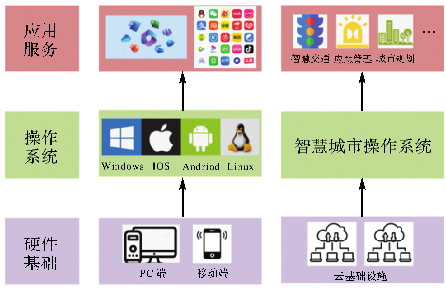
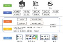
Fig. 3
Logical layering of smart city"
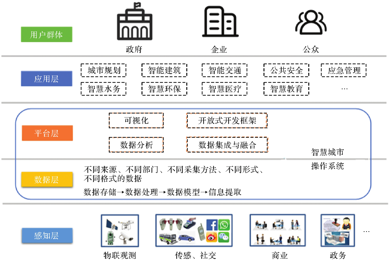
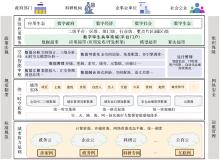
Fig. 4
Framework of smart city operating system"

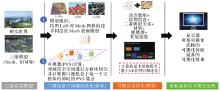
Fig. 5
Highly realistic and smooth visualization framework for large scenes by integrating game engine and GIS"

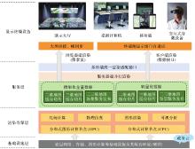
Fig. 6
Cross-platform multi-terminal 3D visualization engine framework"

| [1] | GIBSON D V, KOZMETSKY G, SMILOR R W. The technopolis phenomenon: smart cities, fast systems, global networks[M]. Washington DC: Rowman & Littlefield, 1992. |
| [2] | CARAGLIU A, DEL BO C, NIJKAMP P. Smart cities in Europe[J]. Journal of Urban Technology, 2011, 18(2): 65-82. |
| [3] | CLARISSE P. Smart cities in Japan: an assessment on the potential for EU-Japan cooperation and business development[R]. Tokyo: The EU-Japan Center, 2014. |
| [4] | NGP T. Embracing emerging technologies: the case of the Singapore intelligent nation 2015 vision[M]//Regional innovation systems and sustainable development. Emerging Technologies: IGI Global, 2011. |
| [5] | PASKALEVA K A. Enabling the smart city: the progress of city e-governance in Europe[J]. International Journal of Innovation and Regional Development, 2009, 1(4): 405-422. |
| [6] | BRONSTEIN Z. Industry and the smart cities[J]. Dissent, 2009, 56(3): 27-34. |
| [7] | LIU Pu, PENG Zhenghong. China's smart city pilots: a progress report[J]. Computer, 2014, 47(10): 72-81. |
| [8] | PAN Yunhe. Heading toward artificial intelligence 2.0[J]. Engineering, 2016, 2(4): 51-61. |
| [9] | 郭仁忠, 林浩嘉, 贺彪, 等. 面向智慧城市的GIS框架[J]. 武汉大学学报(信息科学版), 2020, 45(12): 1829-1835. |
| GUO Renzhong, LIN Haojia, HE Biao, et al. GIS framework for smart cities[J]. Geomatics and Information Science of Wuhan University, 2020, 45(12): 1829-1835. | |
| [10] | ZANELLA A, BUI N, CASTELLANI A, et al. Internet of things for smart cities[J]. IEEE Internet of Things Journal, 2014, 1(1): 22-32. |
| [11] | 周干峙. 城市及其区域:一个典型的开放的复杂巨系统[J]. 城市规划, 2002, 26(2): 7-8, 18. |
| ZHOU Ganzhi. City and its region: an typical open complex huge system[J]. City Planning Review, 2002, 26(2): 7-8, 18. | |
| [12] | RUHLANDT R W S. The governance of smart cities: a systematic literature review[J]. Cities, 2018, 81: 1-23. |
| [13] | 王家耀, 刘嵘, 成毅, 等. 让城市更智慧[J]. 测绘科学技术学报, 2011, 28(2): 79-83. |
| WANG Jiayao, LIU Rong, CHENG Yi, et al. Making the city smarter[J]. Journal of Geomatics Science and Technology, 2011, 28(2): 79-83. | |
| [14] | 郭仁忠, 张双虎. 智慧城市该如何建[N]. 中国科学报, 2020-10-22(3). |
| GUO Renzhong, ZHANG Shuanghu. How to build a smart city[N]. China Science Daily, 2020-10-22(3). | |
| [15] | 李德仁, 姚远, 邵振峰. 智慧城市中的大数据[J]. 武汉大学学报(信息科学版), 2014, 39(6): 631-640. |
| LI Deren, YAO Yuan, SHAO Zhenfeng. Big data in smart city[J]. Geomatics and Information Science of Wuhan University, 2014, 39(6): 631-640. | |
| [16] |
龚健雅, 张翔, 向隆刚, 等. 智慧城市综合感知与智能决策的进展及应用[J]. 测绘学报, 2019, 48(12): 1482-1497. DOI: .
doi: 10.11947/j.AGCS.2019.20190464 |
|
GONG Jianya, ZHANG Xiang, XIANG Longgang, et al. Progress and applications for integrated sensing and intelligent decision in smart city[J]. Acta Geodaetica et Cartographica Sinica, 2019, 48(12): 1482-1497. DOI: .
doi: 10.11947/j.AGCS.2019.20190464 |
|
| [17] | 李德仁, 龚健雅, 邵振峰. 从数字地球到智慧地球[J]. 武汉大学学报(信息科学版), 2010, 35(2): 127-132, 253-254. |
| LI Deren, GONG Jianya, SHAO Zhenfeng. From digital Earth to smart Earth[J]. Geomatics and Information Science of Wuhan University, 2010, 35(2): 127-132, 253-254. | |
| [18] | 郑宇. 城市计算概述[J]. 武汉大学学报(信息科学版), 2015, 40(1): 1-13. |
| ZHENG Yu. Introduction to urban computing[J]. Geomatics and Information Science of Wuhan University, 2015, 40(1): 1-13. | |
| [19] |
杨元喜, 王建荣. 泛在感知与航天测绘[J]. 测绘学报, 2023, 52(1): 1-7. DOI: .
doi: 10.11947/j.AGCS.2023.20220405 |
|
YANG Yuanxi, WANG Jianrong. Ubiquitous perception and space mapping[J]. Acta Geodaetica et Cartographica Sinica, 2023, 52(1): 1-7. DOI: .
doi: 10.11947/j.AGCS.2023.20220405 |
|
| [20] |
刘经南, 郭文飞, 郭迟, 等. 智能时代泛在测绘的再思考[J]. 测绘学报, 2020, 49(4): 403-414. DOI: .
doi: 10.11947/j.AGCS.2020.20190539 |
|
LIU Jingnan, GUO Wenfei, GUO Chi, et al. Rethinking ubiquitous mapping in the intelligent age[J]. Acta Geodaetica et Cartographica Sinica, 2020, 49(4): 403-414. DOI: .
doi: 10.11947/j.AGCS.2020.20190539 |
|
| [21] | 李德仁, 张良培, 夏桂松. 遥感大数据自动分析与数据挖掘[J]. 测绘学报, 2014, 43(12): 1211-1216. |
| LI Deren, ZHANG Liangpei, XIA Guisong. Automatic analysis and mining of remote sensing big data[J]. Acta Geodaetica et Cartographica Sinica, 2014, 43(12): 1211-1216. | |
| [22] |
单杰, 李志鑫, 张文元. 大规模三维城市建模进展[J]. 测绘学报, 2019, 48(12): 1523-1541. DOI: .
doi: 10.11947/j.AGCS.2019.20190471 |
|
SHAN Jie, LI Zhixin, ZHANG Wenyuan. Recent progress in large-scale 3D city modeling[J]. Acta Geodaetica et Cartographica Sinica, 2019, 48(12): 1523-1541. DOI: .
doi: 10.11947/j.AGCS.2019.20190471 |
|
| [23] |
朱庆, 张利国, 丁雨淋, 等. 从实景三维建模到数字孪生建模[J]. 测绘学报, 2022, 51(6): 1040-1049. DOI: .
doi: 10.11947/j.AGCS.2022.20210640 |
|
ZHU Qing, ZHANG Liguo, DING Yulin, et al. From real 3D modeling to digital twin modeling[J]. Acta Geodaetica et Cartographica Sinica, 2022, 51(6): 1040-1049. DOI: .
doi: 10.11947/j.AGCS.2022.20210640 |
|
| [24] |
林珲, 朱庆, 陈旻. 有无相生 虚实互济:虚拟地理环境研究20周年综述[J]. 测绘学报, 2018, 47(8): 1027-1030. DOI: .
doi: 10.11947/j.AGCS.2018.20180202 |
|
LIN Hui, ZHU Qing, CHEN Min. The being and non-being generate each other, and the virtual and the real are mutually interactive: the progress of virtual geographic environments (VGE) studies in last 20 years[J]. Acta Geodaetica et Cartographica Sinica, 2018, 47(8): 1027-1030. DOI: .
doi: 10.11947/j.AGCS.2018.20180202 |
|
| [25] | 贺彪, 郭仁忠, 张琛, 等. 面向数字孪生城市的自然场景构造方法[J]. 测绘通报, 2022(7): 87-92. |
| HE Biao, GUO Renzhong, ZHANG Chen, et al. A natural scene construction method for digital twin cities[J]. Bulletin of Surveying and Mapping, 2022(7): 87-92. | |
| [26] | XU Hai, HE Biao, ZHANG Chen, et al. Quality-preserving multilevel mesh generation for building models[J]. International Journal of Digital Earth, 2024, 17(1): 201-208. |
| [27] |
陈军, 武昊, 刘万增, 等. 自然资源时空信息的技术内涵与研究方向[J]. 测绘学报, 2022, 51(7): 1130-1140. DOI: .
doi: 10.11947/j.AGCS.2022.20210643 |
|
CHEN Jun, WU Hao, LIU Wanzeng, et al. Technical connotation and research agenda of natural resources spatio-temporal information[J]. Acta Geodaetica et Cartographica Sinica, 2022, 51(7): 1130-1140. DOI: .
doi: 10.11947/j.AGCS.2022.20210643 |
|
| [28] |
郭仁忠, 陈业滨, 马丁, 等. 论ICT时代的泛地图表达[J]. 测绘学报, 2022, 51(7): 1108-1113. DOI: .
doi: 10.11947/j.AGCS.2022.20220140 |
|
GUO Renzhong, CHEN Yebin, MA Ding, et al. Pan-map representation in ICT era[J]. Acta Geodaetica et Cartographica Sinica, 2022, 51(7): 1108-1113. DOI: .
doi: 10.11947/j.AGCS.2022.20220140 |
|
| [29] | 徐海, 贺彪, 蒯希, 等. 融合分层层次细节和潜在可见集的三维城市场景高效可视化[J]. 测绘通报, 2024(1): 102-108. |
| XU Hai, HE Biao, KUAI Xi, et al. Efficient visualization of 3D city scenes combining hierarchical level of details and potential visible sets[J]. Bulletin of Surveying and Mapping, 2024(1): 102-108. | |
| [30] | 朱庆. 三维GIS及其在智慧城市中的应用[J]. 地球信息科学学报, 2014, 16(2): 151-157. |
| ZHU Qing. Full three-dimensional GIS and its key roles in smart city[J]. Journal of Geo-information Science, 2014, 16(2): 151-157. | |
| [31] | 于施洋, 郭明军, 郭巧敏, 等. 数字城市“新市政”:城市算力网的总体架构及实施路径研究[J]. 电子政务, 2022(12): 2-12. |
| YU Shiyang, GUO Mingjun, GUO Qiaomin, et al. “New municipal administration” of digital city: research on the overall framework and implementation path of urban computing network[J]. E-Government, 2022(12): 2-12. | |
| [32] | 张新长, 廖曦, 阮永俭. 智慧城市建设中的数字孪生与元宇宙探讨[J]. 测绘通报, 2023(1): 1-7, 13. |
| ZHANG Xinchang, LIAO Xi, RUAN Yongjian. Discussion on digital twin and metaverse in smart city construction[J]. Bulletin of Surveying and Mapping, 2023(1): 1-7, 13. | |
| [33] | DEMBSKI F, WÖSSNER U, LETZGUS M, et al. Urban digital twins for smart cities and citizens: the case study of Herrenberg, Germany[J]. Sustainability, 2020, 12(6): 2307. |
| [1] | Biao HE, Haojia LIN, Renzhong GUO, Xi KUAI, Ding MA, Chen ZHANG. Visual perception-based quantitative calculation of 3D spatial similarity relations [J]. Acta Geodaetica et Cartographica Sinica, 2026, 55(1): 138-153. |
| [2] | Renzhong GUO, Biao HE, Zhigang ZHAO, Xiaoming LI, Xi KUAI, Haojia LIN, Yebin CHEN, Ding MA. Smart city logical framework and digital-twin platform technical requirements [J]. Acta Geodaetica et Cartographica Sinica, 2025, 54(5): 777-784. |
| [3] | Huayi WU, Zhangxiao SHEN, Shuyang HOU, Jianyuan LIANG, Anqi ZHAO, Haoyue JIAO, Zhipeng GUI, Xuefeng GUAN. Large language model-driven GIS analysis: methods, applications, and prospects [J]. Acta Geodaetica et Cartographica Sinica, 2025, 54(4): 621-635. |
| [4] | Xing ZHANG, Zhanpeng HUANG, Qingquan LI, Baoding ZHOU, Qipei LI. 3D tunnel mapping method combining registration compensation and spatial constraint [J]. Acta Geodaetica et Cartographica Sinica, 2025, 54(2): 297-307. |
| [5] | Shanshan WANG, Junfu FAN, Zhikun ZHANG, Jianyun HAN. CPU-GPU hybrid parallel overlay analysis method for GIS vector polygons based on improved Vatti algorithm using even-odd sorting [J]. Acta Geodaetica et Cartographica Sinica, 2025, 54(2): 345-355. |
| [6] | Deren LI, Mi WANG, Wenbin SHEN, Qingyun DU, Shuo WANG. On the development of surveying and mapping in the era of artificial intelligence [J]. Acta Geodaetica et Cartographica Sinica, 2025, 54(12): 2107-2115. |
| [7] | Yongjun ZHANG, Changjun ZHU, Siyuan ZOU, Xinyi LIU, Qingzhou MAO, Yi WAN. Registration of aerial images and LiDAR point clouds based on distance field and plane constraints [J]. Acta Geodaetica et Cartographica Sinica, 2025, 54(1): 64-74. |
| [8] | XIANG Deliang, DING Huaiyue, GUAN Dongdong, CHENG Jianda, SUN Xiaokun. PolSAR image registration combining polarization whitening filtering and SimSD-CapsuleNet [J]. Acta Geodaetica et Cartographica Sinica, 2024, 53(3): 450-462. |
| [9] | CHEN Shuai, MIAO Zelang, WU Lixin. Probabilistic seismic landslide hazard mapping with consideration of slope occurrence environment [J]. Acta Geodaetica et Cartographica Sinica, 2023, 52(9): 1548-1561. |
| [10] | Lü Kefeng, ZHANG Yongsheng, YU Ying, MIN Jie. Instance object localization based on semantic information and geo-registration [J]. Acta Geodaetica et Cartographica Sinica, 2023, 52(8): 1375-1386. |
| [11] | ZHANG Guangyun, HAN Yi, ZHANG Rongting, LI Mingfeng, JI Wenlai. A spatial consistency-based point cloud registration method for the same platform [J]. Acta Geodaetica et Cartographica Sinica, 2023, 52(5): 789-797. |
| [12] | LI Haoran, MEI Tiancan, GAO Zhi. 3D face reconstruction based on global ICP and improved Poisson [J]. Acta Geodaetica et Cartographica Sinica, 2023, 52(3): 454-463. |
| [13] | ZHANG Yongxian, MA Guorui, ZI Shuanjin, MEN Hang. Multi-source remote sensing image bidirectional consistent registration based on learning feature [J]. Acta Geodaetica et Cartographica Sinica, 2023, 52(11): 1906-1916. |
| [14] | LI Jiayuan, ZHANG Yongjun, AI Mingyao, HU Qingwu. Scale-adaptive Cauchy robust estimation based on progressive optimization and its applications [J]. Acta Geodaetica et Cartographica Sinica, 2023, 52(1): 61-70. |
| [15] | ZHANG Ning, JIN Shaohua, BIAN Gang, XIAO Fumin. An iterative and adaptive registration method for multi-beam and side-scan sonar images [J]. Acta Geodaetica et Cartographica Sinica, 2022, 51(9): 1951-1958. |
| Viewed | ||||||
|
Full text |
|
|||||
|
Abstract |
|
|||||