

Acta Geodaetica et Cartographica Sinica ›› 2025, Vol. 54 ›› Issue (6): 1009-1020.doi: 10.11947/j.AGCS.2025.20240426
• Geodesy and Navigation • Previous Articles Next Articles
Kefu WU1( ), Haiqiang FU1(), Jianjun ZHU1, Qijin HAN2, Aichun WANG2, Mingxia ZHANG2, Zhiwei LI1
Received:2024-10-16
Revised:2025-05-14
Online:2025-07-14
Published:2025-07-14
Contact:
Haiqiang FU
E-mail:kefuwu@csu.edu.cn;haiqiangfu@csu.edu.cn
About author:WU Kefu (2000—), male, PhD candidate, majors in InSAR topographic mapping and regional network adjustment. E-mail: kefuwu@csu.edu.cn
Supported by:CLC Number:
Kefu WU, Haiqiang FU, Jianjun ZHU, Qijin HAN, Aichun WANG, Mingxia ZHANG, Zhiwei LI. LT-1 InSAR block adjustment considering the impact of penetration depth in forest areas[J]. Acta Geodaetica et Cartographica Sinica, 2025, 54(6): 1009-1020.
Fig. 1
The frame of InSAR block adjustment considering the impact of penetration depth in forest areas"
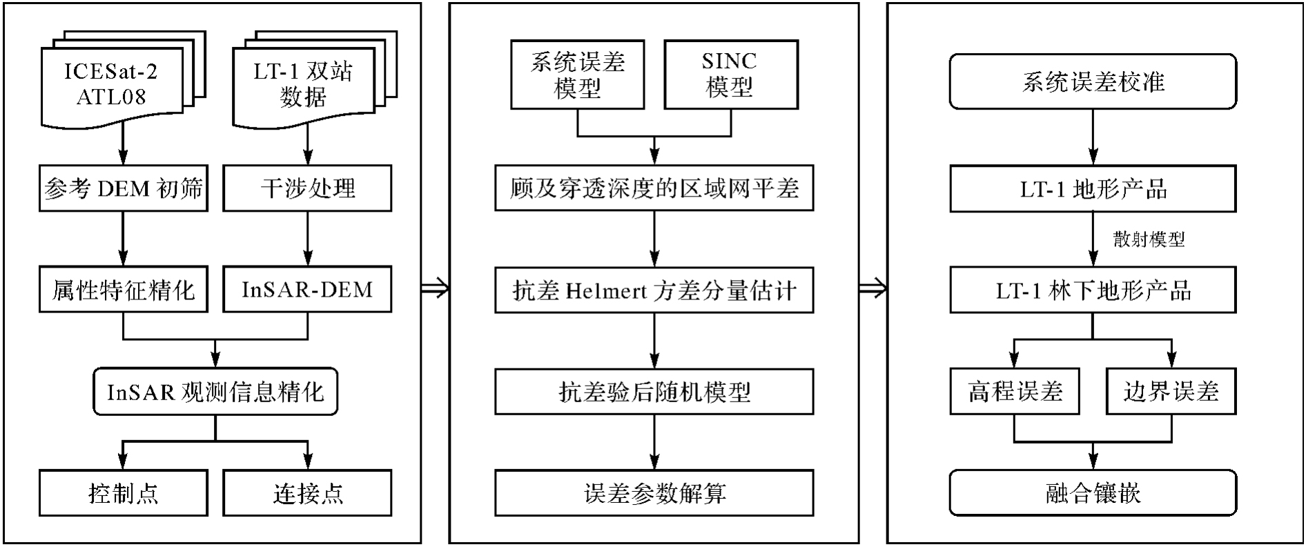
Fig. 2
The configuration of LT-1 data"

Tab. 1
The selection criteria for GCPs and TPs"
| 数据集 | 数据来源 | 筛选法则 |
|---|---|---|
| 控制点 | ICESat-2 ATL08 | 1. 利用COP-DEM剔除粗差 |
| 2. 强波束 | ||
| 3. 云量小于20% | ||
| 4. 非InSAR几何畸变区 | ||
| 5. InSAR相干性大于第60百分位数 | ||
| 6. 与LT-1 DEM差分相互剔除粗差 | ||
| 连接点 | InSAR DEM | 1. 坡度小于30° |
| 2. 非InSAR几何畸变区 | ||
| 3. InSAR相干性大于第60百分位数 | ||
| 4. 连接点对差分相互剔除粗差 |
Tab. 2
The parameters of FNF and global DEM products"
| 数据集 | 发布年份 | 水平基准 | 垂直基准 | 分辨率/m |
|---|---|---|---|---|
| COP-DEM | 2020 | WGS-84 | EGM2008 | 30 |
| SRTM V3 | 2013 | WGS-84 | EGM96 | 30 |
| AW3D V2.2 | 2019 | GRS80 | EGM96 | 30 |
| FNF | 2019 | WGS-84 | — | 50 |
Fig. 3
The results of test site 1"
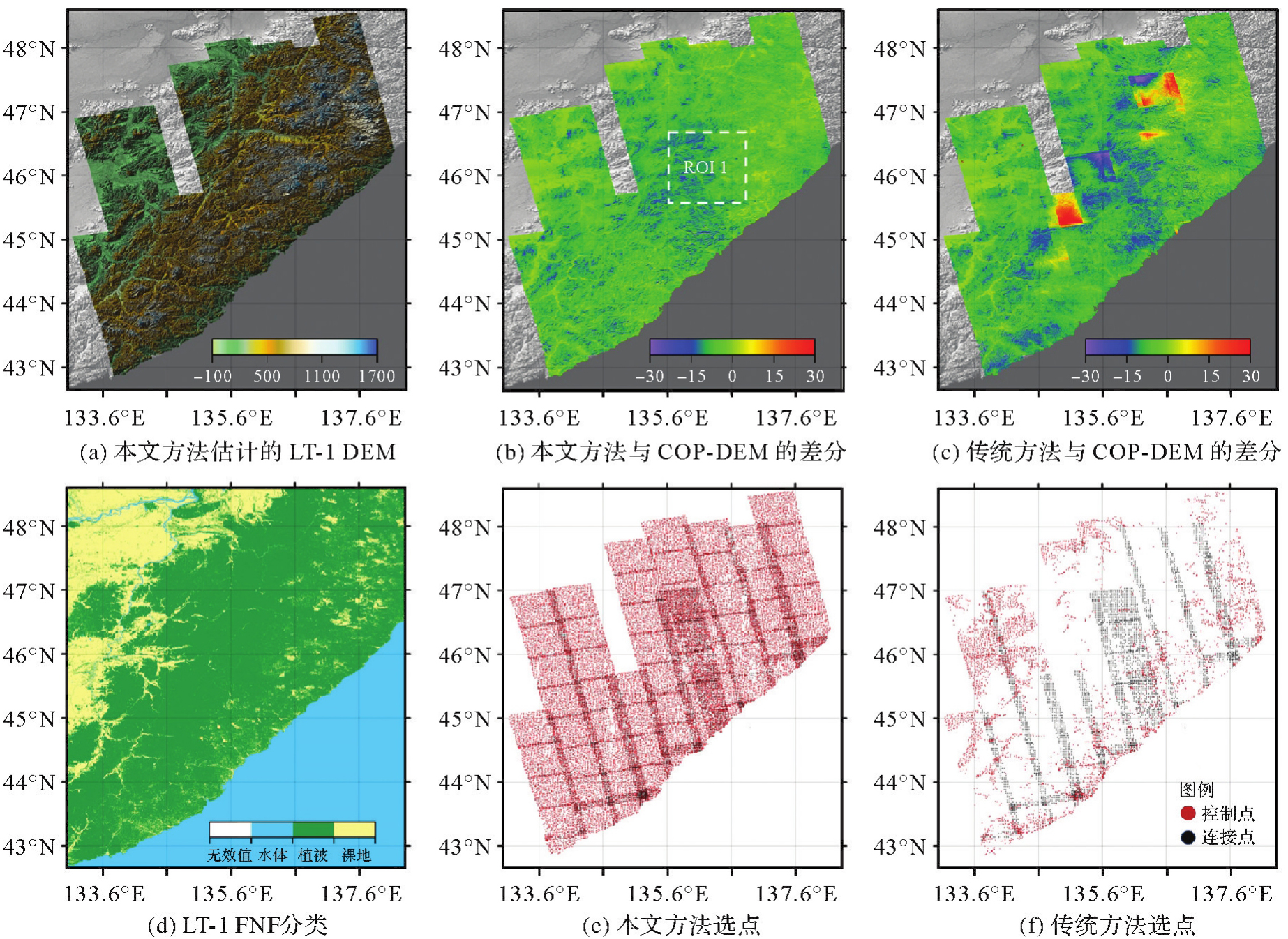
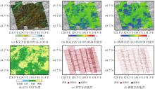
Fig. 4
The results of test site 2"

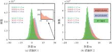
Fig. 5
Height accuracy statistics"

Tab. 3
Comparison of terrain accuracy under different slopes in test site 1"
| 地形产品 | (0°,5°] | (5°,10°] | (10°,15°] | (15°,20°] | (20°,90°] | |||||
|---|---|---|---|---|---|---|---|---|---|---|
| RMSE | MAE | RMSE | MAE | RMSE | MAE | RMSE | MAE | RMSE | MAE | |
| LT-1 DEM | 4.39 | 3.47 | 4.96 | 4.11 | 5.50 | 4.56 | 6.24 | 5.19 | 7.25 | 5.99 |
| 林下地形 | 2.26 | 1.70 | 2.79 | 2.13 | 3.41 | 2.63 | 4.20 | 3.24 | 5.45 | 4.20 |
| COP-DEM | 9.01 | 7.53 | 10.46 | 9.41 | 11.26 | 10.21 | 12.16 | 11.00 | 13.06 | 11.51 |
| SRTM | 5.40 | 4.39 | 6.48 | 5.51 | 7.54 | 6.44 | 8.84 | 7.49 | 10.43 | 8.68 |
| AW3D | 6.20 | 5.15 | 7.27 | 6.28 | 8.00 | 6.78 | 8.40 | 6.93 | 9.70 | 7.72 |
Tab. 4
Comparison of terrain accuracy under different slopes in test site 2"
| 地形产品 | (0°,5°] | (5°,10°] | (10°,15°] | (15°,20°] | (20°,90°] | |||||
|---|---|---|---|---|---|---|---|---|---|---|
| RMSE | MAE | RMSE | MAE | RMSE | MAE | RMSE | MAE | RMSE | MAE | |
| LT-1 DEM | 2.31 | 1.56 | 3.13 | 2.32 | 4.00 | 3.07 | 5.15 | 4.05 | 6.67 | 5.30 |
| 林下地形 | 1.84 | 1.28 | 2.40 | 1.77 | 3.09 | 2.30 | 4.06 | 3.05 | 5.54 | 4.17 |
| COP-DEM | 4.91 | 3.28 | 6.68 | 5.21 | 7.83 | 6.42 | 9.10 | 7.59 | 10.53 | 8.84 |
| SRTM | 3.12 | 2.39 | 3.99 | 3.11 | 4.82 | 3.78 | 5.96 | 4.71 | 7.59 | 6.17 |
| AW3D | 3.83 | 2.88 | 5.14 | 4.06 | 6.23 | 4.97 | 7.08 | 5.56 | 9.32 | 7.22 |
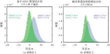
Fig. 6
Height matching comparison between InSAR and LiDAR in forest areas"
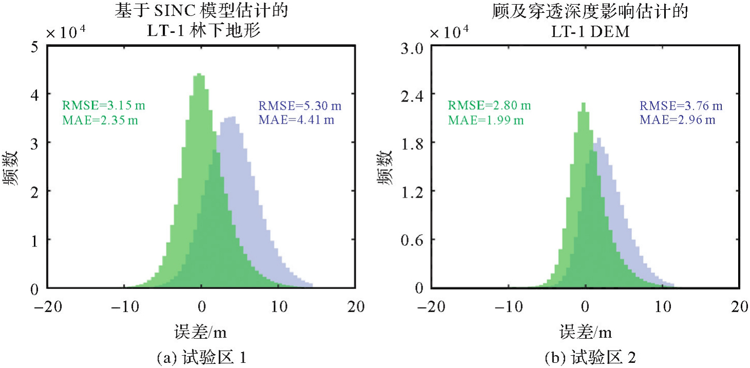
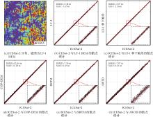
Fig. 7
Visual analysis of forest penetration in different bands of ROI 1"

Tab. 5
Forest penetration rate of different terrain products at different slopes"
| 试验区 | 地形产品 | (0°,5°] | (5°,10°] | (10°,15°] | (15°,20°] | (20°,90°] |
|---|---|---|---|---|---|---|
| 1 | LT-1 DEM | 75.6 | 75.6 | 76.5 | 76.5 | 76.0 |
| LT-1林下地形 | 99.2 | 99.1 | 99.4 | 100.5 | 100.6 | |
| COP DEM | 51.7 | 52.0 | 48.9 | 50.9 | 51.6 | |
| SRTM | 68.4 | 68.2 | 67.5 | 61.5 | 58.9 | |
| AW3D | 67.8 | 67.6 | 66.7 | 64.7 | 63.2 | |
| 2 | LT-1 DEM | 77.4 | 77.8 | 76.3 | 74.2 | 76.7 |
| LT-1林下地形 | 99.5 | 99.0 | 98.9 | 99.7 | 100.2 | |
| COP DEM | 54.9 | 57.0 | 54.3 | 48.2 | 47.6 | |
| SRTM | 70.8 | 71.9 | 72.8 | 72.9 | 70.3 | |
| AW3D | 63.9 | 65.5 | 65.5 | 66.0 | 64.4 |
Tab. 6
The fitting accuracy of SINC model under different forest types"
| 试验区 | 森林类型 | RMSE/m | MAE/m | 检核点数 |
|---|---|---|---|---|
| 1 | 落叶阔叶林 | 2.61 | 2.00 | 135217 |
| 常绿针叶林 | 2.69 | 2.09 | 49508 | |
| 落叶针叶林 | 2.47 | 1.91 | 37962 | |
| 2 | 落叶阔叶林 | 2.29 | 1.62 | 79289 |
| 常绿针叶林 | 2.73 | 2.02 | 2725 | |
| 落叶针叶林 | 2.33 | 1.68 | 7311 |
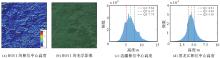
Fig. 8
Phase center height fitted by the SINC model"

| [1] | 朱建军, 付海强, 汪长城. InSAR林下地形测绘方法与研究进展[J]. 武汉大学学报(信息科学版), 2018, 43(12): 2030-2038. |
| ZHU Jianjun, FU Haiqiang, WANG Changcheng. Methods and research progress of underlying topography estimation over forest areas by InSAR[J]. Geomatics and Information Science of Wuhan University, 2018, 43(12): 2030-2038. | |
| [2] |
朱建军, 付海强, 汪长城. 极化干涉SAR地表覆盖层“穿透测绘”技术进展[J]. 测绘学报, 2022, 51(6): 983-995. DOI: .
doi: 10.11947/j.AGCS.2022.20220154 |
|
ZHU Jianjun, FU Haiqiang, WANG Changcheng. Research progress of "penetration mapping" of earth surface by PolInSAR[J]. Acta Geodaetica et Cartographica Sinica, 2022, 51(6): 983-995. DOI: .
doi: 10.11947/j.AGCS.2022.20220154 |
|
| [3] | 胡华参, 朱建军, 付海强, 等. 基于机器学习联合TanDEM-X InSAR和ICESat-2数据估计大范围林下地形[J]. 遥感学报, 2025, 29(1): 191-202. |
| HU Huacan, ZHU Jianjun, FU Haiqiang, et al. Large-scale sub-canopy topography estimation from TanDEM-X InSAR and ICESat-2 data using machine learning method[J]. National Remote Sensing Bulletin, 2025, 29(1): 191-202. | |
| [4] | 蔡士雪, 岳林蔚, 尹超, 等. 顾及林区植被穿透率的多源DEM数据精度评价[J]. 遥感学报, 2022, 26(11): 2268-2281. |
| CAI Shixue, YUE Linwei, YIN Chao, et al. Accuracy evaluation of multi-source DEM data based on the analysis of vegetation-induced penetration rate in the forest area[J]. National Remote Sensing Bulletin, 2022, 26(11): 2268-2281. | |
| [5] | LI Tao, TANG Xinming, ZHOU Xiaoqing, et al. LuTan-1 SAR main applications and products[C]//Proceedings of the 14th European Conference on Synthetic Aperture Radar. Leipzig: VDE, 2022: 1-4. |
| [6] | MU Minzheng, LI Zhiwei, XU Bing, et al. LT-1A/B satellite SAR geometric calibration and absolute location error analysis[J]. IEEE Journal of Selected Topics in Applied Earth Observations and Remote Sensing, 2024, 17: 16497-16510. |
| [7] | WESSEL B, GRUBER A, GONZALEZ J H, et al. TanDEM-X: DEM calibration concept[C]//Proceedings of 2008 IEEE International Geoscience and Remote Sensing Symposium. Boston: IEEE, 2008: 111-114. |
| [8] | WESSEL B, GRUBER A, HUBER M, et al. TanDEM-X: block adjustment of interferometric height models[C]//Proceedings of 2009 ISPRS Hannover Workshop. Berlin: DLR, 2009: 1-6. |
| [9] | LI Yi, FU Haiqiang, ZHU Jianjun, et al. A method for SRTM DEM elevation error correction in forested areas using ICESat-2 data and vegetation classification data[J]. Remote Sensing, 2022, 14(14): 3380. |
| [10] | FU Haiqiang, ZHU Jianjun, WANG Changcheng, et al. Underlying topography estimation over forest areas using single-baseline InSAR data[J]. IEEE Transactions on Geoscience and Remote Sensing, 2019, 57(5): 2876-2888. |
| [11] | GRUBER A, WESSEL B, HUBER M, et al. Operational TanDEM-X DEM calibration and first validation results[J]. ISPRS Journal of Photogrammetry and Remote Sensing, 2012, 73: 39-49. |
| [12] | HUBER M, WESSEL B, KOSMANN D, et al. Ensuring globally the TanDEM-X height accuracy: analysis of the reference data sets ICESat, SRTM and KGPS-tracks[C]//Proceedings of 2009 IEEE International Geoscience and Remote Sensing Symposium. Cape Town: IEEE, 2009: 769-772. |
| [13] | HUESO GONZALEZ J, BACHMANN M, SCHEIBER R, et al. Definition of ICESat selection criteria for their use as height references for TanDEM-X[J]. IEEE Transactions on Geoscience and Remote Sensing, 2010, 48(6): 2750-2757. |
| [14] |
张涛, 朱建军, 付海强, 等. 单基线TanDEM-X InSAR相干性反演森林高度[J]. 测绘学报, 2022, 51(9): 1931-1941. DOI: .
doi: 10.11947/j.AGCS.2022.20210298 |
|
ZHANG Tao, ZHU Jianjun, FU Haiqiang, et al. Forest height inversion with single-baseline TanDEM-X InSAR coherence[J]. Acta Geodaetica et Cartographica Sinica, 2022, 51(9): 1931-1941. DOI: .
doi: 10.11947/j.AGCS.2022.20210298 |
|
| [15] | LIU Liqun, LI Zhiwei, CAO Chenglong, et al. Robust helmert variance component estimation for InSAR DSM block adjustment[J]. IEEE Geoscience and Remote Sensing Letters, 2024, 21: 4011605. |
| [16] | GRUBER A, WESSEL B, MARTONE M, et al. The TanDEM-X DEM mosaicking: fusion of multiple acquisitions using InSAR quality parameters[J]. IEEE Journal of Selected Topics in Applied Earth Observations and Remote Sensing, 2016, 9(3): 1047-1057. |
| [17] | 李涛, 周晓青, 张祥, 等. 民用InSAR地形测绘卫星工程关键技术[J]. 测绘, 2023, 46(5): 199-205. |
| LI Tao, ZHOU Xiaoqing, ZHANG Xiang, et al. Key technologies of surveying and mapping InSAR satellites projects[J]. Surveying and Mapping, 2023, 46(5): 199-205. | |
| [18] | LIU Zhiwei, ZHU Jianjun, LOPEZ-SANCHEZ J M, et al. Simultaneous estimation of subcanopy topography and forest height with single-baseline single-polarization TanDEM-X interferometric data combined with ICESat-2 data[J]. IEEE Journal of Selected Topics in Applied Earth Observations and Remote Sensing, 2024, 17: 11598-11617. |
| [19] | RIZZOLI P, DELL'AMORE L, BUESO-BELLO J L, et al. On the derivation of volume decorrelation from TanDEM-X bistatic coherence[J]. IEEE Journal of Selected Topics in Applied Earth Observations and Remote Sensing, 2022, 15: 3504-3518. |
| [20] | WANG Huiqiang, FU Haiqiang, ZHU Jianjun, et al. Estimation of subcanopy topography based on single-baseline TanDEM-X InSAR data[J]. Journal of Geodesy, 2021, 95(7): 84. |
| [21] | GÓMEZ C, LOPEZ-SANCHEZ J M, ROMERO-PUIG N, et al. Canopy height estimation in Mediterranean forests of Spain with TanDEM-X data[J]. IEEE Journal of Selected Topics in Applied Earth Observations and Remote Sensing, 2021, 14: 2956-2970. |
| [22] | KRIEGER G, FIEDLER H, ZINK M, et al. The TanDEM-X mission: a satellite formation for high-resolution SAR interferometry[C]//Proceedings of 2007 European Radar Conference. Munich: IEEE, 2007: 83-86. |
| [23] | XU Bing, LIU Liqun, LI Zhiwei, et al. Design bistatic interferometric DEM generation algorithm and its theoretical accuracy analysis for LuTan-1 satellites[J]. Journal of Geodesy and Geoinformation Science, 2022, 5(1): 25-38. |
| [24] | NEUENSCHWANDER A, GUENTHER E, WHITE J C, et al. Validation of ICESat-2 terrain and canopy heights in boreal forests[J]. Remote Sensing of Environment, 2020, 251: 112110. |
| [25] | WU Kefu, FU Haiqiang, ZHU Jianjun, et al. InSAR-DEM block adjustment model for upcoming BIOMASS mission: considering atmospheric effects[J]. Remote Sensing, 2024, 16(10): 1764. |
| [26] | 王密, 韦钰, 杨博, 等. ICESat-2/ATLAS全球高程控制点提取与分析[J]. 武汉大学学报(信息科学版), 2021, 46(2): 184-192. |
| WANG Mi, WEI Yu, YANG Bo, et al. Extraction and analysis of global elevation control points from ICESat-2/ATLAS data[J]. Geomatics and Information Science of Wuhan University, 2021, 46(2): 184-192. | |
| [27] | WECKLICH C, MARTONE M, RIZZOLI P, et al. Production of a global forest/non-forest map utilizing TanDEM-X interferometric SAR data[C]//Proceedings of 2017 IEEE International Geoscience and Remote Sensing Symposium. Fort Worth: IEEE, 2017: 751-754. |
| [28] | CENCI L, GALLI M, PALUMBO G, et al. Describing the quality assessment workflow designed for DEM products distributed via the Copernicus programme. case study: the absolute vertical accuracy of the Copernicus DEM dataset in Spain[C]//Proceedings of 2021 IEEE International Geoscience and Remote Sensing Symposium. Brussels: IEEE, 2021: 6143-6146. |
| [29] | 唐新明, 李世金, 李涛, 等. 全球数字高程产品概述[J]. 遥感学报, 2021, 25(1): 167-181. |
| TANG Xinming, LI Shijin, LI Tao, et al. Review on global digital elevation products[J]. National Remote Sensing Bulletin, 2021, 25(1): 167-181. | |
| [30] | ZHANG Xiao, LIU Liangyun, CHEN Xidong, et al. GLC\_FCS30: global land-cover product with fine classification system at 30 m using time-series Landsat imagery[J]. Earth System Science Data, 2021, 13(6): 2753-2776. |
| [31] | OLESK A, VOORMANSIK K, VAIN A, et al. Seasonal differences in forest height estimation from interferometric TanDEM-X coherence data[J]. IEEE Journal of Selected Topics in Applied Earth Observations and Remote Sensing, 2015, 8(12): 5565-5572. |
| [32] | ZHANG Tao, FU Haiqiang, ZHU Jianjun, et al. Estimation of canopy height from a multi-SINC model in Mediterranean forest with single-baseline TanDEM-X InSAR data[J]. IEEE Journal of Selected Topics in Applied Earth Observations and Remote Sensing, 2024, 17: 5484-5499. |
| [33] | LU Hongliang, ZHANG Heng, FAN Huaitao, et al. Forest height retrieval using P-band airborne multi-baseline SAR data: a novel phase compensation method[J]. ISPRS Journal of Photogrammetry and Remote Sensing, 2021, 175: 99-118. |
| [34] | REIGBER A, MOREIRA A, PAPATHANASSIOU K P. First demonstration of airborne SAR tomography using multibaseline L-band data[C]//Proceedings of 1999 International Geoscience and Remote Sensing Symposium. Hamburg: IEEE, 1999: 44-46. |
| [1] | Zhong LU, Jinqi ZHAO, Yufen NIU, Liquan CHEN, Qianyou FAN, Jinzhao SI, Zixuan WANG, Yuan GAO, Shuai WANG, Feifei QU, Hongtao SHI, Shiyong YAN, Yun SHI, Zheng ZHAO. The NISAR mission: innovations in earth observation and applications in surface deformation monitoring [J]. Acta Geodaetica et Cartographica Sinica, 2026, 55(2): 261-274. |
| [2] | Peng LI, Jianbo BAI, Zhenhong LI, Houjie WANG. Wide area coastal subsidence monitoring and driver analysis with multi tracks of TS-InSAR—a case study of Shandong province [J]. Acta Geodaetica et Cartographica Sinica, 2025, 54(7): 1178-1191. |
| [3] | Zhaofeng DU, Guopeng LI, Zhanke LIU, Xiaming SHANG, Shengjun KANG, Xiaoqiang WANG. Comprehensive analysis of multiple monitoring methods in main subsidence areas [J]. Acta Geodaetica et Cartographica Sinica, 2025, 54(3): 481-492. |
| [4] | Hailu CHEN, Yunzhong SHEN. GNSS-assisted InSAR tropospheric delay correction model incorporating vertical stratification and turbulent components [J]. Acta Geodaetica et Cartographica Sinica, 2025, 54(10): 1786-1797. |
| [5] | Liming JIANG, Yi SHAO, Zhiwei ZHOU, Peifeng MA, Teng WANG. A review of intelligent InSAR data processing: recent advancements, challenges and prospects [J]. Acta Geodaetica et Cartographica Sinica, 2024, 53(6): 1037-1056. |
| [6] | Jia LI, Zhiwei LI, Wenjie ZHONG, Yunyang GU, Long LI, Lei GUO, Juanjuan FENG. Estimating glacier mass balance in the source region of the Yangtze River during 2000—2020 through InSAR [J]. Acta Geodaetica et Cartographica Sinica, 2024, 53(5): 801-812. |
| [7] | Canghai ZHOU, Zhen TIAN, Zhen SHI, Hayinaer TUOKAN. The characteristic of the Yadong-Gulu faults motion constraints by InSAR timeseries and GNSS observations [J]. Acta Geodaetica et Cartographica Sinica, 2024, 53(5): 933-945. |
| [8] | Jun ZHU, Wei PENG, Haiqiang FU, Man OU, Shancheng LEI, Shiping ZHANG. Large-scale TanDEM-X InSAR sub-canopy topography inversion under insufficient observation information [J]. Acta Geodaetica et Cartographica Sinica, 2024, 53(5): 959-966. |
| [9] | Yandong GAO, Yikun JIA, Shijin LI, Yu CHEN, Huaizhan LI, Nanshan ZHENG, Shubi ZHANG. The improved max-flow/min-cut weight algorithm for InSAR phase unwrapping [J]. Acta Geodaetica et Cartographica Sinica, 2024, 53(4): 644-652. |
| [10] | Wei LIU, Songlin LIU, Zibo GUO, Kai LIU, Lizhe ZHANG. Design of optical remote sensing satellite onboard processing system based on model definition [J]. Acta Geodaetica et Cartographica Sinica, 2024, 53(4): 689-699. |
| [11] | HE Yi, YANG Wang, ZHU Qing. An InSAR phase unwrapping method based on R2AU-Net [J]. Acta Geodaetica et Cartographica Sinica, 2024, 53(3): 435-449. |
| [12] | WANG Yuan, XU Huaping, LI Chunsheng, ZENG Guobing, LIU Aifang, GE Shiqi. Analysis of interferometric mapping accuracy for spaceborne distributed SAR dual-frequency alternative bistatic mode [J]. Acta Geodaetica et Cartographica Sinica, 2024, 53(3): 463-472. |
| [13] | YUE Jiawei, HUANG Qihuan, LIU Hui, MA Zhangfeng. A multi-baseline phase unwrapping method based on a discrete optimization framework [J]. Acta Geodaetica et Cartographica Sinica, 2024, 53(3): 473-481. |
| [14] | SUN Zhongmiao, ZHAI Zhenhe, GUAN Bin, RUAN Rengui, HUANG Lingyong. Preliminary verification of dual-satellite tandem altimetry on board [J]. Acta Geodaetica et Cartographica Sinica, 2024, 53(2): 207-216. |
| [15] | Yunkai DENG, Yu WANG, Kaiyu LIU, Naiming OU, Dacheng LIU, Heng ZHANG, Jili WANG. Key technologies for spaceborne SAR payload of LuTan-1 satellite system [J]. Acta Geodaetica et Cartographica Sinica, 2024, 53(10): 1881-1895. |
| Viewed | ||||||
|
Full text |
|
|||||
|
Abstract |
|
|||||