

Acta Geodaetica et Cartographica Sinica ›› 2025, Vol. 54 ›› Issue (6): 1082-1093.doi: 10.11947/j.AGCS.2025.20240484
• Photogrammetry and Remote Sensing • Previous Articles Next Articles
Lianzhong XU1( ), Chuanfa CHEN1(), Dongxing CHEN2, Xingjie WANG1, Ziming YANG1, Shufan YANG1, Zhuangzhuang HONG1, Jinda HAO1
Received:2024-11-30
Revised:2025-04-28
Online:2025-07-14
Published:2025-07-14
Contact:
Chuanfa CHEN
E-mail:XU_Lianzhong@163.com;chencf@sdust.edu.cn
About author:XU Lianzhong (1999—), male, postgraduate, majors in intelligent processing of 3D point clouds. E-mail: XU_Lianzhong@163.com
Supported by:CLC Number:
Lianzhong XU, Chuanfa CHEN, Dongxing CHEN, Xingjie WANG, Ziming YANG, Shufan YANG, Zhuangzhuang HONG, Jinda HAO. An efficient filtering method considering terrain features for large-scale airborne LiDAR point clouds[J]. Acta Geodaetica et Cartographica Sinica, 2025, 54(6): 1082-1093.
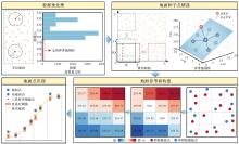
Fig. 1
Flowchart of the algorithm"


Fig. 2
Selection of ground seeds"
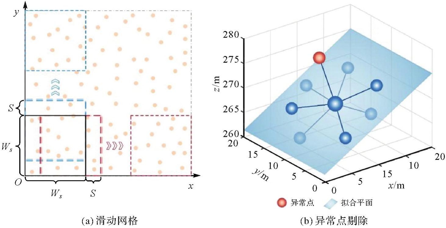
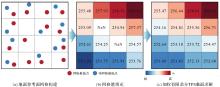
Fig. 3
Flowchart of the ground reference surface"

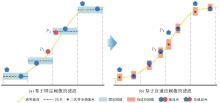
Fig. 4
Adaptive thresholds under the consideration of spatial position error"
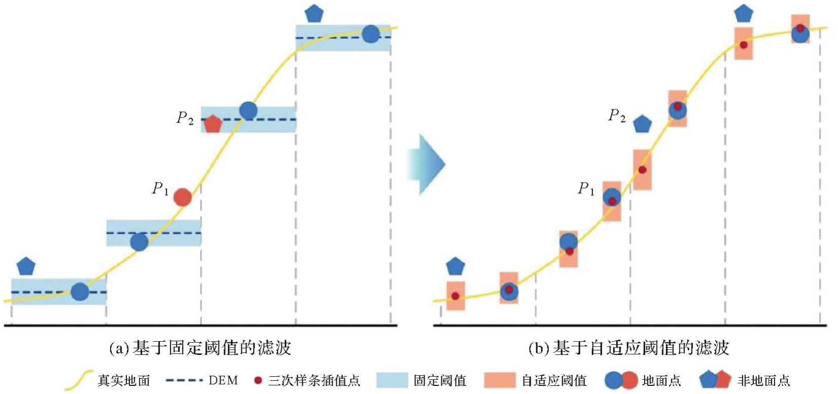
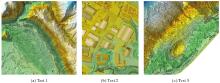
Fig. 5
DSMs of the OpenGF datasets"
Tab. 1
Statistical information of OpenGF datasets"
| 样本区域 | 样本特征 | 地面点数 | 非地面点数 | 点云密度/(pts/m2) | 平均地形坡度/(°) |
|---|---|---|---|---|---|
| Test 1 | 农村、城市、混合地形 | 20 599 329 | 26 233 254 | 7.09 | 19.30 |
| Test 2 | 大型建筑物 | 3 095 510 | 3 135 353 | 5.41 | 3.77 |
| Test 3 | 陡坡上的密集植被、梯田 | 3 602 430 | 16 161 901 | 7.19 | 16.16 |
Tab. 2
Optimized parameters and filtering accuracy of the proposed method on the OpenGF datasets"
| 样本区域 | 参数 | 精度 | ||||||
|---|---|---|---|---|---|---|---|---|
| Ws/m | h/m | k | t0/m | TⅠ/(%) | TⅡ/(%) | TE/(%) | Kappa/(%) | |
| Test 1 | 12 | 1.00 | 0.10 | 0.06 | 1.73 | 1.84 | 1.79 | 96.37 |
| Test 2 | 90 | 1.00 | 0.50 | 0.01 | 1.35 | 6.44 | 3.91 | 92.18 |
| Test 3 | 14 | 1.00 | 0.15 | 0.06 | 2.69 | 1.42 | 1.65 | 94.54 |
| 平均值 | 1.92 | 3.23 | 2.45 | 94.37 | ||||
| 标准差 | 0.56 | 2.28 | 1.03 | 1.72 | ||||
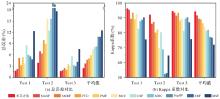
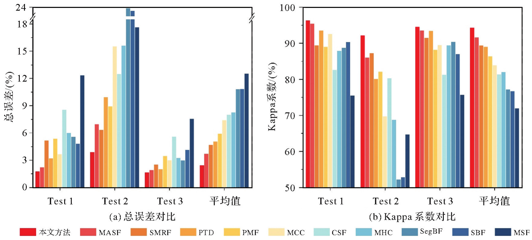
Fig. 6
Comparision of accuracy between the proposed method and others filtering methods"
Tab. 3
Comparision of accuracy between the proposed method and other filtering methods"
| 样本区域 | 指标 | 本文方法 | SMRF | PTD | MASF | PMF | MCC | CSF | MHC | SegBF | SBF | MSF |
|---|---|---|---|---|---|---|---|---|---|---|---|---|
| Test 1 | 总误差 | 1.79 | 2.24 | 5.19 | 3.21 | 5.39 | 3.67 | 8.57 | 5.99 | 5.58 | 4.82 | 12.35 |
| Kappa系数 | 96.37 | 95.45 | 89.49 | 93.52 | 89.00 | 92.55 | 82.61 | 87.91 | 88.78 | 90.32 | 75.56 | |
| Test 2 | 总误差 | 3.91 | 6.98 | 6.35 | 9.94 | 8.94 | 15.53 | 12.48 | 15.64 | 23.90 | 23.61 | 17.64 |
| Kappa系数 | 92.18 | 86.05 | 87.29 | 80.12 | 82.11 | 69.80 | 80.27 | 68.77 | 52.29 | 52.88 | 64.71 | |
| Test 3 | 总误差 | 1.65 | 1.93 | 2.52 | 2.01 | 3.47 | 3.03 | 5.61 | 3.26 | 3.00 | 4.15 | 7.57 |
| Kappa系数 | 94.54 | 93.57 | 91.47 | 93.45 | 88.17 | 89.55 | 81.28 | 89.46 | 90.37 | 86.99 | 75.68 | |
| 平均值 | 总误差 | 2.45 | 3.72 | 4.69 | 5.05 | 5.93 | 7.41 | 8.02 | 8.30 | 10.83 | 10.86 | 12.52 |
| Kappa系数 | 94.37 | 91.69 | 89.42 | 89.03 | 86.43 | 83.97 | 81.39 | 82.05 | 77.15 | 76.73 | 71.98 |
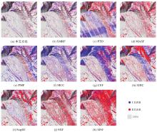
Fig. 7
Error distribution of the proposed method and other filtering methods on Test 1"

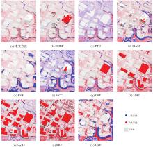
Fig. 8
Error distribution of the proposed method and other filtering methods on Test 2"

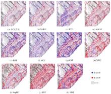
Fig. 9
Error distribution of the proposed method and other filtering methods on Test 3"
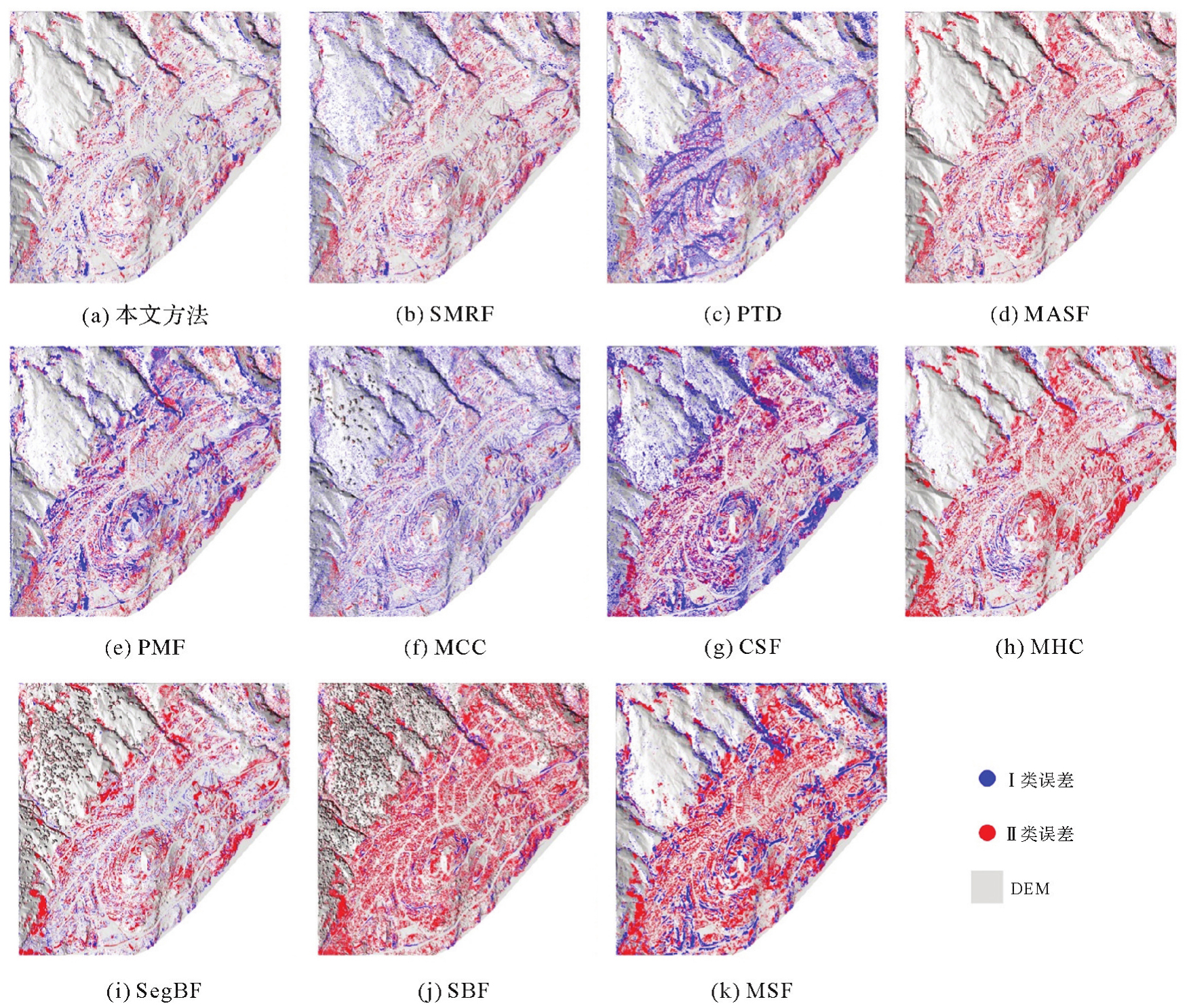
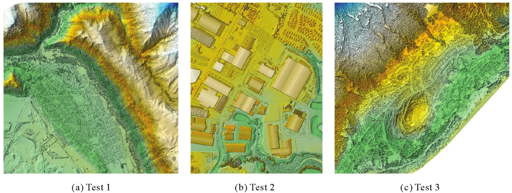
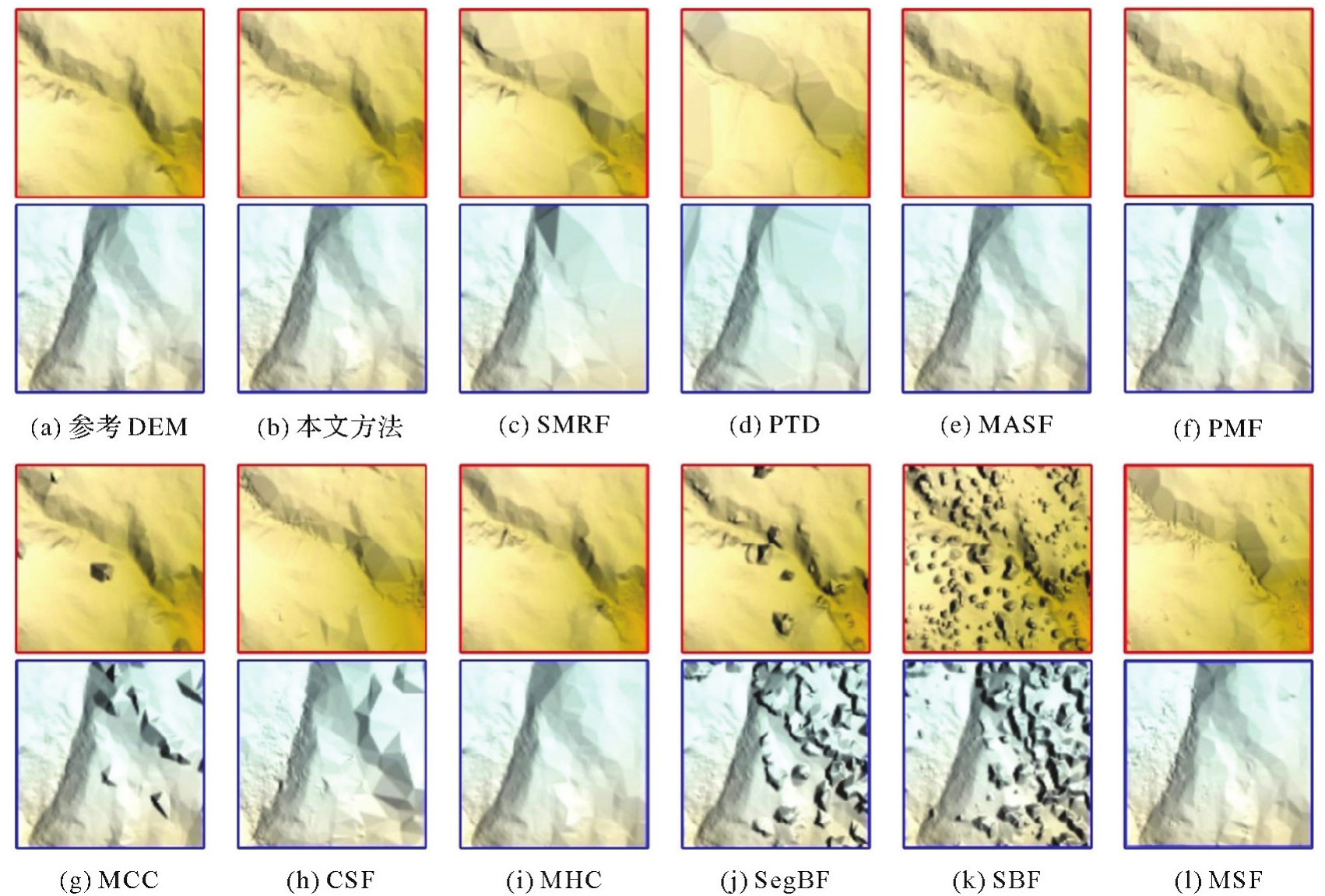
Fig. 10
Local DEMs of the proposed method and other filtering methods on Test 3"
Tab. 4
Computational costs of the proposed method and other filtering methods on the OpenGF datasets"
| 样本区域 | 本文方法 | SMRF | PTD | MASF | PMF | MCC | CSF | MHC | SegBF | SBF | MSF |
|---|---|---|---|---|---|---|---|---|---|---|---|
| Test 1 | 7.62 | 21.60 | 4.53 | 135.63 | 143.50 | 77.00 | 27.65 | 599.36 | 17.24 | 3.82 | 1.18 |
| Test 2 | 1.87 | 3.63 | 0.45 | 16.46 | 40.99 | 1 715.00 | 3.36 | 224.97 | 2.14 | 0.38 | 0.26 |
| Test 3 | 4.25 | 6.32 | 1.28 | 29.83 | 81.80 | 71.12 | 10.90 | 288.46 | 7.20 | 0.78 | 0.39 |
| 平均值 | 4.58 | 10.52 | 2.09 | 60.64 | 88.76 | 621.04 | 13.97 | 370.93 | 8.86 | 1.66 | 0.61 |
Tab. 5
Total error comparison of OpenGF datasets in ablation test"
| 样本区域 | 本文方法 | 无贡献点① | 无贡献点② | 无贡献点③ |
|---|---|---|---|---|
| Test 1 | 1.67 | 2.13 | 1.95 | 1.78 |
| Test 2 | 4.23 | 4.95 | 4.37 | 5.39 |
| Test 3 | 1.80 | 2.31 | 2.31 | 1.98 |
| [1] |
郭娇娇, 陈传法, 姚喜, 等. 基于多特征聚类的复杂环境机载点云层次滤波方法[J]. 测绘学报, 2023, 52(10): 1724-1737. DOI: .
doi: 10.11947/j.AGCS.2023.20220371 |
|
GUO Jiaojiao, CHEN Chuanfa, YAO Xi, et al. A multi-feature clustering-based hierarchical filtering method for airborne LiDAR point clouds in complex landscapes[J]. Acta Geodaetica et Cartographica Sinica, 2023, 52(10): 1724-1737. DOI: .
doi: 10.11947/j.AGCS.2023.20220371 |
|
| [2] |
杨宇妍, 臧玉府, 肖雄武, 等. 基于地形断裂线约束的机载激光点云高精度滤波方法[J]. 测绘学报, 2023, 52(12): 2164-2177. DOI: .
doi: 10.11947/j.AGCS.2023.20220616 |
|
YANG Yuyan, ZANG Yufu, XIAO Xiongwu, et al. An accurate breakline-aware filtering method for airborne laser scanning point clouds[J]. Acta Geodaetica et Cartographica Sinica, 2023, 52(12): 2164-2177. DOI: .
doi: 10.11947/j.AGCS.2023.20220616 |
|
| [3] | HUI Zhenyang, HU Youjian, YEVENYO Y, et al. An improved morphological algorithm for filtering airborne LiDAR point cloud based on multi-level Kriging interpolation[J]. Remote Sensing, 2016, 8(1): 35. |
| [4] | HU Han, DING Yulin, ZHU Qing, et al. An adaptive surface filter for airborne laser scanning point clouds by means of regularization and bending energy[J]. ISPRS Journal of Photogrammetry and Remote Sensing, 2014, 92: 98-111. |
| [5] | 汪文琪, 李宗春, 付永健, 等. 一种多尺度自适应点云坡度滤波算法[J]. 武汉大学学报(信息科学版), 2022, 47(3): 438-446. |
| WANG Wenqi, LI Zongchun, FU Yongjian, et al. A multi-scale adaptive slope filtering algorithm for point cloud[J]. Geomatics and Information Science of Wuhan University, 2022, 47(3): 438-446. | |
| [6] | ZHANG Jixian, LIN Xiangguo. Filtering airborne LiDAR data by embedding smoothness-constrained segmentation in progressive TIN densification[J]. ISPRS Journal of Photogrammetry and Remote Sensing, 2013, 81: 44-59. |
| [7] | DAI Hengming, HU Xiangyun, SHU Zhen, et al. Deep ground filtering of large-scale ALS point clouds via iterative sequential ground prediction[J]. Remote Sensing, 2023, 15(4): 961. |
| [8] | HUI Zhenyang, WU Beiping, HU Youjian, et al. Improved progressive morphological filter for digital terrain model generation from airborne LiDAR data[J]. Applied Optics, 2017, 56(34): 9359-9367. |
| [9] | NIE Sheng, WANG Cheng, DONG Pinliang, et al. A revised progressive TIN densification for filtering airborne LiDAR data[J]. Measurement, 2017, 104: 70-77. |
| [10] | VOSSELMAN G. Slope based filtering of laser altimetry data[J]. International Archives of Photogrammetry and Remote Sensing, 2000, 33: 935-942. |
| [11] | CHEN Chuanfa, GUO Jiaojiao, LI Yanyan, et al. Segmentation-based hierarchical interpolation filter using both geometric and radiometric features for LiDAR point clouds over complex scenarios[J]. Measurement, 2023, 211: 112668. |
| [12] | QIN Nannan, TAN Weikai, GUAN Haiyan, et al. Towards intelligent ground filtering of large-scale topographic point clouds: a comprehensive survey[J]. International Journal of Applied Earth Observation and Geoinformation, 2023, 125: 103566. |
| [13] | CHEN Chuanfa, LI Yanyan, LI Wei, et al. A multiresolution hierarchical classification algorithm for filtering airborne LiDAR data[J]. ISPRS Journal of Photogrammetry and Remote Sensing, 2013, 82: 1-9. |
| [14] | PLEANSAMAI K. M-estimator sample consensus planar extraction from image-based 3D point cloud for building information modelling[J]. International Journal of GEOMATE, 2019, 17(63): 69-76. |
| [15] | CHEN Chuanfa, CHANG Bingtao, LI Yanyan, et al. Filtering airborne LiDAR point clouds based on a scale-irrelevant and terrain-adaptive approach[J]. Measurement, 2021, 171: 108756. |
| [16] | GARCIA D. Robust smoothing of gridded data in one and higher dimensions with missing values[J]. Computational Statistics & Data Analysis, 2010, 54(4): 1167-1178. |
| [17] | CHEN Chuanfa, LI Yanyan, ZHAO Na, et al. A fast and robust interpolation filter for airborne lidar point clouds[J]. PLoS One, 2017, 12(5): e0176954. |
| [18] | PINGEL T J, CLARKE K C, MCBRIDE W A. An improved simple morphological filter for the terrain classification of airborne LiDAR data[J]. ISPRS Journal of Photogrammetry and Remote Sensing, 2013, 77: 21-30. |
| [19] | QIN Nannan, TAN Weikai, MA Lingfei, et al. Deep learning for filtering the ground from ALS point clouds: a dataset, evaluations and issues[J]. ISPRS Journal of Photogrammetry and Remote Sensing, 2023, 202: 246-261. |
| [20] | ZHANG Keqi, CHEN S C, WHITMAN D, et al. A progressive morphological filter for removing nonground measurements from airborne LIDAR data[J]. IEEE Transactions on Geoscience and Remote Sensing, 2003, 41(4): 872-882. |
| [21] | AXELSSON P. DEM generation from laser scanner data using adaptive TIN models[J]. International Archives of Photogrammetry and Remote Sensing, 2000, 33(4): 110-117. |
| [22] | EVANS J S, HUDAK A T. A multiscale curvature algorithm for classifying discrete return LiDAR in forested environments[J]. IEEE Transactions on Geoscience and Remote Sensing, 2007, 45(4): 1029-1038. |
| [23] |
朱笑笑, 王成, 习晓环, 等. 多级移动曲面拟合的自适应阈值点云滤波方法[J]. 测绘学报, 2018, 47(2): 153-160. DOI: .
doi: 10.11947/j.AGCS.2018.20170491 |
|
ZHU Xiaoxiao, WANG Cheng, XI Xiaohuan, et al. Hierarchical threshold adaptive for point cloud filter algorithm of moving surface fitting[J]. Acta Geodaetica et Cartographica Sinica, 2018, 47(2): 153-160. DOI: .
doi: 10.11947/j.AGCS.2018.20170491 |
|
| [24] | ZHANG Wuming, QI Jianbo, WAN Peng, et al. An easy-to-use airborne LiDAR data filtering method based on cloth simulation[J]. Remote Sensing, 2016, 8(6): 501. |
| [25] | CAO Di, WANG Cheng, DU Meng, et al. A multiscale filtering method for airborne LiDAR data using modified 3D alpha shape[J]. Remote Sensing, 2024, 16(8): 1443. |
| [26] |
詹总谦, 胡孟琦, 满益云. 多尺度区域生长点云滤波地表拟合法[J]. 测绘学报, 2020, 49(6): 757-766. DOI: .
doi: 10.11947/j.AGCS.2020.20190142 |
|
ZHAN Zongqian, HU Mengqi, MAN Yiyun. Multi-scale region growing point cloud filtering method based on surface fitting[J]. Acta Geodaetica et Cartographica Sinica, 2020, 49(6): 757-766. DOI: .
doi: 10.11947/j.AGCS.2020.20190142 |
| [1] | Dongdong PU, Hongzhou CHAI, Yongzhong OUYANG, Chao DONG. Hierarchical encryption matching algorithm for adjacent strip splicing in airborne LiDAR bathymetry [J]. Acta Geodaetica et Cartographica Sinica, 2025, 54(8): 1439-1451. |
| [2] | Dianpeng SU, Bin WANG, Xiaozheng MAI, Huang MENG, Chao QI, Fanlin YANG. Calibration of placement angle errors of airborne bathymetric LiDAR without field control [J]. Acta Geodaetica et Cartographica Sinica, 2025, 54(6): 1042-1053. |
| [3] | Liying WANG, Kangli ZHANG, Xinao LI, Ze YOU, Yong FENG. An algorithm for building extraction from airborne LiDAR data under adaptive local spatial-spectral consistency [J]. Acta Geodaetica et Cartographica Sinica, 2024, 53(12): 2349-2360. |
| [4] | LI Pengfei, LI Dou, HU Jinfei, YAO Wanqiang, ZANG Yuzhe. Assessing the ability of airborne LiDAR to monitor soil erosion on the Chinese Loess Plateau [J]. Acta Geodaetica et Cartographica Sinica, 2023, 52(8): 1342-1354. |
| [5] | WANG Dandi, XU Qing, XING Shuai, LIN Yuzhun, ZHANG Guoping. Semi-empirical waveform decomposition method for correction of near water surface penetration error in airborne LiDAR bathymetry [J]. Acta Geodaetica et Cartographica Sinica, 2023, 52(6): 944-955. |
| [6] | SU Dianpeng, YAN Doudou, CHEN Liang, CHEN Yu, DONG Jian, WU Di, YU Xiaolin. Surface-volume-bottom joint-filtering algorithm for Airborne LiDAR bathymetric point cloud [J]. Acta Geodaetica et Cartographica Sinica, 2023, 52(4): 614-623. |
| [7] | WANG Liying, WU Ji, YOU Ze, LI Yu, CAMARA Mahamadou. Urban object classification of multispectral airborne LiDAR data with multidimensional Gauss mixture model and neighborhood constraints [J]. Acta Geodaetica et Cartographica Sinica, 2023, 52(3): 419-431. |
| [8] | GUO Jiaojiao, CHEN Chuanfa, YAO Xi, LIU Yan, LIU Yating, LIU Panpan. A multi-feature clustering-based hierarchical filtering method for airborne LiDAR point clouds in complex landscapes [J]. Acta Geodaetica et Cartographica Sinica, 2023, 52(10): 1724-1737. |
| [9] | WANG Dandi, XING Shuai, XU Qing, LIN Yuzhun, LI Pengcheng. Automatic sea-land waveform classification method for single-wavelength airborne LiDAR bathymetry [J]. Acta Geodaetica et Cartographica Sinica, 2022, 51(5): 750-761. |
| [10] | HUANG Mingyi, WU Jun, GAO Jiongli. Seamless spherical video generation for multi-head panoramic camera(MPC) [J]. Acta Geodaetica et Cartographica Sinica, 2022, 51(5): 703-717. |
| [11] | XU Qiang, GUO Chen, DONG Xiujun. Application status and prospect of aerial remote sensing technology for geohazards [J]. Acta Geodaetica et Cartographica Sinica, 2022, 51(10): 2020-2033. |
| [12] | ZHAO Chuan, GUO Haitao, LU Jun, YU Donghang, LIN Yuzhun, JIANG Huaigang. Roof segmentation from airborne LiDAR by combining region growing with random sample consensus [J]. Acta Geodaetica et Cartographica Sinica, 2021, 50(5): 621-633. |
| [13] | SHEN Dingtao, QIAN Tianlu, XIA Yu, CHEN Beiqing, ZHANG Yu, WANG Jiechen. A ring detection method for levee features extraction based on airborne LiDAR data [J]. Acta Geodaetica et Cartographica Sinica, 2021, 50(2): 203-214. |
| [14] | ZHAN Zongqian, HU Mengqi, MAN Yiyun. Multi-scale region growing point cloud filtering method based on surface fitting [J]. Acta Geodaetica et Cartographica Sinica, 2020, 49(6): 757-766. |
| [15] | ZHAO Chuan, GUO Haitao, LU Jun, YU Donghang, ZHANG Baoming. Airborne LiDAR point cloud classification based on deep residual network [J]. Acta Geodaetica et Cartographica Sinica, 2020, 49(2): 202-213. |
| Viewed | ||||||
|
Full text |
|
|||||
|
Abstract |
|
|||||