


测绘学报 ›› 2026, Vol. 55 ›› Issue (4): 604-617.doi: 10.11947/j.AGCS.2026.20250393
付波霖1( ), 黄柯越1, 杨艳丽2, 孙伟伟3,4,5(), 王朝茵1
收稿日期:2025-09-19
修回日期:2026-03-13
出版日期:2026-05-11
发布日期:2026-05-11
通讯作者:
孙伟伟
E-mail:fubolin@glut.edu.cn;sunweiwei@nbu.edu.cn
作者简介:付波霖(1988—),男,教授,研究方向为湿地精细遥感。 E-mail:fubolin@glut.edu.cn
基金资助:
bolin FU1(), Keyue HUANG1, Yanli YANG2, Weiwei SUN3,4,5(), Zhaoyin WANG1
Received:2025-09-19
Revised:2026-03-13
Online:2026-05-11
Published:2026-05-11
Contact:
Weiwei SUN
E-mail:fubolin@glut.edu.cn;sunweiwei@nbu.edu.cn
About author:FU Bolin (1988—), male, professor, majors in fine wetland remote sensing. E-mail: fubolin@glut.edu.cn
Supported by:摘要:
红树林作为海岸带生态系统的重要组成部分,探明其中的土壤有机碳(SOC)含量对评估海岸带生态系统的储碳能力具有重大意义。目前国内外对于红树林土壤的研究比较匮乏,为解决红树林土壤光谱特征不明晰,SOC敏感光谱子域难探索的问题,本文提出连续小波光谱相似角解析方法(CSS),用于系统解析红树林土壤光谱响应机制;同时构建土壤敏感光谱子域捕捉方法,实现多场景下SOC敏感光谱子域的精准挖掘。以地面原位全谱段高光谱数据(350~2500 nm)为数据源,联合上述方法探究不同深度、树种及生境3类场景下红树林土壤的光谱反射机理,并进一步构建自适应集成模型(AEL),完成3类场景下SOC含量的高精度反演。在此基础上,通过因子分析量化3类场景对SOC含量的影响程度,结合显著性检验,揭示红树林SOC含量与深度、树种、生境的内在关联。研究结果表明:①400~800 nm波段区间的土壤光谱与红树林SOC含量存在显著相关性,其中600 nm附近光谱与SOC含量的线性关联更为突出;②不同深度土壤的敏感光谱子域主要集中于350~800 nm波段,不同树种土壤的敏感光谱子域以600~900 nm波段为主,而不同生境土壤的敏感光谱子域则分布于350~900 nm与1500~2200 nm两个波段区间;③AEL模型可有效实现SOC含量高精度反演,在42个反演方案中,决定系数R2介于0.46~0.98之间,即0~60 cm土壤深度范围内,0~10 cm土层的SOC反演效果最优(R2=0.96),且该土层SOC含量最高,占比达25.05%;5个红树林树种中,海莲林下土壤的SOC反演效果最佳(R2=0.97),其SOC含量亦最高,占比为27.16%;3种生境中,近自然恢复区的SOC反演精度最高,且SOC含量占比达45.24%。本文系统阐明了不同场景下红树林土壤的光谱响应机制,精准捕获其SOC诊断性光谱波段,实现了SOC含量的高精度反演,其中红树林土壤诊断性谱段的挖掘能够精准匹配卫星影像的波段,为大范围、多场景下海岸带蓝碳的高光谱遥感估算提供了科学支撑。
中图分类号:
付波霖, 黄柯越, 杨艳丽, 孙伟伟, 王朝茵. 基于实测全谱段高光谱数据的多场景红树林土壤光谱响应特性解析及土壤有机碳含量反演[J]. 测绘学报, 2026, 55(4): 604-617.
bolin FU, Keyue HUANG, Yanli YANG, Weiwei SUN, Zhaoyin WANG. Multi-scene analysis of mangrove soil spectral response characteristics and inversion of soil organic carbon content based on measured full-spectrum hyperspectral data[J]. Acta Geodaetica et Cartographica Sinica, 2026, 55(4): 604-617.
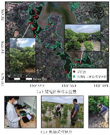
图1
研究区采样点位置及现场数据采集"
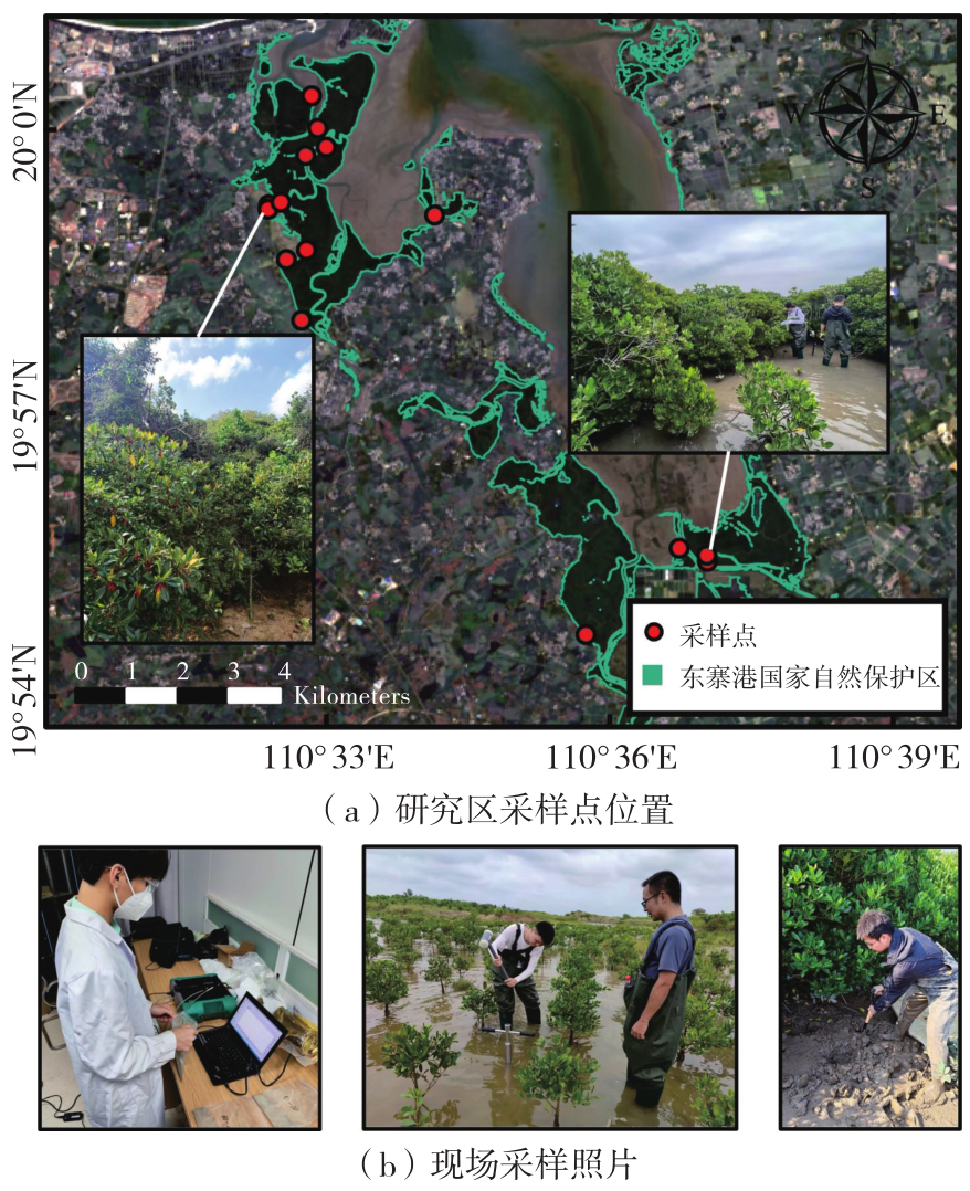
图2
技术路线"
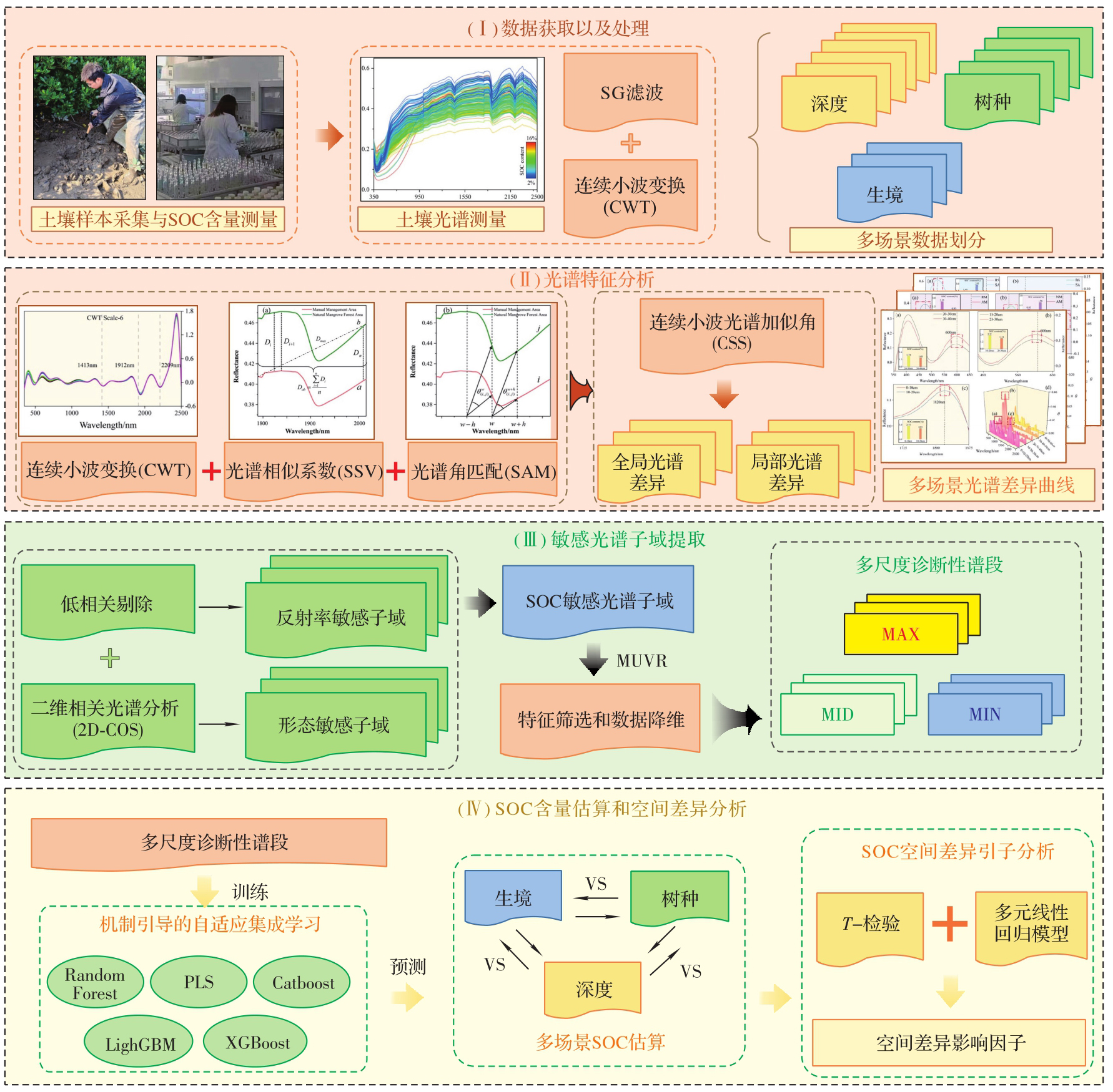
图3
不同土壤深度之间的SAM曲线"
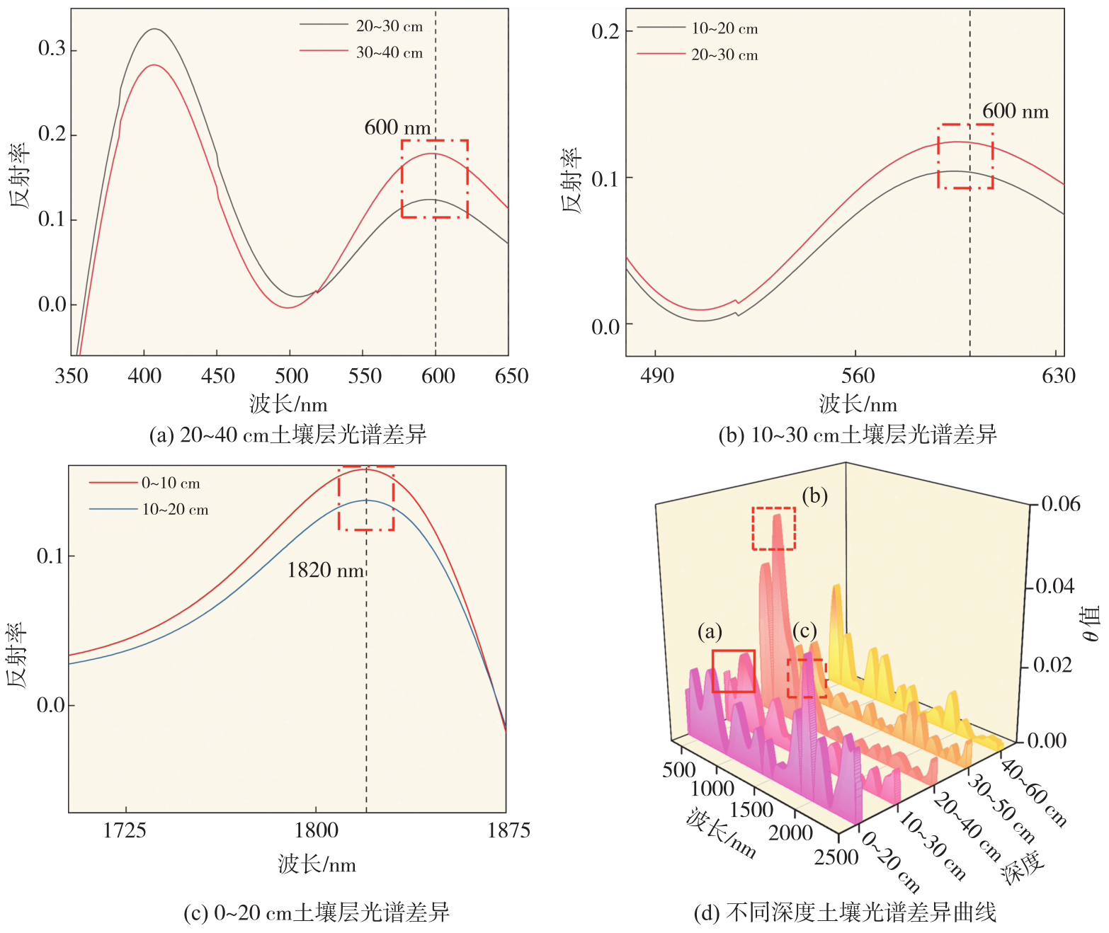
图4
不同树种土壤之间的SAM曲线"
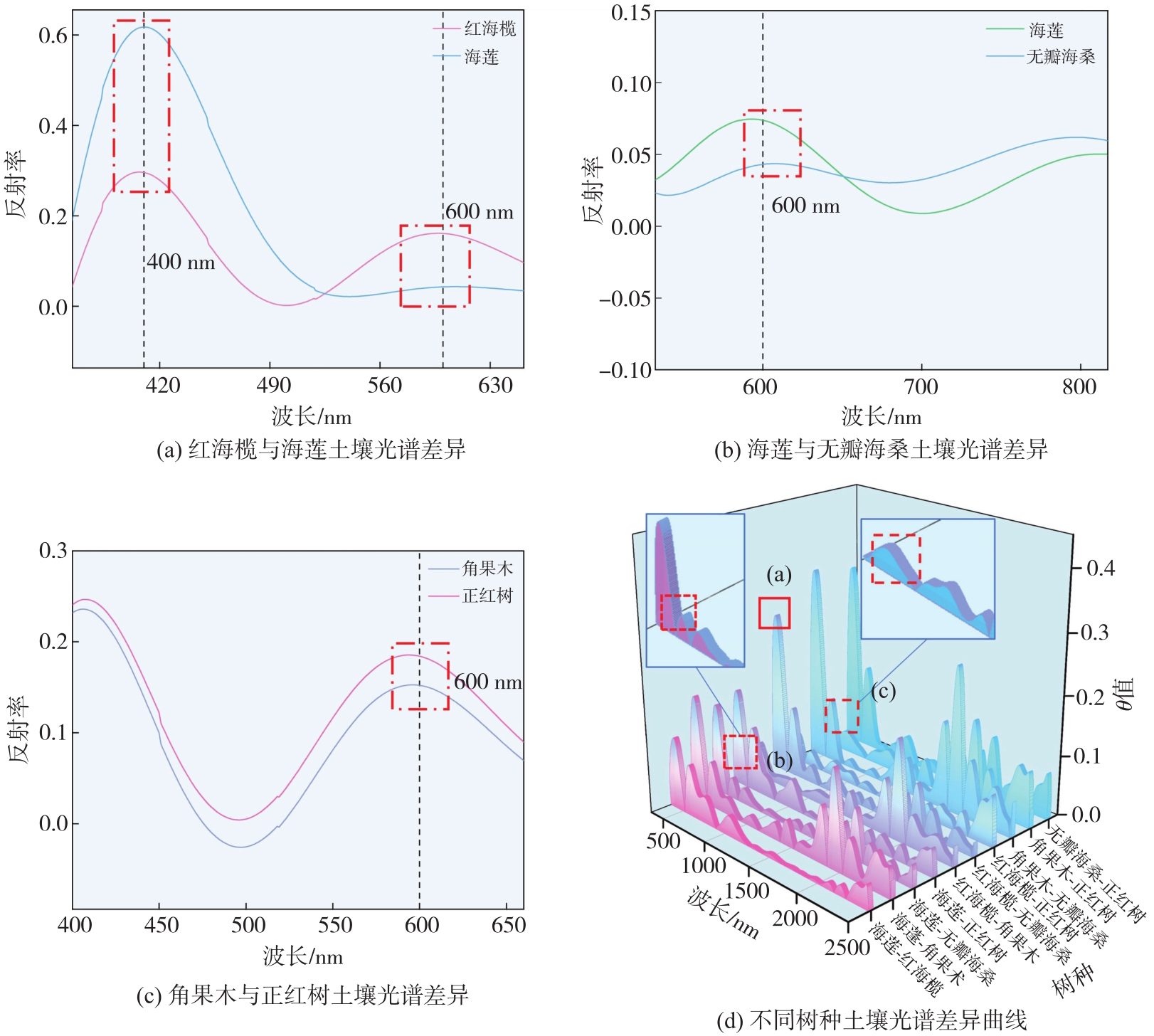
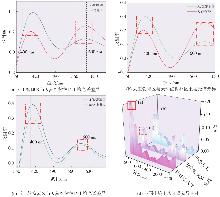
图5
不同生境土壤之间的SAM曲线"
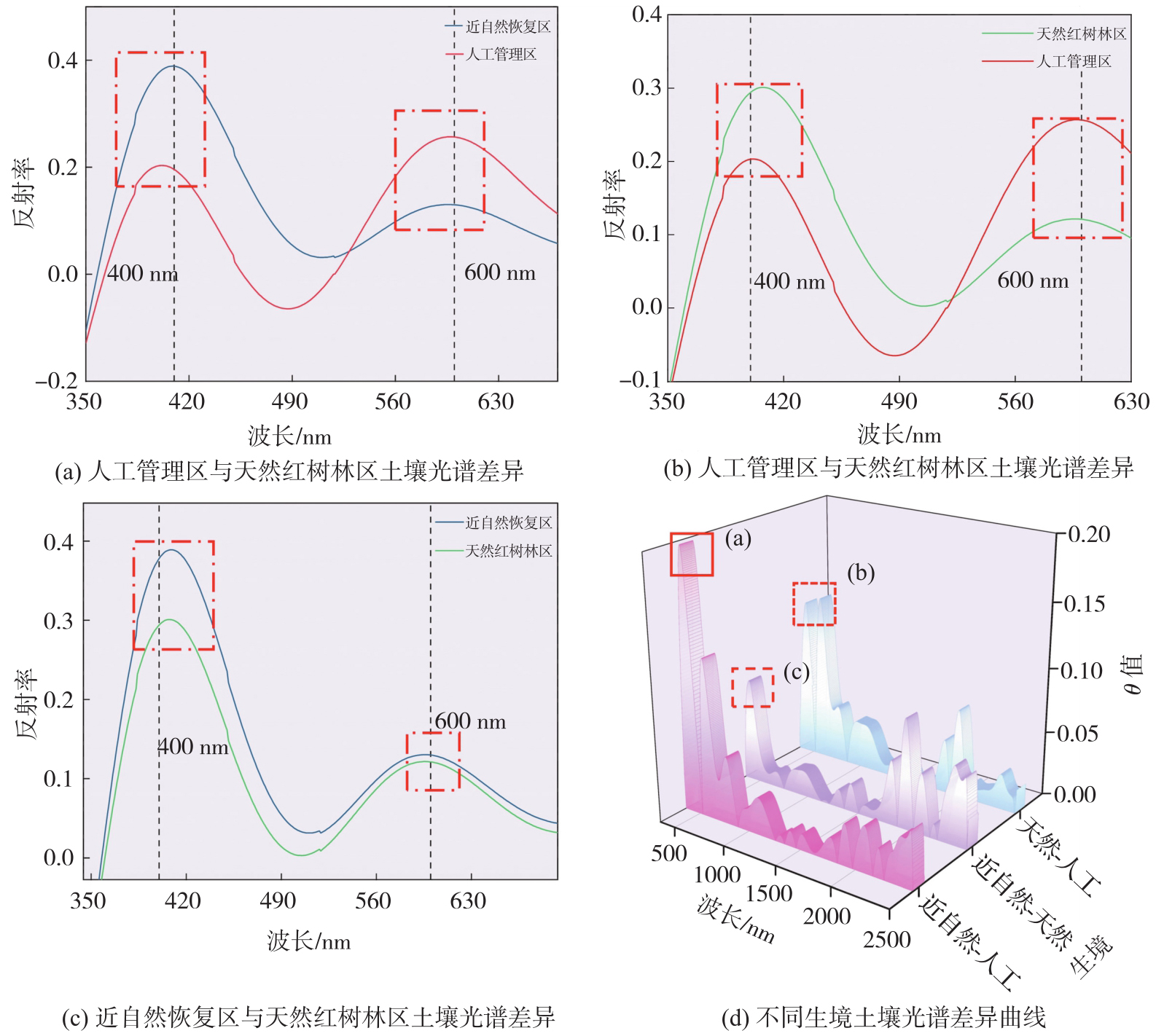
图6
不同深度的SOC敏感光谱子域和诊断性谱段"
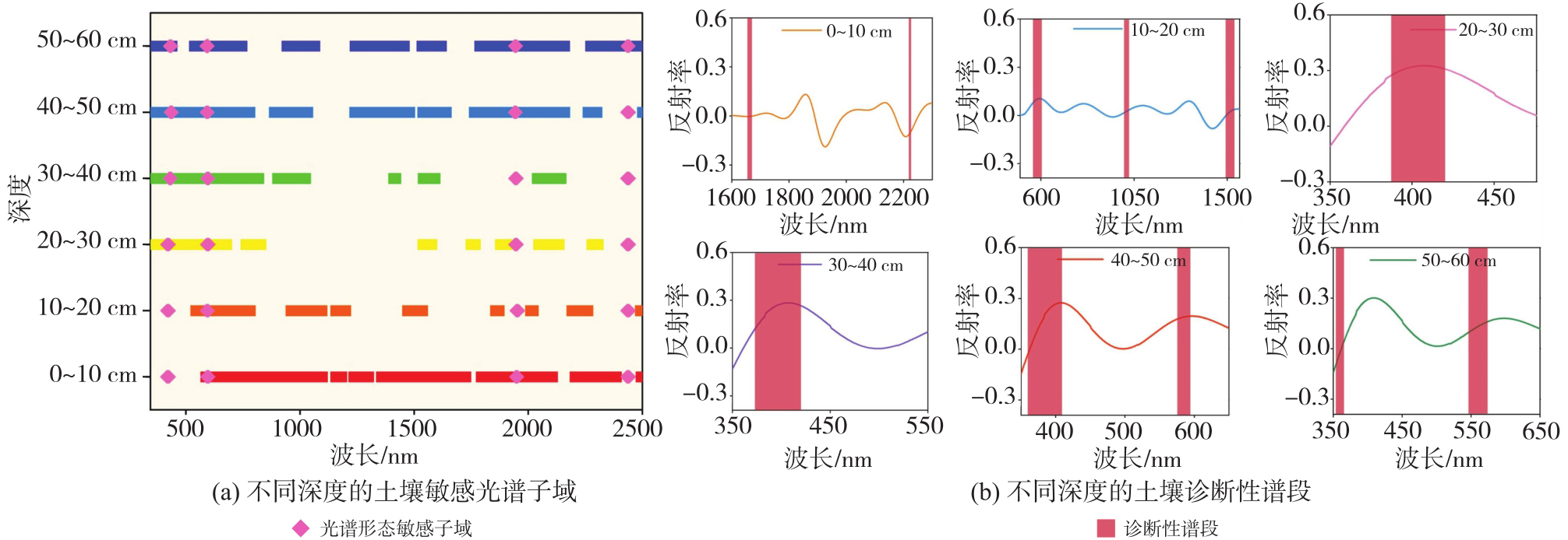
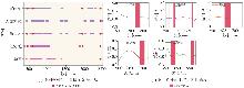
图7
不同树种的SOC敏感光谱子域和诊断性谱段"
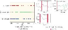
图8
不同生境的SOC敏感光谱子域和诊断性谱段"
表1
不同土壤深度下红树林SOC反演结果"
| 深度/cm | 反演精度(R2) | 最优反演基模型 | ||||
|---|---|---|---|---|---|---|
| Max | Mid | Min | Max | Mid | Min | |
| 0~10 | 0.65 | 0.95 | 0.96 | AEL-PLS | AEL-XGBoost | AEL-RF |
| 10~20 | 0.60 | 0.55 | 0.46 | AEL-RF | AEL-PLS | AEL-PLS |
| 20~30 | 0.75 | 0.77 | 0.76 | AEL-PLS | AEL-PLS | AEL-PLS |
| 30~40 | 0.88 | 0.82 | 0.50 | AEL-RF | AEL-PLS | AEL-PLS |
| 40~50 | 0.82 | 0.63 | 0.57 | AEL-XGBoost | AEL-PLS | AEL-PLS |
| 50~60 | 0.90 | 0.79 | 0.71 | AEL-XGBoost | AEL-RF | AEL-XGBoost |
表2
不同树种土壤的红树林SOC反演结果"
| 树种 | 反演精度(R2) | 最优反演基模型 | ||||
|---|---|---|---|---|---|---|
| Max | Mid | Min | Max | Mid | Min | |
| 海莲 | 0.95 | 0.97 | 0.97 | PLS | PLS | PLS |
| 角果木 | 0.80 | 0.92 | 0.66 | AEL-PLS | AEL-XGBoost | AEL-RF |
| 红海榄 | 0.78 | 0.85 | 0.86 | AEL-RF | AEL-PLS | AEL-PLS |
| 正红树 | 0.98 | 0.96 | 0.99 | PLS | PLS | PLS |
| 无瓣海桑 | 0.96 | 0.95 | 0.94 | PLS | PLS | PLS |
表3
不同生境土壤的红树林SOC反演结果"
| 生境 | 反演精度(R2) | 最优反演基模型 | ||||
|---|---|---|---|---|---|---|
| Max | Mid | Min | Max | Mid | Min | |
| 天然红树林区 | 0.70 | 0.61 | 0.62 | AEL-LightGBM | AEL-PLS | AEL-RF |
| 近自然恢复区 | 0.85 | 0.62 | 0.76 | AEL-PLS | AEL-PLS | AEL-PLS |
| 人工管理区 | 0.71 | 0.73 | 0.78 | AEL-PLS | AEL-PLS | AEL-Catboost |
图9
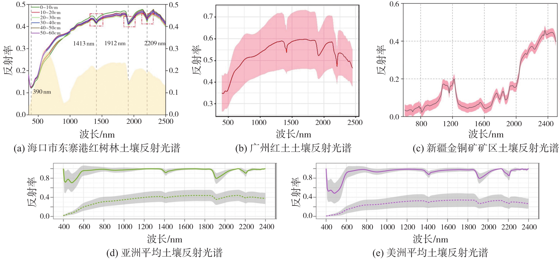
不同类型土壤的光谱曲线"
| [1] | LOVELOCK C E, REEF R Variable impacts of climate change on blue carbon[J]. One Earth, 2020, 3(2): 195-211. |
| [2] | CEANTURI A, TUAHATU J W, LOKOLLO F F, et al. Mangrove ecosystems in southeast Asia region: mangrove extent, blue carbon potential and CO2 emissions in 1996—2020[J]. Science of the Total Environment, 2024(915): 170052. |
| [3] | SHARMA S, SUWA R, RAY R, et al. Preface: blue carbon studies in Asia-Pacific regions: current status, gaps, and future perspectives[J]. Ecological Research, 2022, 37(1): 5-8. |
| [4] | HUANG X, WANG X, LI X, et al. Distribution pattern and influencing factors for soil organic carbon (SOC) in mangrove communities at Dongzhaigang, China[J]. Journal of Coastal Research, 2018, 34(2): 434-442. |
| [5] | BARRETO M B, LO MÓNACO S, DÍAZ R, et al. Soil organic carbon of mangrove forests (Rhizophora and Avicennia) of the Venezuelan Caribbean coast[J]. Organic Geochemistry, 2016, 100: 51-61. |
| [6] | 马文婷, 高若. 蓝碳经济与海洋生态文明协同发展研究[J]. 江苏海洋大学学报(人文社会科学版), 2025, 23(3): 1-10. |
| MA Wenting, GAO Ruo. Research on the coordinated development of blue carbon economy and marine ecological civilization[J]. Journal of Jiangsu Ocean University (Humanities and Social Sciences Edition), 2025, 23(3): 1-10. | |
| [7] | 尹成卓, 高小红, 宋奇, 等. 基于Sentinel-2影像的农田土壤有机碳含量估算——以湟水流域典型区域为例[J]. 激光与光电子学进展, 2025, 62(12): 294-305. |
| YIN Chengzhuo, GAO Xiaohong, SONG, Qi, et al. Estimation of soil organic carbon content in farmland based on Sentinel-2 imagery: case study of a typical area in the Huangshui river basin[J]. Laser & Optoelectronics Progress, 2025, 62(12): 294-305. | |
| [8] | 曹霸, 凌成星. 基于GF-1遥感数据的若尔盖高寒沼泽湿地地上生物量与土壤有机碳密度估算[J]. 遥感技术与应用, 2021, 36(1): 229-236. |
| CAO Ba, LING Chengxing, Estimation of aboveground biomass and soil organic carbon density of Zoige Alpine wetland based on GF-1 remote sensing data[J]. Remote Sensing Technology and Application, 2021, 36(1): 229-236. | |
| [9] | HUANG C, GONG W, PANG Y. Remote sensing and forest carbon monitoring—a review of recent progress, challenges and opportunities[J]. Journal of Geodesy and Geoinformation Science, 2022, 5(2): 124. |
| [10] | 周涛, 史培军, 罗巾英, 等. 基于遥感与碳循环过程模型估算土壤有机碳储量[J]. 遥感学报, 2007(1): 127-136. |
| ZHOU Tao, SHI Peijun, LUO Jinying, et al. Estimation of soil organic carbon based on remote sensing and process model[J]. National Remote Sensing Bulletin, 2007(1): 127-136. | |
| [11] | CASTALDI F, HALIL K M, WETTERLIND J, et al. Assessing the capability of Sentinel-2 time-series to estimate soil organic carbon and clay content at local scale in croplands[J]. ISPRS Journal of Photogrammetry and Remote Sensing, 2023, 199: 40-60. |
| [12] | ŽÍŽALA D, MINAŘÍK R, ZÁDOŘOVÁ T. Soil organic carbon mapping using multispectral remote sensing data: prediction ability of data with different spatial and spectral resolutions[J]. Remote Sensing, 2019, 11(24): 2947. |
| [13] | 杨珺婷, 李晓松. 应用哨兵2号卫星遥感影像数据和机器学习算法对锡林郭勒草原土壤表层有机碳及全氮的估算[J]. 东北林业大学学报, 2022, 50(1): 64-71. |
| YANG Junting, LI Xiaosong. Estimation of topsoil organic carbon and total nitrogen in Xilin Gol grassland using Sentinel-2 and machine learning[J]. Journal of Northeast Forestry University, 2022, 50(1): 64-71. | |
| [14] | XU X, CHEN S, XU Z, et al. Exploring appropriate preprocessing techniques for hyperspectral soil organic matter content estimation in black soil area[J]. Remote Sensing, 2020, 12(22): 3765. |
| [15] | MENG X, BAO Y, LIU J, et al. Regional soil organic carbon prediction model based on a discrete wavelet analysis of hyperspectral satellite data[J]. International Journal of Applied Earth Observation and Geoinformation, 2020, 89: 102111. |
| [16] | XIAO B, LI S, DOU S, et al. Comparison of leaf Chlorophyll content retrieval performance of citrus using FOD and CWT methods with field-based full-spectrum hyperspectral reflectance data[J]. Computers and Electronics in Agriculture, 2024, 217: 108559. |
| [17] | HUANG X, WANG X, BAISHAN K, et al. Hyperspectral estimation of soil organic carbon content based on continuous wavelet transform and successive projection algorithm in arid area of Xinjiang, China[J]. Sustainability, 2023, 15(3): 2587. |
| [18] | XIA K, WU T, ZHANG S, et al. A new method for high-precision estimation of soil organic matter using two-dimensional correlation spectroscopy—to support collaborative use of global open soil spectral libraries[J]. Geoderma, 2024, 445: 116877. |
| [19] | LAUNER H F, TOMIMATSU Y. Rapid accurate determination of carbohydrates and other substances with dichromate heat-of-dilution method[J]. Analytical Chemistry, 1953, 25(11): 1767-1769. |
| [20] | SAVITZKY A, GOLAY M J E. Smoothing and differentiation of data by simplified least squares procedures[J]. Analytical Chemistry, 1964, 36(8): 1627-1639. |
| [21] | RIOUL O, DUHAMEL P. Fast algorithms for discrete and continuous wavelet transforms[J]. IEEE Transactions on Information Theory, 1992, 38(2): 569-586. |
| [22] | FU B, LIANG Y, LAO Z, et al. Quantifying scattering characteristics of mangrove species from Optuna-based optimal machine learning classification using multi-scale feature selection and SAR image time series[J]. International Journal of Applied Earth Observation and Geoinformation, 2023, 122: 103446. |
| [23] | SHEPHERD K D, FERGUSON R, HOOVER D, et al. A global soil spectral calibration library and estimation service[J]. Soil Security, 2022, 7: 100061. |
| [24] | WANG Z, CHEN S, LU R, et al. Non-linear memory-based learning for predicting soil properties using a regional vis-NIR spectral library[J]. Geoderma, 2024, 441: 116752. |
| [25] | ROWLEY M C, NICO P S, BONE S E, et al. Association between soil organic carbon and calcium in acidic grassland soils from Point Reyes National Seashore, CA[J]. Biogeochemistry, 2023, 165(1): 91-111. |
| [26] | WEI D L, BARET F, XING F G, et al. Relating soil surface moisture to reflectance[J]. Remote Sensing of Environment, 2002, 81(2): 238-246. |
| [27] | DING J, YANG A, WANG J, et al. Machine-learning-based quantitative estimation of soil organic carbon content by VIS/NIR spectroscopy[J]. PeerJ, 2018, 6: e5714. |
| [28] | DEMATTÊJ A M, TERRA F D S, QUARTAROLI C F. Spectral behavior of some modal soil profiles from S ã o Paulo State, Brazil[J]. Bragantia, 2012, 71(3): 413-423. |
| [1] | 李鹏, 张家涵, 汪志翰, 王厚杰, 李振洪. 潮间带地形重建方法综述:现状、挑战与趋势[J]. 测绘学报, 2026, 55(4): 571-587. |
| [2] | 吴岚昕, 彭江涛, 孙伟伟, 杨冰. 面向海岸带湿地高光谱遥感的欧拉映射与互补特征建模变化检测方法[J]. 测绘学报, 2026, 55(4): 618-631. |
| [3] | 高二涛, 刘静, 李淑瑾, 周国清, 付波霖, 李淑娴. 光学遥感与SAR协同的茅尾海潮滩多维时空演变监测与分析[J]. 测绘学报, 2026, 55(4): 632-646. |
| [4] | 徐豪, 徐南, 辛会超, 马跃, 涂伟, 李清泉. 基于ICESat-2卫星高度计数据的潮间带地形光子提取方法[J]. 测绘学报, 2026, 55(4): 658-672. |
| [5] | 布金伟, 刘淑慧, 徐顺双, 向彤粟, 汪秋兰, 籍超颖, 左小清. 星载GNSS-R全球海浪波周期估计的经验模型构建[J]. 测绘学报, 2026, 55(4): 684-697. |
| [6] | 杨泽鑫. 基于点云数据的建筑物多细节层次模型重建关键技术研究[J]. 测绘学报, 2026, 55(4): 755-755. |
| [7] | 姚永祥. 基于广义相似性特征的多模态遥感影像稳健匹配[J]. 测绘学报, 2026, 55(4): 757-757. |
| [8] | 续东. 基于多源三维底座数据的全局定位关键技术研究[J]. 测绘学报, 2026, 55(4): 760-760. |
| [9] | 叶晨鸣, 康志忠, 才谨豪, 左秉正, 邵帅, 李彦. 形态特征引导的月表地理实体实景三维建模方法[J]. 测绘学报, 2026, 55(3): 525-535. |
| [10] | 王美莲. 基于手持激光雷达点云的树种分类及枝叶分离研究[J]. 测绘学报, 2026, 55(3): 569-569. |
| [11] | 彭代锋, 刘雪莲, 鲁梦飞, 管海燕. 基于多尺度跨模态特征融合的异源遥感影像洪水变化检测[J]. 测绘学报, 2026, 55(2): 328-343. |
| [12] | 胡浩鹏, 吴杭彬, 战仕浩, 温在豪, 刘春. 视觉点云质量优化支持的道路杆状物变化检测[J]. 测绘学报, 2026, 55(2): 344-358. |
| [13] | 余东行. 高分辨率遥感影像场景与目标识别技术研究[J]. 测绘学报, 2026, 55(2): 377-377. |
| [14] | 韩斌, 黄欣, 李丰毅, 卢晓珍. 一种双编码器自适应特征融合的SAR图像水体分割网络[J]. 测绘学报, 2026, 55(1): 101-113. |
| [15] | 党宇, 朱建军, 付海强, 赵海涛, 陈海鹏. 扩散特征约束的小样本光学遥感异常检测方法[J]. 测绘学报, 2026, 55(1): 114-123. |
| 阅读次数 | ||||||
|
全文 |
|
|||||
|
摘要 |
|
|||||