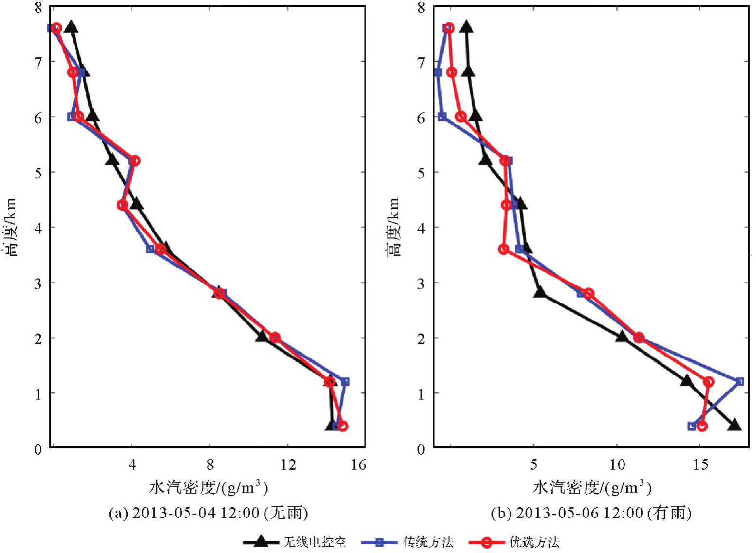
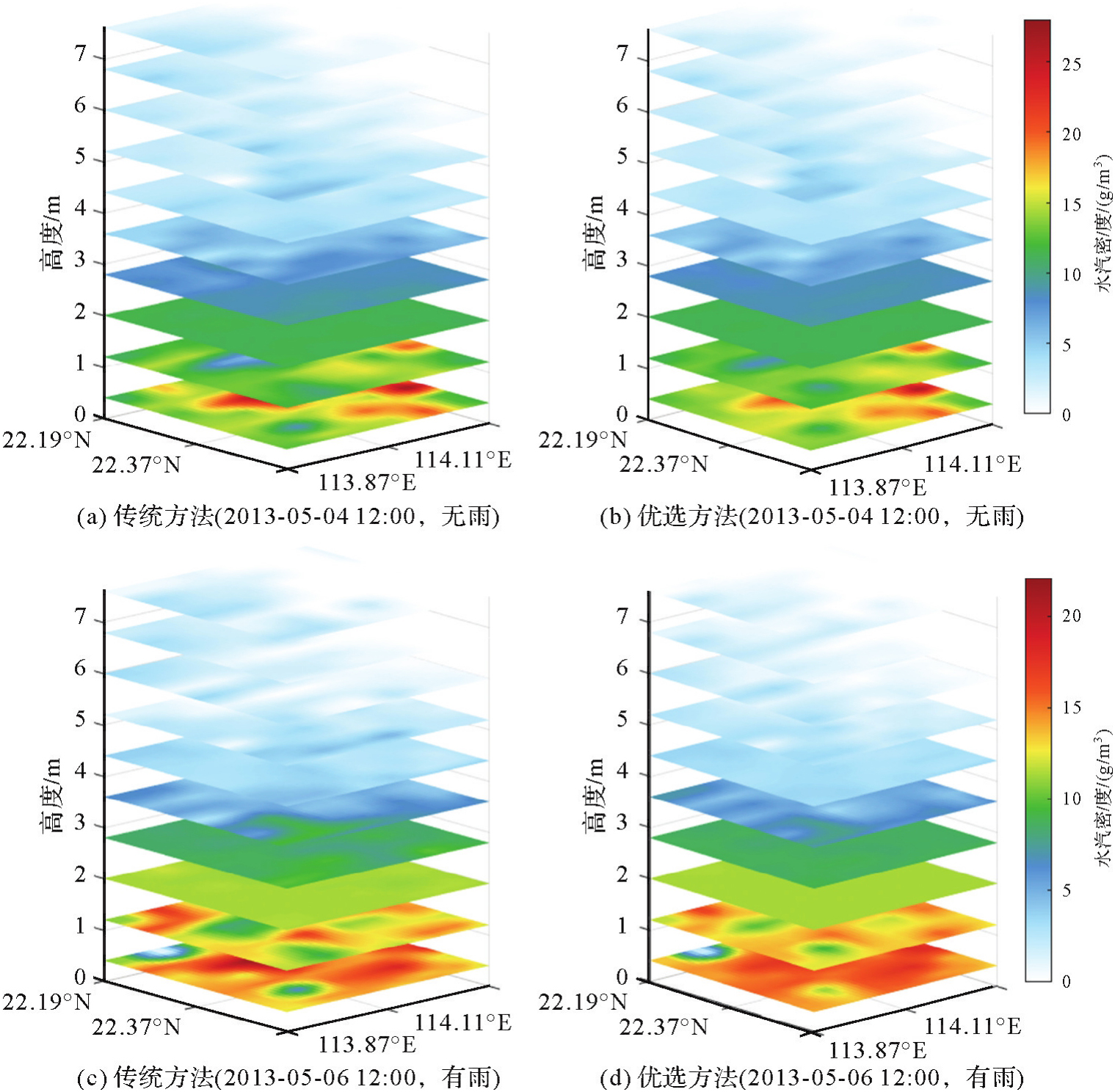
| [1] |
YAO Yibin, YANG Yuanxi, SUN Heping, et al. Geodesy discipline: progress and perspective[J]. Journal of Geodesy and Geoinformation Science, 2021, 4(4): 1-10.
|
| [2] |
TRZCINA E, ROHM W. Estimation of 3D wet refractivity by tomography, combining GNSS and NWP data: first results from assimilation of wet refractivity into NWP[J]. Quarterly Journal of the Royal Meteorological Society, 2019, 145(720): 1034-1051.
|
| [3] |
YAO Yibin, SUN Zhangyu, XU Chaoqian. Applicability of Bevis formula at different height levels and global weighted mean temperature model based on near-earth atmospheric temperature[J]. Journal of Geodesy and Geoinformation Science, 2020, 3(1): 1-11.
|
| [4] |
张克非, 李浩博, 王晓明, 等. 地基GNSS大气水汽探测遥感研究进展和展望[J]. 测绘学报, 2022, 51(7): 1172-1191. DOI: .
doi: 10.11947/j.AGCS.2022.20220149
|
|
ZHANG Kefei, LI Haobo, WANG Xiaoming, et al. Recent progresses and future prospectives of ground-based GNSS water vapor sounding[J]. Acta Geodaetica et Cartographica Sinica, 2022, 51(7): 1172-1191. DOI: .
doi: 10.11947/j.AGCS.2022.20220149
|
| [5] |
丁楠. 地基GNSS水汽层析关键技术研究[D]. 徐州: 中国矿业大学, 2018.
|
|
DING Nan. Research on the key technologies of ground based GNSS water vapor tomography[D]. Xuzhou: China University of Mining and Technology, 2018.
|
| [6] |
BRAUN J, ROCKEN C, MEERTENS C, et al. Development of a water vapor tomography system using low cost L1 GPS receivers[C]//Proceedings of the 9th ARM Science Team Meeting. San Antonio: US Department of Energy, 1999: 22-26.
|
| [7] |
FLORES A, RUFFINI G, RIUS A. 4D tropospheric tomography using GPS slant wet delays[J]. Annales Geophysicae, 2000, 18(2): 223-234.
|
| [8] |
赵庆志. 地基GNSS水汽反演关键技术研究及其应用[D]. 武汉: 武汉大学, 2017.
|
|
ZHAO Qingzhi. Studies on the key technologies in water vapor inversion using ground-based GNSS and its applications[D]. Wuhan: Wuhan University, 2017.
|
| [9] |
张文渊, 张书毕, 郑南山, 等. 联合GNSS/RS多源数据反演三维大气水汽分布研究[J]. 地球物理学报, 2022, 65(6): 1951-1964.
|
|
ZHANG Wenyuan, ZHANG Shubi, ZHENG Nanshan, et al. Study on the retrieval of 3D atmospheric water vapor distribution using GNSS and RS multi-source data[J]. Chinese Journal of Geophysics, 2022, 65(6): 1951-1964.
|
| [10] |
姚秀光, 郭金城, 严梦琪, 等. 基于地基GNSS观测数据的贵州高原地区水汽层析精度分析[J]. 大地测量与地球动力学, 2023, 43(11): 1162-1166.
|
|
YAO Xiuguang, GUO Jincheng, YAN Mengqi, et al. Accuracy analysis of water vapor chromatography in Guizhou Plateau based on ground-based GNSS observation data[J]. Journal of Geodesy and Geodynamic, 2023, 43(11): 1162-1166.
|
| [11] |
王昊, 丁楠, 张文渊, 等. GNSS水汽层析的自适应非均匀指数分层方法[J]. 测绘学报, 2022, 51(3): 327-339. DOI: .
doi: 10.11947/j.AGCS.2022.20210126
|
|
WANG Hao, DING Nan, ZHANG Wenyuan, et al. An adaptive non-uniform vertical stratification for GNSS water vapor tomography[J]. Acta Geodaetica et Cartographica Sinica, 2022, 51(3): 327-339. DOI: .
doi: 10.11947/j.AGCS.2022.20210126
|
| [12] |
张文渊, 戚铭心, 张书毕. 顾及水汽分布的非均匀离散化GNSS水汽层析精化方法[J]. 测绘学报, 2024, 53(12): 2282-2294. DOI: .
doi: 10.11947/j.AGCS.2024.20220534
|
|
ZHANG Wenyuan, QI Mingxin, ZHANG Shubi. A non-uniform discretization GNSS water vapor tomography refined method considering water vapor distributions[J]. Acta Geodaetica et Cartographica Sinica, 2024, 53(12): 2282-2294. DOI: .
doi: 10.11947/j.AGCS.2024.20220534
|
| [13] |
PERLER D, GEIGER A, HURTER F. 4D GPS water vapor tomography: new parameterized approaches[J]. Journal of Geodesy, 2011, 85(8): 539-550.
|
| [14] |
DING Nan, ZHANG Shubi, WU Suqin, et al. Adaptive node parameterization for dynamic determination of boundaries and nodes of GNSS tomographic models[J]. Journal of Geophysical Research: Atmospheres, 2018, 123(4): 1990-2003.
|
| [15] |
ZHAO Qingzhi, YAO Yibin, YAO Wanqiang. Troposphere water vapour tomography: a horizontal parameterised approach[J]. Remote Sensing, 2018, 10(8): 1241.
|
| [16] |
ZHANG Wenyuan, ZHANG Shubi, MOELLER G, et al. An adaptive-degree layered function-based method to GNSS tropospheric tomography[J]. GPS Solutions, 2023, 27(2): 67.
|
| [17] |
赵庆志, 姚宜斌, 罗亦泳. 附加辅助层析区域提高射线利用率的水汽反演方法[J]. 武汉大学学报(信息科学版), 2017, 42(9): 1203-1208, 1222.
|
|
ZHAO Qingzhi, YAO Yibin, LUO Yiyong. A method to improve the utilization of observation for water vapor tomography by adding assisted tomographic area[J]. Geomatics and Information Science of Wuhan University, 2017, 42(9): 1203-1208, 1222.
|
| [18] |
YAO Yibin, ZHAO Qingzhi. Maximally using GPS observation for water vapor tomography[J]. IEEE Transactions on Geoscience and Remote Sensing, 2016, 54(12): 7185-7196.
|
| [19] |
YAO Yibin, ZHAO Qingzhi, ZHANG Bao. A method to improve the utilization of GNSS observation for water vapor tomography[J]. Annales Geophysicae, 2016, 34(1): 143-152.
|
| [20] |
LIU Shangyi, ZHANG Kefei, WU Suqin, et al. An improved GNSS tropospheric tomographic model with an extended region and combining virtual signals[J]. Atmospheric Research, 2023, 287: 106703.
|
| [21] |
ASKNE J, NORDIUS H. Estimation of tropospheric delay for microwaves from surface weather data[J]. Radio Science, 1987, 22(3): 379-386.
|
| [22] |
BEVIS M, BUSINGER S, CHISWELL S, et al. GPS meteorology: mapping zenith wet delays onto precipitable water[J]. Journal of Applied Meteorology, 1994, 33(3): 379-386.
|
| [23] |
YAO Yibin, SUN Zhangyu, XU Chaoqian. Applicability of Bevis formula at different height levels and global weighted mean temperature model based on near-earth atmospheric temperature[J]. Journal of Geodesy and Geoinformation Science, 2020, 3(1): 1-11.
|
| [24] |
ROHM W. The ground GNSS tomography-unconstrained approach[J]. Advances in Space Research, 2013, 51(3): 501-513.
|
| [25] |
宋淑丽, 朱文耀, 丁金才, 等. 上海GPS网层析水汽三维分布改善数值预报湿度场[J]. 科学通报, 2005, 50(20): 2271-2277.
|
|
SONG Shuli, ZHU Wenyao, DING Jincai, et al. Improve the accuracy of the humidity field from numerical weather prediction model using the three-dimensional water vapor tomography result in Shanghai GNSS network[J]. Chinese Science Bulletin, 2005, 50(20): 2271-2277.
|
| [26] |
王维, 王解先. 基于代数重构技术的对流层水汽层析[J]. 计算机应用, 2011, 31(11): 3149-3151.
|
|
WANG Wei, WANG Jiexian. Ground-based GPS water vapor tomography based on algebraic reconstruction technique[J]. Journal of Computer Applications, 2011, 31(11): 3149-3151.
|
| [27] |
王维, 宋淑丽, 王解先, 等. 长三角地区多模GNSS斜路径观测分布及水汽仿真层析[J]. 测绘学报, 2016, 45(2): 164-169. DOI: .
doi: 10.11947/j.AGCS.2016.20140648
|
|
WANG Wei, SONG Shuli, W ANG Jiexian, et al. Distribution analysis of multi-GNSS slant delays and simulated water vapor tomography in Yangtze River Delta[J]. Acta Geodaetica et Cartographica Sinica, 2016, 45(2): 164-169. DOI: .
doi: 10.11947/j.AGCS.2016.20140648
|
| [28] |
CAO Yunchang, CHEN Yongqi, LI Pingwha. Wet refractivity tomography with an improved Kalman-filter method[J]. Advances in Atmospheric Sciences, 2006, 23(5): 693-699.
|
| [29] |
ZHAO Qingzhi, LI Zufeng, YAO Wanqiang, et al. An improved ridge estimation (IRE) method for troposphere water vapor tomography[J]. Journal of Atmospheric and Solar-Terrestrial Physics, 2020, 207: 105366.
|
| [30] |
CHANG K T. Introduction to geographic information systems[M]. Boston: McGraw-Hill, 2008.
|


 ), 蒋朵朵1, 姚宜斌2, 马智1, 马永杰1, 李浩杰1, 薛瑞瑞1