


测绘学报 ›› 2025, Vol. 54 ›› Issue (5): 937-949.doi: 10.11947/j.AGCS.2025.20240369
石岩1,2,3( ), 李诗逸1, 王达1(), 邓敏1,3, 汤仲安3,4
收稿日期:2024-09-05
修回日期:2025-04-11
出版日期:2025-06-23
发布日期:2025-06-23
通讯作者:
王达
E-mail:csu_shiy@csu.edu.cn;215001023@csu.edu.cn
作者简介:石岩(1988—),男,博士,教授,研究方向为地理大数据挖掘及其在国土空间规划、城市公共安全、智慧交通管控、地质灾害预警等领域的应用。 E-mail:csu_shiy@csu.edu.cn
基金资助:
Yan SHI1,2,3(), Shiyi LI1, Da WANG1(), Min DENG1,3, Zhong'an TANG3,4
Received:2024-09-05
Revised:2025-04-11
Online:2025-06-23
Published:2025-06-23
Contact:
Da WANG
E-mail:csu_shiy@csu.edu.cn;215001023@csu.edu.cn
About author:SHI Yan (1988—), male, PhD, professor, majors in geographical big data mining and its application of territorial spatial planning, urban public security, intelligent traffic management, geological disaster warning and so on. E-mail: csu_shiy@csu.edu.cn
Supported by:摘要:
地理空间数据挖掘旨在深入揭示多元地理要素的复杂分布规则与时空演化趋势。当前研究大多基于空间相关性依赖假设,缺乏对深层次空间因果关系的剖析,混杂的伪相关关系导致挖掘结果有偏甚至错误。本文基于因果推断理论,考虑空间邻域效应在因果关系中的影响作用,提出了一种顾及空间邻域效应的多元地理要素因果模式挖掘方法。首先,基于空间聚类算法自动建立适应地理要素分布密度的事务集;然后,融合空间邻域效应与贝叶斯网络建模思想,构建多元地理要素空间因果有向图结构;最后,基于后门准则实施干预运算,实现多元地理要素间因果效应的定量计算。试验采用深圳市和上海市城市设施空间分布数据进行实例分析,与空间关联模式挖掘方法的对比结果表明,本文方法剔除了混杂变量引起的空间伪相关关系,能够有效地得到不同类型城市功能设施间的有向因果关系与因果作用强度,更准确地揭示城市功能设施的局部集聚效应,为城市空间优化布局提供更可信的决策支持。
中图分类号:
石岩, 李诗逸, 王达, 邓敏, 汤仲安. 顾及空间邻域效应的多元地理要素因果模式挖掘方法[J]. 测绘学报, 2025, 54(5): 937-949.
Yan SHI, Shiyi LI, Da WANG, Min DENG, Zhong'an TANG. Methodology for mining causal patterns of multiple geographic elements by considering spatial neighborhood effects[J]. Acta Geodaetica et Cartographica Sinica, 2025, 54(5): 937-949.
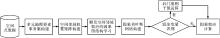
图1
本文策略"
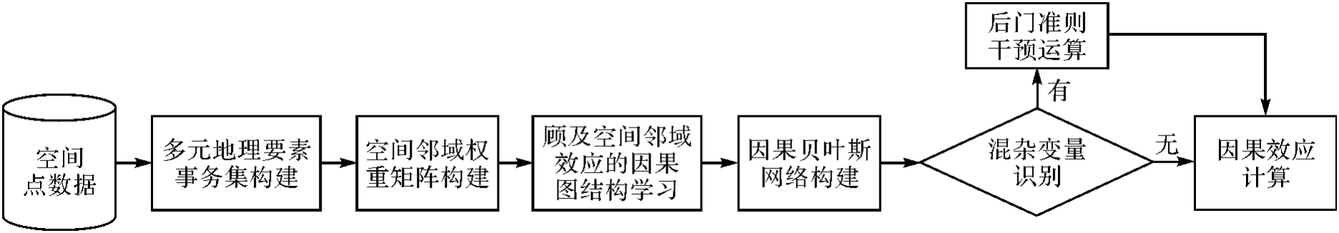
图2
多元地理要素因果模式挖掘事务集空间分区自适应构建"
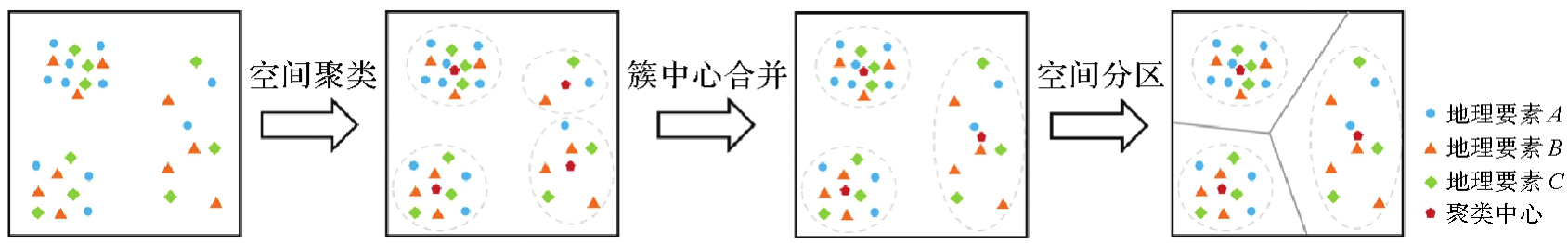
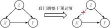
图3
消除混杂变量影响的干预运算"
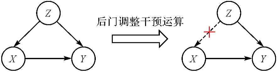
表1
POI类别信息"
| 一级类别 | 二级类别 |
|---|---|
| 学校 | 学校(中类) |
| 餐厅 | 中餐厅、快餐厅、外国餐厅 |
| 商超 | 商场、超级市场 |
| 酒店住宿 | 宾馆酒店、住宿服务相关 |
| 公交站点 | 公交车站、地铁站 |
| 娱乐场所 | 娱乐场所(中类) |
| 运动场馆 | 运动场馆(中类) |
表2
深圳市各类POI数量信息"
| POI类别 | 数量 |
|---|---|
| 学校 | 74 422 |
| 餐厅 | 7717 |
| 商超 | 7547 |
| 酒店住宿 | 6453 |
| 公交站点 | 4564 |
| 娱乐场所 | 4163 |
| 运动场馆 | 3393 |
表3
上海市各类POI数量信息"
| POI类别 | 数量 |
|---|---|
| 学校 | 85 085 |
| 餐厅 | 17 017 |
| 商超 | 12 829 |
| 酒店住宿 | 11 076 |
| 公交站点 | 8860 |
| 娱乐场所 | 7727 |
| 运动场馆 | 7632 |
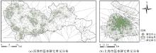
图4
基本研究单元划分结果"

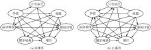
图5
城市功能设施集聚因果关系"
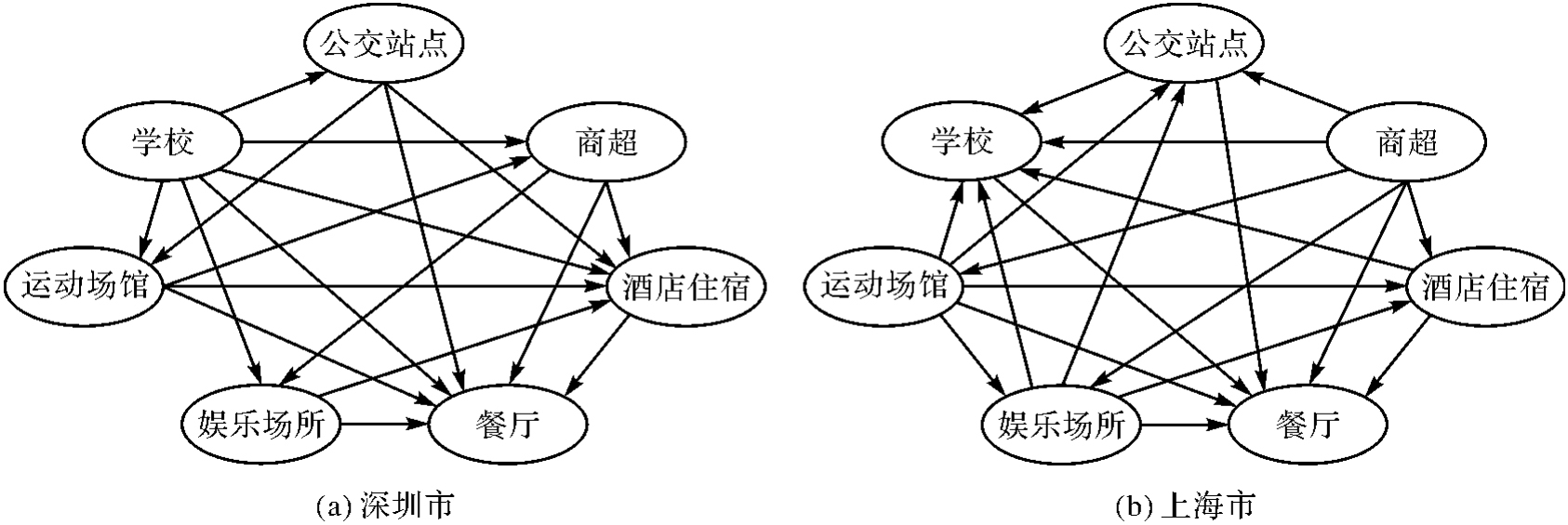
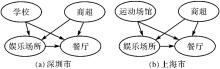
图6
城市功能设施集聚因果关系及其混杂变量示例"
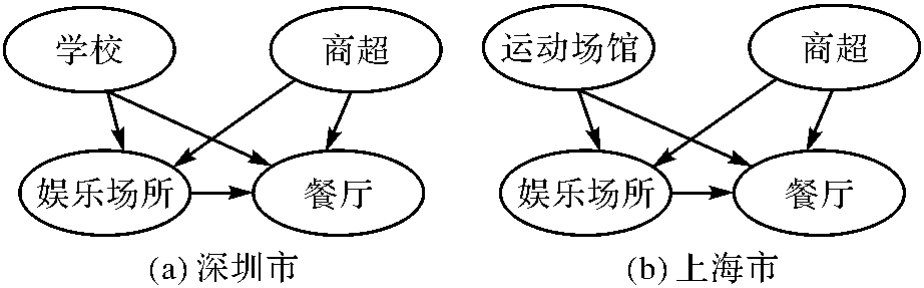
表4
深圳市城市功能设施集聚因果效应"
| 城市功能设施集聚因果关系 | P(Y=1|do(X=1)) | P(Y=1|do(X=0)) | 集聚因果效应 |
|---|---|---|---|
| {“商超”→“娱乐场所”} | 0.452 94 | 0.105 12 | 0.347 82 |
| {“商超”→“餐厅”} | 0.391 66 | 0.096 92 | 0.294 74 |
| {“娱乐场所”→“餐厅”} | 0.455 64 | 0.098 62 | 0.357 02 |
| {“学校”→“运动场馆”} | 0.330 69 | 0.167 54 | 0.163 15 |
| {“酒店住宿”→“餐厅”} | 0.402 28 | 0.159 99 | 0.242 29 |
| {“运动场馆”→“商超”} | 0.347 69 | 0.190 86 | 0.156 83 |
| {“运动场馆”→“餐厅”} | 0.304 39 | 0.131 00 | 0.173 39 |
表5
上海市城市功能设施集聚因果效应"
| 城市功能设施集聚因果关系 | P(Y=1|do(X=1)) | P(Y=1|do(X=0)) | 集聚因果效应 |
|---|---|---|---|
| {“商超”→“娱乐场所”} | 0.265 02 | 0.124 44 | 0.140 58 |
| {“商超”→“餐厅”} | 0.326 75 | 0.083 29 | 0.243 46 |
| {“娱乐场所”→“酒店住宿”} | 0.160 70 | 0.048 08 | 0.112 62 |
| {“娱乐场所”→“餐厅”} | 0.377 73 | 0.112 05 | 0.265 68 |
| {“酒店住宿”→“餐厅”} | 0.333 50 | 0.151 08 | 0.182 42 |
| {“运动场馆”→“娱乐场所”} | 0.394 30 | 0.132 07 | 0.262 23 |
| {“运动场馆”→“酒店住宿”} | 0.204 80 | 0.048 65 | 0.156 15 |
| {“运动场馆”→“餐厅”} | 0.328 40 | 0.132 64 | 0.195 76 |
图7
深圳市功能设施集聚显著因果关系空间分布"
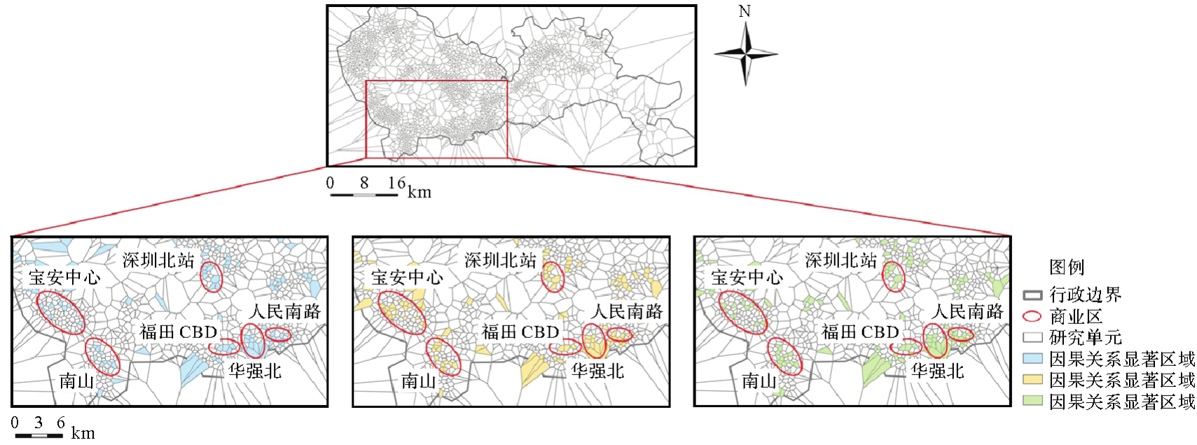
图8
上海市功能设施集聚显著因果关系空间分布"
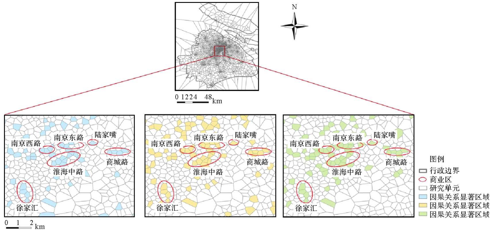

图9
深圳市城市功能设施空间关联与空间因果模式置信度对比"
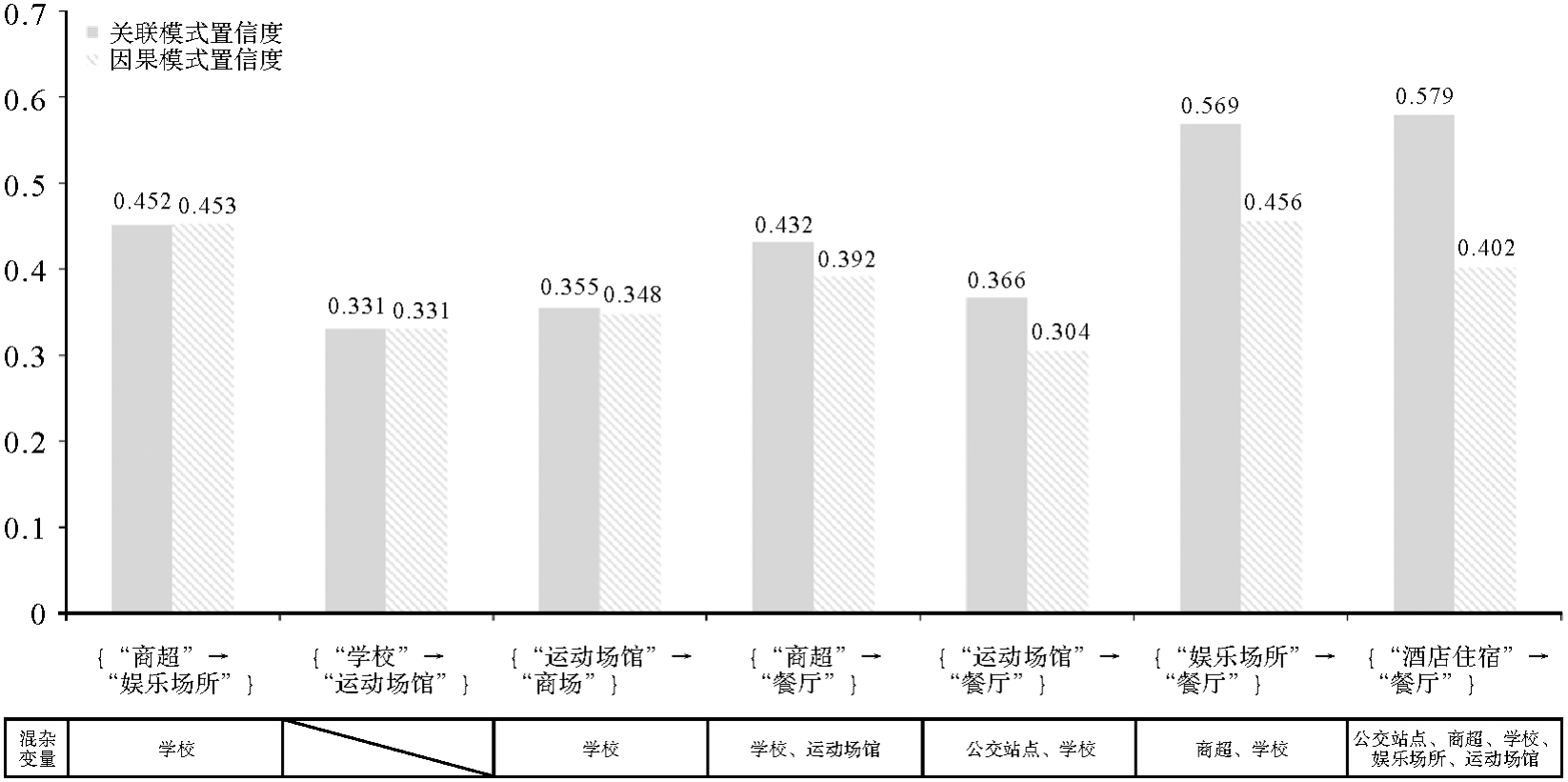
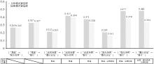
图10
上海市城市功能设施空间关联与空间因果模式置信度对比"
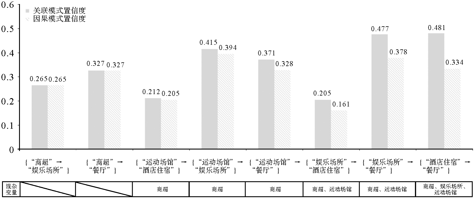
表6
不同空间距离阈值下上海市城市功能设施间的因果关系对比"
| 因果关系 | 100 | 300 | 500 | 700 | 900 |
|---|---|---|---|---|---|
| {“商超”→“公交站点”} | √ | √ | √ | √ | √ |
| {“商超”→“娱乐场所”} | √ | √ | √ | ||
| {“商超”→“酒店住宿”} | √ | √ | √ | √ | |
| {“商超”→“餐厅”} | √ | √ | √ | √ | √ |
| {“商超”→“学校”} | √ | √ | √ | √ | |
| {“商超”→“运动场馆”} | √ | √ | √ | ||
| {“运动场馆”→“娱乐场所”} | √ | √ | √ | ||
| {“运动场馆”→“餐厅”} | √ | √ | √ | √ | √ |
| {“运动场馆”→“酒店住宿”} | √ | √ | √ | √ | √ |
| {“运动场馆”→“学校”} | √ | √ | √ | √ | √ |
| {“运动场馆”→“公交站点”} | √ | √ | √ | √ | |
| {“酒店住宿”→“餐厅”} | √ | √ | √ | √ | √ |
| {“酒店住宿”→“学校”} | √ | ||||
| {“娱乐场所”→“餐厅”} | √ | √ | √ | √ | √ |
| {“娱乐场所”→“酒店住宿”} | √ | √ | √ | √ | √ |
| {“娱乐场所”→“学校”} | √ | √ | √ | √ | |
| {“娱乐场所”→“公交站点”} | √ | √ | √ | √ | |
| {“公交站点”→“学校”} | √ | √ | √ | ||
| {“公交站点”→“餐厅”} | √ | √ | √ | √ | √ |
| {“学校”→“餐厅”} | √ | √ | √ | √ | √ |
| {“学校”→“公交站点”} | √ | √ | |||
| {“学校”→“酒店住宿”} | √ | √ | √ | ||
| {“公交站点”→“酒店住宿”} | √ | √ | √ |
表7
上海市基于欧氏距离和路网距离聚类的因果关系对比"
| 因果关系 | 欧氏距离 | 路网距离 |
|---|---|---|
| {“商超”→“公交站点”} | √ | √ |
| {“商超”→“娱乐场所”} | √ | |
| {“商超”→“酒店住宿”} | √ | √ |
| {“商超”→“餐厅”} | √ | √ |
| {“商超”→“学校”} | √ | √ |
| {“商超”→“运动场馆”} | √ | |
| {“运动场馆”→“娱乐场所”} | √ | |
| {“运动场馆”→“餐厅”} | √ | √ |
| {“运动场馆”→“酒店住宿”} | √ | √ |
| {“运动场馆”→“学校”} | √ | √ |
| {“运动场馆”→“公交站点”} | √ | √ |
| {“酒店住宿”→“餐厅”} | √ | √ |
| {“酒店住宿”→“学校”} | √ | √ |
| {“娱乐场所”→“餐厅”} | √ | √ |
| {“娱乐场所”→“酒店住宿”} | √ | √ |
| {“娱乐场所”→“学校”} | √ | |
| {“娱乐场所”→“公交站点”} | √ | √ |
| {“学校”→“餐厅”} | √ | √ |
| {“公交站点”→“学校”} | √ | √ |
| {“公交站点”→“餐厅”} | √ | √ |
| {“公交站点”→“酒店住宿”} | √ |
| [1] |
刘耀林, 刘启亮, 邓敏, 等. 地理大数据挖掘研究进展与挑战[J]. 测绘学报, 2022, 51(7): 1544-1560. DOI .
doi: 10.11947/j.AGCS.2022.20220068 |
|
LIU Yaolin, LIU Qiliang, DENG Min, et al. Recent advance and challenge in geospatial big data mining[J]. Acta Geodaetica et Cartographica Sinica, 2022, 51(7): 1544-1560. DOI .
doi: 10.11947/j.AGCS.2022.20220068 |
|
| [2] | 邓敏, 蔡建南, 杨文涛, 等. 多模态地理大数据时空分析方法[J]. 地球信息科学学报, 2020, 22(1): 41-56. |
| DENG Min, CAI Jiannan, YANG Wentao, et al. Spatio-temporal analysis methods for multi-modal geographic big data[J]. Journal of Geo-information Science, 2020, 22(1): 41-56. | |
| [3] | SHEKHAR S, HUANG Yan. Discovering spatial co-location patterns: a summary of results[M]//Advances in spatial and temporal databases. Berlin: Springer, 2001: 236-256. |
| [4] |
蔡建南, 刘启亮, 徐枫, 等. 多层次空间同位模式自适应挖掘方法[J]. 测绘学报, 2016, 45(4): 475-485. DOI .
doi: 10.11947/j. AGCS.2016.20150337 |
|
CAI Jiannan, LIU Qiliang, XU Feng, et al. An adaptive method for mining hierarchical spatial co-location patterns[J]. Acta Geodaetica et Cartographica Sinica, 2016, 45(4): 475-485. DOI .
doi: 10.11947/j. AGCS.2016.20150337 |
|
| [5] | CAI Jiannan, LIU Qiliang, DENG Min, et al. Adaptive detection of statistically significant regional spatial co-location patterns[J]. Computers, Environment and Urban Systems, 2018, 68: 53-63. |
| [6] | 邓敏, 蔡建南, 何占军, 等. 地理空间关联模式挖掘的理论与方法[M]. 北京: 科学出版社, 2023. |
| DENG Min, CAI Jiannan, HE Zhanjun, et al. Theory and method of mining geo-spatial association patterns[M]. Beijing: Science Press, 2023. | |
| [7] | YU Wenhao, AI Tinghua, HE Yakun, et al. Spatial co-location pattern mining of facility points-of-interest improved by network neighborhood and distance decay effects[J]. International Journal of Geographical Information Science, 2017, 31(2): 280-296. |
| [8] | ANDRZEJEWSKI W, BOINSKI P. Efficient spatial co-location pattern mining on multiple GPUs[J]. Expert Systems with Applications, 2018, 93(3): 465-483. |
| [9] | CHEN Yimin, CHEN Xinyue, LIU Zihui, et al. Understanding the spatial organization of urban functions based on co-location patterns mining: a comparative analysis for 25 Chinese cities[J]. Cities, 2020, 97: 102563. |
| [10] | HE Zhanjun, DENG Min, XIE Zhong, et al. Discovering the joint influence of urban facilities on crime occurrence using spatial co-location pattern mining[J]. Cities, 2020, 99: 102612. |
| [11] | LI Ling, CHENG Jianquan, BANNISTER J, et al. Geographically and temporally weighted co-location quotient: an analysis of spatiotemporal crime patterns in greater Manchester[J]. International Journal of Geographical Information Science, 2022, 36(5): 918-942. |
| [12] | ZHI Guoqing, MENG Bin, LIN Hui, et al. Spatial co-location patterns between early COVID-19 risk and urban facilities: a case study of Wuhan, China[J]. Frontiers in Public Health, 2024, 11: 1293888. |
| [13] | BARREDO ARRIETA A, DÍAZ-RODRÍGUEZ N, DEL SER J, et al. Explainable artificial intelligence (XAI): concepts, taxonomies, opportunities and challenges toward responsible AI[J]. Information Fusion, 2020, 58: 82-115. |
| [14] | WU Chenwang, WANG Xiting, LIAN Defu, et al. A causality inspired framework for model interpretation[C]//Proceedings of the 29th ACM SIGKDD Conference on Knowledge Discovery and Data Mining. Long Beach: ACM Press, 2023: 2731-2741. |
| [15] | PEARL J. Causal inference in statistics: an overview[J]. Statistics Surveys, 2009, 3: 96-146. |
| [16] | 苏建宾, 陈都鑫, 郑东海, 等. 追索为什么?地球系统科学中的因果推理[J]. 中国科学:地球科学, 2023, 53(10): 2199-2216. |
| SU Jianbin, CHEN Dduxin, ZHENG Donghai et al. The insight of why: causal inference in Earth system science[J]. Scientia Sinica (Terrae), 2023, 53(10): 2199-2216. | |
| [17] | SPIRTES P, GLYMOUR C. An algorithm for fast recovery of sparse causal graphs[J]. Social Science Computer Review, 1991, 9(1): 62-72. |
| [18] | SHIMIZU S. Lingam: non-Gaussian methods for estimating causal structures[J]. Behaviormetrika, 2014, 41(1): 65-98. |
| [19] | ROSENBAUM P R, RUBIN D B. The central role of the propensity score in observational studies for causal effects[J]. Biometrika, 1983, 70(1): 41-55. |
| [20] | ABADIE A. Semiparametric difference-in-differences estimators[J]. The Review of Economic Studies, 2005, 72(1): 1-19. |
| [21] | PEARL J. Causality: models, reasoning, and inference[M]. Cambridge: Cambridge University Press, 2000. |
| [22] | PEARL J. Causal diagrams for empirical research[J]. Biometrika, 1995, 82(4): 669-688. |
| [23] | RUBIN D B. Estimating causal effects of treatments in randomized and nonrandomized studies[J]. Journal of Educational Psychology, 1974, 66(5): 688-701. |
| [24] | SPLAWA-NEYMAN J, DABROWSKA D M, SPEED T P. On the application of probability theory to agricultural experiments. essay on principles. section 9[J]. Statistical Science, 1990, 5(4): 465-472. |
| [25] | PEARL J. Causality[M]. Cambridge: Cambridge University Press, 2009. |
| [26] | PEARL J, GLYMOUR M, JEWELL N P. Causal inference in statistics: a primer[M]. John Wiley & Sons, 2016. |
| [27] | GRANGER C W. Investigating causal relations by econometric models and cross-spectral methods[J]. Econometrica, 1969, 37(3): 424-438. |
| [28] | GRANGER C W. Testing for causality: a personal viewpoint[J]. Journal of Economic Dynamics and Control, 1980, 2(1): 329-352. |
| [29] | SUGIHARA G, MAY R, YE Hao, et al. Detecting causality in complex ecosystems[J]. Science, 2012, 338(6106): 496-500. |
| [30] | XIAO Zhixuan, LI Chengyi, PAN Shihua, et al. Exploring the spatial impact of multisource data on urban vitality: a causal machine learning method[J]. Wireless Communications and Mobile Computing, 2022, 2022(1): 5263376. |
| [31] | CHEN Yimin, CHEN Jing, ZHAO Shuai, et al. Inferring the heterogeneous effect of urban land use on building height with causal machine learning[J]. GIScience & Remote Sensing, 2024, 61(1): 2321695. |
| [32] | CHEN Ziyue, XIE Xiaoming, CAI Jun, et al. Understanding meteorological influences on PM2.5 concentrations across China: a temporal and spatial perspective[J]. Atmospheric Chemistry & Physics, 2018, 18(8): 5343-5358. |
| [33] | GAO Bingbo, YANG Jianyu, CHEN Ziyue, et al. Causal inference from cross-sectional earth system data with geographical convergent cross mapping[J]. Nature Communications, 2023, 14(1): 5875. |
| [34] | ANKERST M, BREUING M M, KRIEGEL H P, et al. OPTICS: ordering points to identify the clustering structure[J]. ACM SIGMOD Record, 1999, 28(2): 49-60. |
| [35] | AKBARI K, WINTER S, TOMKO M. Spatial causality: a systematic review on spatial causal inference[J]. Geographical Analysis, 2023, 55(1): 56-89. |
| [36] | DIGITALE J C, MARTIN J N, GLYMOUR M M. Tutorial on directed acyclic graphs[J]. Journal of Clinical Epidemiology, 2022, 142: 264-267. |
| [37] | TENNANT P W G, MURRAY E J, ARNOLD K F, et al. Use of directed acyclic graphs (DAGs) to identify confounders in applied health research: review and recommendations[J]. International Journal of Epidemiology, 2021, 50(2): 620-632. |
| [38] | PETERS J, JANZING D, SCHÖLKOPF B. Elements of causal inference: foundations and learning algorithms[M]. Cambridge: The MIT Press, 2017. |
| [39] | ZHENG Xun, DAN Chen, ARAGAM B, et al. Learning sparse nonparametric dags[C]//Proceedings of 2020 International Conference on Artificial Intelligence and Statistics. [S.l.]: IEEE, 2020: 3414-3425. |
| [40] |
王靖涵, 艾廷华, 吴昊, 等. 基于图结构的空间同位模式挖掘[J]. 测绘学报, 2024, 53(4): 724-735. DOI .
doi: 10.11947/j. AGCS.2024.20230012 |
|
WANG Jinghan, AI Tinghua, WU Hao, et al. Spatial co-location pattern mining based on graph structure[J]. Acta Geodaetica et Cartographica Sinica, 2024, 53(4): 724-735. DOI .
doi: 10.11947/j. AGCS.2024.20230012 |
|
| [41] | YU Wenhao. Spatial co-location pattern mining for location-based services in road networks[J]. Expert Systems with Applications, 2016, 46(3): 324-335. |
| [42] | TRAN V, WANG Lizhen, CHEN Hongmei, et al. MCHT: a maximal clique and hash table-based maximal prevalent co-location pattern mining algorithm[J]. Expert Systems with Applications, 2021, 175: 114830. |
| [43] | 卢雨蓉, 邓建锋, 韩贵锋, 等. 城市公园的多维可达性动态评估研究[J]. 中国园林, 2022, 38(5): 92-97. |
| LU Yurong, DENG Jianfeng, HAN Guifeng, et al. Research on dynamic evaluation of multidimensional accessibility to urban park[J]. Chinese Landscape Architecture, 2022, 38(5): 92-97. |
| [1] | 吴明光, 成梓铭. 顾及使用场景的绿色地图颜色生成方法研究[J]. 测绘学报, 2026, 55(3): 390-403. |
| [2] | 杨敏, 马宏然, 孔博, 刘鹏程, 艾廷华. 基于预训练模型的矢量海岸线形态模式判别方法[J]. 测绘学报, 2026, 55(3): 404-414. |
| [3] | 禹文豪, 曾子怡, 张一帆, 钱海忠. 融合欧氏空间邻近与拓扑邻接信息预训练模型的路网网格模式[J]. 测绘学报, 2026, 55(3): 415-424. |
| [4] | 禄小敏, 张志义, 闫浩文, 何毅, 苏小宁. 融合深度图信息最大化和多层感知机的建筑物群组模式识别方法[J]. 测绘学报, 2026, 55(3): 425-438. |
| [5] | 成晓强, 赵家威, 刘鹏程. 基于距离-相似性隐喻的空间交互可视化[J]. 测绘学报, 2026, 55(3): 536-547. |
| [6] | 王泽矫, 向隆刚, 王猛, 王兴娟, 刘清. 融合层级特征与多样化注意力的道路面与中心线协同提取网络[J]. 测绘学报, 2026, 55(3): 548-563. |
| [7] | 徐智邦. 实体城市的多层次边界识别、模式分析与扩张模拟[J]. 测绘学报, 2026, 55(3): 566-566. |
| [8] | 冉耘博, 杨雪, 周文豪, 吴承恩, 周宝定, 唐炉亮, 李清泉. 多维偏好增强型对抗深度强化学习驱动的行人路径规划[J]. 测绘学报, 2026, 55(2): 191-205. |
| [9] | 王立增, 程诗奋, 杨一涛, 王培晓, 陆锋. 局部-全局联合感知的时空自适应交通集成预测方法[J]. 测绘学报, 2026, 55(2): 206-221. |
| [10] | 王少华, 梁浩健, 苏澄, 徐大川, 周亮, 秦昆. 耦合时空大数据和人工智能的城市设施配置优化研究进展与展望[J]. 测绘学报, 2026, 55(2): 222-235. |
| [11] | 付晓, 朱司蕊, 厉旭东, 闾国年. 面向长距离通勤场景的城市垂直起降场布局优化方法[J]. 测绘学报, 2026, 55(2): 236-248. |
| [12] | 郭军豪, 吴明治, 王培晓, 张恒才. 一种面向定点稀疏轨迹的密度聚类停留点识别方法[J]. 测绘学报, 2026, 55(2): 249-260. |
| [13] | 李冠男. 道路实景三维模型自动构建方法[J]. 测绘学报, 2026, 55(2): 378-378. |
| [14] | 刘鹏程, 成晓强, 肖天元, 杨敏, 艾廷华. 一种面向地图综合建筑多边形化简的Transformer模型[J]. 测绘学报, 2026, 55(1): 124-137. |
| [15] | 贺彪, 林浩嘉, 郭仁忠, 蒯希, 马丁, 张琛. 基于视觉感知的三维空间相似关系量化计算[J]. 测绘学报, 2026, 55(1): 138-153. |
| 阅读次数 | ||||||
|
全文 |
|
|||||
|
摘要 |
|
|||||