


测绘学报 ›› 2026, Vol. 55 ›› Issue (1): 154-168.doi: 10.11947/j.AGCS.2026.20250271
李维炼1( ), 冉晴晴1, 党沛1(), 朱军1, 朱庆1, 张恒2
收稿日期:2025-07-08
修回日期:2025-11-25
出版日期:2026-02-13
发布日期:2026-02-13
通讯作者:
党沛
E-mail:vgewilliam@163.com;dangpei@my.swjtu.edu.cn
作者简介:李维炼(1993—),男,博士,副研究员,研究方向为虚拟地理环境与三维可视化。E-mail:vgewilliam@163.com
基金资助:
Weilian LI1(), Qingqing RAN1, Pei DANG1(), Jun ZHU1, Qing ZHU1, Heng ZHANG2
Received:2025-07-08
Revised:2025-11-25
Online:2026-02-13
Published:2026-02-13
Contact:
Pei DANG
E-mail:vgewilliam@163.com;dangpei@my.swjtu.edu.cn
About author:LI Weilian (1993—), male, PhD, associate researcher, majors in virtual geographical environment and 3D visualization. E-mail: vgewilliam@163.com
Supported by:摘要:
地下车站内部设施通过物理连接、功能依赖和信息交互紧密耦合,这种耦合关系在洪水侵袭中呈现显著的级联效应,一旦某一关键设施受损,便可引发系统性风险。现有洪水脆弱性评估方法将各个设施视为独立单元,忽略了设施间的耦合作用关系和风险传导机制,难以准确刻画洪水对地下车站设施的破坏路径。因此,本文利用知识图谱(KG)语义关联和大语言模型(LLMs)的上下文推理能力,提出了一种耦合LLMs-KG的地下车站设施洪水脆弱性级联效应分析方法。首先,构建“对象-行为-状态”三域关联的地下车站设施知识图谱;其次,建立洪水演进-设施构件耦合的元胞自动机计算模型;然后,利用知识图谱约束大语言模型实现地下车站设施洪水脆弱性评估和级联效应推理;最后,选取北京市大兴区某大型地下车站为研究对象,结合DeepSeek-R1系列模型开展案例分析。结果表明,本文方法能够准确识别洪水作用下地下车站设施空间、功能属性变化及传播路径,推理过程具有良好的稳健性与可解释性。与专家预设基准级联路径相比,本文方法在节点匹配率和顺序匹配度方面呈现较高的准确性与逻辑一致性,相关成果能够为地下车站洪水针对性应急策略制定和系统韧性提升提供重要科学支撑。
中图分类号:
李维炼, 冉晴晴, 党沛, 朱军, 朱庆, 张恒. 耦合LLMs-KG的地下车站设施洪水脆弱性级联效应分析方法[J]. 测绘学报, 2026, 55(1): 154-168.
Weilian LI, Qingqing RAN, Pei DANG, Jun ZHU, Qing ZHU, Heng ZHANG. A coupled LLMs-KG method for cascading flood vulnerability analysis of underground station facilities[J]. Acta Geodaetica et Cartographica Sinica, 2026, 55(1): 154-168.
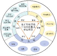
图1
洪水作用下地下车站设施三域关联集成表达模型"
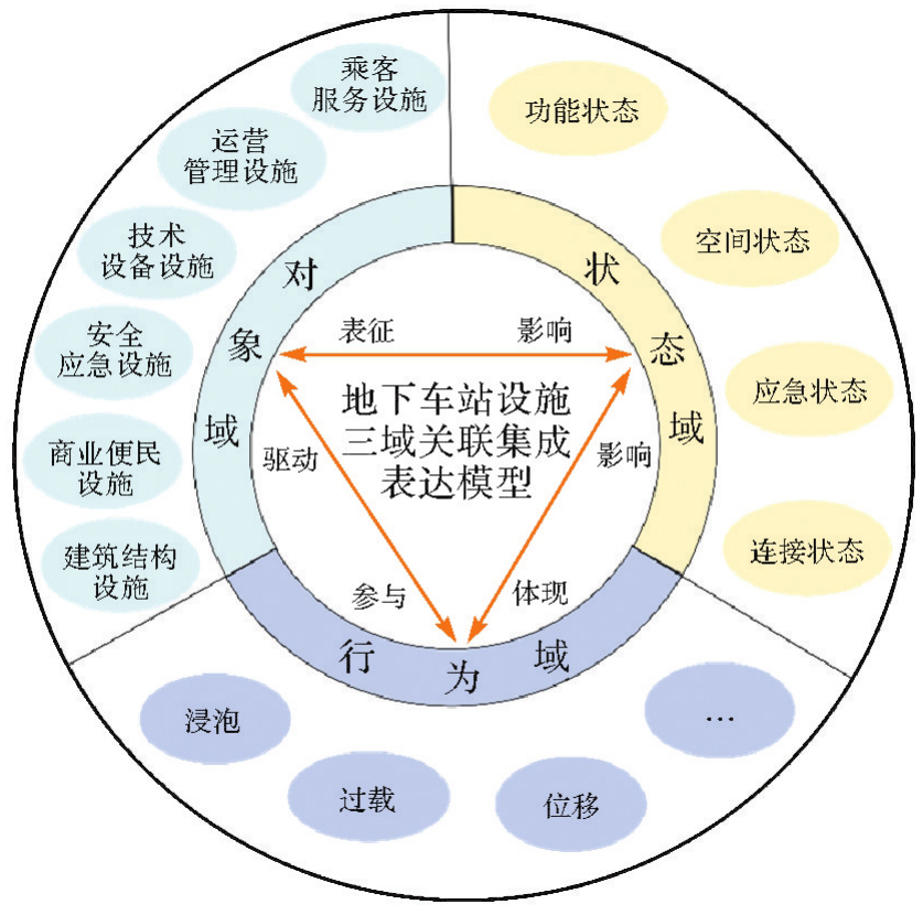
表1
地下车站设施分类与功能属性"
| 设施类别 | 功能属性 |
|---|---|
| 乘客服务设施 | 提供乘客通行、购票、候车、信息指引等服务 |
| 运营管理设施 | 支撑列车调度、设备监控、数据传输与能源供应 |
| 技术设备设施 | 实现排水、消防、温控、列车运行等关键技术功能 |
| 安全应急设施 | 提供紧急响应能力,保障人员安全与关键设备功能延续性 |
| 商业便民设施 | 提升车站服务多样性,间接影响客流分布与应急疏散路径规划 |
| 建筑结构设施 | 构成车站物理空间骨架 |
表2
设施间耦合关系与级联效应机制"
| 关系类型 | 说明 | 级联效应机制 |
|---|---|---|
| 物理连接 | 设施间的刚性结构关联 | 通过结构破坏直接引发洪水渗透或力学失效,形成物理层面的级联传播路径 |
| 功能依赖 | 设施间的能量或功能传递依赖 | 通过功能中断触发下游设施的连锁失效,形成能量流或控制流的级联效应 |
| 信息交互 | 设施间的监测与控制反馈 | 通过信息误传或延迟导致决策失误,间接放大洪水风险 |
| 空间邻近 | 设施间的地理分布关联 | 通过洪水扩散路径影响周边设施,形成空间层面的级联传播 |

图2
地下车站设施知识图谱实例化映射"
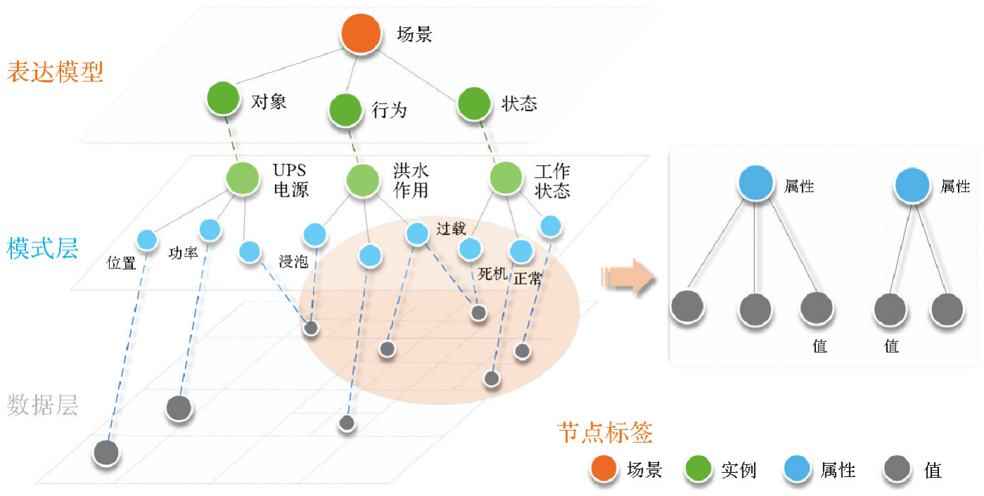
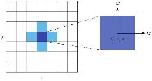
图3
洪水元胞自动机结构和Von Nuemann邻元类型"
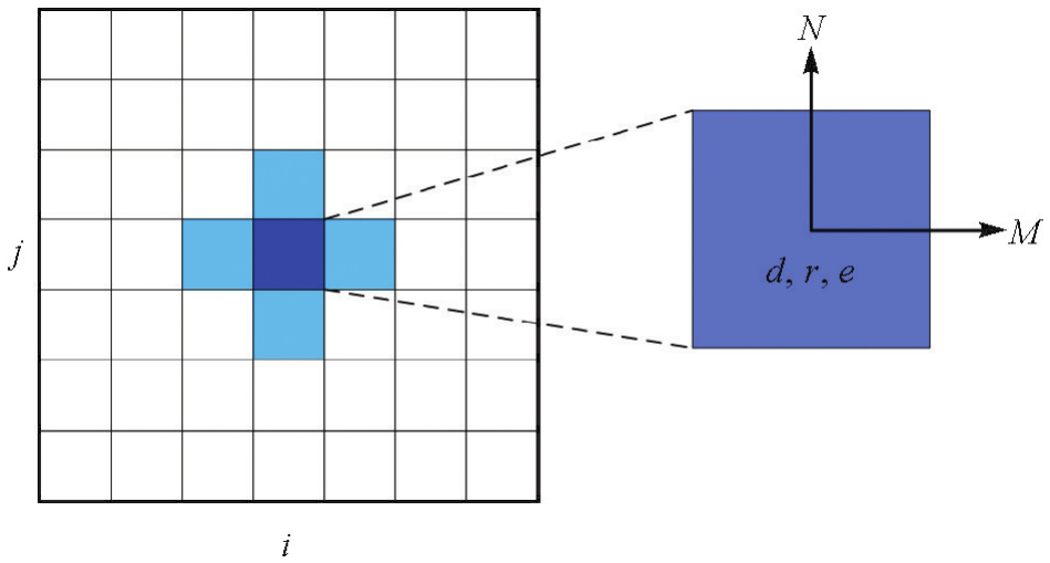
表3
糙率取值范围"
| 糙率分区 | 参数取值范围 | 观测糙率值 |
|---|---|---|
| 硬质区域 | 0.015~0.035 | 0.025 |
| 田地 | 0.05~0.15 | 0.10 |
| 树林 | 0.08~0.15 | 0.12 |
| 草地 | 0.03~0.08 | 0.05 |
| 河槽 | 0.02~0.05 | 0.03 |
| 卵石滩地 | 0.04~0.10 | 0.07 |
图4
洪水演进-设施构件相互作用及耦合流程"

表4
多维损害评估机制分级标准"
| 级别 | 一般定义 | 组件级别 | 子系统级别 | 系统级别 |
|---|---|---|---|---|
| L0无明显损坏 | 水深过浅,不会影响结构或功能。该实体仍保持在其设计运行状态。 | •部件完好无损,无物理变形 •与洪水接触极少或没有接触 •性能参数在设计限值范围 •浸泡时间≤0.5 h | •所有关键组件完好无损,未受洪水影响 •组件间连接正常(接点处无水接触) •子系统功能保持稳定,运行参数正常 | •整体系统结构稳定,未受影响所有子系统接口功能正常 •系统承载力和运行能力保持在设计水平 |
| L1轻微损坏 | 有少量进水或表面污损,但无基本功能损伤。经过快速、简单的维修后可回复全部功能。 | •元件/表面轻微受潮或污损,无明显变形 •性能参数略有波动,但仍在可接受范围内 •浸泡时间0.5~2 h | •若干关键组件受到轻微影响或连接略松动 •性能略有下降,但子系统仍能满足基本功能要求 | •整体系统仍保持功能正常,尽管安全余量略有降低 •局部维护可及时恢复全部设计容量 |
| L2中等损害 | 水深或浸泡时间导致结构或运行性能明显下降。需要进行中等程度的修复以恢复至正常状态。 | •部件出现局部材料退化、轻微变形或部分损坏 •性能参数明显下降,需要计划性维护 •浸泡时间2~6 h | •子系统的多个关键部件出现明显的性能下降 •部分功能受限(如,效率减半)或需要采取临时措施以维持运行 | •系统功能明显下降 •需要在子系统层面进行中等程度的维修或部件更换才能恢复至正常服务级别 |
| L3严重损坏 | 高水深或长时间浸泡会导致严重的结构和功能损坏,需要进行重大维修或部分重建。 | •部件出现明显的结构变形、材料损失或故障 •性能参数严重偏离设计值 •浸泡时间6~12 h | •关键子系统组件严重损坏,部分功能完全丧失 •子系统运行受到严重干扰或停止 | •系统功能明显下降 •需要在子系统层面进行中等程度的维修或部件更换才能恢复至正常服务级别 |
| L4彻底失效 | 核心结构或关键设备无法运作,系统失去所有功能。 | •部件彻底损坏,无法修复,无残留功能剩余 •浸泡时间≥12 h | 核心子系统组件完全失败 •子系统完全无法运行,无法执行其设计功能 | •系统几乎完全无法运行 •需要全面重建或长期修复才能恢复运行能力 |
图5
级联传播路径"

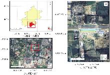
图6
案例区域"

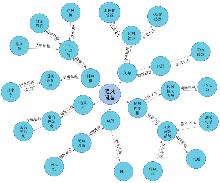
图7
地下车站通风设施知识图谱"
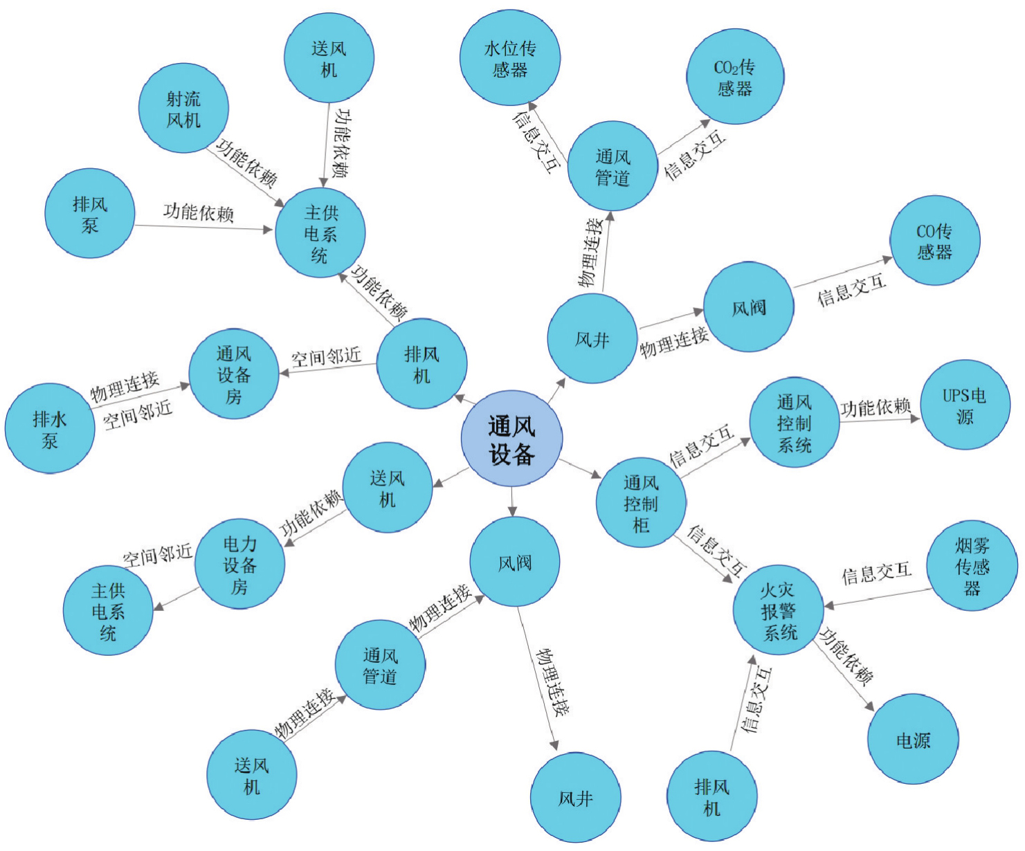
表5
地下车站实体"
| 设施类别 | 核心实体数量 | 部分实体 | 脆弱性关联 |
|---|---|---|---|
| 乘客服务设施 | 43 | 自动扶梯、垂直电梯、导向标识、照明系统 | 洪水浸泡导致停运,间接影响疏散效率 |
| 运营管理设施 | 52 | 信号系统、通信设备、UPS电源、监控系统 | 关键能源与控制节点,失效引发系统级联 |
| 技术设备设施 | 86 | 排水泵、暖通空调、轨道设备、配电柜 | 直接暴露于洪水环境,功能失效触发连锁反应 |
| 安全应急设施 | 33 | 防淹门、应急照明、消防栓、紧急疏散通道 | 防御性设施,失效加剧洪水风险 |
| 商业便民设施 | 11 | 自动售货机、充电桩、行李寄存柜、公共电话 | 间接影响客流分布,非关键级联节点 |
| 建筑结构设施 | 105 | 主体结构、防水层、基坑支护、防火分区隔墙 | 基础设施,损坏导致全局稳定性下降 |
表6
设施间级联关系"
| 关系类型 | 关系数量 | 实体 | 级联效应路径 |
|---|---|---|---|
| 物理连接 | 512 | 排水泵—防水层 | 防水层破损→泵房进水→排水泵失效→积水扩散 |
| 功能依赖 | 603 | UPS电源—信号系统 | UPS失效→信号系统断电→列车停运→乘客滞留 |
| 信息交互 | 247 | 水位传感器—泵站控制 | 传感器误报→排水泵未启动→积水超阈值→防淹门关闭 |
| 空间邻近 | 67 | 出入口坡道—站厅设备 | 洪水涌入→配电柜淹没→电力瘫痪 |
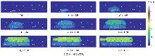
图8
洪水模拟结果及构件分布"

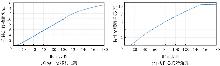
图9
构件位移及旋转结果"
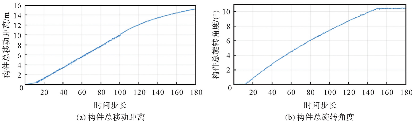

图10
构件功能变化次数"
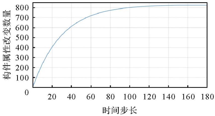
图11
部分时间步长实体属性变化情况"
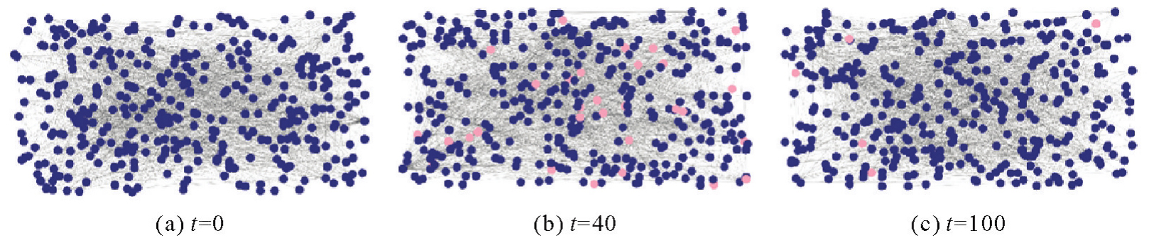
图12
案例区域部分实体属性变化情况"

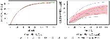
图13
渐进式干扰关系下构件属性改变数量对比"


图14
DeepSeek-R1不同模型规模的推理性能影响"

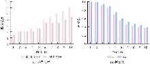
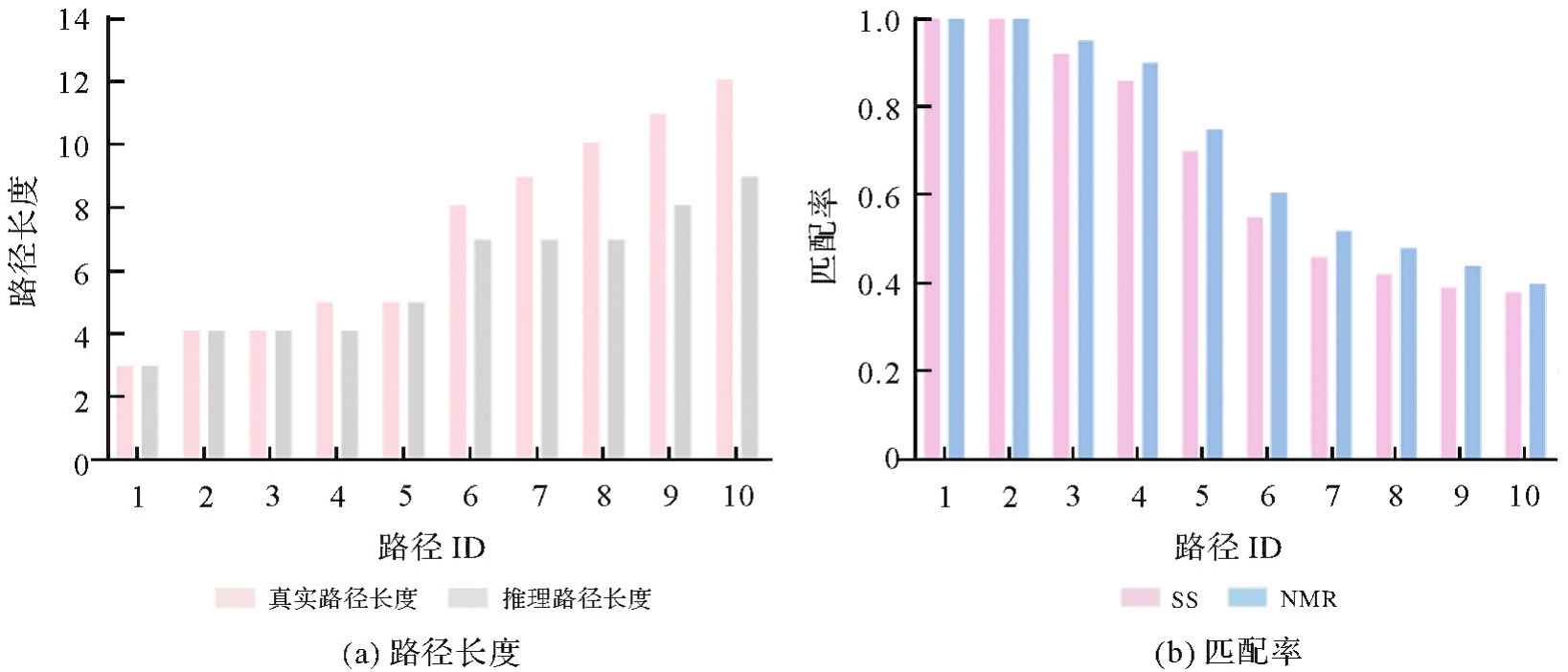
图15
基于NMR与SS指标的模型推理结果与专家路径一致性对比"
| [1] | 卢春房, 卢炜. 综合立体交通运输体系发展策略[J]. 铁道学报, 2022, 44(1): 1-7. |
| LU Chunfang, LU Wei. Development strategies of comprehensive stereoscopic transportation system[J]. Journal of the China Railway Society, 2022, 44(1): 1-7. | |
| [2] | 陈湘生, 付艳斌, 陈曦, 等. 地下空间施工技术进展及数智化技术现状[J]. 中国公路学报, 2022, 35(1): 1-12. |
| CHEN Xiangsheng, FU Yanbin, CHEN Xi, et al. Progress in underground space construction technology and technical challenges of digital intelligence[J]. China Journal of Highway and Transport, 2022, 35(1): 1-12. | |
| [3] | 王同军, 马伟斌, 王勇. 京张高铁八达岭长城地下车站建造及运营关键技术[J]. 隧道建设(中英文), 2023, 43(1): 1-16. |
| WANG Tongjun, MA Weibin, WANG Yong. Key technologies for construction and operation of Badaling great wall underground station on Beijing-Zhangjiakou high-speed railway[J]. Tunnel Construction, 2023, 43(1): 1-16. | |
| [4] | 沈智, 李飞, 刘红良, 等. 京张高铁地下站隧智能展示技术的探索与实践[J]. 铁路计算机应用, 2023, 32(2): 47-52. |
| SHEN Zhi, LI Fei, LIU Hongliang, et al. Intelligent display technology of Beijing-Zhangjiakou high-speed railway underground station tunnel[J]. Railway Computer Application, 2023, 32(2): 47-52. | |
| [5] | LI Weilian, HAUNERT J H, KNECHTEL J, et al. Social media insights on public perception and sentiment during and after disasters: the European floods in 2021 as a case study[J]. Transactions in GIS, 2023, 27(6): 1766-1793. |
| [6] | ZHU Jun, DANG Pei, CAO Yungang, et al. A flood knowledge-constrained large language model interactable with GIS: enhancing public risk perception of floods[J]. International Journal of Geographical Information Science, 2024, 38(4): 603-625. |
| [7] |
胡亚, 朱军, 李维炼, 等. 移动VR洪水灾害场景构建优化与交互方法[J]. 测绘学报, 2018, 47(8): 1123-1132. DOI: .
doi: 10.11947/j.AGCS.2018.20180114 |
|
HU Ya, ZHU Jun, LI Weilian, et al. A construction optimization and interaction method for flood disaster scenes based on mobile VR[J]. Acta Geodaetica et Cartographica Sinica, 2018, 47(8): 1123-1132. DOI: .
doi: 10.11947/j.AGCS.2018.20180114 |
|
| [8] | 乔欢. 暴雨情景下深基坑工程灾害风险评价研究[D]. 武汉: 武汉理工大学, 2020. |
| QIAO Huan. Research on disaster risk assessment of deep foundation pit under rainstorm environment[D]. Wuhan: Wuhan University of Technology, 2020. | |
| [9] | 周清华, 杨璟林, 李纯, 等. 京张高铁八达岭地下站及隧道工程信息模型一致性表达[J]. 铁路计算机应用, 2022, 31(10): 26-32. |
| ZHOU Qinghua, YANG Jinglin, LI Chun, et al. Consistent expression of information model of Badaling underground station and tunnel engineering[J]. Railway Computer Application, 2022, 31(10): 26-32. | |
| [10] | ALABBAD Y, MOUNT J, CAMPBELL A M, et al. Assessment of transportation system disruption and accessibility to critical amenities during flooding: Iowa case study[J]. Science of the Total Environment, 2021, 793: 148476. |
| [11] | GUIMARÃES L F, BATTEMARCO B P, OLIVEIRA A K B, et al. A new approach to assess cascading effects of urban floods[J]. Energy Reports, 2021, 7: 8357-8367. |
| [12] | SELVAM R A, ANTONY JEBAMALAI A R. Application of the analytical hierarchy process (AHP) for flood susceptibility mapping using GIS techniques in Thamirabarani river basin, Srivaikundam region, Southern India[J]. Natural Hazards, 2023, 118(2): 1065-1083. |
| [13] | LÖWE R, BÖHM J, JENSEN D G, et al. U-FLOOD-Topographic deep learning for predicting urban pluvial flood water depth[J]. Journal of Hydrology, 2021, 603: 126898. |
| [14] | 朱军, 尹灵芝, 曹振宇, 等. 时空过程网络可视化模拟与分析服务:以溃坝洪水为例[J]. 地球信息科学学报, 2015, 17(2): 215-221. |
| ZHU Jun, YIN Lingzhi, CAO Zhenyu, et al. Network simulation and visual analysis of spatiotemporal process: a case study of dam-break flood routing[J]. Journal of Geo-information Science, 2015, 17(2): 215-221. | |
| [15] | MA Bingyan, WU Zening, HU Caihong, et al. Process-oriented SWMM real-time correction and urban flood dynamic simulation[J]. Journal of Hydrology, 2022, 605: 127269. |
| [16] |
赖广陵, 童晓冲, 张勇, 等. 基于六边形格网的城市内涝洪水演进方法研究[J]. 测绘学报, 2016, 45(S1): 144-151. DOI: .
doi: 10.11947/j.AGCS.2016.F018 |
|
LAI Guangling, TONG Xiaochong, ZHANG Yong, et al. Research on the method of urban waterlogging flood routing based on hexagonal grid[J]. Acta Geodaetica et Cartographica Sinica, 2016, 45(S1): 144-151. DOI: .
doi: 10.11947/j.AGCS.2016.F018 |
|
| [17] | 沈定涛, 王结臣, 张煜, 等. 一种面向海量数字高程模型数据的洪水淹没区快速生成算法[J]. 测绘学报, 2014, 43(6): 645-652. |
| SHEN Dingtao, WANG Jiechen, ZHANG Yu, et al. A quick flood inundation algorithm based on massive DEM data[J]. Acta Geodaetica et Cartographica Sinica, 2014, 43(6): 645-652. | |
| [18] | YIN Yunzhu, VAL D V, ZOU Qingping, et al. Resilience of critical infrastructure systems to floods: a coupled probabilistic network flow and LISFLOOD-FP model[J]. Water, 2022, 14(5): 683. |
| [19] |
杨元喜. 地理空间数字孪生与时空智能[J]. 测绘学报, 2025, 54(2): 213-220. DOI: .
doi: 10.11947/j.AGCS.2025.20240515 |
|
YANG Yuanxi. Digital twin and spatio-temporal intelligence of geospatial information system[J]. Acta Geodaetica et Cartographica Sinica, 2025, 54(2): 213-220. DOI: .
doi: 10.11947/j.AGCS.2025.20240515 |
|
| [20] |
蒋秉川, 万刚, 许剑, 等. 多源异构数据的大规模地理知识图谱构建[J]. 测绘学报, 2018, 47(8): 1051-1061. DOI: .
doi: 10.11947/j.AGCS.2018.20180113 |
|
JIANG Bingchuan, WAN Gang, XU Jian, et al. Geographic knowledge graph building extracted from multi-sourced heterogeneous data[J]. Acta Geodaetica et Cartographica Sinica, 2018, 47(8): 1051-1061. DOI: .
doi: 10.11947/j.AGCS.2018.20180113 |
|
| [21] | ZHANG Jinbin, ZHU Jun, ZHOU Yuxuan, et al. Exploring geospatial digital twins: a novel panorama-based method with enhanced representation of virtual geographic scenes in virtual reality (VR)[J]. International Journal of Geographical Information Science, 2024, 38(11): 2301-2324. |
| [22] | JAECH A, KALAI A, LERER A, et al. Openai o1 system card[EB/OL]. [2025-06-30]. https://arxiv.org/abs/2412.16720. |
| [23] | XUE Zhiwen, XU Chong, XU Xiwei. Application of ChatGPT in natural disaster prevention and reduction[J]. Natural Hazards Research, 2023, 3(3): 556-562. |
| [24] | 夏铭辉, 秦景, 牛文龙, 等. 基于BP神经网络的HEC-RAS二维模型糙率参数自动率定[J]. 水利水电技术, 2020, 51(5): 38-46. |
| XIA Minghui, QIN Jing, NIU Wenlong, et al. BP neural network-based automatic calibration of roughness parameter for HEC-RAS 2D model[J]. Water Resources and Hydropower Engineering, 2020, 51(5): 38-46. | |
| [25] | DEEPSEEK-AI, GUO Daya, YANG Dejian, et al. DeepSeek-R1: incentivizing reasoning capability in LLMs via reinforcement learning[EB/OL]. [2025-06-30]. https://arxiv.org/abs/2501.12948. |
| [26] |
吴华意, 沈张骁, 侯树洋, 等. 大语言模型驱动的GIS分析:方法、应用与展望[J]. 测绘学报, 2025, 54(4): 621-635. DOI: .
doi: 10.11947/j.AGCS.2025.20240468 |
|
WU Huayi, SHEN Zhangxiao, HOU Shuyang, et al. Large language model-driven GIS analysis: methods, applications, and prospects[J]. Acta Geodaetica et Cartographica Sinica, 2025, 54(4): 621-635. DOI: .
doi: 10.11947/j.AGCS.2025.20240468 |
|
| [27] | LI Yi, GONG Jianhua, LIU Heng, et al. Real-time flood simulations using CA model driven by dynamic observation data[J]. International Journal of Geographical Information Science, 2015, 29(4): 523-535. |
| [28] | LI Yi, GONG Jianhua, ZHU Jun, et al. Spatiotemporal simulation and risk analysis of dam-break flooding based on cellular automata[J]. International Journal of Geographical Information Science, 2013, 27(10): 2043-2059. |
| [1] | 魏智威, 杨乃, 王一杰, 廖华, 周梦杰, 许文嘉. MapColor-Agent:融合大语言模型与多智能体的行政区划图配色框架[J]. 测绘学报, 2026, 55(2): 359-370. |
| [2] | 吴华意, 沈张骁, 侯树洋, 梁健源, 赵安琪, 矫皓月, 桂志鹏, 关雪峰. 大语言模型驱动的GIS分析:方法、应用与展望[J]. 测绘学报, 2025, 54(4): 621-635. |
| [3] | 胡鑫, 杨学习, 江一凡, 王宪彬, 丁晨, 谢顾然, 邓敏. 基于多智能体层次化协同的地理事件抽取与时空解析[J]. 测绘学报, 2025, 54(11): 2052-2067. |
| [4] | 吴浩宇, 朱庆, 丁雨淋, 鲍榴, 刘利. 数据模型知识协同驱动的隧道围岩高精度数字孪生建模方法[J]. 测绘学报, 2025, 54(10): 1893-1906. |
| [5] | 唐佳怡, 童晓冲, 邱春平, 雷亚现, 雷毅, 宋好帅. 基于场景图的遥感场景检索方法[J]. 测绘学报, 2025, 54(1): 123-135. |
| [6] | 石岩, 王达, 邓敏, 杨学习. 时空异常探测:从数据驱动到知识驱动的内涵转变与实现路径[J]. 测绘学报, 2024, 53(8): 1493-1504. |
| [7] | 汤圣君, 杜思齐, 王伟玺, 郭仁忠. 面向室内空间智能的三维场景图表达与应用[J]. 测绘学报, 2024, 53(7): 1355-1370. |
| [8] | 李彦胜, 吴敏郎, 张永军. 知识图谱约束深度网络的高分辨率遥感影像场景分类[J]. 测绘学报, 2024, 53(4): 677-688. |
| [9] | 李佳, 李静, 刘海砚, 陆川伟, 陈晓慧, 刘俊楠, 石文. 地理知识图谱增强与多时空条件约束的轨迹预测[J]. 测绘学报, 2024, 53(10): 2021-2033. |
| [10] | 魏智威, 肖屹, 童莹, 许文嘉, 王洋. 基于知识图谱的直线型建筑物模式识别方法[J]. 测绘学报, 2023, 52(8): 1355-1363. |
| [11] | 慎利, 徐柱, 李志林, 刘万增, 崔秉良. 从地理信息服务到地理知识服务:基本问题与发展路径[J]. 测绘学报, 2021, 50(9): 1194-1202. |
| [12] | 刘万增, 陈军, 翟曦, 李然, 王新鹏, 赵勇, 朱秀丽, 徐柱, 赵婷婷, 彭云璐, 慎利. 时空知识中心的研究进展与应用[J]. 测绘学报, 2021, 50(9): 1183-1193. |
| [13] | 朱庆, 曾浩炜, 丁雨淋, 谢潇, 刘飞, 张利国, 李海峰, 胡翰, 张骏骁, 陈力, 陈琳, 张鹏程, 何华贵. 重大滑坡隐患分析方法综述[J]. 测绘学报, 2019, 48(12): 1551-1561. |
| [14] | 蒋秉川, 万刚, 许剑, 李锋, 温荟琦. 多源异构数据的大规模地理知识图谱构建[J]. 测绘学报, 2018, 47(8): 1051-1061. |
| 阅读次数 | ||||||
|
全文 |
|
|||||
|
摘要 |
|
|||||