

测绘学报 ›› 2026, Vol. 55 ›› Issue (9): 1679-1694.doi: 10.11947/j.AGCS.2026.20260175
鲁谢春1,2,3( ), 侯培阳1, 马凯1,4, 陈占龙2,3,5, 徐永洋5()
收稿日期:2026-05-11
修回日期:2026-08-31
出版日期:2026-10-28
发布日期:2026-10-28
通讯作者:
徐永洋
E-mail:luxiechun@ctgu.edu.cn;yongyangxu@cug.edu.cn
作者简介:鲁谢春(1992—),男,讲师,研究方向为智能化地图制图、地图综合、时空大数据分析处理。 E-mail:luxiechun@ctgu.edu.cn
基金资助:
Xiechun Lu1,2,3(), Peiyang Hou1, Kai Ma1,4, Zhanlong Chen2,3,5, Yongyang Xu5()
Received:2026-05-11
Revised:2026-08-31
Online:2026-10-28
Published:2026-10-28
Contact:
Yongyang Xu
E-mail:luxiechun@ctgu.edu.cn;yongyangxu@cug.edu.cn
About author:Lu Xiechun (1992—), male, PhD, lecturer, majors in intelligent cartography, cartographic generalization, spatio-temporal big data analysis. E-mail: luxiechun@ctgu.edu.cn
Supported by:摘要:
建筑物形状在建筑物制图综合中起着重要作用,对建筑物要素选取、简化、形状保持及多尺度表达具有重要意义。现有方法多基于建筑物局部或区域特征进行建模,虽然能够刻画轮廓的局部几何变化,但缺乏对整体结构的有效约束,难以兼顾建筑物轮廓细节与全局形态特征,从而限制了对复杂建筑形态的整体表征能力。本文提出了一种融合建筑物骨架与轮廓特征的无监督形状表征学习网络模型SCSR-Net:通过构建骨架点集自编码器学习反映建筑物全局结构的骨架特征,结合图卷积自编码器学习反映建筑物局部细节的轮廓特征,最终通过联合编码与特征聚合机制,实现骨架与轮廓特征的协同表征,从而获取兼具建筑形状骨架与轮廓特征的形状编码。试验结果表明,SCSR-Net能够有效整合全局与局部信息,弥补单一特征编码的局限性,并在形状匹配与检索任务中取得优秀的性能表现,验证了本文模型的有效性。
中图分类号:
鲁谢春, 侯培阳, 马凯, 陈占龙, 徐永洋. 融合骨架与轮廓特征的建筑物形状编码模型[J]. 测绘学报, 2026, 55(9): 1679-1694.
Xiechun Lu, Peiyang Hou, Kai Ma, Zhanlong Chen, Yongyang Xu. Building shape encoding model integrating skeleton and contour features[J]. Acta Geodaetica et Cartographica Sinica, 2026, 55(9): 1679-1694.
图1
SCSR-Net总体架构"
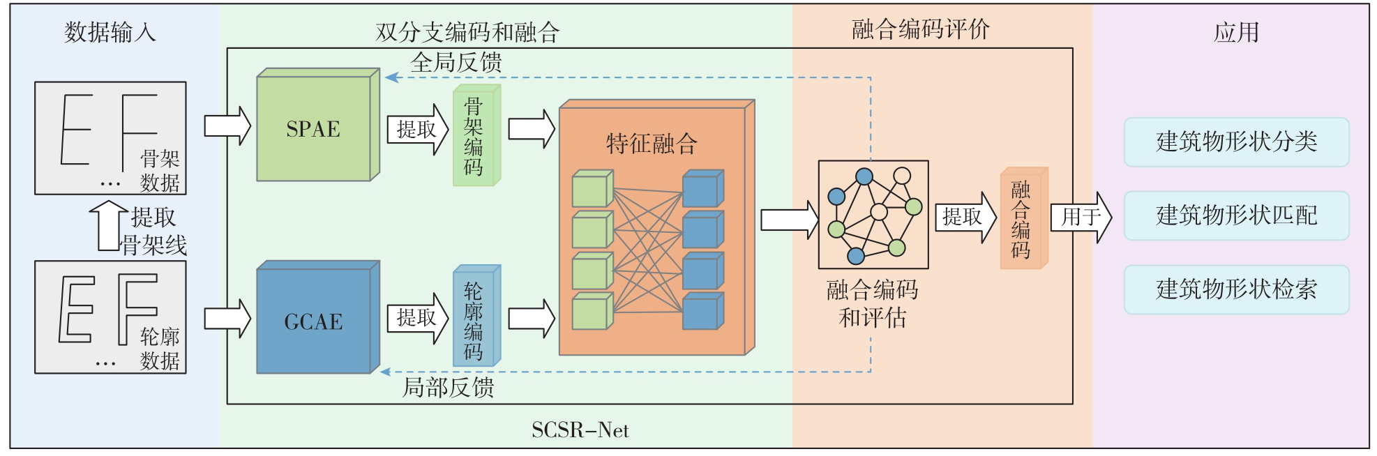
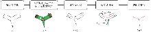
图2
骨架线构造流程"
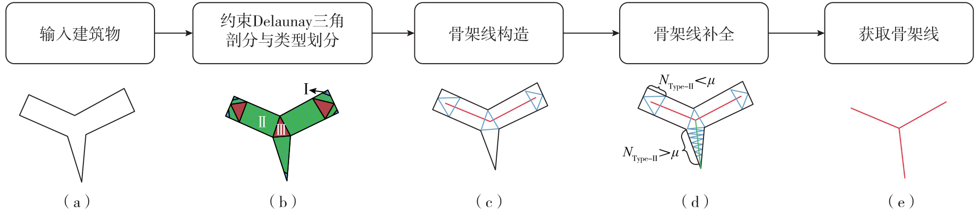
表1
骨架线特征"
| 特征 | 指标 | 计算公式 | 含义 | 图示 |
|---|---|---|---|---|
| 位置特征 | 横坐标 |  | 其中cx表示建筑物中心点的横坐标;r表示建筑物最大空间跨度 | 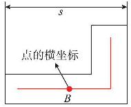 |
纵坐标 |  | 其中cy表示建筑物中心点的纵坐标 | 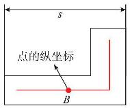 | |
| 结构特征 | 节点的度degi | - | 骨架线顶点的度 | 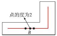 |
| 轮廓关联特征 | 最近距离特征 | 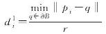 | 其中ƏB表示轮廓点集 | 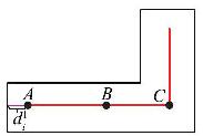 |
次近距离特征 | 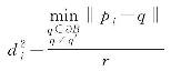 | 其中q′表示最近轮廓点 | 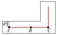 |
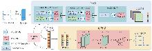
图3
SPAE模块结构"
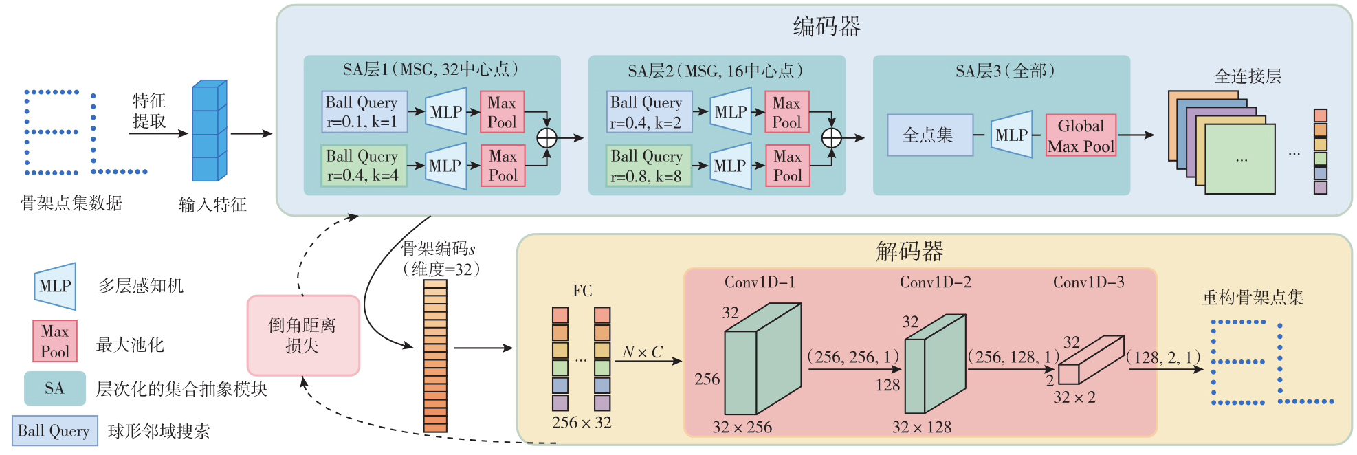
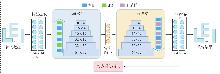
图4
GCAE模块结构"
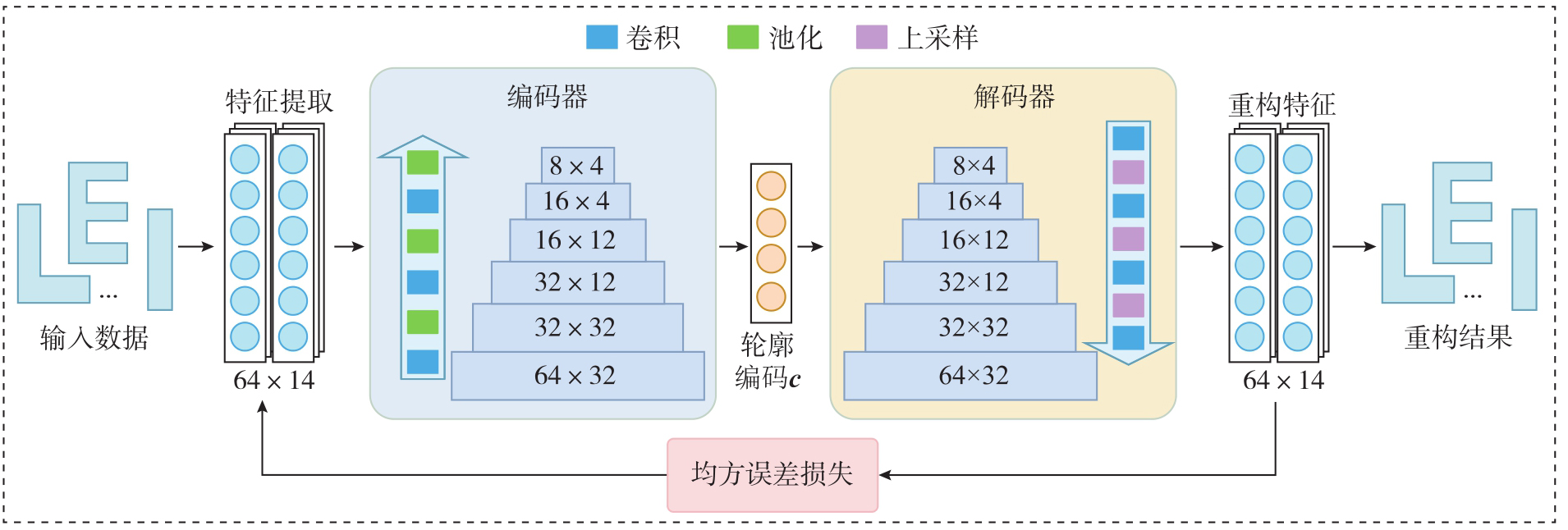
图5
SCSR-Net特征融合模块"
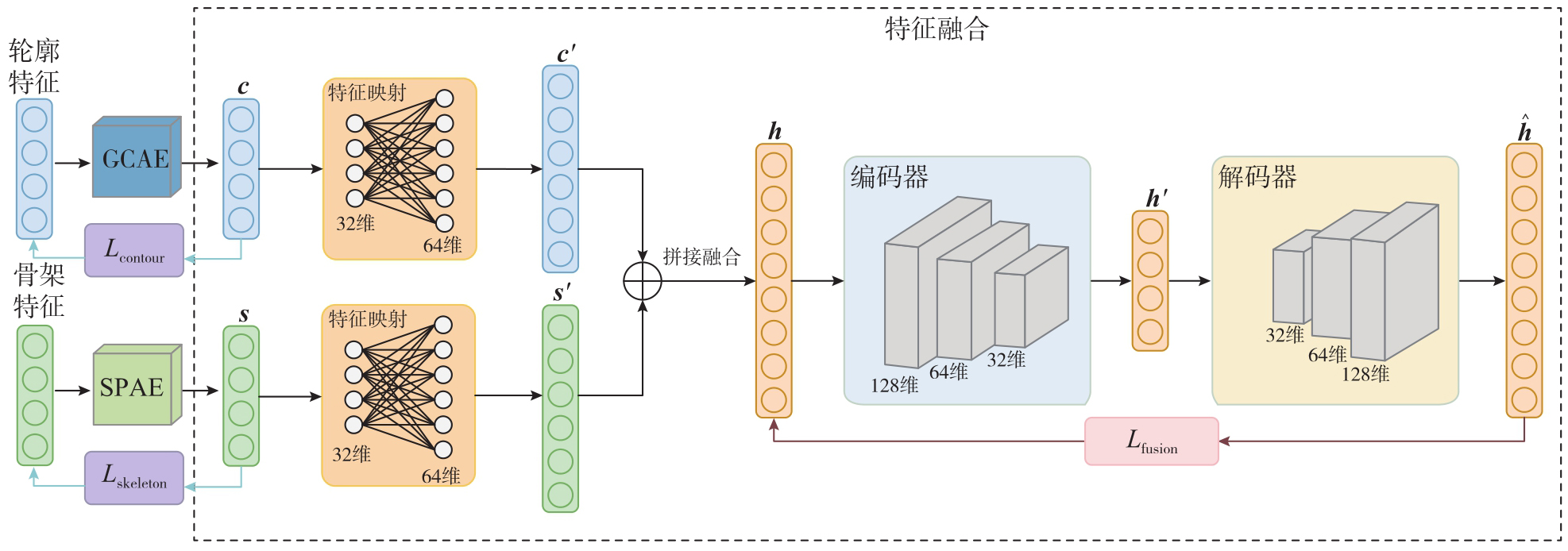
表2
10种类型建筑物骨架线样例"
| 类型 | E形 | F形 | H形 | I形 | L形 | O形 | T形 | U形 | Y形 | Z形 |
|---|---|---|---|---|---|---|---|---|---|---|
| 模板 |  |  |  |  |  |  |  |  |  |  |
| 数据 |  |  |  |  |  |  |  |  |  |  |
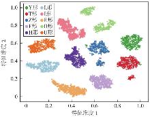
图6
10种类型建筑物可视化结果"
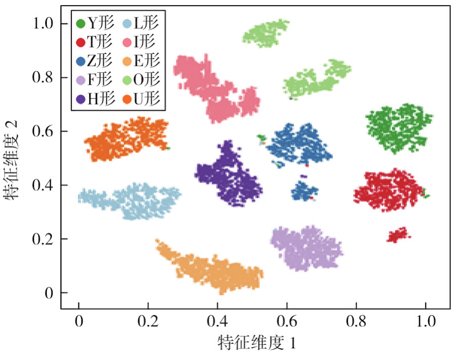
表3
不同方法形状匹配对比结果"
| 形状匹配方法 | FT | ST | DCG |
|---|---|---|---|
| 转向函数(TF) | 0.417 | 0.526 | 0.867 |
| 傅里叶描述符(FD) | 0.726 | 0.894 | 0.965 |
| 图编辑距离(GED) | 0.865 | 0.977 | 0.989 |
| 图卷积自编码器(GCAE) | 0.868 | 0.934 | 0.986 |
| LineStringNet模型 | 0.986 | 0.997 | 0.998 |
| 深度聚类形状自编码器(DCSAE) | 0.923 | 0.982 | 0.995 |
| SCSR-Net | 0.968 | 0.995 | 0.998 |
图7
纽约Tompkins Square Park周边建筑物数据集"
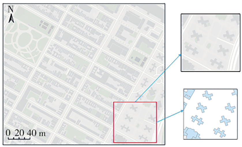
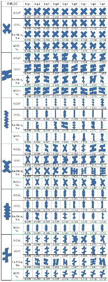
图8
建筑物检索试验结果"
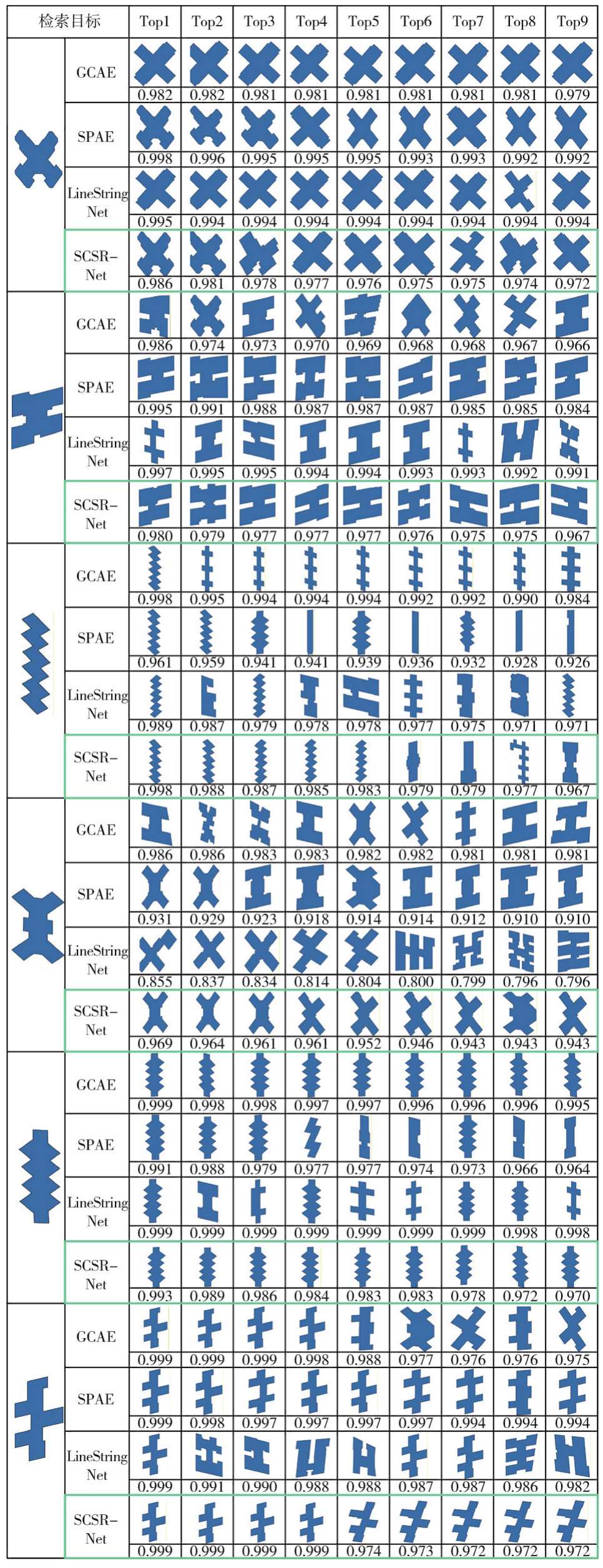
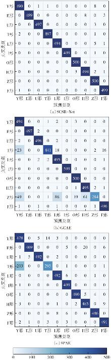
图9
混淆矩阵对比"

图10
部分匹配错误建筑物样例"
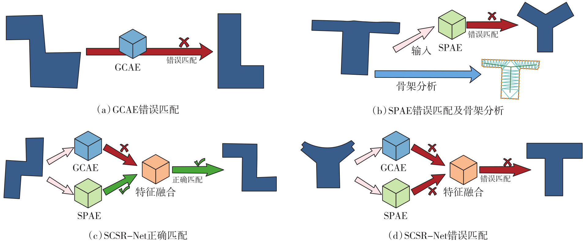
表4
不同融合方法对比试验结果"
| 融合方法 | FT | ST | DCG | 匹配准确率/(%) |
|---|---|---|---|---|
| 门控融合(未映射) | 0.835 | 0.966 | 0.985 | 91.12 |
| 注意力机制(未映射) | 0.816 | 0.920 | 0.980 | 91.98 |
| 加权拼接(未映射) | 0.891 | 0.982 | 0.989 | 94.34 |
| 门控融合(映射) | 0.871 | 0.969 | 0.986 | 93.22 |
| 注意力机制(映射) | 0.928 | 0.993 | 0.993 | 94.66 |
| SCSR-Net(映射) | 0.968 | 0.995 | 0.998 | 99.18 |
表5
动态权重与固定权重对比试验"
| 权重设计 | α1 | α2 | α3 | FT | ST | DCG | 匹配准确率/(%) |
|---|---|---|---|---|---|---|---|
| SCSR-Net | 动态调整 | 动态调整 | 动态调整 | 0.968 | 0.995 | 0.998 | 99.18 |
| 固定权重组1 | 0.8 | 0.10 | 0.10 | 0.759 | 0.961 | 0.953 | 74.72 |
| 固定权重组2 | 0.7 | 0.15 | 0.15 | 0.738 | 0.892 | 0.950 | 71.78 |
| 固定权重组3 | 0.6 | 0.20 | 0.20 | 0.661 | 0.838 | 0.939 | 70.10 |
| 固定权重组4 | 0.4 | 0.30 | 0.30 | 0.582 | 0.740 | 0.911 | 58.12 |
| 固定权重组5 | 0.3 | 0.35 | 0.35 | 0.536 | 0.734 | 0.899 | 54.60 |
图11
动态权重与固定权重混淆矩阵对比"
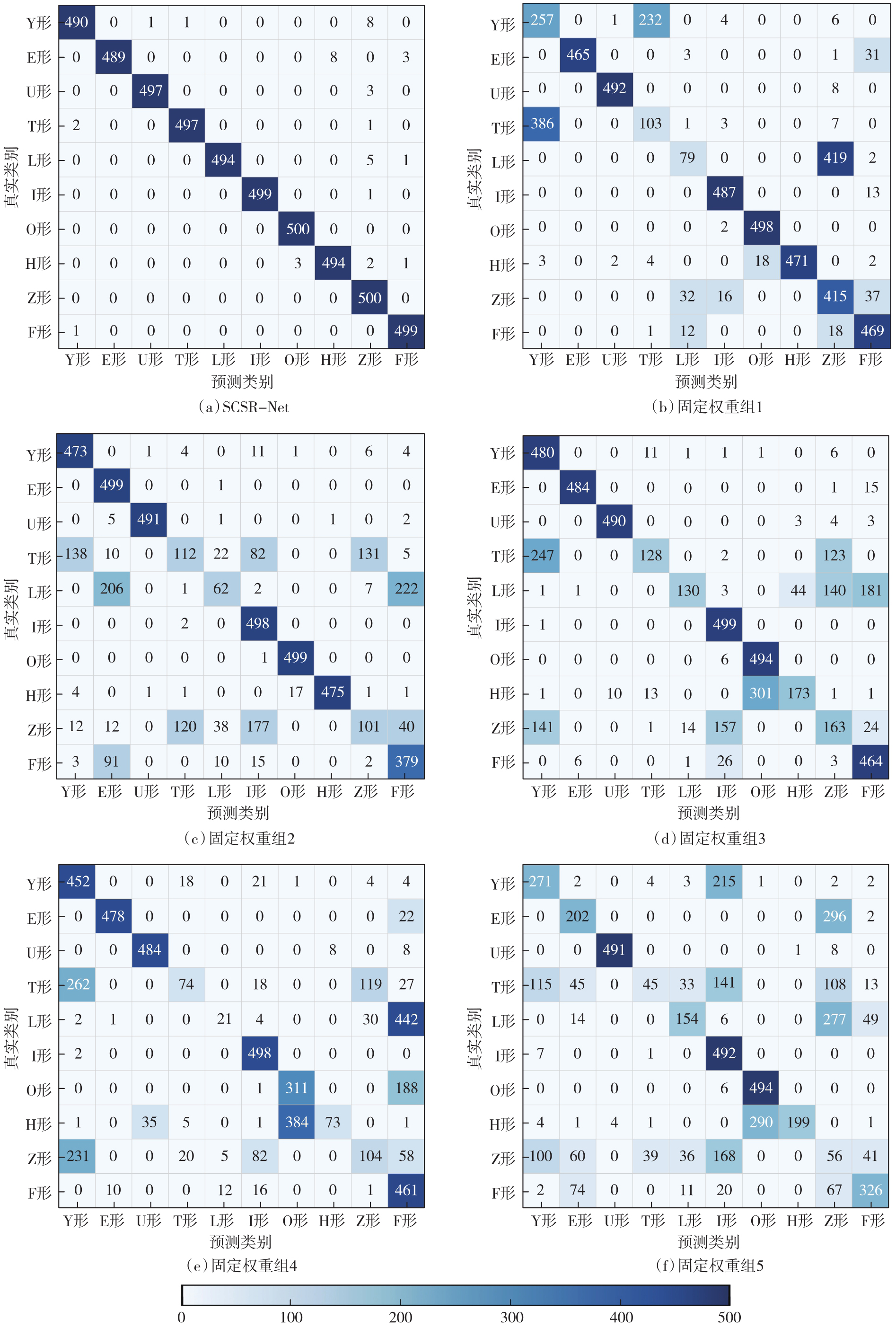
表6
不同轮廓点构造骨架线对模型的影响"
| 轮廓采样点数/骨架加密点数 | FT | ST | DCG | 匹配准确率/(%) |
|---|---|---|---|---|
| 32/16 | 0.771 | 0.911 | 0.97 | 80.06 |
| 32/32 | 0.748 | 0.944 | 0.972 | 76.24 |
| 32/64 | 0.753 | 0.900 | 0.967 | 78.96 |
| 64/16 | 0.951 | 0.976 | 0.995 | 96.36 |
| 64/32 | 0.968 | 0.995 | 0.998 | 99.18 |
| 64/64 | 0.953 | 0.995 | 0.997 | 97.42 |
| 128/16 | 0.912 | 0.985 | 0.994 | 97.08 |
| 128/32 | 0.951 | 0.993 | 0.997 | 98.80 |
| 128/64 | 0.943 | 0.997 | 0.997 | 97.78 |
表7
不同临近轮廓阶数试验结果"
| 阶数 | FT | ST | DCG | 匹配准确率/(%) |
|---|---|---|---|---|
| 一阶 | 0.847 | 0.960 | 0.986 | 95.12 |
| 二阶 | 0.968 | 0.995 | 0.998 | 99.18 |
| 三阶 | 0.855 | 0.954 | 0.987 | 91.56 |
| 四阶 | 0.827 | 0.938 | 0.982 | 89.24 |
表8
不同权重下试验结果"
| λ1 | λ2 | 匹配准确率/(%) | |||||||||
|---|---|---|---|---|---|---|---|---|---|---|---|
| Y形 | E形 | F形 | U形 | T形 | L形 | I形 | O形 | H形 | Z形 | ||
| 0.1 | 0.9 | 95.6 | 92.0 | 98.2 | 98.6 | 63.8 | 98.8 | 99.4 | 99.6 | 96.8 | 98.6 |
| 0.2 | 0.8 | 95.8 | 94.0 | 99.2 | 99.6 | 65.0 | 99.0 | 99.6 | 99.6 | 97.0 | 99.4 |
| 0.3 | 0.7 | 96.2 | 96.2 | 99.6 | 99.6 | 68.2 | 99.4 | 99.8 | 99.6 | 97.8 | 100.0 |
| 0.4 | 0.6 | 97.8 | 96.4 | 99.6 | 99.6 | 92.4 | 99.0 | 99.8 | 99.6 | 98.6 | 100.0 |
| 0.5 | 0.5 | 98.0 | 97.8 | 99.8 | 99.4 | 99.4 | 98.8 | 99.8 | 100.0 | 98.8 | 100.0 |
| 0.6 | 0.4 | 98.0 | 99.4 | 99.8 | 99.0 | 99.2 | 98.8 | 100.0 | 100.0 | 99.2 | 96.0 |
| 0.7 | 0.3 | 97.8 | 99.8 | 99.4 | 96.6 | 98.2 | 98.8 | 100.0 | 100.0 | 98.8 | 79.6 |
| 0.8 | 0.2 | 98.0 | 99.8 | 99.0 | 91.8 | 97.8 | 99.0 | 100.0 | 100.0 | 99.2 | 77.2 |
| 0.9 | 0.1 | 97.6 | 99.6 | 98.8 | 94.6 | 93.8 | 99.0 | 100.0 | 100.0 | 99.2 | 72.0 |
表9
不同δ/K参数下SCSR-Net试验结果"
| δ/K | FT | ST | DCG |
|---|---|---|---|
| 0.001/5 | 0.873 | 0.957 | 0.986 |
| 0.001/10 | 0.892 | 0.962 | 0.989 |
| 0.001/20 | 0.861 | 0.951 | 0.984 |
| 0.0005/5 | 0.953 | 0.993 | 0.997 |
| 0.0005/10 | 0.968 | 0.995 | 0.998 |
| 0.0005/20 | 0.948 | 0.982 | 0.995 |
| 0.0001/5 | 0.927 | 0.980 | 0.994 |
| 0.0001/10 | 0.934 | 0.984 | 0.995 |
| 0.0001/20 | 0.916 | 0.979 | 0.993 |
表10
不同建筑物尺度缩放编码相似度对比结果"
| 缩放系数 | Y形 | L形 | E形 | U形 | I形 | F形 | O形 | T形 | H形 | Z形 |
|---|---|---|---|---|---|---|---|---|---|---|
| 1∶0.5 | 0.996 1 | 0.995 7 | 0.998 9 | 0.997 7 | 0.999 0 | 0.997 5 | 0.999 7 | 0.997 5 | 0.999 4 | 0.997 7 |
| 1∶2 | 0.990 6 | 0.999 0 | 0.998 6 | 0.998 1 | 0.999 5 | 0.996 9 | 0.999 6 | 0.999 0 | 0.999 2 | 0.998 2 |
| 1∶5 | 0.997 6 | 0.999 4 | 0.996 1 | 0.996 2 | 0.998 9 | 0.995 7 | 0.999 8 | 0.998 7 | 0.998 4 | 0.997 3 |
| 1∶10 | 0.998 7 | 0.999 7 | 0.995 1 | 0.996 3 | 0.999 1 | 0.998 3 | 0.999 7 | 0.997 6 | 0.998 8 | 0.997 2 |
| 1∶20 | 0.997 6 | 0.995 8 | 0.997 2 | 0.997 3 | 0.998 8 | 0.998 1 | 0.999 8 | 0.997 9 | 0.998 3 | 0.997 8 |
| [1] | Batty M. The size, scale, and shape of cities[J]. Science, 2008, 319(5864): 769-771. |
| [2] | Arefi M. Urban transformation: understanding city design and form[J]. Journal of Urban Design, 2011, 16(2): 304-306. |
| [3] | Deng Min, Li Zhilin, Chen Xiaoyong. Extended Hausdorff distance for spatial objects in GIS[J]. International Journal of Geographical Information Science, 2007, 21(4): 459-475. |
| [4] | Ai Tinghua, Cheng Xiaoqiang, Liu Pengcheng, et al. A shape analysis and template matching of building features by the Fourier transform method[J]. Computers, Environment and Urban Systems, 2013, 41: 219-233. |
| [5] | Ballatore A, Bertolotto M, Wilson D C. An evaluative baseline for geo-semantic relatedness and similarity[J]. GeoInformatica, 2014, 18(4): 747-767. |
| [6] | Moradi M, Roche S, Mostafavi M A. A novel GIS-based polygon shape similarity measure applied to OSM building footprints[J]. Advances in Cartography and GIScience of the ICA, 2025, 5: 1-9. |
| [7] | Larson R R. Geographic information retrieval and spatial browsing[C]//Proceedings of the 32nd Clinic on Library Applications of Data Processing. Urbana-Champaign: Graduate School of Library and Information Science, University of Illinois at Urbana-Champaign, 1996: 81-124. |
| [8] | Veltkamp R C, Hagedoorn M. State of the art in shape matching[M]//Lew M S. Principles of Visual Information Retrieval. London: Springer, 2001: 87-119. |
| [9] | Zhang X, Ai T H, Stoter J, et al. Data matching of building polygons at multiple map scales improved by contextual information and relaxation[J]. ISPRS Journal of Photogrammetry and Remote Sensing, 2014, 92: 147-163. |
| [10] | Yan Yuhan, Wu Pengda, Yin Yong, et al. Robust multi-source geographic entities matching by maximizing geometric and semantic similarity[J]. Scientific Reports, 2024, 14(1): 31616. |
| [11] | Yan Haowen. Quantitative relations between spatial similarity degree and map scale change of individual linear objects in multi-scale map spaces[J]. Geocarto International, 2015, 30(4): 472-482. |
| [12] | Yan Xiongfeng, Ai Tinghua, Zhang Xiang. Template matching and simplification method for building features based on shape cognition[J]. ISPRS International Journal of Geo-Information, 2017, 6(8): 250. |
| [13] | Sester M. Cartographic generalization[J]. Journal of Spatial Information Science, 2020(21): 5-11. |
| [14] |
武芳, 巩现勇, 杜佳威. 地图制图综合回顾与前望[J]. 测绘学报, 2017, 46(10): 1645-1664. DOI: .
doi: 10.11947/j.AGCS.2017.20170287 |
|
Wu Fang, Gong Xianyong, Du Jiawei. Overview of the research progress in automated map generalization[J]. Acta Geodaetica et Cartographica Sinica, 2017, 46(10): 1645-1664. DOI: .
doi: 10.11947/j.AGCS.2017.20170287 |
|
| [15] | 钱海忠, 武芳, 朱鲲鹏, 等. 一种基于降维技术的街区综合方法[J]. 测绘学报, 2007, 36(1): 102-107, 118. |
| Qian Haizhong, Wu Fang, Zhu Kunpeng, et al. A generalization method of street block based on dimension-reducing technique[J]. Acta Geodaetica et Cartographica Sinica, 2007, 36(1): 102-107, 118. | |
| [16] | Zahn C T, Roskies R Z. Fourier descriptors for plane closed curves[J]. IEEE Transactions on Computers, 1972, C-21(3): 269-281. |
| [17] | Arkin E M, Chew L P, Huttenlocher D P, et al. An efficiently computable metric for comparing polygonal shapes[J]. IEEE Transactions on Pattern Analysis and Machine Intelligence, 1991, 13(3): 209-216. |
| [18] | Persoon E, Fu K S. Shape discrimination using Fourier descriptors[J]. IEEE Transactions on Systems, Man, and Cybernetics, 1977, 7(3): 170-179. |
| [19] | Zhang Dengsheng, Lu Guojun. Review of shape representation and description techniques[J]. Pattern Recognition, 2004, 37(1): 1-19. |
| [20] | Belongie S, Malik J, Puzicha J. Shape matching and object recognition using shape contexts[J]. IEEE Transactions on Pattern Analysis and Machine Intelligence, 2002, 24(4): 509-522. |
| [21] | Latecki L J, Lakamper R. Shape similarity measure based on correspondence of visual parts[J]. IEEE Transactions on Pattern Analysis and Machine Intelligence, 2000, 22(10): 1185-1190. |
| [22] |
晏雄锋, 艾廷华, 杨敏, 等. 地图空间形状认知的自编码器深度学习方法[J]. 测绘学报, 2021, 50(6): 757-765. DOI: .
doi: 10.11947/j.AGCS.2021.20210046 |
|
Yan Xiongfeng, Ai Tinghua, Yang Min, et al. Shape cognition in map space using deep auto-encoder learning[J]. Acta Geodaetica et Cartographica Sinica, 2021, 50(6): 757-765. DOI: .
doi: 10.11947/j.AGCS.2021.20210046 |
|
| [23] | Yan Xiongfeng, Ai Tinghua, Yang Min, et al. Graph convolutional autoencoder model for the shape coding and cognition of buildings in maps[J]. International Journal of Geographical Information Science, 2021, 35(3): 490-512. |
| [24] | Yan Xiongfeng, Yang Min. A comparative study of various deep learning approaches to shape encoding of planar geospatial objects[J]. ISPRS International Journal of Geo-Information, 2022, 11(10): 527. |
| [25] | Zhou Z Y, Fu C, Weibel R. Move and remove: multi-task learning for building simplification in vector maps with a graph convolutional neural network[J]. ISPRS Journal of Photogrammetry and Remote Sensing, 2023, 202: 205-218. |
| [26] | Yan Xiongfeng, Ai Tinghua, Yang Min, et al. A graph convolutional neural network for classification of building patterns using spatial vector data[J]. ISPRS Journal of Photogrammetry and Remote Sensing, 2019, 150: 259-273. |
| [27] |
于洋洋, 贺康杰, 武芳, 等. 面状居民地形状分类的图卷积神经网络方法[J]. 测绘学报, 2022, 51(11): 2390-2402. DOI: .
doi: 10.11947/j.AGCS.2022.20210134 |
|
Yu Yangyang, He Kangjie, Wu Fang, et al. Graph convolution neural network method for shape classification of areal settlements[J]. Acta Geodaetica et Cartographica Sinica, 2022, 51(11): 2390-2402. DOI: .
doi: 10.11947/j.AGCS.2022.20210134 |
|
| [28] |
张付兵, 孙群, 马京振, 等. 融合全局和局部特征的建筑物形状智能分类方法[J]. 测绘学报, 2024, 53(9): 1842-1852. DOI: .
doi: 10.11947/j.AGCS.2024.20240040 |
|
Zhang Fubing, Sun Qun, Ma Jingzhen, et al. An intelligent classification method for building shape based on fusion of global and local features[J]. Acta Geodaetica et Cartographica Sinica, 2024, 53(9): 1842-1852. DOI: .
doi: 10.11947/j.AGCS.2024.20240040 |
|
| [29] |
周旭升, 谭永滨, 于忠海, 等. 融合矢量结构特征的复杂建筑物形状识别方法[J]. 测绘学报, 2026, 55(5): 838-849. DOI: .
doi: 10.11947/j.AGCS.2026.20250445 |
|
Zhou Xusheng, Tan Yongbin, Yu Zhonghai, et al. A complex building shape recognition method integrating vector structural features[J]. Acta Geodaetica et Cartographica Sinica, 2026, 55(5): 838-849. DOI: .
doi: 10.11947/j.AGCS.2026.20250445 |
|
| [30] |
刘鹏程, 黄欣, 马宏然, 等. 建筑物多边形高精度识别的傅里叶形状描述子神经网络方法[J]. 测绘学报, 2022, 51(9): 1969-1976. DOI: .
doi: 10.11947/j.AGCS.2022.20210730 |
|
Liu Pengcheng, Huang Xin, Ma Hongran, et al. Fourier descriptor-based neural network method for high-precision shape recognition of building polygon[J]. Acta Geodaetica et Cartographica Sinica, 2022, 51(9): 1969-1976. DOI: .
doi: 10.11947/j.AGCS.2022.20210730 |
|
| [31] | 杨雨雪, 王红艳, 张玲玲, 等. 基于细化和最小生成树的多边形主骨架线提取[J]. 上海师范大学学报(自然科学版), 2022, 51(2): 204-209. |
| Yang Yuxue, Wang Hongyan, Zhang Lingling, et al. The extraction of main skeleton line of polygon based on thinning and minimum spanning tree[J]. Journal of Shanghai Normal University (Natural Sciences), 2022, 51(2): 204-209. | |
| [32] | 罗登瀚, 钱海忠, 何海威, 等. 面状建筑物多层次骨架线提取方法[J]. 测绘科学技术学报, 2019, 36(3): 324-330. |
| Luo Denghan, Qian Haizhong, He Haiwei, et al. A method of extracting multi-scale skeleton lines for polygon buildings[J]. Journal of Geomatics Science and Technology, 2019, 36(3): 324-330. | |
| [33] | Li Yiyan, Lu Xiaomin, Yan Haowen, et al. A skeleton-line-based graph convolutional neural network for areal settlements' shape classification[J]. Applied Sciences, 2022, 12(19): 10001. |
| [34] | 禄小敏, 马犇, 闫浩文, 等. 基于骨架线的地图建筑物形状分类方法[J]. 浙江大学学报(工学版), 2024, 58(12): 2479-2488. |
| Lu Xiaomin, Ma Ben, Yan Haowen, et al. Shape classifying method of map building based on skeleton line[J]. Journal of Zhejiang University (Engineering Science), 2024, 58(12): 2479-2488. | |
| [35] | Qi C R, Su H, Mo K, et al. PointNet: deep learning on point sets for 3D classification and segmentation[C]//Proceedings of 2017 IEEE Conference on Computer Vision and Pattern Recognition. Honolulu: IEEE, 2017: 77-85. |
| [36] | Qi C R, Yi L, Su H, et al. Pointnet++: deep hierarchical feature learning on point sets in a metric space[C]//Proceedings of the 31st International Conference on Neural Information Processing Systems. Red Hook: Curran Associates Inc., 2017: 5105-5114. |
| [37] | Lu Xiechun, Li Houpu, Xu Yongyang, et al. Measuring the similarity between shapes of buildings using graph edit distance[J]. International Journal of Digital Earth, 2024, 17(1): 2310749. |
| [38] | Li Pengbo, Yan Haowen, Lu Xiaomin. A Siamese neural network for learning the similarity metrics of linear features[J]. International Journal of Geographical Information Science, 2023, 37(3): 684-711. |
| [39] | 陈占龙, 刘江文, 徐永洋, 等. 融合深度聚类网络与模板匹配的建筑物化简方法[J]. 测绘科学技术学报, 2025, 41(5): 448-457. |
| Chen Zhanlong, Liu Jiangwen, Xu Yongyang, et al. A building simplification method based on deep clustering network and template matching[J]. Journal of Geomatics Science and Technology, 2025, 41(5): 448-457. |
| [1] | 孙咏琪, 戴晨光, 张振超, 秦进春, 宿钰. 融合相对深度的高分辨率光学卫星遥感影像跨域语义分割框架[J]. 测绘学报, 2026, 55(8): 1425-1438. |
| [2] | 黄文君, 孙群, 徐青, 范龙, 余岸竹, 张付兵. 融合频域特征与地形先验的全球沿海DEM超分辨率重建方法[J]. 测绘学报, 2025, 54(8): 1518-1531. |
| [3] | 万杰, 谢忠, 徐永洋, 陶留锋. 面向城市道路场景的车载LiDAR点云语义分割U形图卷积网络方法[J]. 测绘学报, 2025, 54(7): 1280-1293. |
| [4] | 赵一鸣, 胡克林, 涂可龙, 卿雅娴, 杨超, 祁昆仑, 吴华意. 基于SAR与光学遥感影像融合的多标签场景分类方法[J]. 测绘学报, 2025, 54(5): 911-923. |
| [5] | 曹云刚, 杨鹏, 龚江波, 朱高, 沈星宇. 空间关系增强与异构特征融合相结合的道路信息提取方法[J]. 测绘学报, 2025, 54(12): 2219-2232. |
| [6] | 龚良雄, 李星华, 程远明, 赵兴友, 谢仁平, 王红根. 时空差异增强与自适应特征融合的轻量级遥感影像变化检测网络[J]. 测绘学报, 2025, 54(1): 136-153. |
| [7] | 唐建波, 胡致远, 彭举, 夏何炎, 丁俊杰, 张玉玉, 梅小明. 融合视觉特征与运动特征的众源轨迹数据道路交叉口识别方法[J]. 测绘学报, 2025, 54(1): 182-193. |
| [8] | 张付兵, 孙群, 马京振, 孙士杰, 温伯威. 融合全局和局部特征的建筑物形状智能分类方法[J]. 测绘学报, 2024, 53(9): 1842-1852. |
| [9] | 徐涛, 杨元维, 高贤君, 王志威, 潘越, 李少华, 许磊, 王艳军, 刘波, 余静, 吴凤敏, 孙浩宇. 融合图卷积与多尺度特征的接触网点云语义分割[J]. 测绘学报, 2024, 53(8): 1624-1633. |
| [10] | 鄢薪, 慎利, 潘俊杰, 戴延帅, 王继成, 郑晓莉, 李志林. 多尺度特征融合与空间优化的弱监督高分遥感建筑变化检测[J]. 测绘学报, 2024, 53(8): 1586-1597. |
| [11] | 张彩丽, 向隆刚, 李雅丽, 高松峰, 潘传姣. 路段级导航属性信息挖掘[J]. 测绘学报, 2024, 53(2): 367-378. |
| [12] | 林云浩, 王艳军, 李少春, 蔡恒藩. 一种耦合DeepLab与Transformer的农作物种植类型遥感精细分类方法[J]. 测绘学报, 2024, 53(2): 353-366. |
| [13] | 庞世燕, 郝京京, 左志奇, 兰晶晶, 胡翔云. 融合密集连接和自注意力机制的高分辨率遥感影像变化检测方法[J]. 测绘学报, 2024, 53(12): 2244-2253. |
| [14] | 罗飘, 许俊奎, 武芳, 吕亚坤, 庄清文. 一种生成式神经网络的道路简化方法[J]. 测绘学报, 2024, 53(10): 2007-2020. |
| [15] | 杭仁龙, 李成相, 刘青山. 谱间对比学习的高光谱图像无监督特征提取[J]. 测绘学报, 2023, 52(7): 1164-1174. |
| 阅读次数 | ||||||
|
全文 |
|
|||||
|
摘要 |
|
|||||
