

Acta Geodaetica et Cartographica Sinica ›› 2025, Vol. 54 ›› Issue (1): 14-25.doi: 10.11947/j.AGCS.2025.20230548
• Geodesy and Navigation • Previous Articles Next Articles
Fei YANG1( ), Yingying WANG1, Zhicai LI1(), Boyao YU2, Junli WU3, Yunchang CAO4, Shu ZHANG2
Received:2023-11-25
Revised:2024-12-25
Online:2025-02-17
Published:2025-02-17
Contact:
Zhicai LI
E-mail:yangfei@cumtb.edu.cn;zcli@cumtb.edu.cn
About author:YANG Fei (1991—), male, PhD, associate professor, majors in GNSS high-precision data processing and GNSS meteorology. E-mail: yangfei@cumtb.edu.cn
Supported by:CLC Number:
Fei YANG, Yingying WANG, Zhicai LI, Boyao YU, Junli WU, Yunchang CAO, Shu ZHANG. Analysis of heavy rainstorm in Beijing in 2023 based on GNSS observations[J]. Acta Geodaetica et Cartographica Sinica, 2025, 54(1): 14-25.
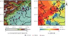
Fig. 1
Distribution of GNSS stations, radiosonde stations and meteorological stations in Beijing and its surrounding areas and total precipitation"
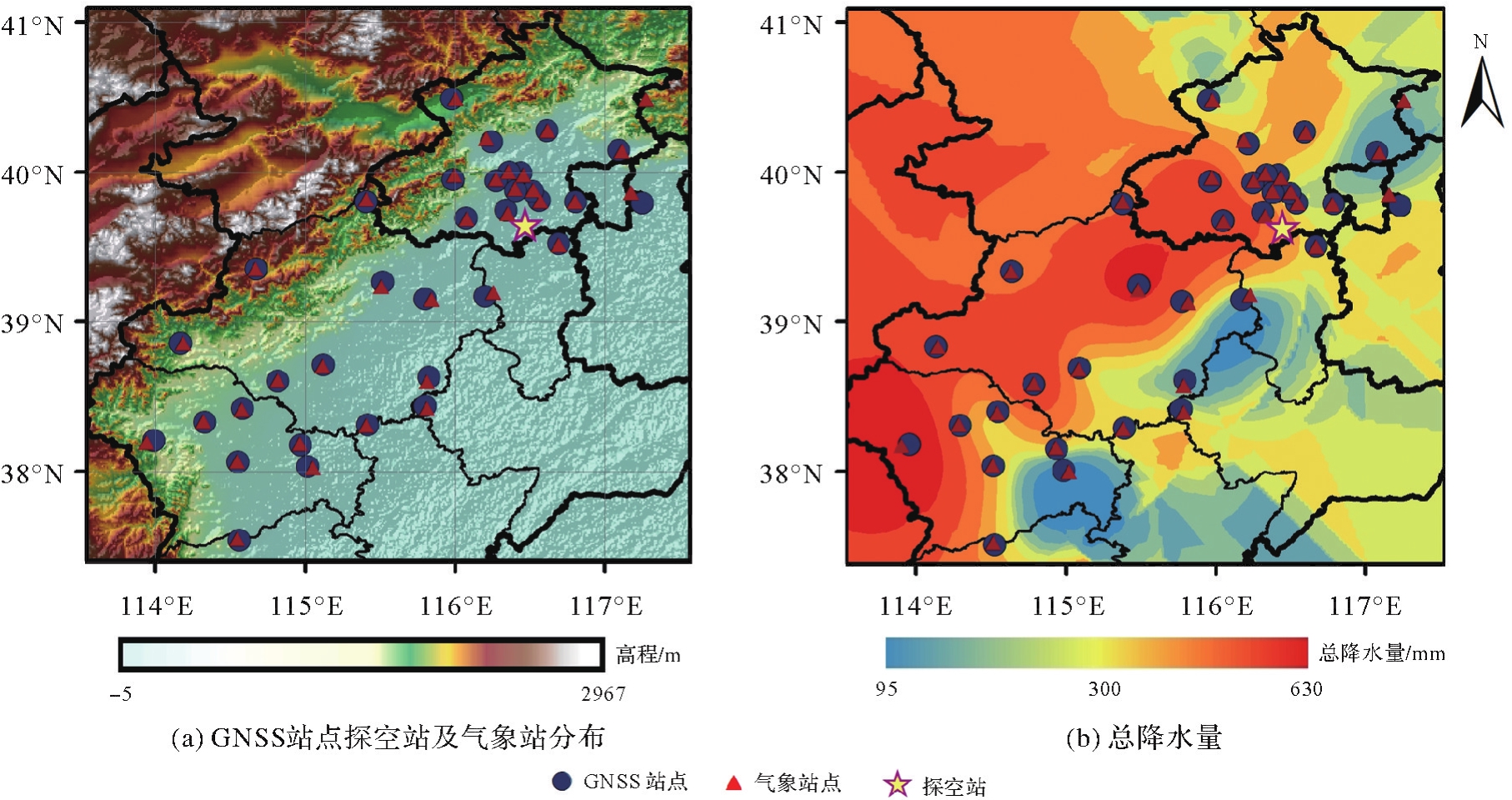
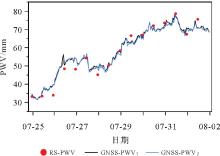
Fig. 2
Sequence of RS-PWV and GNSS-PWV"
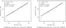
Fig. 3
Correlation between RS-PWV and GNSS-PWV"
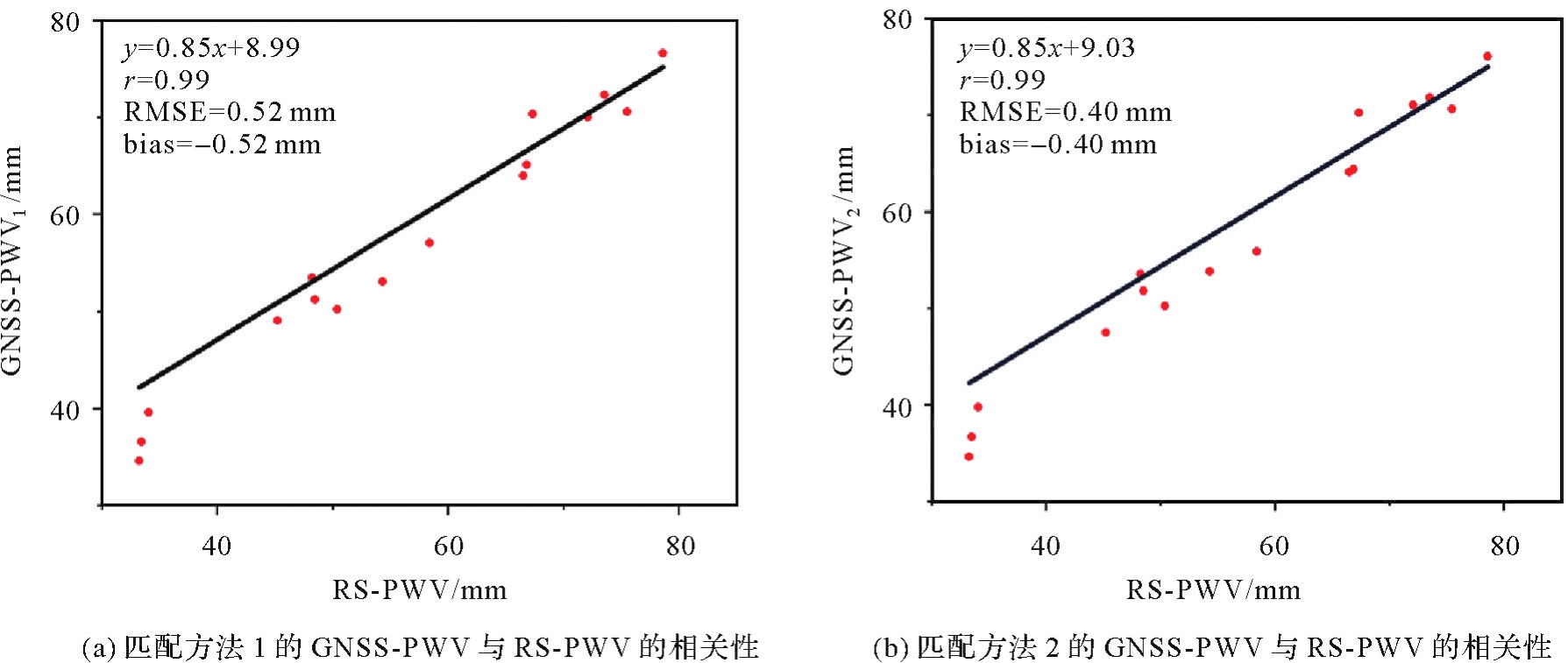
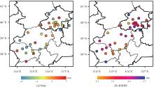
Fig. 4
Distribution of bias and RMSE in GNSS-PWV and ERA5-PWV"
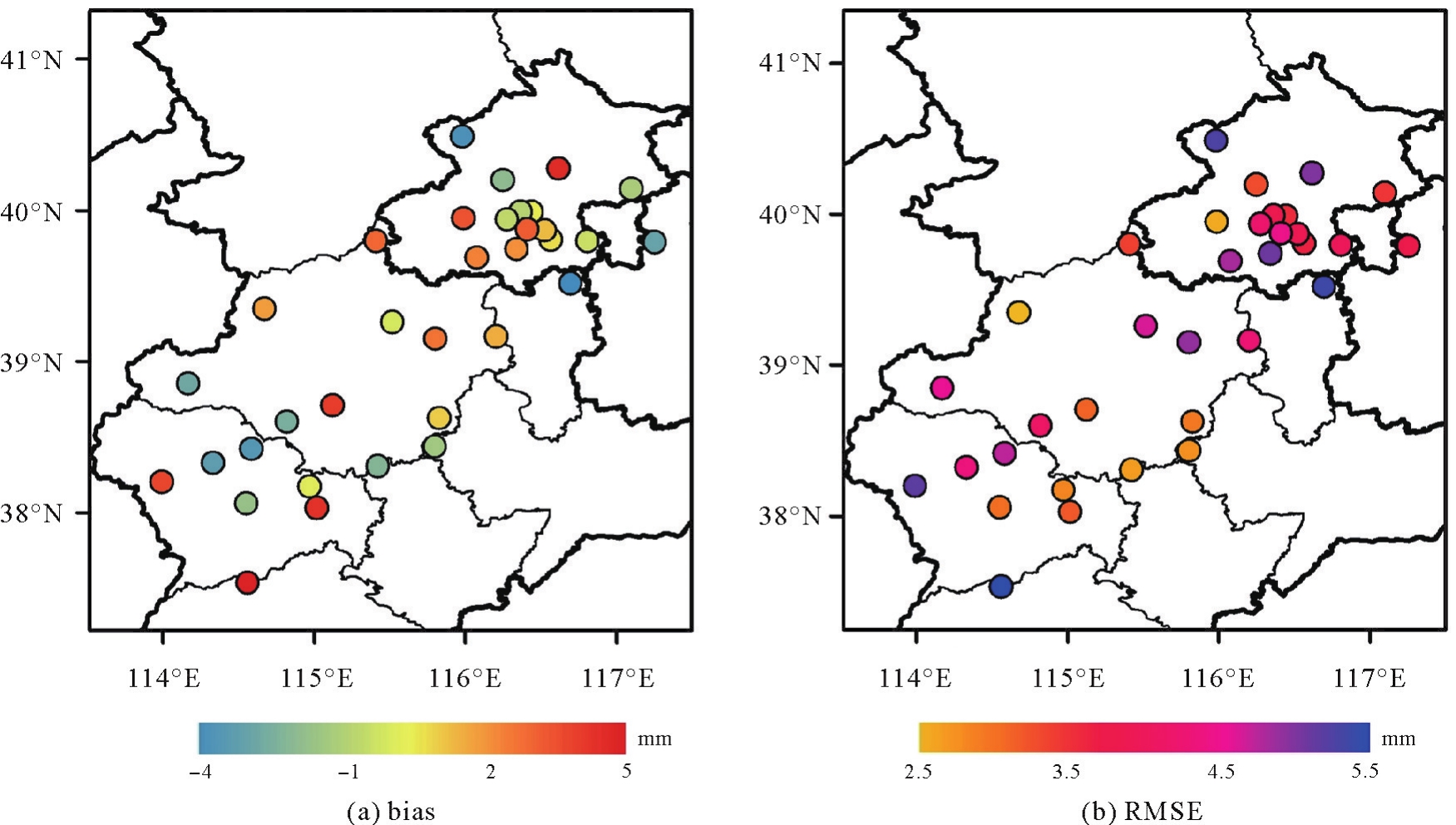
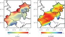
Fig. 5
GNSS-PWV spatial grid data and ERA5-PWV bias and RMSE"

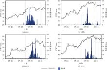
Fig. 6
Temporal relationship between GNSS-PWV and rainfall"

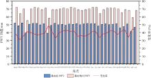
Fig. 7
Variation and rate of GNSS-PWV mean value before and during rainstorm"
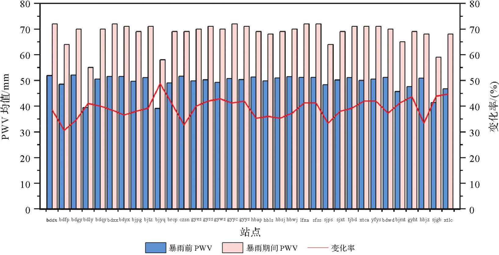
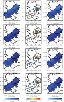
Fig. 8
GNSS-PWV spatial variation of rainfall"

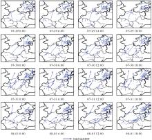
Fig. 9
Variation of the tropospheric delay gradient"

| [1] | DUAN Jingping, BEVIS M, FANG Peng, et al. GPS meteorology: direct estimation of the absolute value of precipitable water[J]. Journal of Applied Meteorology, 1996, 35(6): 830-838. |
| [2] | ZHAO Yanyan, ZHAO Hongwei, LI Junqiang, et al. Comprehensive validation and calibration of MODIS PWV over mainland China[J]. Atmosphere, 2022, 13(11): 1763. |
| [3] | LI Longjiang, ZHANG Kefei, WU Suqin, et al. An improved method for rainfall forecast based on GNSS-PWV[J]. Remote Sensing, 2022, 14(17): 4280. |
| [4] | BARBAROSA A, WIJAYA D D, TANUWIJAYA Z A J, et al. Correlation analysis of GNSS-derived precipitable water vapor (PWV) with rainfall data in Indonesia[J]. IOP Conference Series: Earth and Environmental Science, 2023, 1245(1): 012035. |
| [5] |
施闯, 张卫星, 曹云昌, 等. 基于北斗/GNSS的中国-中南半岛地区大气水汽气候特征及同降水的相关分析[J]. 测绘学报, 2020, 49(9): 1112-1119. DOI:.
doi: 10.11947/j.AGCS.2020.20200339 |
|
SHI Chuang, ZHANG Weixing, CAO Yunchang, et al. Atmospheric water vapor climatological characteristics over Indo-China region based on BeiDou/GNSS and relationships with precipitation[J]. Acta Geodaetica et Cartographica Sinica, 2020, 49(9): 1112-1119. DOI:.
doi: 10.11947/j.AGCS.2020.20200339 |
|
| [6] | KE Fuyang, ZHAO Pan, YU Wei, et al. Response of Meiyu process considering the temporal and spatial characteristics of GNSS PWV[J]. Theoretical and Applied Climatology, 2024, 155(2): 1301-1319. |
| [7] | 郑志卿, 张克非, 师嘉奇, 等. GNSS-PWV结合多气象要素分析“21·7”河南特大暴雨过程[J]. 大地测量与地球动力学, 2023, 43(8): 809-815. |
| ZHENG Zhiqing, ZHANG Kefei, SHI Jiaqi, et al. GNSS-PWV combined with multi-meteorological elements analysis of “21·7” Henan heavy rain process[J]. Journal of Geodesy and Geodynamics, 2023, 43(8): 809-815. | |
| [8] | ZHAO Qingzhi, YAO Yibin, YAO Wanqiang. GPS-based PWV for precipitation forecasting and its application to a typhoon event[J]. Journal of Atmospheric and Solar-Terrestrial Physics, 2018, 167: 124-133. |
| [9] | LE T T, PHAM B T, LY H B, et al. Development of 48-hour precipitation forecasting model using nonlinear autoregressive neural network[M]. Singapore: Springer Singapore, 2019: 1191-1196. |
| [10] | LIU Yang, ZHAO Qingzhi, YAO Wanqiang, et al. Short-term rainfall forecast model based on the improved BP-NN algorithm[J]. Scientific Reports, 2019, 9: 19751. |
| [11] | BENEVIDES P, CATALAO J, NICO G. Neural network approach to forecast hourly intense rainfall using GNSS precipitable water vapor and meteorological sensors[J]. Remote Sensing, 2019, 11(8): 966. |
| [12] | YAO Yibin, SHAN Lulu, ZHAO Qingzhi. Establishing a method of short-term rainfall forecasting based on GNSS-derived PWV and its application[J]. Scientific Reports, 2017, 7: 12465. |
| [13] | MA Zengqi, GUO Guohe, CAI Min, et al. A combined linear-nonlinear short-term rainfall forecast method using GNSS-derived PWV[J]. Atmosphere, 2022, 13(9): 1381. |
| [14] | GONG Yangzhao, LIU Zhizhao. Evaluating the accuracy of Jason-3 water vapor product using PWV data from global radiosonde and GNSS stations[J]. IEEE Transactions on Geoscience and Remote Sensing, 2021, 59(5): 4008-4017. |
| [15] | ZHU Dantong, ZHANG Kefei, YANG Liu, et al. Evaluation and calibration of MODIS near-infrared precipitable water vapor over China using GNSS observations and ERA-5 reanalysis dataset[J]. Remote Sensing, 2021, 13(14): 2761. |
| [16] | LU Cuixian, ZHANG Yushan, ZHENG Yuxin, et al. Precipitable water vapor fusion of MODIS and ERA5 based on convolutional neural network[J]. GPS Solutions, 2022, 27(1): 15. |
| [17] | HUANG Liangke, MO Zhixiang, LIU Lilong, et al. Evaluation of hourly PWV products derived from ERA5 and MERRA-2 over the Tibetan Plateau using ground-based GNSS observations by two enhanced models[J]. Earth and Space Science, 2021, 8(5): e2020EA001516. |
| [18] | 于维. 融合GNSS可降水量的江苏省梅雨演变规律及预测研究[D]. 南京: 南京信息工程大学, 2022. |
| YU Wei. Study on evolution and prediction of Meiyu in Jiangsu Province with GNSS precipitable water vapor[D]. Nanjing: Nanjing University of Information Science and Technology, 2022. | |
| [19] | YANG Fei, SUN Yilin, MENG Xiaolin, et al. Assessment of tomographic window and sampling rate effects on GNSS water vapor tomography[J]. Satellite Navigation, 2023, 4(1): 7. |
| [20] | YANG Fei, GONG Xu, WANG Yingying, et al. GNSS water vapor tomography based on Kalman filter with optimized noise covariance[J]. GPS Solutions, 2023, 27(4): 181. |
| [21] |
杨飞, 郭际明, 陈明, 等. GNSS大气加权平均温度经验模型精化方法的建立和分析[J]. 测绘学报, 2022, 51(11): 2339-2345. DOI:.
doi: 10.11947/j.AGCS.2022.20210269 |
|
YANG Fei, GUO Jiming, CHEN Ming, et al. Establishment and analysis of a refinement method for the GNSS empirical weighted mean temperature model[J]. Acta Geodaetica et Cartographica Sinica, 2022, 51(11): 2339-2345. DOI:.
doi: 10.11947/j.AGCS.2022.20210269 |
|
| [22] | YANG Fei, GUO Jiming, MENG Xiaolin, et al. Establishment and assessment of a new GNSS precipitable water vapor interpolation scheme based on the GPT2w model[J]. Remote Sensing, 2019, 11(9): 1127. |
| [23] | 施闯, 周凌昊, 范磊, 等. 利用北斗/GNSS观测数据分析“21·7”河南极端暴雨过程[J]. 地球物理学报, 2022, 65(1): 186-196. |
| SHI Chuang, ZHOU Linghao, FAN Lei, et al. Analysis of “21·7” extreme rainstorm process in Henan province by using BeiDou/GNSS observation[J]. Chinese Journal of Geophysics, 2022, 65(1): 186-196. | |
| [24] |
黄良珂, 莫智翔, 刘立龙, 等. 顾及时变递减因子的中国大陆地区大气可降水量垂直改正模型[J]. 测绘学报, 2021, 50(10): 1320-1330. DOI:.
doi: 10.11947/j.AGCS.2021.20200530 |
|
HUANG Liangke, MO Zhixiang, LIU Lilong, et al. An empirical model for the vertical correction of precipitable water vapor considering the time-varying lapse rate for Mainland China[J]. Acta Geodaetica et Cartographica Sinica, 2021, 50(10): 1320-1330. DOI:.
doi: 10.11947/j.AGCS.2021.20200530 |
|
| [25] | LU Cuixian, LI Xingxing, GE Maorong, et al. Estimation and evaluation of real-time precipitable water vapor from GLONASS and GPS[J]. GPS Solutions, 2016, 20(4): 703-713. |
| [26] | WANG Hao, HE Jianxin, WEI Ming, et al. Synthesis analysis of one severe convection precipitation event in Jiangsu using ground-based GPS technology[J]. Atmosphere, 2015, 6(7): 908-927. |
| [1] | Chaolong YAO, Hongrui YOU, Xuanhui HE, Junya LU, Yiqian XIE, Qiong LI, Shuang ZHU, Zhicai LUO. A composite drought index derived from a combination of GNSS PWV/vertical deformation and GRACE/GRACE-FO data [J]. Acta Geodaetica et Cartographica Sinica, 2025, 54(10): 1757-1768. |
| [2] | Chunhua JIANG, Xiang GAO, Shuaimin WANG, Huizhong ZHU, Shaoni CHEN, Guangsheng LIU. A global vertical correction model of PWV considering the spatial-temporal variation of decay coefficient [J]. Acta Geodaetica et Cartographica Sinica, 2024, 53(5): 889-899. |
| [3] | ZHAO Qingzhi, MA Zhi, YAO Yibin, DU Zheng. GNSS-assisted FY-3 satellite atmospheric precipitable water retrieval method [J]. Acta Geodaetica et Cartographica Sinica, 2024, 53(2): 306-320. |
| [4] | Mengyao WANG, Shubi ZHANG, Wenyuan ZHANG, Yang LIU. MODIS PWV neural network differential correction model integrating multiple nonlinear factors [J]. Acta Geodaetica et Cartographica Sinica, 2024, 53(11): 2138-2148. |
| [5] | Qimin HE, Kefei ZHANG, Li LI, Dajun LIAN, Wei ZHAO, Guodong CHEN, Erjiang FU, Rui WANG. A four-parameter model for estimating typhoon motion states based on time difference of PWV arrival [J]. Acta Geodaetica et Cartographica Sinica, 2024, 53(11): 2125-2137. |
| [6] | Zhaohui XIONG, Dunyong ZHENG, Yibin YAO, Changyong HE, Sichun LONG, Shide LU, Jian ZHOU, Xiangen LAI. An improved model for short-term qualitative rainfall prediction combined with GNSS PWV and meteorological parameters [J]. Acta Geodaetica et Cartographica Sinica, 2024, 53(10): 1981-1992. |
| [7] | ZHAO Qingzhi, DU Zheng, YAO Yibin, YAO Wanqiang. Combining spatio-temporal weighting with reanalysis data for filling in GNSS PWV time series [J]. Acta Geodaetica et Cartographica Sinica, 2023, 52(10): 1661-1668. |
| [8] | YANG Fei, GUO Jiming, CHEN Ming, ZHANG Di. Establishment and analysis of a refinement method for the GNSS empirical weighted mean temperature model [J]. Acta Geodaetica et Cartographica Sinica, 2022, 51(11): 2339-2345. |
| [9] | ZHAO Binru, CHEN Enze, DAI Qiang, ZHU Shaonan, ZHANG Jun. Study on prediction of regional rainfall-induced landslides based on hydro-meteorological threshold [J]. Acta Geodaetica et Cartographica Sinica, 2022, 51(10): 2216-2225. |
| [10] | ZHANG Wenyuan, ZHANG Shubi, ZHENG Nanshan, DING Nan, LIU Xin, MA Pengxu. Tightly coupled water vapor tomography algorithm for combining GNSS and MODIS signals [J]. Acta Geodaetica et Cartographica Sinica, 2021, 50(4): 496-508. |
| [11] | HUANG Liangke, MO Zhixiang, LIU Lilong, XIE Shaofeng. An empirical model for the vertical correction of precipitable water vapor considering the time-varying lapse rate for Mainland China [J]. Acta Geodaetica et Cartographica Sinica, 2021, 50(10): 1320-1330. |
| [12] | ZHAO Qingzhi, SU Jing, YANG Pengfei, YAO Yibin. AOD adaptive prediction method based on GNSS PWV [J]. Acta Geodaetica et Cartographica Sinica, 2021, 50(10): 1279-1289. |
| [13] | SHI Chuang, ZHANG Weixing, CAO Yunchang, LOU Yidong, LIANG Hong, FAN Lei, C SATIRAPOD, C TRAKOLKUL. Atmospheric water vapor climatological characteristics over Indo-China region based on BeiDou/GNSS and relationships with precipitation [J]. Acta Geodaetica et Cartographica Sinica, 2020, 49(9): 1112-1119. |
| [14] | CHEN Ruizhi, WANG Lei, LI Deren, CHEN Liang, FU Wenju. A survey on the fusion of the navigation and the remote sensing techniques [J]. Acta Geodaetica et Cartographica Sinica, 2019, 48(12): 1507-1522. |
| [15] | LIU Bei, WANG Yong, LOU Zesheng, ZHAN Wei. The MODIS PWV correction based on CMONOC in Chinese mainland [J]. Acta Geodaetica et Cartographica Sinica, 2019, 48(10): 1207-1215. |
| Viewed | ||||||
|
Full text |
|
|||||
|
Abstract |
|
|||||