

Acta Geodaetica et Cartographica Sinica ›› 2025, Vol. 54 ›› Issue (6): 967-981.doi: 10.11947/j.AGCS.2025.20240409
• Review • Next Articles
Huayi WU1,2( ), Guangsheng DONG1,2(), Rui LI1,2
Received:2024-09-30
Revised:2025-05-12
Online:2025-07-14
Published:2025-07-14
Contact:
Guangsheng DONG
E-mail:wuhuayi@whu.edu.cn;guangshengdong@whu.edu.cn
About author:WU Huayi (1966—), male, PhD, professor, majors in geographic information service, analysis and mining. E-mail: wuhuayi@whu.edu.cn
Supported by:CLC Number:
Huayi WU, Guangsheng DONG, Rui LI. Virtual trajectories: conceptual characteristics and research framework[J]. Acta Geodaetica et Cartographica Sinica, 2025, 54(6): 967-981.
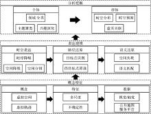
Fig. 1
Research framework for virtual trajectories"
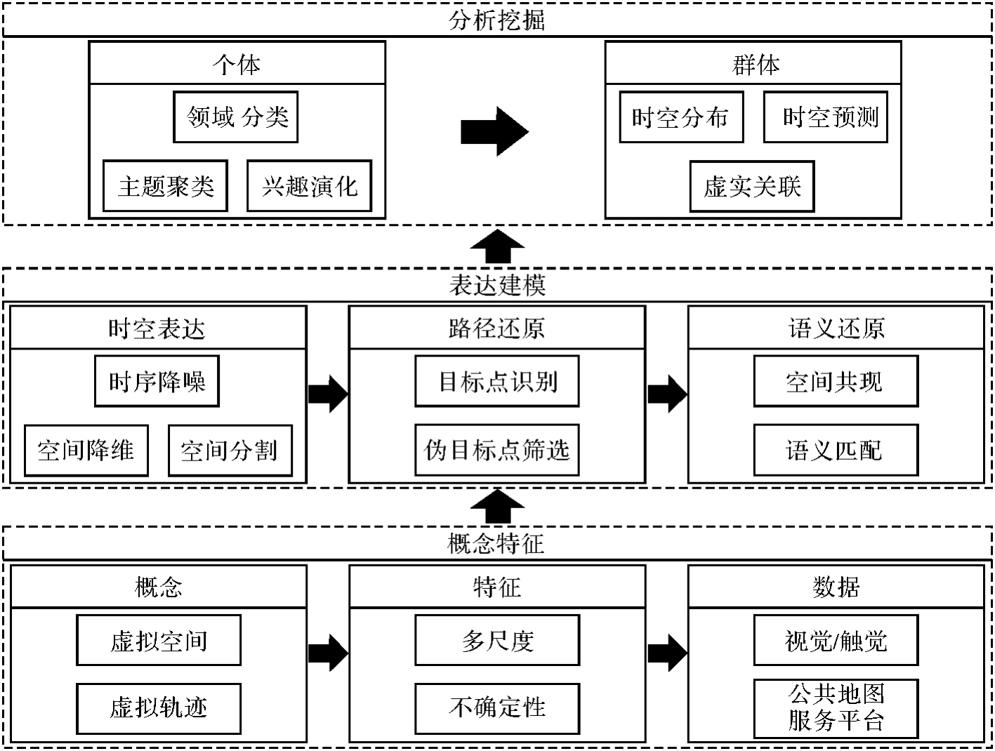

Fig. 2
Pyramid model and virtual trajectories in public map service platforms[27]"
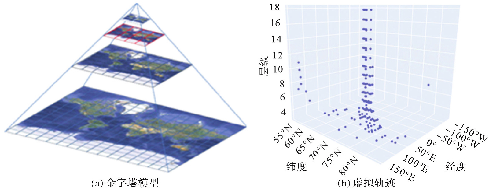
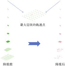
Fig. 3
Spatial dimensionality reduction for virtual trajectories"
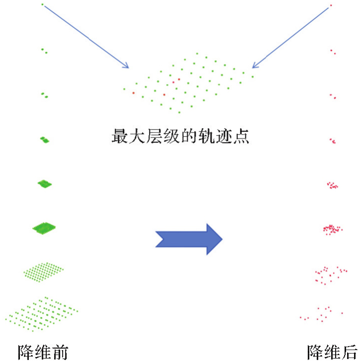

Fig. 4
Spatial segmentation of complex virtual trajectories[25]"


Fig. 5
Browsing targets of virtual trajectories"
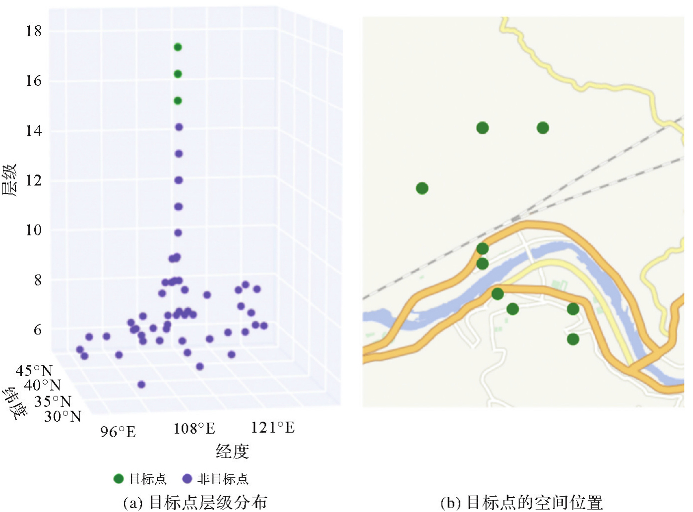

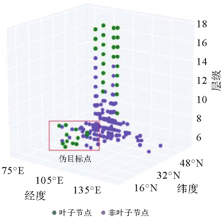
Fig. 6
Pseudo browsing targets distributed at lower layers in the trajectory tree[27]"
| [1] | 周成虎. 地理学赋能网络空间认知[J]. 科技导报, 2023, 41(13): 1. |
| ZHOU Chenghu. Enabling cyberspace cognition with geography[J]. Science & Technology Review, 2023, 41(13): 1. | |
| [2] | 高春东, 郭启全, 江东, 等. 网络空间地理学的理论基础与技术路径[J]. 地理学报, 2019, 74(9): 1709-1722. |
| GAO Chundong, GUO Qiquan, JIANG Dong, et al. The theoretical basis and technical path of cyberspace geography[J]. Acta Geographica Sinica, 2019, 74(9): 1709-1722. | |
| [3] | 江东, 高春东, 郭启全, 等. 论网络空间的地理属性与地理学思维[J]. 地球信息科学学报, 2023, 25(10): 1923-1932. |
| JIANG Dong, GAO Chundong, GUO Qiquan, et al. Geographical properties and thinking of cyberspace[J]. Journal of Geo-information Science, 2023, 25(10): 1923-1932. | |
| [4] | 唐炉亮, 戴领, 任畅, 等. 现实与赛博空间数据相结合的城市活动事件时空建模[J]. 测绘学报, 2019, 48(5): 618-629. |
| TANG Luliang, DAI Ling, REN Chang, et al. Spatio-temporal modeling of city events combining datasets in cyberspace and real space[J]. Acta Geodaetica et Cartographica Sinica, 2019, 48(5): 618-629. | |
| [5] | 陈云海. 社交网络空间时空实体建模与可视化研究[D]. 郑州: 信息工程大学, 2022. |
| CHEN Yunhai. Research on modeling and visualization methods of social cyberspace spatio-temporal entities[D]. Zhengzhou: Information Engineering University, 2022. | |
| [6] | 陈文静, 李锐, 董广胜, 等. 网络地理信息服务中用户空间访问聚集行为研究[J]. 地球信息科学学报, 2021, 23(1): 93-103. |
| CHEN Wenjing, LI Rui, DONG Guangsheng, et al. Research on user spatial access aggregation behavior in network geographic information service[J]. Journal of Geo-information Science, 2021, 23(1): 93-103. | |
| [7] | CHEN Min, CLARAMUNT C, ÇÖLTEKIN A, et al. Artificial intelligence and visual analytics in geographical space and cyberspace: research opportunities and challenges[J]. Earth-Science Reviews, 2023, 241: 104438. |
| [8] | 董广胜, 谢文析, 李锐, 等. 新型冠状病毒感染疫情政策干预下群体虚拟轨迹时空模式差异性研究[J]. 时空信息学报, 2024, 31(1): 104-117. |
| DONG Guangsheng, XIE Wenxi, LI Rui, et al. Study on the spatiotemporal pattern differences of group virtual trajectories under COVID-19 policy interventions[J]. Journal of Spatio-Temporal Information, 2024, 31(1): 104-117. | |
| [9] | 王继龙, 庄姝颖, 缪葱葱, 等. 网络空间信息系统模型与应用[J]. 通信学报, 2020, 41(2): 74-83. |
| WANG Jilong, ZHUANG Shuying, MIAO Congcong, et al. Model and application of cyberspace information system[J]. Journal on Communications, 2020, 41(2): 74-83. | |
| [10] | 董广胜. 公共地图服务平台中访问兴趣时空模式研究[J]. 测绘学报, 2023, 52(10): 1798. |
| DONG Guangsheng. Spatio-temporal pattern mining for users' access interest on public map service platforms[J]. Acta Geodaetica et Cartographica Sinica, 2023, 52(10): 1798. | |
| [11] | 周侗, 龙毅. 我国近期移动地图与互联网地图发展综述[J]. 地理与地理信息科学, 2012, 28(5): 1-5. |
| ZHOU Tong, LONG Yi. Review about recently development of mobile map and internet map in China[J]. Geography and Geo-Information Science, 2012, 28(5): 1-5. | |
| [12] | 张得天, 王佳傲, 陈飞. 国内网络地图服务比较分析研究[J]. 华东师范大学学报(自然科学版), 2017(6): 85-95. |
| ZHANG Detian, WANG Jia'ao, CHEN Fei. A comprehensive study of mapping services in China[J]. Journal of East China Normal University (Natural Science), 2017(6): 85-95. | |
| [13] |
蒋捷, 吴华意, 黄蔚. 国家地理信息公共服务平台“天地图”的关键技术与工程实践[J]. 测绘学报, 2017, 46(10): 1665-1671. DOI: .
doi: 10.11947/j.AGCS.2017.20170357 |
|
JIANG Jie, WU Huayi, HUANG Wei. Key techniques and project practice for establishing national geo-information service platform “Tianditu”[J]. Acta Geodaetica et Cartographica Sinica, 2017, 46(10): 1665-1671. DOI: .
doi: 10.11947/j.AGCS.2017.20170357 |
|
| [14] | 陈欣, 向隆刚, 焦凤伟. 基于众源轨迹的OSM路网转向信息增强[J]. 地球信息科学学报, 2023, 25(10): 1954-1967. |
| CHEN Xin, XIANG Longgang, JIAO Fengwei. Turning information enhancement of OpenStreetMap road network based on crowdsourcing trajectory data[J]. Journal of Geo-information Science, 2023, 25(10): 1954-1967. | |
| [15] | ZHAO Zhiyao, FAN Hongchao. Towards exploring patterns of editing behavior on OpenStreetMap[J]. Journal of Geodesy and Geoinformation Science, 2022, 5(2): 85-97. |
| [16] | BALLATORE A, ARSANJANI J J. Placing Wikimapia: an exploratory analysis[J]. International Journal of Geographical Information Science, 2019, 33(8): 1633-1650. |
| [17] | DONG Guangsheng, LI Rui, WU Huayi, et al. Browsing behavior modeling and browsing interest extraction in the trajectories on web map service platforms[J]. Expert Systems with Applications, 2022, 195: 116590. |
| [18] | 陈迪, 张鹏, 杨洁艳, 等. 在线地图服务日志的大数据分析[J]. 小型微型计算机系统, 2015, 36(1): 33-38. |
| CHEN Di, ZHANG Peng, YANG Jieyan, et al. Big data analysis of web map service log[J]. Journal of Chinese Computer Systems, 2015, 36(1): 33-38. | |
| [19] | 李锐, 沈雨奇, 蒋捷, 等. 公共地图服务中访问热点区域的时空规律挖掘[J]. 武汉大学学报(信息科学版), 2018, 43(9): 1408-1415. |
| LI Rui, SHEN Yuqi, JIANG Jie, et al. Temporal and spatial characteristics of hotspots in public map service[J]. Geomatics and Information Science of Wuhan University, 2018, 43(9): 1408-1415. | |
| [20] | WANG Xiaofei, CHEN Di, LU Gan, et al. Web map service log analysis[C]//Proceedings of 2014 Wireless Algorithms, Systems, and Applications. Harbin: Springer, 2014: 22-33. |
| [21] | 李茹, 李锐, 蒋捷, 等. 网络地图用户访问会话时空特征分析[J]. 数据分析与知识发现, 2019(6): 1-11. |
| LI Ru, LI Rui, JIANG Jie, et al. Spatio-temporal characteristics of WMTS access sessions[J]. Data Analysis and Knowledge Discovery, 2019(6): 1-11. | |
| [22] | XIAO Xiangye, LUO Qiong, LI Zhisheng, et al. A large-scale study on map search logs[J]. ACM Transactions on the Web, 2010, 4(3): 1-33. |
| [23] | BRAGA V G, OLIVEIRA W B D, RODRIGUES V J, et al. Understanding and modeling the behavior of web map users[J]. Journal of Data, Information and Management, 2015, 6: 92-103. |
| [24] | GARCIA R, CASTRO J P, VERDÚ M J, et al. A descriptive model based on the mining of web map server logs for tile prefetching in a web map cache[J]. 2011, 5: 469-476. |
| [25] | DONG Guangsheng, MOU Xiangning, ZHANG Hongping, et al. Browsing target extraction and spatiotemporal preference mining from the complex virtual trajectories[J]. International Journal of Applied Earth Observation and Geoinformation, 2024, 129: 103819. |
| [26] | 武昊, 陈军, 田海波, 等. 全球地理信息公共产品研发的技术发展方向与主要任务[J]. 时空信息学报, 2023, 30(2): 157-166. |
| WU Hao, CHEN Jun, TIAN Haibo, et al. Direction and main task of global geographic information public product research and development[J]. Journal of Spatio-Temporal Information, 2023, 30(2): 157-166. | |
| [27] | 董广胜. 公共地图服务平台中访问兴趣时空模式研究[D]. 武汉: 武汉大学, 2021. |
| DONG Guangsheng. Research on spatio-temporal pattern of visiting interest in public map service platform[D]. Wuhan: Wuhan University, 2021. | |
| [28] | ZHOU Jingbo, PEI Hongbin, WU Haishan. Early warning of human crowds based on query data from Baidu maps: analysis based on Shanghai stampede[M]//Big data support of urban planning and management. Cham: Springer International Publishing, 2017: 19-41. |
| [29] | GUAN Xuefeng, CHENG Bo, SONG Aihong, et al. Modeling users' behavior for testing the performance of a web map tile service[J]. Transactions in GIS, 2014, 18(S1): 109-125. |
| [30] | KRAFKA K, KHOSLA A, KELLNHOFER P, et al. Eye tracking for everyone[C]//Proceedings of 2016 IEEE Conference on Computer Vision and Pattern Recognition. Las Vegas: IEEE, 2016: 2176-2184. |
| [31] | KIEFER P, GIANNOPOULOS I, RAUBAL M, et al. Eye tracking for spatial research: cognition, computation, challenges[J]. Spatial Cognition and Computation, 2017, 17(1/2): 1-19. |
| [32] | ÇÖLTEKIN A, HEIL B, GARLANDINI S, et al. Evaluating the effectiveness of interactive map interface designs: a case study integrating usability metrics with eye-movement analysis[J]. Cartography and Geographic Information Science, 2009, 36(1): 5-17. |
| [33] | OOMS K, DE MAEYER P, FACK V. Study of the attentive behavior of novice and expert map users using eye tracking[J]. Cartography and Geographic Information Science, 2014, 41(1): 37-54. |
| [34] | KRASSANAKIS V, CYBULSKI P. A review on eye movement analysis in map reading process: the status of the last decade[J]. Geodesy and Cartography, 2019, 68(1): 191-209. |
| [35] | 董卫华, 廖华, 詹智成, 等. 2008年以来地图学眼动与视觉认知研究新进展[J]. 地理学报, 2019, 74(3): 599-614. |
| DONG Weihua, LIAO Hua, ZHAN Zhicheng, et al. New research progress of eye tracking-based map cognition in cartography since 2008[J]. Acta Geographica Sinica, 2019, 74(3): 599-614. | |
| [36] | 王成舜, 陈毓芬, 郑束蕾. 顾及眼动数据的网络地图点状符号用户兴趣分析方法[J]. 武汉大学学报(信息科学版), 2018, 43(9): 1429-1437. |
| WANG Chengshun, CHEN Yufen, ZHENG Shulei. User interest analysis method of web map point symbol considering eye movement data[J]. Geomatics and Information Science of Wuhan University, 2018, 43(9): 1429-1437. | |
| [37] | 王成舜, 陈毓芬, 郑束蕾, 等. 基于眼动数据的网络地图界面用户兴趣分析方法[J]. 地理与地理信息科学, 2017, 33(2): 57-62. |
| WANG Chengshun, CHEN Yufen, ZHENG Shulei, et al. User interest analysis method of web map interface based on eye movement data[J]. Geography and Geo-Information Science, 2017, 33(2): 57-62. | |
| [38] | 董卫华, 刘毅龙, 黑巧松, 等. 泛地图空间认知理论与方法研究框架[J]. 武汉大学学报(信息科学版), 2022, 47(12): 2007-2014. |
| DONG Weihua, LIU Yilong, HEI Qiaosong, et al. Research framework of the theories and methods for pan-map spatial cognition[J]. Geomatics and Information Science of Wuhan University, 2022, 47(12): 2007-2014. | |
| [39] | AOIDH E M, BERTOLOTTO M, WILSON D C. Understanding geospatial interests by visualizing map interaction behavior[J]. Information Visualization, 2008, 7(3-4): 275-286. |
| [40] | TAHIR A, MCARDLE G, BERTOLOTTO M. A web-based visualisation tool for analysing mouse movements to support map personalisation[M]//Database systems for advanced applications. Berlin: Springer, 2011: 132-143. |
| [41] | MCARDLE G, TAHIR A, BERTOLOTTO M. Interpreting map usage patterns using geovisual analytics and spatio-temporal clustering[J]. International Journal of Digital Earth, 2015, 8(8): 599-622. |
| [42] | HU Kai, GUI Zhipeng, CHENG Xiaoqiang, et al. Content-based discovery for web map service using support vector machine and user relevance feedback[J]. PLoS One, 2016, 11(11): e0166098. |
| [43] | BRAGA V G, CORREA S L, CARDOSO K V, et al. Data-driven characterization and modeling of web map system workload[J]. IEEE Access, 2021, 9: 26983-27002. |
| [44] | XU Mengwen, WANG Tianyi, WU Zhengwei, et al. Store location selection via mining search query logs of Baidu maps[EB/OL]. [2024-09-03]. https://arxiv.org/abs/1606.03662v1. |
| [45] | OSM tile logs[DB/OL]. [2025-05-10]. https://planet.openstreetmap.org/tile_logs/. |
| [46] | 高强, 张凤荔, 王瑞锦, 等. 轨迹大数据:数据处理关键技术研究综述[J]. 软件学报, 2017, 28(4): 959-992. |
| GAO Qiang, ZHANG Fengli, WANG Ruijin, et al. Trajectory big data: a review of key technologies in data processing[J]. Journal of Software, 2017, 28(4): 959-992. | |
| [47] | ZHENG Yu. Trajectory data mining: an overview[J]. ACM Transactions on Intelligent Systems and Technology, 2015, 6(3): 31-41. |
| [48] | ZHAO Pengfei. Optimization of LSTM ship trajectory prediction based on hybrid genetic algorithm[J]. Journal of Geodesy and Geoinformation Science, 2024, 7(3): 89-102. |
| [49] | DONG Guangsheng, LI Rui, LI Fa, et al. Differences in urban development in China from the perspective of point of interest spatial co-occurrence patterns[J]. ISPRS International Journal of Geo-Information, 2024, 13(1): 24. |
| [50] | DONG Guangsheng, LI Rui, WU Huayi, et al. Learning the spatial co-occurrence for browsing interests extraction of domain users on public map service platforms[J]. Geo-spatial Information Science, 2024, 27(2): 455-474. |
| [51] |
吴华意, 黄蕊, 游兰, 等. 出租车轨迹数据挖掘进展[J]. 测绘学报, 2019, 48(11): 1341-1356. DOI: .
doi: 10.11947/j.AGCS.2019.20190210 |
|
WU Huayi, HUANG Rui, YOU Lan, et al. Recent progress in taxi trajectory data mining[J]. Acta Geodaetica et Cartographica Sinica, 2019, 48(11): 1341-1356. DOI: .
doi: 10.11947/j.AGCS.2019.20190210 |
|
| [52] | CHENG Tao, ZHANG Yang, HAWORTH J. Network SpaceTime AI: concepts, methods and applications[J]. Journal of Geodesy and Geoinformation Science, 2022, 5(3): 78-92. |
| [53] | ZHENG Wei, GE Bin, WANG Chishe. Building a TIN-LDA model for mining microblog users' interest[J]. IEEE Access, 2019, 7: 21795-21806. |
| [54] | FISHER D. Hotmap: looking at geographic attention[J]. IEEE Transactions on Visualization and Computer Graphics, 2007, 13(6): 1184-1191. |
| [55] | QUINN S, GAHEGAN M. A predictive model for frequently viewed tiles in a web map[J]. Transactions in GIS, 2010, 14(2): 193-216. |
| [56] | 陈文静. 网络地理信息服务中用户兴趣迁移模式研究[D]. 武汉: 武汉大学, 2021. |
| CHEN Wenjing. Analysis on user interest transfer in web geographic information service[D]. Wuhan: Wuhan University, 2021. | |
| [57] | 吴华意, 李锐, 周振, 等. 公共地图服务的群体用户访问行为时序特征模型及预测[J]. 武汉大学学报(信息科学版), 2015, 40(10): 1279-1286, 1316. |
| WU Huayi, LI Rui, ZHOU Zhen, et al. Research and prediction on time-sequence characteristics of group-user access behavior in public map service[J]. Geomatics and Information Science of Wuhan University, 2015, 40(10): 1279-1286, 1316. | |
| [58] | LI Rui, LIU Zhaohui, WU Huayi, et al. Hierarchical decomposition method and combination forecasting scheme for access load on public map service platforms[J]. Future Generation Computer Systems, 2018, 87: 213-227. |
| [59] | LI Rui, FAN Jiapei, WU Huayi, et al. Group-user access patterns and tile prefetching based on a time-sequence distribution in cloud-based GIS[J]. Computers, Environment and Urban Systems, 2018, 69: 17-27. |
| [60] | LI Rui, DONG Guangsheng, JIANG Jie, et al. Self-adaptive load-balancing strategy based on a time series pattern for concurrent user access on Web map service[J]. Computers & Geosciences, 2019, 131: 60-69. |
| [61] | DONG Guangsheng, LI Rui, JIANG Jie, et al. Multigranular wavelet decomposition-based support vector regression and moving average method for service-time prediction on web map service platforms[J]. IEEE Systems Journal, 2020, 14(3): 3653-3664. |
| [62] | PARK D J, KIM H J. Prefetch policies for large objects in a Web-enabled GIS application[J]. Data & Knowledge Engineering, 2001, 37(1): 65-84. |
| [63] | LEE D H, KIM J S, KIM S D, et al. Adaptation of a neighbor selection Markov chain for prefetching tiled web GIS data[C]//Proceedings of 2002 Advances in Information Systems. Berlin: Springer, 2002: 213-222. |
| [64] | YEŞILMURAT S, İŞLER V. Retrospective adaptive prefetching for interactive Web GIS applications[J]. GeoInformatica, 2012, 16(3): 435-466. |
| [65] | KANG Y K, KIM K C, KIM Y S. Probability-based tile pre-fetching and cache replacement algorithms for web geographical information systems[C]//Proceedings of 2001 East European Conference on Advances in Databases and Information Systems. Berlin: Springer, 2001: 127-140. |
| [66] | LI Rui, GUO Rui, XU Zhenquan, et al. A prefetching model based on access popularity for geospatial data in a cluster-based caching system[J]. International Journal of Geographical Information Science, 2012, 26(10): 1831-1844. |
| [67] | PAN Shaoming, CHONG Yanwen, ZHANG Hang, et al. A global user-driven model for tile prefetching in web geographical information systems[J]. PLoS One, 2017, 12(1): e0170195. |
| [68] | SHAW S L. Time geography in a hybrid physical-virtual world[J]. Journal of Geographical Systems, 2023, 25(3): 339-356. |
| [69] | REN Fang, KWAN M P. Geovisualization of human hybrid activity-travel patterns[J]. Transactions in GIS, 2007, 11(5): 721-744. |
| [70] | LI Chunjiang, THULIN E, CHAI Yanwei. Understanding the hybridization of everyday activities from a time-geographic perspective[J]. Annals of the American Association of Geographers, 2024, 114(1): 185-199. |
| [1] | Biao HE, Haojia LIN, Renzhong GUO, Xi KUAI, Ding MA, Chen ZHANG. Visual perception-based quantitative calculation of 3D spatial similarity relations [J]. Acta Geodaetica et Cartographica Sinica, 2026, 55(1): 138-153. |
| [2] | Shuai FANG, Jiaen LIU, Jing ZHANG. Spatio-temporal fusion algorithm based on adaptive reference feature incorporation and multi-scale feature aggregation [J]. Acta Geodaetica et Cartographica Sinica, 2025, 54(8): 1476-1488. |
| [3] | Haojia LIN, Renzhong GUO, Biao HE, Xi KUAI, Ding MA, Chengpeng LI. Visual-perception-oriented LOD adaptive visualization for realistic 3D building scenes [J]. Acta Geodaetica et Cartographica Sinica, 2025, 54(6): 1054-1070. |
| [4] | Zibo DONG, Jingxue WANG, Lijing BU, Lin FANG, Zhenghui XU. MAFNet: building extraction method from remote sensing images based on multi-scale atrous fusion network [J]. Acta Geodaetica et Cartographica Sinica, 2025, 54(6): 1094-1106. |
| [5] | Youneng SU, Qing XU, Qun SUN, Xinming ZHU, Fubing ZHANG, Bo LIU. A method for automatic buildings aggregation constrained by proximity edges [J]. Acta Geodaetica et Cartographica Sinica, 2025, 54(3): 563-576. |
| [6] | Zhekun HUANG, Haizhong QIAN, Zhongxiang CAI, Xiao WANG, Junwei WANG, Linghui KONG. A multi-scale mesh river system classification matching method based on graph neural network [J]. Acta Geodaetica et Cartographica Sinica, 2025, 54(2): 371-384. |
| [7] | Xin YAN, Li SHEN, Junjie PAN, Yanshuai DAI, Jicheng WANG, Xiaoli ZHENG, Zhi-lin LI. Weakly supervised building change detection integrating multi-scale feature fusion and spatial refinement for high resolution remote sensing images [J]. Acta Geodaetica et Cartographica Sinica, 2024, 53(8): 1586-1597. |
| [8] | Tao XU, Yuanwei YANG, Xianjun GAO, Zhiwei WANG, Yue PAN, Shaohua LI, Lei XU, Yanjun WANG, Bo LIU, Jing YU, Fengmin WU, Haoyu SUN. Integrated graph convolution and multi-scale features for the overhead catenary system point cloud semantic segmentation [J]. Acta Geodaetica et Cartographica Sinica, 2024, 53(8): 1624-1633. |
| [9] | Jun YANG, Hengjing XIE, Hongchao FAN, Haowen YAN. Multi-scale entropy neural architecture search for object detection in remote sensing images [J]. Acta Geodaetica et Cartographica Sinica, 2024, 53(7): 1384-1400. |
| [10] | Huimin LIU, Chenwei ZHANG, Kaiqi CHEN, Min DENG, Chong PENG. Deep learning-based spatio-temporal prediction and uncertainty assessment of urban PM2.5 distribution [J]. Acta Geodaetica et Cartographica Sinica, 2024, 53(4): 750-760. |
| [11] | LIU Huanling, YANG Weiran, ZHANG Fang, WEN Hanjiang, HU Minzhang, JIANG Tao, LIN Wenqi, LI Chenxi. Multi-scale analysis of gravity anomaly models in sea area [J]. Acta Geodaetica et Cartographica Sinica, 2024, 53(2): 274-285. |
| [12] | Genyun SUN, Chao SUN, Aizhu ZHANG. Road extraction networks fusing multiscale and edge features [J]. Acta Geodaetica et Cartographica Sinica, 2024, 53(12): 2233-2243. |
| [13] | Shiyan PANG, Jingjing HAO, Zhiqi ZUO, Jingjing LAN, Xiangyun HU. A high-resolution remote sensing images change detection method via the integration of dense connections and self-attention mechanisms [J]. Acta Geodaetica et Cartographica Sinica, 2024, 53(12): 2244-2253. |
| [14] | JIANG Baode, HANG Wei, XU Shaofen, WU Yong. Multi-scale building instance refinement extraction from remote sensing images by fusing with decentralized adaptive attention mechanism [J]. Acta Geodaetica et Cartographica Sinica, 2023, 52(9): 1504-1514. |
| [15] | WEI Chuntao, GONG Cheng, ZHOU Yongxu. A change detection network with joint spatial constraints and differential feature aggregation [J]. Acta Geodaetica et Cartographica Sinica, 2023, 52(9): 1538-1547. |
| Viewed | ||||||
|
Full text |
|
|||||
|
Abstract |
|
|||||