

Acta Geodaetica et Cartographica Sinica ›› 2026, Vol. 55 ›› Issue (8): 1369-1381.doi: 10.11947/j.AGCS.2026.20250495
• Geodesy and Navigation • Previous Articles
Hengyi Yin1( ), Yun Shi1(), Bin Wang2, Zhe Hui2,3, Chang Liu4, Hao Yu1, Xiaohui Song1, Xuliang Wei1
Received:2025-11-24
Revised:2026-07-23
Published:2026-09-09
Contact:
Yun Shi
E-mail:yinhengyi@foxmail.com;shiyun0908@hotmail.com
About author:Yin Hengyi (1994—), male, PhD candidate, majors in GNSS/InSAR data fusion and applications. E-mail: yinhengyi@foxmail.com
Supported by:CLC Number:
Hengyi Yin, Yun Shi, Bin Wang, Zhe Hui, Chang Liu, Hao Yu, Xiaohui Song, Xuliang Wei. Accuracy and applicability assessment of joint PWV retrieval using CRA40 and BDS-3: a case study of the Shaanxi CORS network[J]. Acta Geodaetica et Cartographica Sinica, 2026, 55(8): 1369-1381.
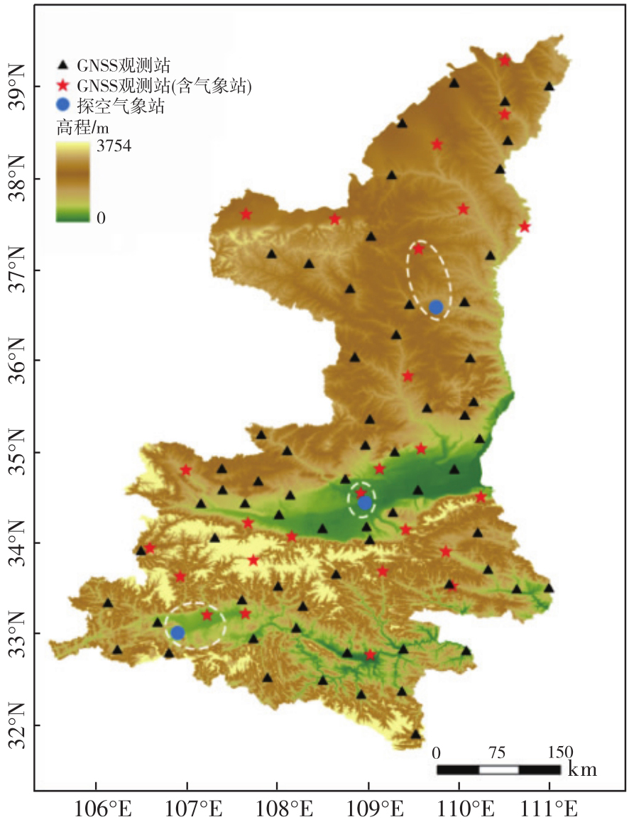
Fig. 1
Distribution of observation stations"

Tab. 1
Configuration of key parameters for GAMIT data processing"
| 项目 | 设置 |
|---|---|
| 接收机类型 | Trimble ALLOY |
| 天线类型 | TRM159900 |
| 卫星轨道星历 | 精密星历WHU |
| 天线相位中心改正 | ngs20. atx |
| 采样间隔 | 30 s |
| 周跳自动探测与修复 | LC_AUTCLN |
| 频段组合 | 高频:B1I;低频:B3I |
| 解算类型 | Baseline |
| 截止高度角 | 10° |
| 大气模型 | VMF1 |
| 天顶延迟估计参数 | 13 |
| 海潮模型 | FES2014 |
| 剔除卫星 | PRN1—5、31、47—49、56—58 |
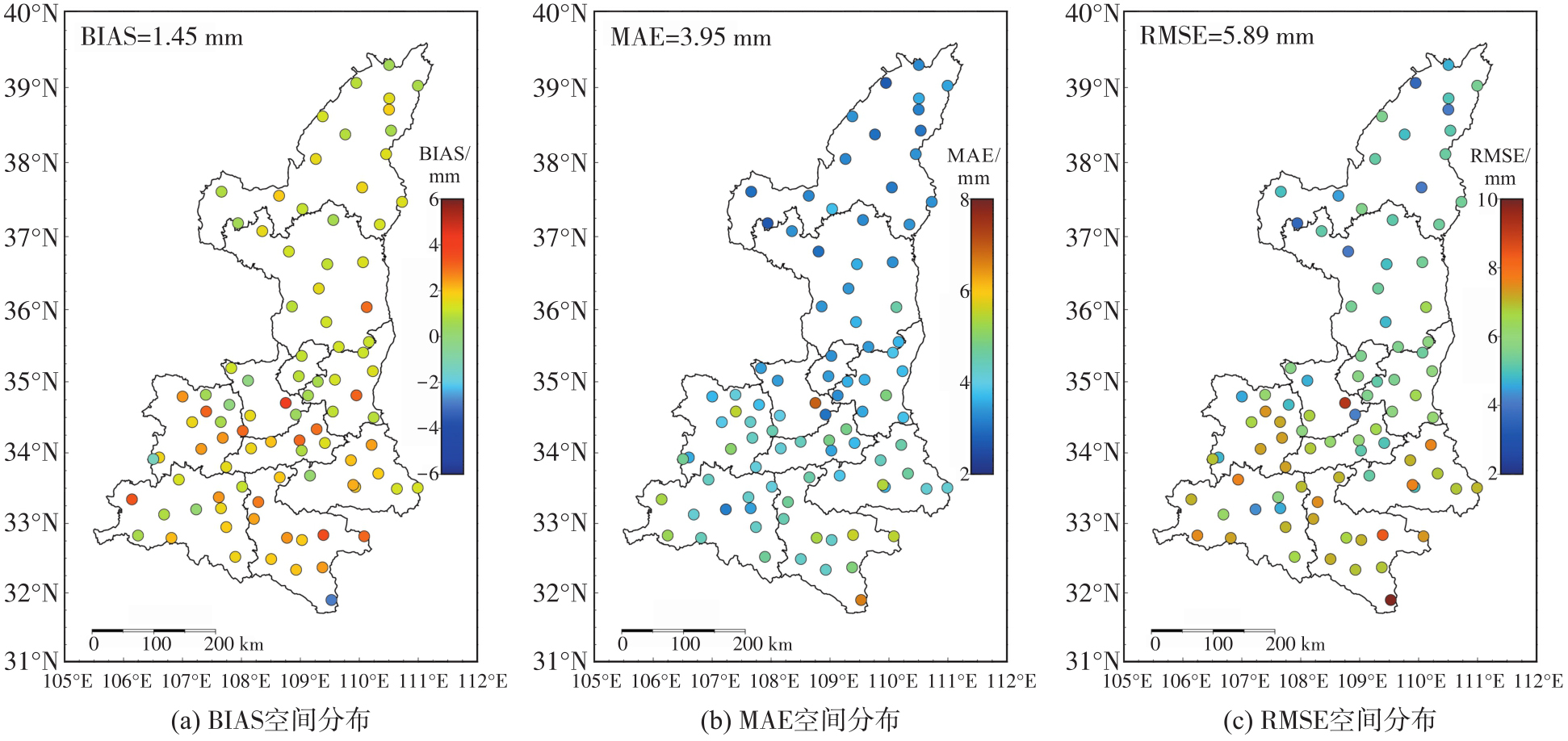
Fig. 2
Spatial distribution of BDS-ZTD retrieval accuracy"
Tab. 2
Accuracy statistics of BDS-PWV"
| 站点 | BIAS/mm | MAE/mm | RMSE/mm | R2 | 距离/km |
|---|---|---|---|---|---|
| 延安 | 0.58 | 2.28 | 3.25 | 0.95 | 72.3 |
| 泾河 | -0.49 | 1.14 | 1.53 | 0.99 | 12.9 |
| 汉中 | -0.89 | 1.48 | 1.90 | 0.99 | 23.7 |
Fig. 3
Precision of surface pressure stations"
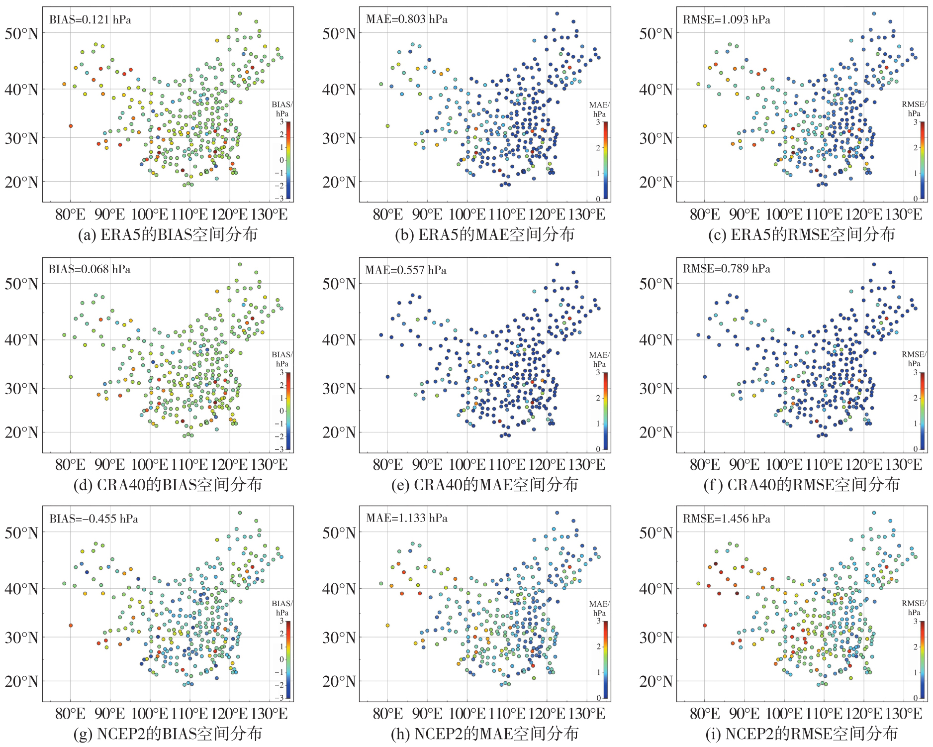
Fig. 4
Precision distribution of Tm stations"

Fig. 5
Accuracy of PWV retrieved by BDS-3 combined with three reanalysis datasets"
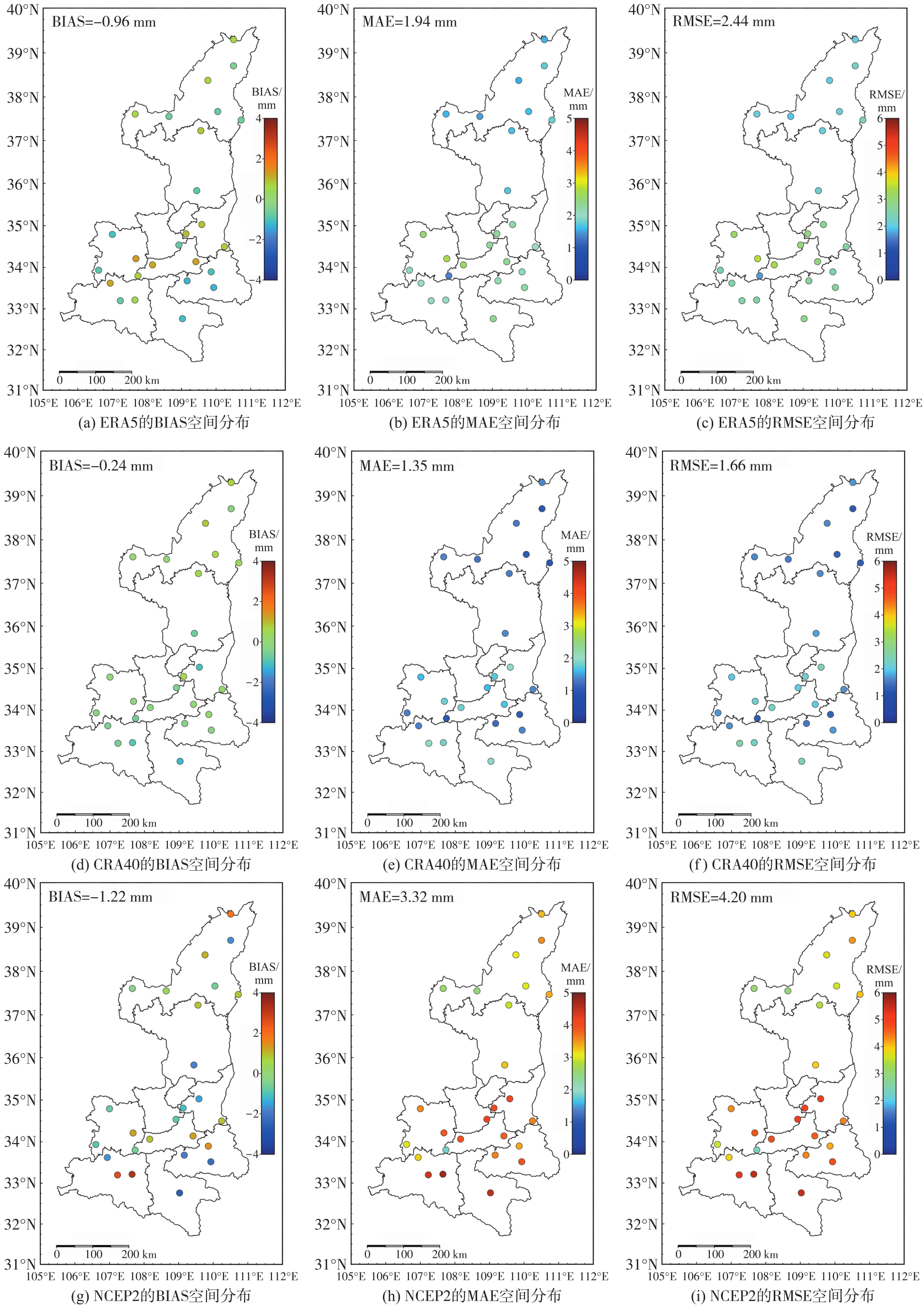
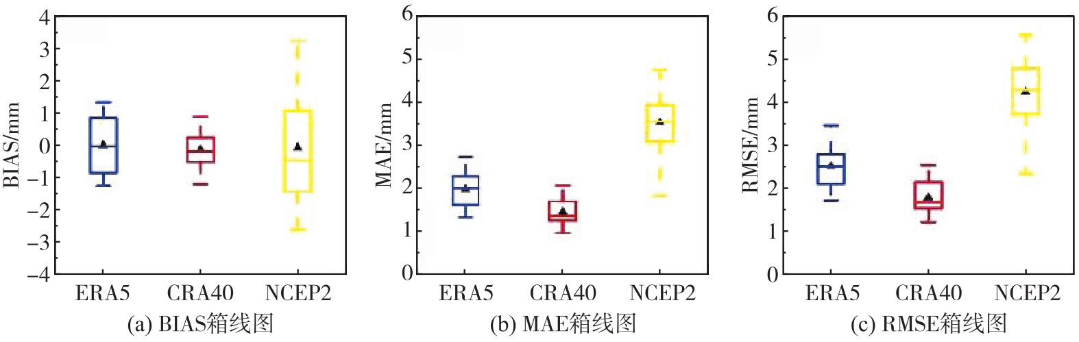
Fig. 6
Box plot of PWV retrieved by BDS-3 combined with three reanalysis datasets"
Tab. 3
Accuracy statistics of PWV retrieved by BDS-3 combined reanalysis dataset in different seasons"
| 季节 | ERA5 | CRA40 | NCEP2 | ||||||
|---|---|---|---|---|---|---|---|---|---|
| BIAS | MAE | RMSE | BIAS | MAE | RMSE | BIAS | MAE | RMSE | |
| 春季 | -0.43 | 1.86 | 2.37 | 0.12 | 1.21 | 1.53 | -2.77 | 2.95 | 3.56 |
| 夏季 | -2.14 | 2.40 | 2.86 | -1.55 | 1.69 | 1.97 | -4.87 | 5.03 | 5.45 |
| 秋季 | -1.16 | 2.01 | 2.57 | 0.66 | 1.39 | 1.71 | 1.87 | 2.99 | 3.72 |
| 冬季 | -0.12 | 1.49 | 1.96 | -0.18 | 1.11 | 1.41 | 0.88 | 2.29 | 3.09 |
Tab. 4
Accuracy statistics of PWV retrieved by BDS-3 combined reanalysis dataset in different regions"
| 数据集 | 评估指标 | 陕北 | 关中 | 陕南 |
|---|---|---|---|---|
| ERA5 | BIAS | -0.74 | -0.98 | -1.18 |
| MAE | 1.63 | 2.10 | 2.09 | |
| RMSE | 2.12 | 2.66 | 2.59 | |
| CRA40 | BIAS | -0.34 | -0.17 | -0.24 |
| MAE | 1.38 | 1.46 | 1.21 | |
| RMSE | 1.69 | 1.79 | 1.52 | |
| NCEP2 | BIAS | -0.92 | -1.03 | -1.86 |
| MAE | 2.90 | 3.46 | 3.64 | |
| RMSE | 3.53 | 4.17 | 4.36 |
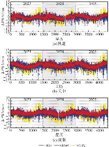
Fig. 7
Difference series of PWV stations in three regions"

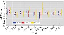
Fig. 8
Box plot of ΔPWV for three reanalysis datasets"
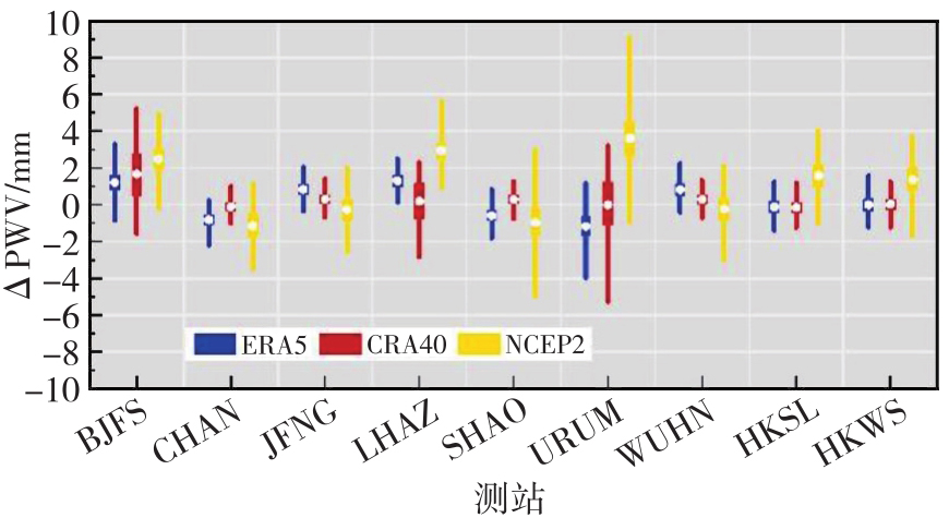
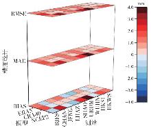
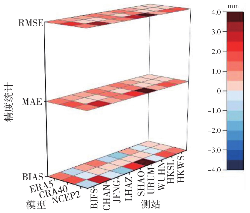
Fig. 9
Accuracy statistics of PWV retrieved from three reanalysis datasets"
| [1] | 王永前, 施建成, 刘志红, 等. 利用微波辐射计AMSR-E的京津冀地区大气水汽反演[J]. 武汉大学学报(信息科学版), 2015, 40(4): 479-486. |
| Wang Yongqian, Shi Jiancheng, Liu Zhihong, et al. Passive microwave remote sensing of precipitable water vapor over Beijing-Tianjin-Hebei region based on AMSR-E[J]. Geomatics and Information Science of Wuhan University, 2015, 40(4): 479-486. | |
| [2] | Zhao Qingzhi, Ma Zhi, Yin Jinfang, et al. General method of precipitable water vapor retrieval from remote sensing satellite near-infrared data[J]. Remote Sensing of Environment, 2024, 308: 114180. |
| [3] | 刘盼, 刘智敏, 张明敏, 等. 不同IGS星历产品对地基GPS反演水汽的影响[J]. 测绘科学, 2018, 43(12): 17-22. |
| Liu Pan, Liu Zhimin, Zhang Mingmin, et al. Influence of different IGS ephemeris products on GPS of precipitable water vapor inversion[J]. Science of Surveying and Mapping, 2018, 43(12): 17-22. | |
| [4] | 马华锋, 李黎, 张志杰, 等. 基于GNSS、ERA5和机器学习的区域天顶对流层延迟校正和大气可降水量预测模型[J]. 地球物理学报, 2026, 69(1): 55-68. |
| Ma Huafeng, Li Li, Zhang Zhijie, et al. The regional zenith tropospheric delay correction and precipitable water vapor prediction models based on the GNSS, ERA5 and machine learning[J]. Chinese Journal of Geophysics, 2026, 69(1): 55-68. | |
| [5] | Bevis M, Businger S, Herring T A, et al. GPS meteorology: remote sensing of atmospheric water vapor using the global positioning system[J]. Journal of Geophysical Research: Atmospheres, 1992, 97(D14): 15787-15801. |
| [6] | 杨鹏飞, 赵庆志, 苏静, 等. 黄土高原地区PWV影响因素分析及精度评定[J]. 武汉大学学报(信息科学版), 2022, 47(9): 1470-1478. |
| Yang Pengfei, Zhao Qingzhi, Su Jing, et al. Analysis of influencing factors and accuracy evaluation of PWV in the Loess Plateau[J]. Geomatics and Information Science of Wuhan University, 2022, 47(9): 1470-1478. | |
| [7] | 尹恒毅, 郭春喜, 姚顽强, 等. 不同对流层天顶延迟模型在陕西地区的精度及适用性分析[J]. 大地测量与地球动力学, 2020, 40(4): 391-394. |
| Yin Hengyi, Guo Chunxi, Yao Wanqiang, et al. Accuracy and applicability of different tropospheric zenith delay models in Shaanxi province[J]. Journal of Geodesy and Geodynamics, 2020, 40(4): 391-394. | |
| [8] | 施闯, 周凌昊, 范磊, 等. 利用北斗/GNSS观测数据分析“21•7”河南极端暴雨过程[J]. 地球物理学报, 2022, 65(1): 186-196. |
| Shi Chuang, Zhou Linghao, Fan Lei, et al. Analysis of “21•7” extreme rainstorm process in Henan province using BeiDou/GNSS observation[J]. Chinese Journal of Geophysics, 2022, 65(1): 186-196. | |
| [9] | 周苏娅, 闻德保, 梅登奎. 连续台风时期香港区域的水汽变化分析[J]. 大地测量与地球动力学, 2020, 40(1): 82-86. |
| Zhou Suya, Wen Debao, Mei Dengkui. Analysis of water vapor variation over Hong Kong region during successive typhoons[J]. Journal of Geodesy and Geodynamics, 2020, 40(1): 82-86. | |
| [10] | Vázquez B G E, Grejner-Brzezinska D A. GPS-PWV estimation and validation with radiosonde data and numerical weather prediction model in Antarctica[J]. GPS Solutions, 2013, 17(1): 29-39. |
| [11] | Chen Qiuli, Yang Hui, Chen Zhonggui, et al. Solar radiation pressure modeling and application of BDS satellites[J]. Journal of Geodesy and Geoinformation Science, 2020, 3(2): 45-52. |
| [12] | 孙鹏. GNSS实时水汽反演关键算法研究[D]. 徐州: 中国矿业大学, 2022. |
| Sun Peng. An investigation of real-time GNSS precipitable water vapor retrievals[D]. Xuzhou: China University of Mining and Technology, 2022. | |
| [13] | Zhou Linghao, Fan Lei, Shi Chuang, et al. Comprehensive analysis of zenith tropospheric delay and precipitable water vapor retrieved from BDS-3 B1C and B2a signals[J]. Measurement, 2025, 242: 116079. |
| [14] | 高志钰, 李建章, 刘彦军, 等. 利用BDS数据反演大气可降水量及其精度分析[J]. 测绘通报, 2019(5): 35-38, 47. |
| Gao Zhiyu, Li Jianzhang, Liu Yanjun, et al. Research on the accuracy of atmospheric precipitable water vapor with BDS[J]. Bulletin of Surveying and Mapping, 2019(5): 35-38, 47. | |
| [15] | 邹玉学, 朱腊腊, 詹金瑞, 等. 广州CORS BDS-3的大气可降水量反演[J]. 导航定位学报, 2024, 12(6): 145-152. |
| Zou Yuxue, Zhu Lala, Zhan Jinrui, et al. Precipitable water vapor inversion based on BDS-3 in Guangzhou CORS[J]. Journal of Navigation and Positioning, 2024, 12(6): 145-152. | |
| [16] | Wu Zhilu, Lu Cuixian, Han Xinjuan, et al. Real-time shipborne multi-GNSS atmospheric water vapor retrieval over the South China Sea[J]. GPS Solutions, 2023, 27(4): 179. |
| [17] | 赵琨, 罗力, 杨凤芸. 利用北斗CORS反演大气可降水量的精度分析[J]. 测绘科学, 2021, 46(11): 12-17. |
| Zhao Kun, Luo Li, Yang Fengyun. Accuracy analysis of precipitable water vapor retrieved by BeiDou CORS[J]. Science of Surveying and Mapping, 2021, 46(11): 12-17. | |
| [18] | 王建敏, 董宏祥, 席克伟, 等. GPT2模型在大气可降水量中的估计研究[J]. 导航定位学报, 2018, 6(3): 98-102. |
| Wang Jianmin, Dong Hongxiang, Xi Kewei, et al. Estimation of precipitable water vapor with GPT2model[J]. Journal of Navigation and Positioning, 2018, 6(3): 98-102. | |
| [19] | Wang Zhaoyang, Zhou Xinghua, Xing Zhe, et al. Comparison of GPS-based precipitable water vapor using various reanalysis datasets for the coastal regions of China[J]. Theoretical and Applied Climatology, 2019, 137(1/2): 1541-1553. |
| [20] | Jade S, Vijayan M S M. GPS-based atmospheric precipitable water vapor estimation using meteorological parameters interpolated from NCEP global reanalysis data[J]. Journal of Geophysical Research Atmospheres, 2008, 113(D3): D03106. |
| [21] | He Qimin, Shen Zhen, Wan Moufeng, et al. Precipitable water vapor converted from GNSS-ZTD and ERA5 datasets for the monitoring of tropical cyclones[J]. IEEE Access, 2020, 8: 87275-87290. |
| [22] | 赵庆志, 刘康, 李祖锋, 等. GNSS和非实测气象参数的PWV反演方法及其精度评估[J]. 武汉大学学报(信息科学版), 2024, 49(3): 453-464. |
| Zhao Qingzhi, Liu Kang, Li Zufeng, et al. PWV inversion method based on GNSS and non-measured meteorological parameters and accuracy evaluation[J]. Geomatics and Information Science of Wuhan University, 2024, 49(3): 453-464. | |
| [23] | 姜卫平, 鄂栋臣, 詹必伟, 等. 南极板块运动新模型的确定与分析[J]. 地球物理学报, 2009, 52(1): 41-49. |
| Jiang Weiping, Dongchen E, Zhan Biwei, et al. New model of Antarctic plate motion and its analysis[J]. Chinese Journal of Geophysics, 2009, 52(1): 41-49. | |
| [24] |
黄良珂. 顾及时空因素的高精度全球对流层关键参量模型构建研究[J]. 测绘学报, 2023, 52(9): 1609. DOI: .
doi: 10.11947/j.AGCS.2023.20220164 |
|
Huang Liangke. Development of the high-precision global models for the key parameters of troposphere considering spatiotemporal factors[J]. Acta Geodaetica et Cartographica Sinica, 2023, 52(9): 1609. DOI: .
doi: 10.11947/j.AGCS.2023.20220164 |
|
| [25] | 上官明, 程旭, 潘雄, 等. 基于GNSS的再分析资料对流层延迟精度评估[J]. 地球物理学报, 2023, 66(3): 939-950. |
| Shangguan Ming, Cheng Xu, Pan Xiong, et al. Assessments of global tropospheric delay retrieval from reanalysis based on GNSS data[J]. Chinese Journal of Geophysics, 2023, 66(3): 939-950. | |
| [26] | Saastamoinen J. Atmospheric correction for the troposphere and stratosphere in radio ranging satellites[M]//The use of artificial satellites for geodesy. Washington, D. C.: American Geophysical Union, 2013: 247-251. |
| [27] |
姚宜斌, 赵庆志. GNSS对流层水汽监测研究进展与展望[J]. 测绘学报, 2022, 51(6): 935-952. DOI: .
doi: 10.11947/j.AGCS.2022.20220039 |
|
Yao Yibin, Zhao Qingzhi. Research progress and prospect of monitoring tropospheric water vapor by GNSS technique[J]. Acta Geodaetica et Cartographica Sinica, 2022, 51(6): 935-952. DOI: .
doi: 10.11947/j.AGCS.2022.20220039 |
|
| [28] |
黄良珂, 彭华, 刘立龙, 等. 顾及垂直递减率函数的中国区域大气加权平均温度模型[J]. 测绘学报, 2020, 49(4): 432-442. DOI: .
doi: 10.11947/j.AGCS.2020.20190168 |
|
Huang Liangke, Peng Hua, Liu Lilong, et al. An empirical atmospheric weighted mean temperature model considering the lapse rate function for China[J]. Acta Geodaetica et Cartographica Sinica, 2020, 49(4): 432-442. DOI: .
doi: 10.11947/j.AGCS.2020.20190168 |
|
| [29] | 莫智翔, 黄玲, 郭希, 等. 利用ERA5资料进行桂林地区GNSS水汽反演精度分析[J]. 南京信息工程大学学报(自然科学版), 2021, 13(2): 131-137. |
| Mo Zhixiang, Huang Ling, Guo Xi, et al. Accuracy of ERA5 reanalysis data in retrieving GNSS precipitable water vapor over Guilin[J]. Journal of Nanjing University of Information Science & Technology (Natural Science Edition), 2021, 13(2): 131-137. | |
| [30] | 张文渊, 郑南山, 张书毕, 等. 附加高水平分辨率PWV约束的GNSS水汽层析算法[J]. 武汉大学学报(信息科学版), 2021, 46(11): 1627-1635. |
| Zhang Wenyuan, Zheng Nanshan, Zhang Shubi, et al. GNSS water vapor tomography algorithm constrained with high horizontal resolution PWV data[J]. Geomatics and Information Science of Wuhan University, 2021, 46(11): 1627-1635. | |
| [31] | Yao Yibin, Xu Chaoqian, Shi Junbo, et al. ITG: a new global GNSS tropospheric correction model[J]. Scientific Reports, 2015, 5: 10273. |
| [32] | Yan Rui, Liao Jiaqiang, Yang Jie, et al. Multi-hour and multi-site air quality index forecasting in Beijing using CNN, LSTM, CNN-LSTM, and spatiotemporal clustering[J]. Expert Systems with Applications, 2021, 169: 114513. |
| [33] | 熊昌盛, 韦仕川, 栾乔林, 等. 基于Morans'I分析方法的耕地质量空间差异研究:以广东省广宁县为例[J]. 资源科学, 2014, 36(10): 2066-2074. |
| Xiong Changsheng, Wei Shichuan, Luan Qiaolin, et al. Spatial pattern disparity and cultivated land quality based on moran's I analysis[J]. Resources Science, 2014, 36(10): 2066-2074. | |
| [34] | 朱丹, 董有福. 利用局部Moran's I指数进行DEM地形简化[J]. 武汉大学学报(信息科学版), 2015, 40(2): 280-284. |
| Zhu Dan, Dong Youfu. Terrain simplification from grid DEMs based on local Moran's I index[J]. Geomatics and Information Science of Wuhan University, 2015, 40(2): 280-284. |
| [1] | Jingzhu ZHAO, Chuang SHI, Lei FAN, Shiwei GUO, Tao ZHANG. Unified estimation and correction method for multi-form code bias using BDS-3 data [J]. Acta Geodaetica et Cartographica Sinica, 2026, 55(6): 1047-1057. |
| [2] | Jian CHEN, Jiahui WANG, Xingwang ZHAO, Chao LIU, Chunyang LIU, Xuexiang YU. Single-epoch RTK positioning optimization method based on BDS-3/Galileo multi-frequency ionosphere-reduced combinations [J]. Acta Geodaetica et Cartographica Sinica, 2025, 54(12): 2153-2167. |
| [3] | Chaolong YAO, Hongrui YOU, Xuanhui HE, Junya LU, Yiqian XIE, Qiong LI, Shuang ZHU, Zhicai LUO. A composite drought index derived from a combination of GNSS PWV/vertical deformation and GRACE/GRACE-FO data [J]. Acta Geodaetica et Cartographica Sinica, 2025, 54(10): 1757-1768. |
| [4] | Fei YANG, Yingying WANG, Zhicai LI, Boyao YU, Junli WU, Yunchang CAO, Shu ZHANG. Analysis of heavy rainstorm in Beijing in 2023 based on GNSS observations [J]. Acta Geodaetica et Cartographica Sinica, 2025, 54(1): 14-25. |
| [5] | Yang LIU, Guang YANG, Xiaohui CHENG, Xiao ZHANG. Rapid single point positioning enhancement service and application based on urban CORS [J]. Acta Geodaetica et Cartographica Sinica, 2024, 53(9): 1706-1714. |
| [6] | Chunhua JIANG, Xiang GAO, Shuaimin WANG, Huizhong ZHU, Shaoni CHEN, Guangsheng LIU. A global vertical correction model of PWV considering the spatial-temporal variation of decay coefficient [J]. Acta Geodaetica et Cartographica Sinica, 2024, 53(5): 889-899. |
| [7] | Tian HE, Guojie MENG, Weiwei WU, Xiaoning SU, Guoqiang ZHAO, Congmin WEI, Zhihua DONG. Preliminary analysis to positioning precision and crustal movement of BDS-3 data recorded by the China seismic experiment site [J]. Acta Geodaetica et Cartographica Sinica, 2024, 53(4): 653-665. |
| [8] | HU Chao, WANG Qianxin. GNSS ultra-rapid orbit and clock offset estimation method with the aid of the constraint of BDS-3 onboard clock [J]. Acta Geodaetica et Cartographica Sinica, 2024, 53(3): 413-424. |
| [9] | ZHAO Qingzhi, MA Zhi, YAO Yibin, DU Zheng. GNSS-assisted FY-3 satellite atmospheric precipitable water retrieval method [J]. Acta Geodaetica et Cartographica Sinica, 2024, 53(2): 306-320. |
| [10] | Chao HU, Qianxin WANG. BDS-3/GNSS satellite ultra-rapid clock offsets estimation model with the aid of onboard clock states solution [J]. Acta Geodaetica et Cartographica Sinica, 2024, 53(12): 2268-2281. |
| [11] | Qimin HE, Kefei ZHANG, Li LI, Dajun LIAN, Wei ZHAO, Guodong CHEN, Erjiang FU, Rui WANG. A four-parameter model for estimating typhoon motion states based on time difference of PWV arrival [J]. Acta Geodaetica et Cartographica Sinica, 2024, 53(11): 2125-2137. |
| [12] | Mengyao WANG, Shubi ZHANG, Wenyuan ZHANG, Yang LIU. MODIS PWV neural network differential correction model integrating multiple nonlinear factors [J]. Acta Geodaetica et Cartographica Sinica, 2024, 53(11): 2138-2148. |
| [13] | Zhaohui XIONG, Dunyong ZHENG, Yibin YAO, Changyong HE, Sichun LONG, Shide LU, Jian ZHOU, Xiangen LAI. An improved model for short-term qualitative rainfall prediction combined with GNSS PWV and meteorological parameters [J]. Acta Geodaetica et Cartographica Sinica, 2024, 53(10): 1981-1992. |
| [14] | ZHA Jiuping, ZHANG Baocheng, LIU Teng, ZHANG Xiao, HOU Pengyu, YUAN Yunbin, LI Zishen. Undifferenced and uncombined PPP-RTK aided by BDS-3 PPP-B2b precise orbits [J]. Acta Geodaetica et Cartographica Sinica, 2023, 52(9): 1449-1459. |
| [15] | LI Yang, WANG Ningbo, LI Zishen, WANG Liang, LI Zongyi. BDS-3 satellite difference code bias estimation with satellite phase center offset correction applied [J]. Acta Geodaetica et Cartographica Sinica, 2023, 52(9): 1460-1468. |
| Viewed | ||||||
|
Full text |
|
|||||
|
Abstract |
|
|||||
