

Acta Geodaetica et Cartographica Sinica ›› 2024, Vol. 53 ›› Issue (10): 1896-1909.doi: 10.11947/j.AGCS.2024.20230272.
• Major Satellite Surveying and Mapping Project “LuTan-1” • Previous Articles Next Articles
Mingliang TAO1,( ), Jieshuang LI1, Yanyang LIU2(), Junli CHEN3, Yifei LIU1, Jiawang LI1
Received:2023-07-03
Online:2024-11-26
Published:2024-11-26
Contact:
Yanyang LIU
E-mail:mltao@nwpu.edu.cn;yanyangliu0510@163.com
About author:TAO Mingliang (1989—), male, PhD, professor, majors in frequency management and RFI mitigation. E-mail: mltao@nwpu.edu.cn
Supported by:CLC Number:
Mingliang TAO, Jieshuang LI, Yanyang LIU, Junli CHEN, Yifei LIU, Jiawang LI. Mitigation of radio frequency interference signatures and image quality enhancement for L-band differential interferometric SAR satellite images[J]. Acta Geodaetica et Cartographica Sinica, 2024, 53(10): 1896-1909.
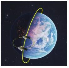
Fig.1
Working illustration of LT-1"

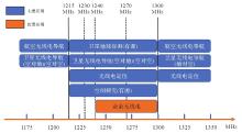
Fig.2
Frequency allocation in L-band for earth exploration-satellite service (active) in ITU region 3"

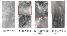
Fig.3
Comparison of LT-1 SLC images with and without RFI artifacts"
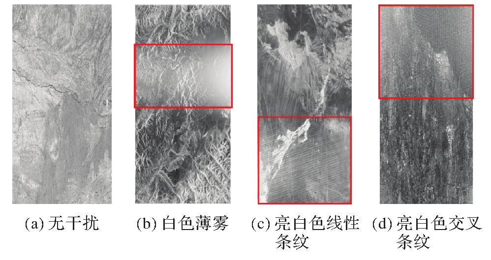
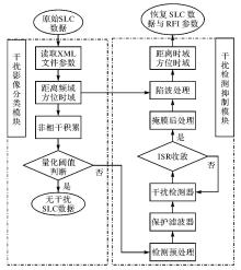
Fig.4
Flowchart of RFI mitigation and image enhancement for LT-1 system"
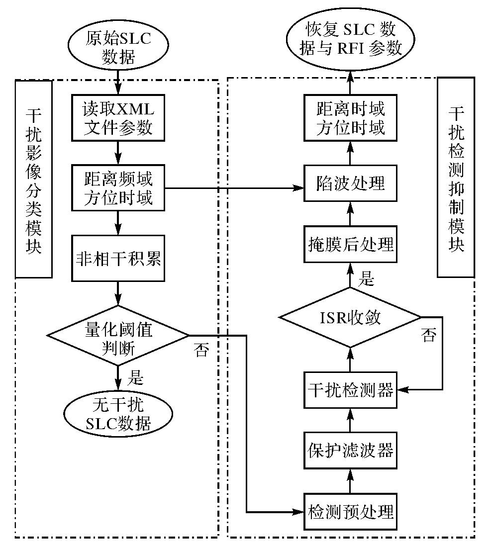
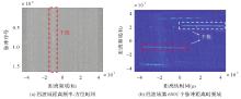
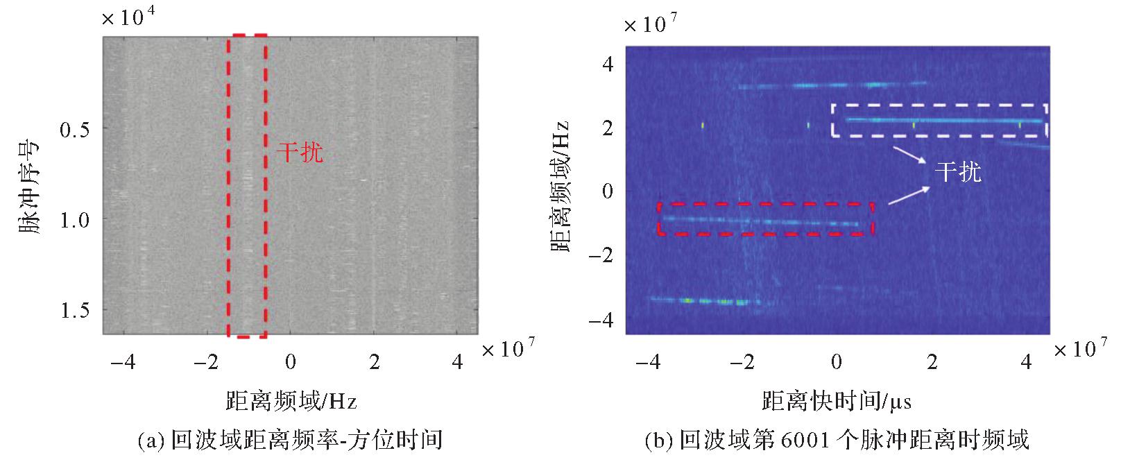
Fig.5
Illustration of a particular RFI case in echo domain"
Tab.1
Main system parameters for LT-1"
| 参数 | LT-1卫星 |
|---|---|
| 工作频段 | 1215~1300 MHz |
| 中心频率 | 1.26 GHz |
| 信号带宽 | 80 MHz |
| 信号PRF | 1451 MHz |
| 信号时宽 | 20 μs |
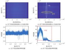
Fig.6
Interference characterization in image domain"
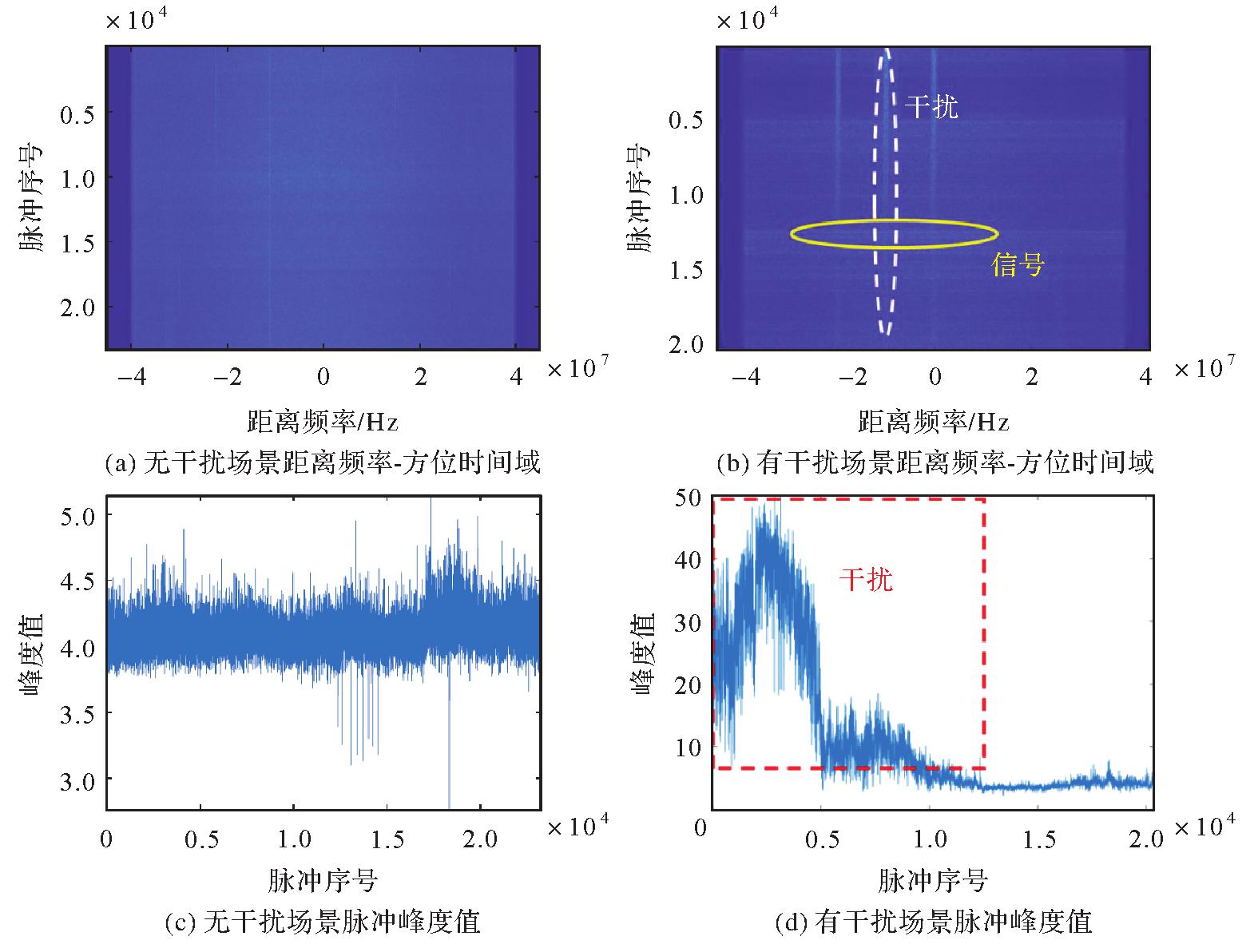
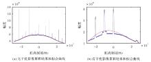
Fig.7
Illustration of interference classification results in image domain"
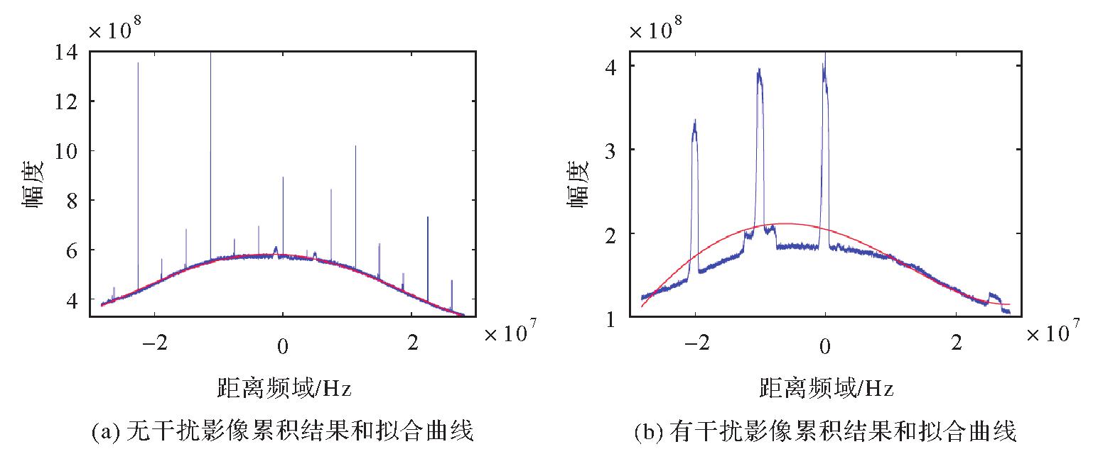
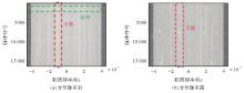
Fig.8
Comparison of range-frequency azimuth-time representation before and after azimuth compression"
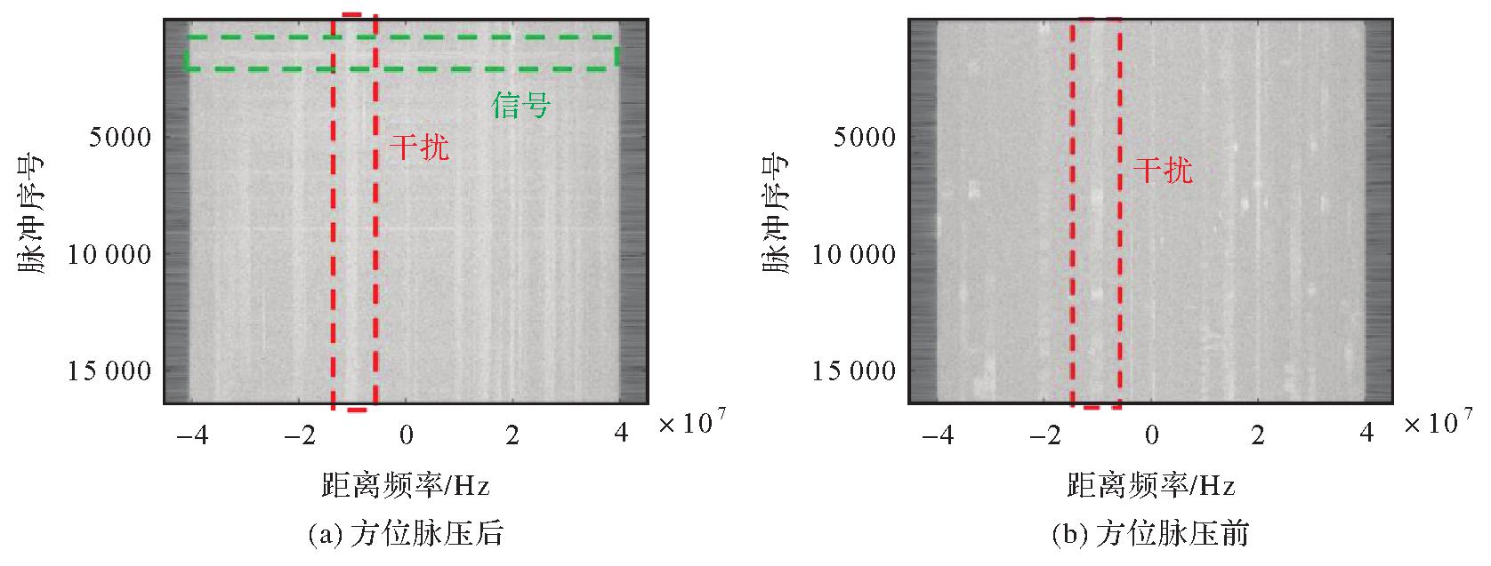

Fig.9
Statistical distribution characteristics of range-frequency-azimuth-time domain samples"
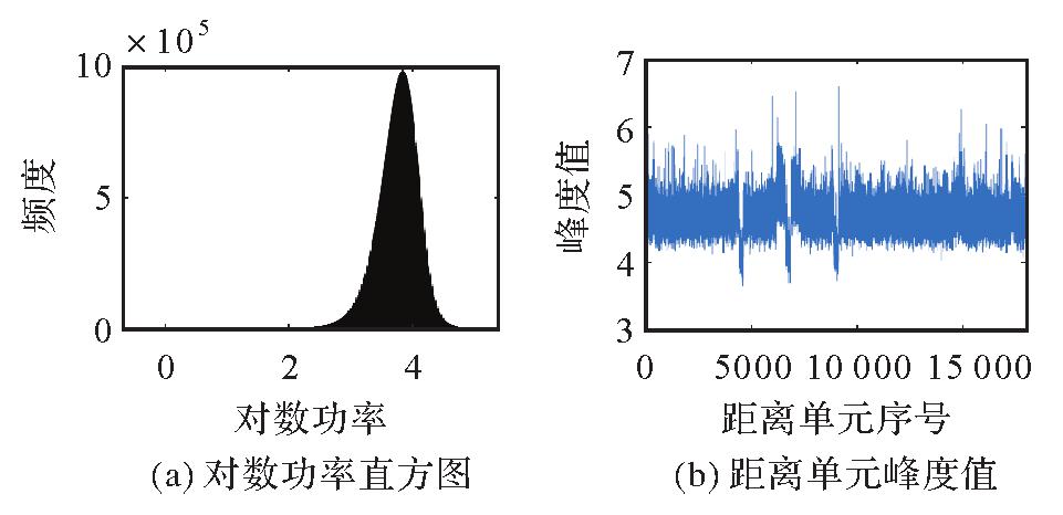
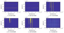
Fig.10
Experimental results after interference detection and mitigation"
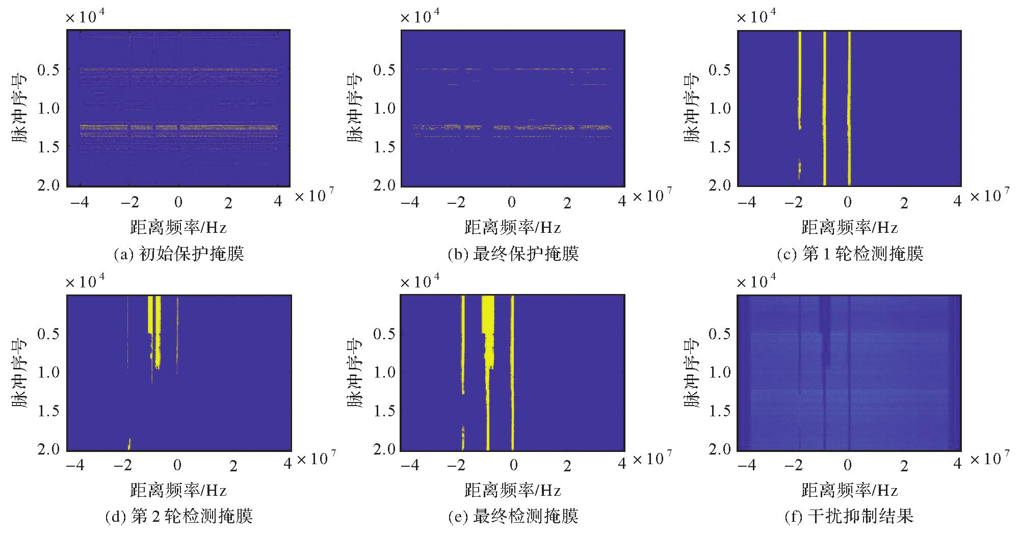
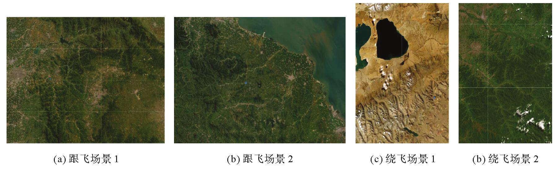
Fig.11
Geographic location of the investigation area"
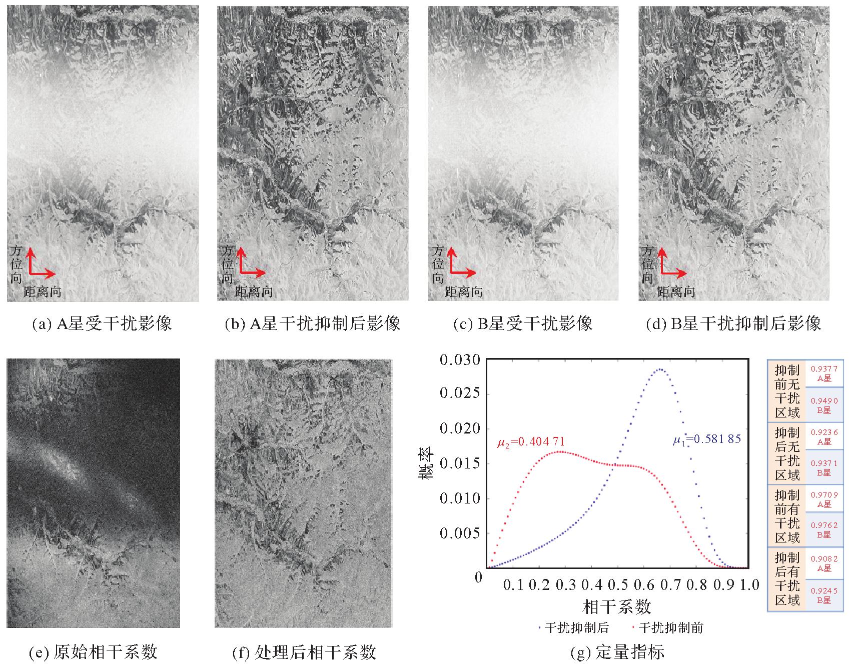
Tab.2
Performance evaluation for difference scenes"
| 干扰参数与指标 | 跟飞场景1 | 跟飞场景2 | 绕飞场景1 | 绕飞场景2 |
|---|---|---|---|---|
| 成像模式 | STRIP2 | STRIP2 | STRIP1 | STRIP1 |
| 信号带宽/MHz | 60 | 80 | 80 | 80 |
| 最大干扰带宽/MHz | 2.23 | 2.09 | 2.51 | 2.60 |
| 平均干扰带宽/MHz | 0.63 | 0.78 | 1.33 | 0.87 |
| 方位脉冲数 | 29 500 | 27 010 | 64 179 | 33 474 |
| 存在干扰脉冲数 | 17 405 | 25 332 | 28 802 | 33 474 |
| 决定系数 | 0.864 9 | 0.918 7 | 0.532 9 | 0.270 4 |
| 抑制前平均相干系数 | 0.458 4 | 0.373 6 | 0.443 0 | 0.404 7 |
| 抑制后平均相干系数 | 0.479 3 | 0.380 2 | 0.538 3 | 0.581 9 |
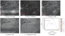
Fig.12
Experimental results of twin satellites in constellation for scene 1"
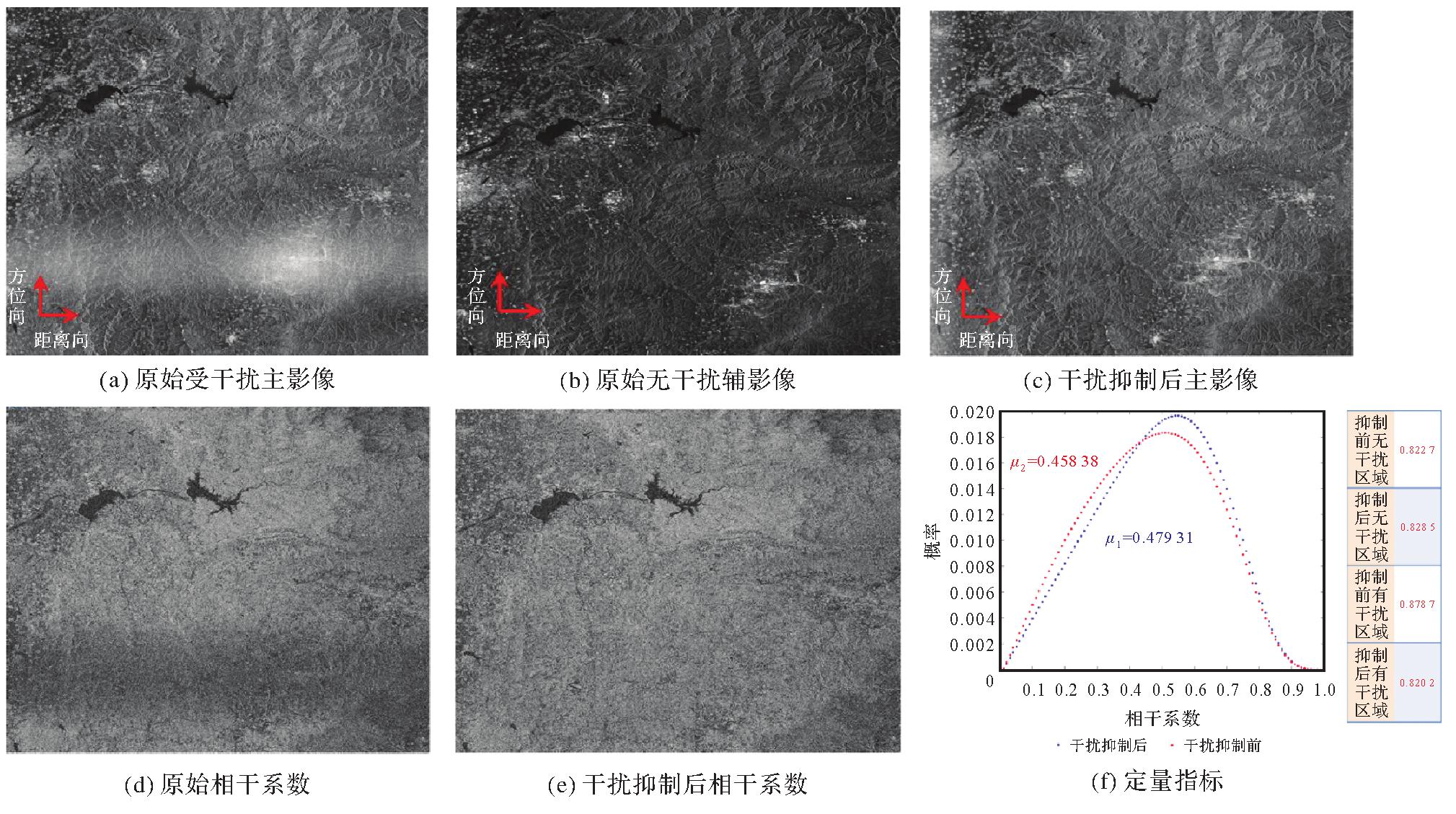
Fig.13
Experimental results of twin satellites in constellation for scene 2"
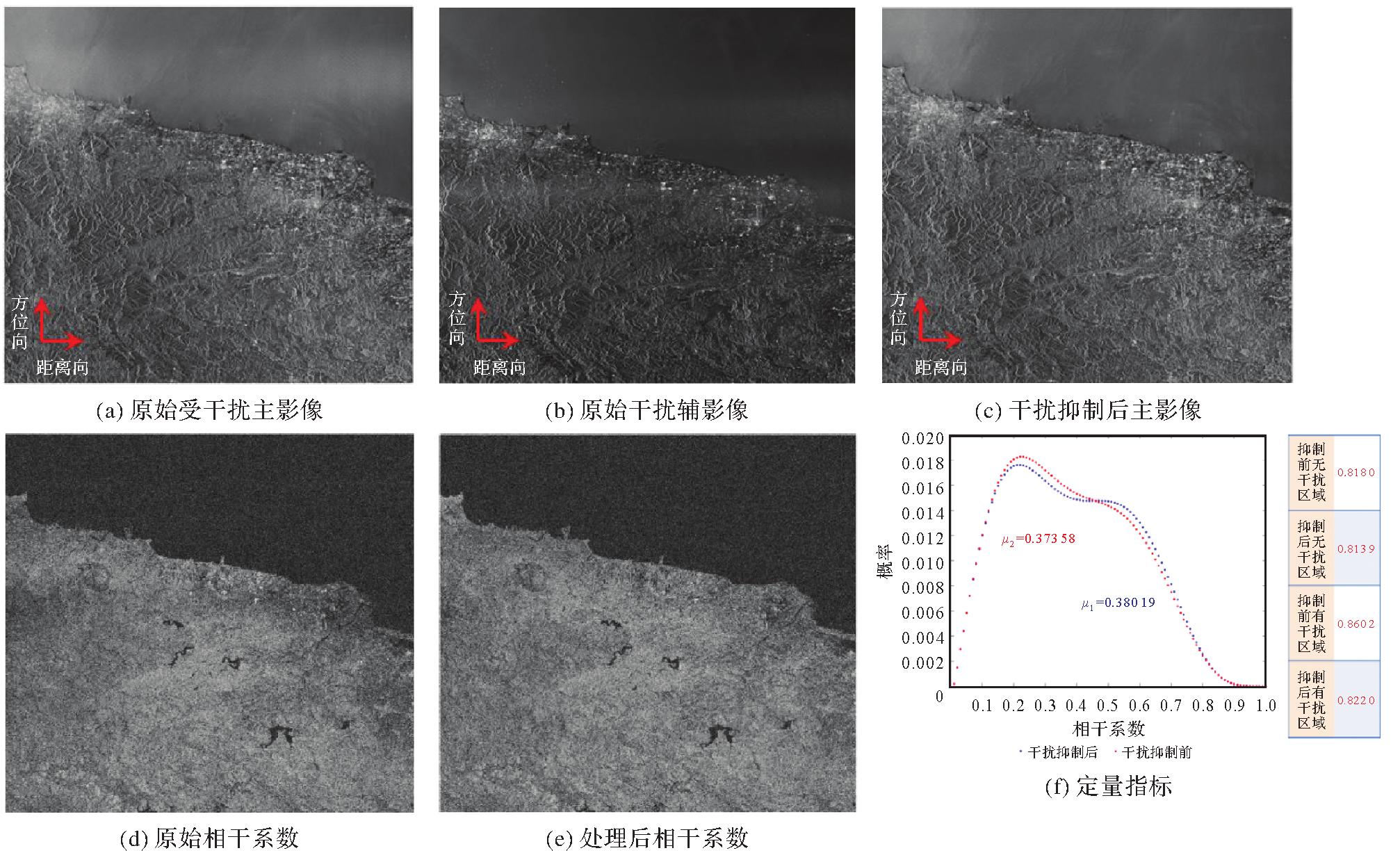
Fig.14
Experiment results of twin satellites in formation for scene 1"
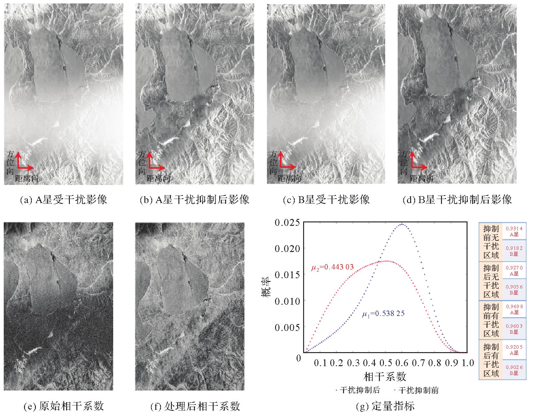

Fig.15
Experiment results of twin satellites in formation for scene 2"
| [1] |
李涛, 唐新明, 高小明, 等. SAR卫星业务化地形测绘能力分析与展望[J]. 测绘学报, 2021, 50(7):891-904. DOI:.
doi: 10.11947/j.AGCS.2021.20200199 |
|
LI Tao, TANG Xinming, GAO Xiaoming, et al. Analysis and outlook of the operational topographic surveying and mapping capability of the SAR satellites[J]. Acta Geodaetica et Cartographica Sinica, 2021, 50(7):891-904. DOI:.
doi: 10.11947/j.AGCS.2021.20200199 |
|
| [2] | LIN Haoyu, DENG Yunkai, ZHANG Heng, et al. On the processing of dual-channel receiving signals of the LuTan-1 SAR system[J]. Remote Sensing, 2022, 14(3):515. |
| [3] |
李涛, 唐新明, 李世金, 等. L波段差分干涉SAR卫星基础形变产品分类[J]. 测绘学报, 2023, 52(5):769-779. DOI:.
doi: 10.11947/j.AGCS.2023.20220050 |
|
LI Tao, TANG Xinming, LI Shijin, et al. Classification of basic deformation products of L-band differential interfero-metric SAR satellite[J]. Acta Geodaetica et Cartographica Sinica, 2023, 52(5):769-779. DOI:.
doi: 10.11947/j.AGCS.2023.20220050 |
|
| [4] | XU Bing, LIU Liqun, LI Zhiwei, et al. Design bistatic interferometric DEM generation algorithm and its theoretical accuracy analysis for LuTan-1 satellites[J]. Journal of Geodesy and Geoinformation Science, 2022, 5(1):25-38. |
| [5] | 信息产业部无线电管理局. 中华人民共和国无线电频率划分规定[M]. 北京: 人民邮电出版社, 2018. |
| Radio Regulatory Administration of the Ministry of Information and Technology. Regulations on Radio Frequency Allocation of the People's Republic of China[M]. Beijing: People's Posts and Telecommunications Press, 2018. | |
| [6] | LU Xingyu, WANG Chenchen, XU Xiaofeng, et al. Automatic RFI identification for sentinel-1 based on siamese-type deep CNN using repeat-pass images[J]. IEEE Transactions on Geoscience and Remote Sensing, 2022, 60:5231616. |
| [7] | TAO Mingliang, ZHOU Feng, LIU Jianqiang, et al. Narrow-band interference mitigation for SAR using independent subspace analysis[J]. IEEE Transactions on Geoscience and Remote Sensing, 2014, 52(9):5289-5301. |
| [8] | MONTI-GUARNIERI A, ALBINET C, COTRUFO A, et al. Passive sensing by Sentinel-1 SAR: methods and applications[J]. Remote Sensing of Environment, 2022, 270:112866. |
| [9] | LENG Xiangguang, JI Kefeng, ZHOU Shilin, et al. Discriminating ship from radio frequency interference based on noncircularity and non-Gaussianity in Sentinel-1 SAR imagery[J]. IEEE Transactions on Geoscience and Remote Sensing, 2019, 57(1):352-363. |
| [10] | CHOJKA A, ARTIEMJEW P, RAPISKI J. RFI artefacts detection in Sentinel-1 level-1 SLC data based on image processing techniques[J]. Sensors (Basel, Switzerland), 2020, 20(10):2919. |
| [11] | TAO Mingliang, LI Jieshuang, CHEN Junli, et al. Radio frequency interference signature detection in radar remote sensing image using semantic cognition enhancement network[J]. IEEE Transactions on Geoscience and Remote Sensing, 2022, 60:5231714. |
| [12] | TAO Mingliang, SU Jia, HUANG Yan, et al. Mitigation of radio frequency interference in synthetic aperture radar data: current status and future trends[J]. Remote Sensing, 2019, 11(20):2438. |
| [13] | CHEN Bingxu, LV Zongsen, LU Pingping, et al. Extension and evaluation of SSC for removing wideband RFI in SLC SAR images[J]. Remote Sensing, 2022, 14(17):4294. |
| [14] | NATSUAKI R, MOTOHKA T, WATANABE M, et al. An autocorrelation-based radio frequency interference detection and removal method in azimuth-frequency domain for SAR image[J]. IEEE Journal of Selected Topics in Applied Earth Observations and Remote Sensing, 2017, 10(12):5736-5751. |
| [15] | YANG Huizhang, TAO Mingliang, CHEN Shengyao, et al. On the mutual interference between spaceborne SARs: modeling, characterization, and mitigation[J]. IEEE Transactions on Geoscience and Remote Sensing, 2021, 59(10):8470-8485. |
| [16] | HUANG Yan, LIAO Guisheng, LI Jie, et al. Narrowband RFI suppression for SAR system via fast implementation of joint sparsity and low-rank property[J]. IEEE Transactions on Geoscience and Remote Sensing, 2018, 56(5):2748-2761. |
| [17] | TAO Mingliang, LAI Siqi, LI Jieshuang, et al. Extraction and mitigation of radio frequency interference artifacts based on time-series Sentinel-1 SAR data[J]. IEEE Transactions on Geoscience and Remote Sensing, 2022, 60:5217211. |
| [18] | JOHNSON J T, BALL C, CHEN C C, et al. Real-time detection and filtering of radio frequency interference onboard a spaceborne microwave radiometer: the CubeRRT mission[J]. IEEE Journal of Selected Topics in Applied Earth Observations and Remote Sensing, 2020, 13:1610-1624. |
| [19] | MEYER F J, NICOLL J B, DOULGERIS A P. Correction and characterization of radio frequency interference signatures in L-band synthetic aperture radar data[J]. IEEE Transactions on Geoscience and Remote Sensing, 2013, 51(10):4961-4972. |
| [20] | SCAGLIOLA M, GIUDICI D, RAMONGASSIÉ S, et al. Ground processing RFI mitigation strategy for BIOMASS: a feasibility study[C]//Proceedings of 2015 IEEE International Geoscience and Remote Sensing Symposium. Milan: IEEE, 2015: 128-131. |
| [21] | TAO Mingliang, ZHOU Feng, ZHANG Zijing. Wideband interference mitigation in high-resolution airborne synthetic aperture radar data[J]. IEEE Transactions on Geoscience and Remote Sensing, 2016, 54(1):74-87. |
| [1] | Hongmei WANG, Lihua WANG, Benhua TAN, Xiaoyi JIANG, Lili SONG, Weiwei SUN. SAR high-precision inversion of sea surface current over offshore China [J]. Acta Geodaetica et Cartographica Sinica, 2026, 55(4): 588-603. |
| [2] | Jingxuan LIU, Xuexi LIU, Kefei ZHANG, Chao YANG, Suqin WU, Shouqing ZHU, Fudong GUO. A prediction method for LOD based on combined LSTM and WLS [J]. Acta Geodaetica et Cartographica Sinica, 2026, 55(3): 477-489. |
| [3] | Zhong LU, Jinqi ZHAO, Yufen NIU, Liquan CHEN, Qianyou FAN, Jinzhao SI, Zixuan WANG, Yuan GAO, Shuai WANG, Feifei QU, Hongtao SHI, Shiyong YAN, Yun SHI, Zheng ZHAO. The NISAR mission: innovations in earth observation and applications in surface deformation monitoring [J]. Acta Geodaetica et Cartographica Sinica, 2026, 55(2): 261-274. |
| [4] | Bin HAN, Xin HUANG, Fengyi LI, Xiaozhen LU. Water body segmentation network for SAR images combining dual-encoder and adaptive feature fuse [J]. Acta Geodaetica et Cartographica Sinica, 2026, 55(1): 101-113. |
| [5] | Peng LI, Jianbo BAI, Zhenhong LI, Houjie WANG. Wide area coastal subsidence monitoring and driver analysis with multi tracks of TS-InSAR—a case study of Shandong province [J]. Acta Geodaetica et Cartographica Sinica, 2025, 54(7): 1178-1191. |
| [6] | Kefu WU, Haiqiang FU, Jianjun ZHU, Qijin HAN, Aichun WANG, Mingxia ZHANG, Zhiwei LI. LT-1 InSAR block adjustment considering the impact of penetration depth in forest areas [J]. Acta Geodaetica et Cartographica Sinica, 2025, 54(6): 1009-1020. |
| [7] | Qingli LUO, Xueyan LI, Guoman HUANG, Honghui CHEN, Minglong XUE, Jian LI. AOSN: alpha optimal structure network for height estimation from a single SAR image in mountain areas [J]. Acta Geodaetica et Cartographica Sinica, 2025, 54(5): 888-898. |
| [8] | Guangao XING, Guanming LU, Bin HAN. MAFUNet: water body segmentation algorithm for SAR images combining attention mechanisms and active contour loss [J]. Acta Geodaetica et Cartographica Sinica, 2025, 54(5): 924-936. |
| [9] | Zhaofeng DU, Guopeng LI, Zhanke LIU, Xiaming SHANG, Shengjun KANG, Xiaoqiang WANG. Comprehensive analysis of multiple monitoring methods in main subsidence areas [J]. Acta Geodaetica et Cartographica Sinica, 2025, 54(3): 481-492. |
| [10] | Ziqing WEI. Talk about X-ray pulsar navigation [J]. Acta Geodaetica et Cartographica Sinica, 2025, 54(2): 207-212. |
| [11] | Hongkai SHI, Xiufeng HE, Yihao WU, Xiangtian ZHENG, Minfeng SONG. Waveform contamination identification and accurate sea surface height extraction algorithm for high-frequency fully-focused SAR in severely interfered coastal regions [J]. Acta Geodaetica et Cartographica Sinica, 2025, 54(2): 272-285. |
| [12] | Wei PENG, Jing YANG, Haiqiang FU, Jianjun ZHU, Dong ZENG. UAV-borne repeat-pass InSAR data processing method considering motion error characteristics [J]. Acta Geodaetica et Cartographica Sinica, 2025, 54(11): 1954-1967. |
| [13] | Hailu CHEN, Yunzhong SHEN. GNSS-assisted InSAR tropospheric delay correction model incorporating vertical stratification and turbulent components [J]. Acta Geodaetica et Cartographica Sinica, 2025, 54(10): 1786-1797. |
| [14] | Yibo XING, Bin HAN, Bingkun BAO. River SAR image segmentation using L1 norm based hybrid active contours [J]. Acta Geodaetica et Cartographica Sinica, 2024, 53(8): 1598-1609. |
| [15] | Jichong YIN, Fang WU, Renjian ZHAI, Yue QIU, Xianyong GONG, Ruixing XING. Two-stream boundary constraints and relativistic generation adversarial network for building contour regularization [J]. Acta Geodaetica et Cartographica Sinica, 2024, 53(7): 1444-1457. |
| Viewed | ||||||
|
Full text |
|
|||||
|
Abstract |
|
|||||