

Acta Geodaetica et Cartographica Sinica ›› 2026, Vol. 55 ›› Issue (2): 328-343.doi: 10.11947/j.AGCS.2026.20250331
• Photogrammetry and Remote Sensing • Previous Articles Next Articles
Daifeng PENG1,2( ), Xuelian LIU1, Mengfei LU1, Haiyan GUAN1
Received:2025-09-04
Revised:2026-01-16
Online:2026-03-13
Published:2026-03-13
About author:PENG Daifeng (1988—), male, PhD, associate professor, majors in remote sensing image intelligent interpretation. E-mail: daifeng@nuist.edu.cn
Supported by:CLC Number:
Daifeng PENG, Xuelian LIU, Mengfei LU, Haiyan GUAN. Heterogeneous remote sensing image flood change detection based on multi-scale cross-modal feature fusion[J]. Acta Geodaetica et Cartographica Sinica, 2026, 55(2): 328-343.
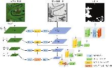
Fig. 1
The main framework of MHCDNet"
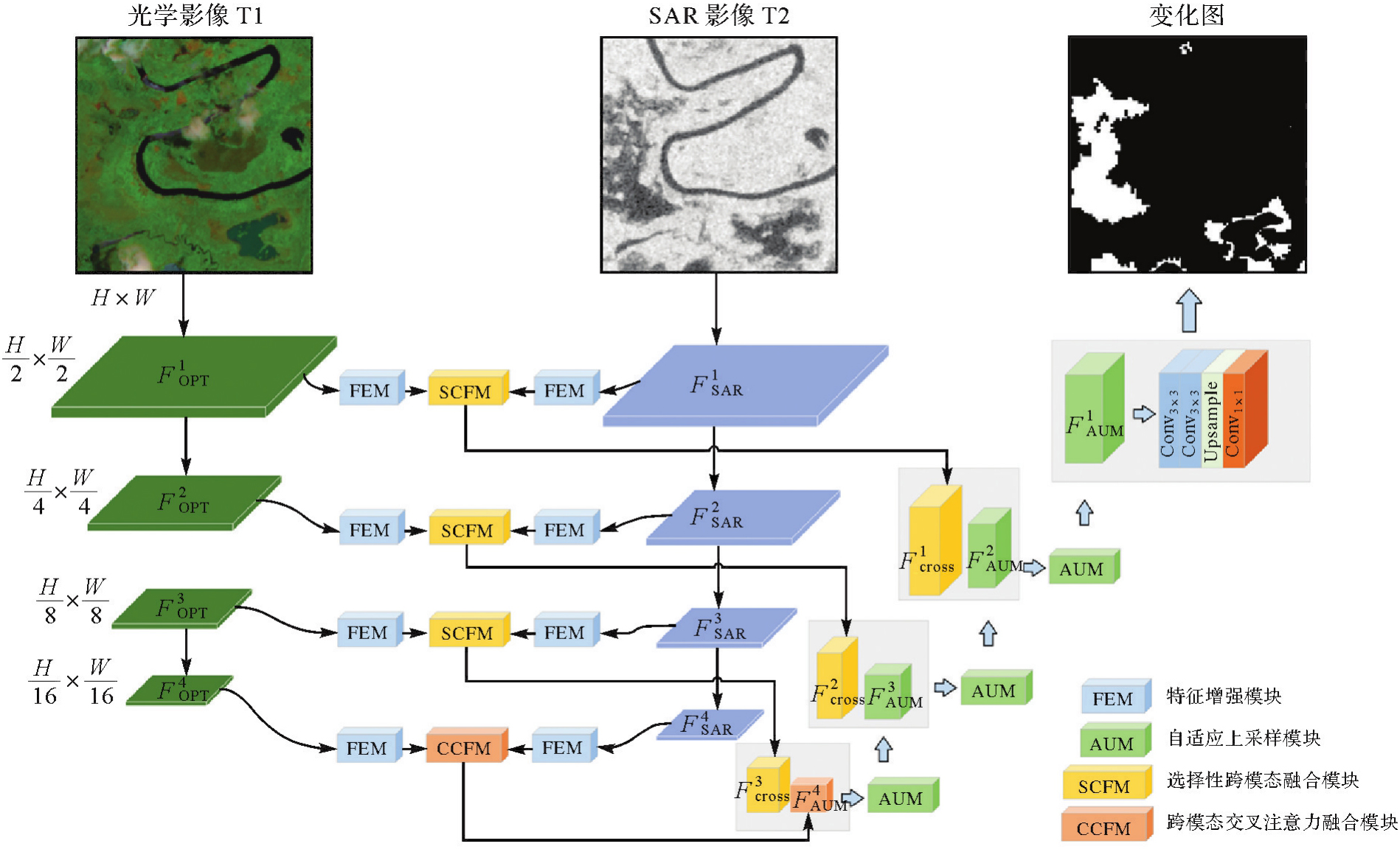
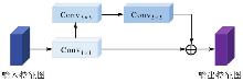
Fig. 2
FEM structure"
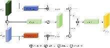
Fig. 3
SCFM structure"
Fig. 4
CCFM structure"
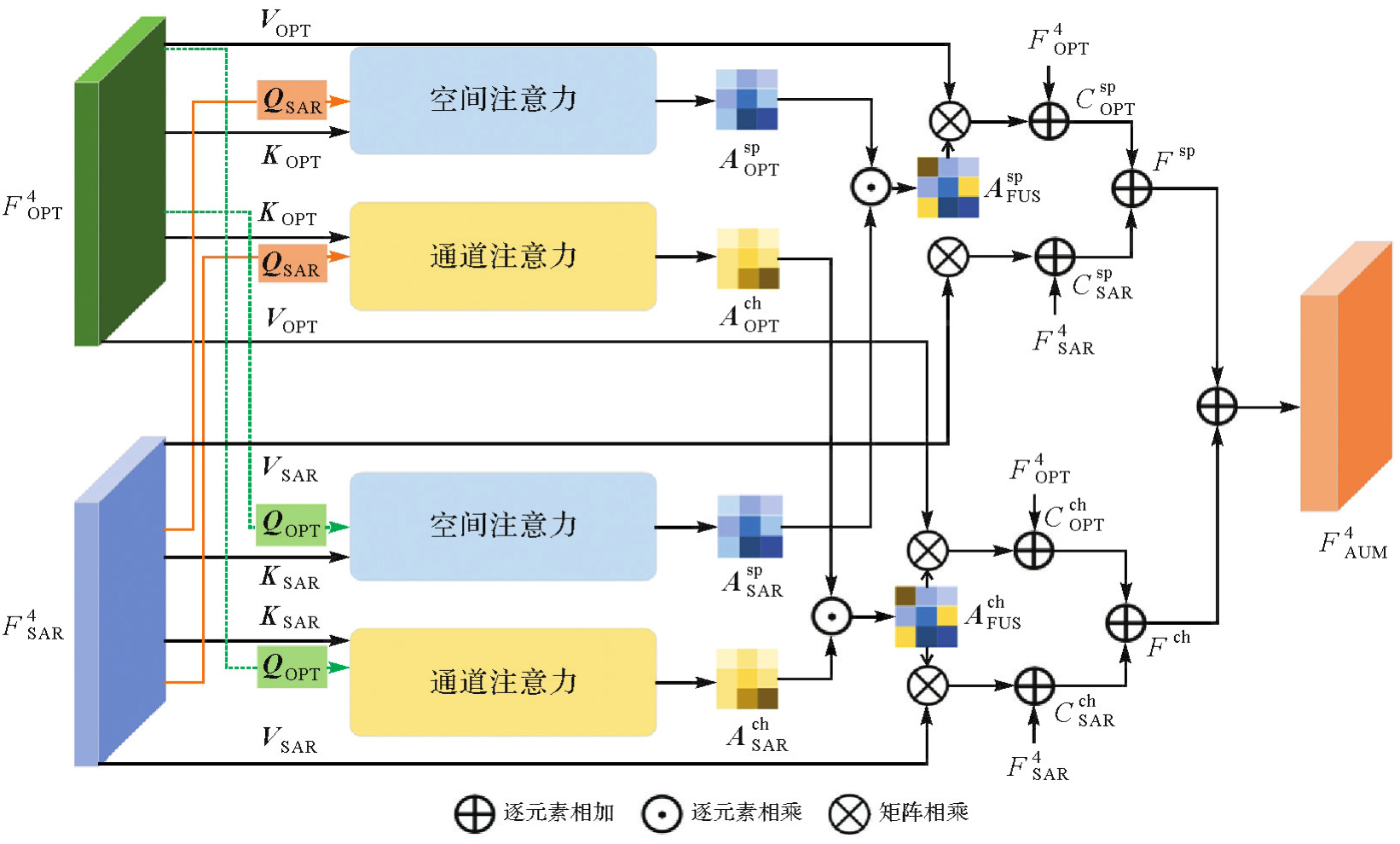
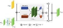
Fig. 5
The structure of AUM"
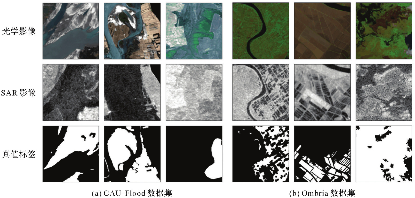
Fig. 6
Example images of different change detection datasets"
Tab. 1
Parameters of different change detection datasets"
| 数据集 | 变化类型 | 总数量 | 训练集 | 验证集 | 测试集 | 光学来源 | 光学影像通道数 | SAR来源 | SAR通道数 |
|---|---|---|---|---|---|---|---|---|---|
| CAU-Flood | 洪水 | 18 302 | 12 811 | 1830 | 3661 | Sentinel-2 | 4 | Sentinel-1 | 1 |
| Ombria | 洪水 | 844 | 590 | 84 | 170 | Sentinel-2 | 3 | Sentinel-1 | 1 |
Tab. 2
The influence of different loss function hyper-parameters settings on the change detection results"
| α | β | CAU-Flood | Ombria | ||||||||||
|---|---|---|---|---|---|---|---|---|---|---|---|---|---|
| OA | P | R | F1值 | IoU | Kappa系数 | OA | P | R | F1值 | IoU | Kappa系数 | ||
| 1 | 0 | 98.77 | 91.98 | 90.60 | 91.28 | 83.97 | 90.60 | 88.84 | 80.27 | 83.15 | 81.68 | 69.04 | 73.62 |
| 0 | 1 | 98.77 | 92.40 | 90.11 | 91.24 | 83.90 | 90.57 | 89.12 | 80.78 | 83.50 | 82.12 | 69.66 | 74.30 |
| 0.5 | 0.5 | 98.78 | 91.70 | 91.13 | 91.41 | 84.19 | 90.76 | 88.71 | 80.23 | 82.63 | 81.42 | 68.66 | 73.24 |
| 0.5 | 1 | 98.78 | 92.30 | 90.38 | 91.33 | 84.05 | 90.66 | 89.24 | 82.07 | 81.95 | 82.04 | 69.51 | 74.31 |
| 1 | 0.5 | 98.77 | 91.61 | 91.00 | 91.30 | 84.00 | 90.58 | 88.77 | 79.20 | 84.73 | 81.87 | 69.31 | 73.72 |
Tab. 3
Quantitative comparisons of different change detection methods"
| 类型 | 模型 | CAU-Flood | Ombria | ||||||||||
|---|---|---|---|---|---|---|---|---|---|---|---|---|---|
| OA | P | R | F1值 | IoU | Kappa系数 | OA | P | R | F1值 | IoU | Kappa系数 | ||
| 单模态 | BIT | 97.33 | 92.00 | 68.43 | 78.48 | 64.59 | 77.10 | 83.29 | 70.29 | 76.46 | 73.25 | 57.79 | 61.13 |
| DMINet | 97.47 | 93.54 | 69.14 | 79.51 | 65.99 | 78.19 | 85.47 | 76.05 | 75.06 | 75.55 | 60.71 | 65.22 | |
| 多模态 | CMCDNet | 98.51 | 90.78 | 90.00 | 90.39 | 80.73 | 88.54 | 87.96 | 78.33 | 82.65 | 80.43 | 67.27 | 71.75 |
| FTransUNet | 98.31 | 90.83 | 87.90 | 89.34 | 78.78 | 87.23 | 87.68 | 79.87 | 78.66 | 79.26 | 65.65 | 70.51 | |
| CMFNet | 98.64 | 88.22 | 88.04 | 88.13 | 82.47 | 89.66 | 87.47 | 77.30 | 82.29 | 79.72 | 66.28 | 70.67 | |
| SD-Mamba | 98.00 | 88.98 | 82.04 | 85.37 | 74.47 | 84.30 | 84.82 | 71.27 | 80.32 | 75.52 | 60.67 | 64.16 | |
| MHCDNet | 98.78 | 91.70 | 91.13 | 91.41 | 84.19 | 90.76 | 89.12 | 80.78 | 83.50 | 82.12 | 69.66 | 74.30 | |
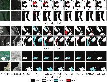
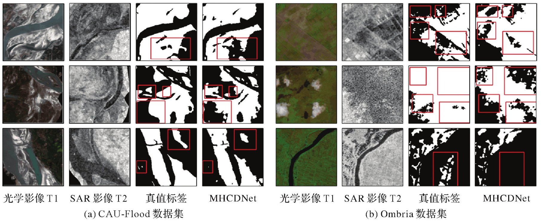
Fig. 7
Change detection results of different methods on CAU-Flood dataset"
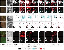
Fig. 8
Change detection results of different methods on Ombria dataset"
Tab. 4
Comparison of accuracy and complexity of different models on CAU-Flood dataset"
| 方法 | 是否多模态模型 | F1值/(%) | 参数量/M | FLOPs/G |
|---|---|---|---|---|
| BIT | × | 78.48 | 3.49 | 10.60 |
| DMINet | × | 79.51 | 6.24 | 14.55 |
| CMCDNet | √ | 90.39 | 198.74 | 30.41 |
| FTransUNet | √ | 89.34 | 160.88 | 45.21 |
| CMFNet | √ | 88.13 | 78.25 | 123.63 |
| SD-Mamba | √ | 85.37 | 5.34 | 10.19 |
| MHCDNet | √ | 91.41 | 20.94 | 20.11 |
Tab. 5
The influence of different experimental settings on the change detection results"
| FEM | AUM | SCFM | CCFM | CAU-Flood | Ombria | ||||||||||
|---|---|---|---|---|---|---|---|---|---|---|---|---|---|---|---|
| OA | P | R | F1值 | IoU | Kappa系数 | OA | P | R | F1值 | IoU | Kappa系数 | ||||
| × | × | × | × | 98.63 | 90.89 | 89.75 | 90.32 | 82.35 | 89.59 | 87.07 | 76.86 | 81.23 | 78.99 | 65.27 | 69.66 |
| √ | × | × | × | 98.70 | 90.96 | 90.77 | 90.86 | 83.26 | 90.17 | 87.88 | 79.19 | 80.72 | 79.94 | 66.59 | 71.27 |
| √ | √ | × | × | 98.72 | 91.63 | 90.25 | 90.93 | 83.38 | 90.25 | 88.54 | 80.34 | 81.68 | 81.00 | 68.08 | 72.80 |
| √ | √ | √ | × | 98.76 | 92.04 | 90.37 | 91.20 | 83.82 | 90.54 | 88.92 | 81.51 | 81.44 | 81.48 | 68.75 | 73.58 |
| √ | √ | √ | √ | 98.78 | 91.70 | 91.13 | 91.41 | 84.19 | 90.76 | 89.12 | 80.07 | 83.50 | 82.12 | 69.66 | 74.30 |
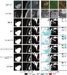
Fig. 9
Visual results of ablation studies"
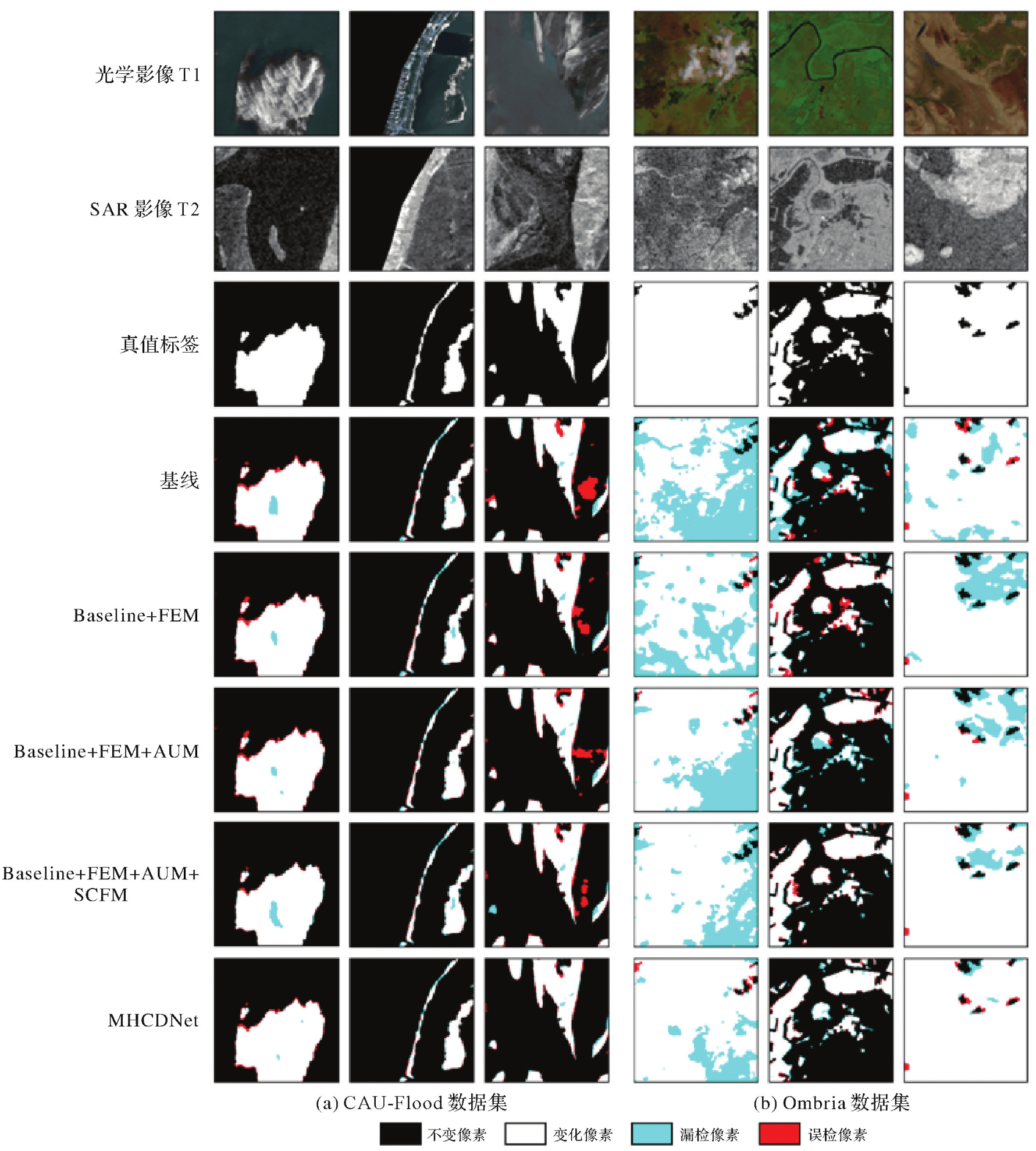
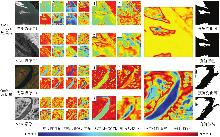
Fig. 10
Visualization results of different feature maps"
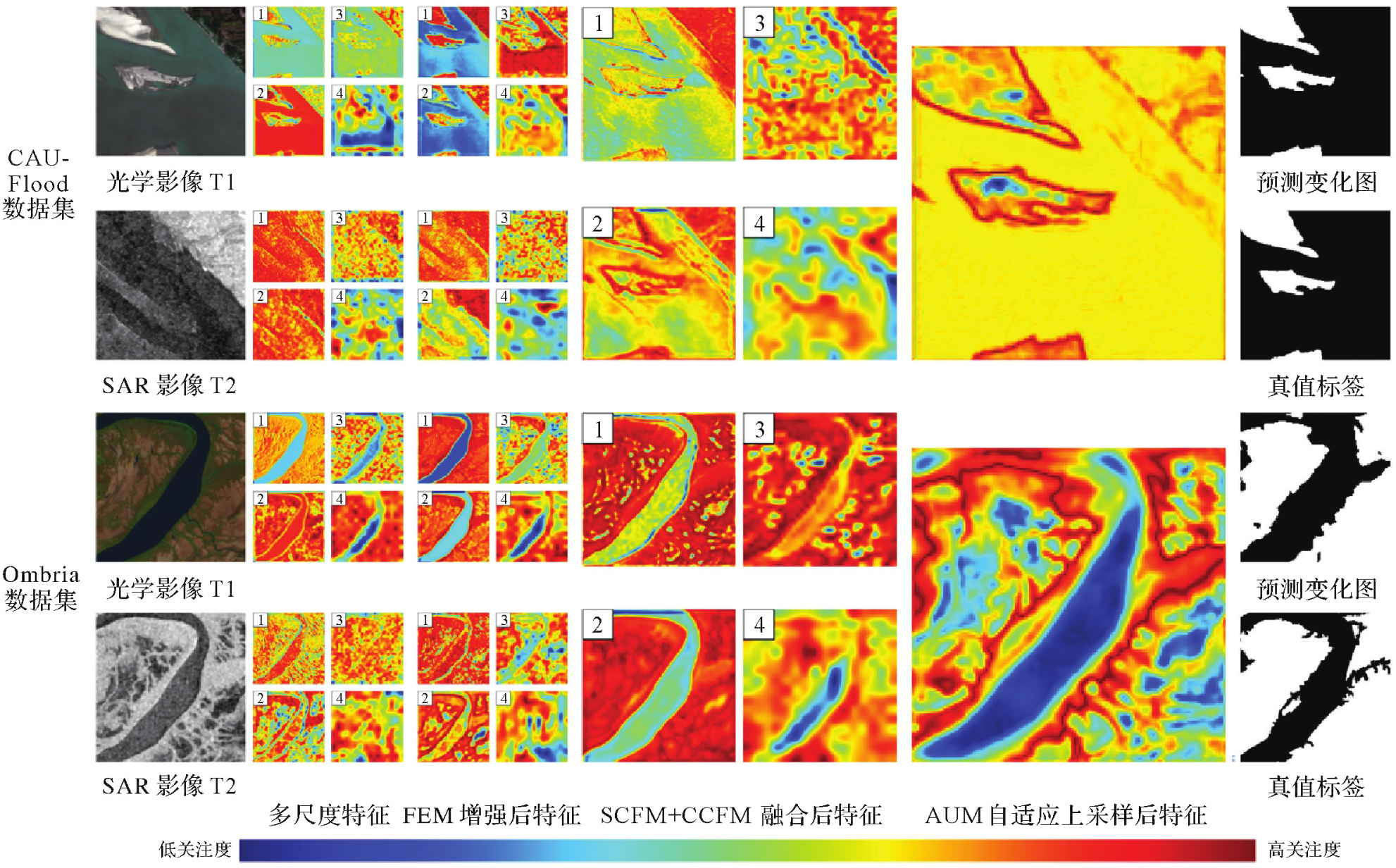
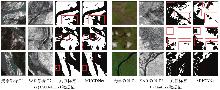
Fig. 11
Visual results of failure cases in different datasets"
| [1] | BRUZZONE L, BOVOLO F. A novel framework for the design of change-detection systems for very-high-resolution remote sensing images[J]. Proceedings of the IEEE, 2013, 101(3): 609-630. |
| [2] | PATEL A, VYAS D, CHAUDHARI N, et al. Novel approach for the LULC change detection using GIS & Google Earth Engine through spatiotemporal analysis to evaluate the urbanization growth of Ahmedabad city[J]. Results in Engineering, 2024, 21: 101788. |
| [3] | QING Yuanzhao, MING Dongping, WEN Qi, et al. Operational earthquake-induced building damage assessment using CNN-based direct remote sensing change detection on superpixel level[J]. International Journal of Applied Earth Observation Geoinformation, 2022, 112: 102899. |
| [4] | WANG Nan, LI Wei, TAO Ran, et al. Graph-based block-level urban change detection using Sentinel-2 time series[J]. Remote Sensing of Environment, 2022, 274: 112993. |
| [5] | 陈立福, 金昱忱, 李振洪, 等. 基于多特征交叉融合孪生网络的SAR影像地震滑坡识别[J]. 武汉大学学报(信息科学版), 2025, 50(5): 917-927. |
| CHEN Lifu, JIN Yuchen, LI Zhenhong, et al. SAR image earthquake landslide recognition based on multi-featurecross-fused siamese network[J]. Geomatics and Information Science of Wuhan University, 2025, 50(5): 917-927. | |
| [6] |
赵金奇, 李宇轩, 刘子蓉, 等. 基于相似性衡量函数优化的SAR时空极化信息一体化洪涝变化检测方法[J]. 测绘学报, 2024, 53(12): 2375-2390. DOI: .
doi: 10.11947/j.AGCS.2024.20230355 |
|
ZHAO Jinqi, LI Yuxuan, LIU Zirong, et al. Flood change detection method using optimized similarity measurement function with temporal-spatial-polarized SAR information[J]. Acta Geodaetica et Cartographica Sinica, 2024, 53(12): 2375-2390. DOI: .
doi: 10.11947/j.AGCS.2024.20230355 |
|
| [7] | MERCIER G, MOSER G, SERPICO S B. Conditional copulas for change detection in heterogeneous remote sensing images[J]. IEEE Transactions on Geoscience Remote Sensing, 2008, 46(5): 1428-1441. |
| [8] | PRENDES J, CHABERT M, PASCAL F, et al. A new multivariate statistical model for change detection in images acquired by homogeneous and heterogeneous sensors[J]. IEEE Transactions on Image Processing, 2014, 24(3): 799-812. |
| [9] | TOUATI R, MIGNOTTE M, DAHMANE M. Multimodal change detection in remote sensing images using an unsupervised pixel pair-wise-based Markov random field model[J]. IEEE Transactions on Image Processing, 2019, 29: 757-767. |
| [10] | ZHOU Weiqi, TROY A, GROVE M. Object-based land cover classification and change analysis in the Baltimore metropolitan area using multitemporal high resolution remote sensing data[J]. Sensors, 2008, 8(3): 1613-1636. |
| [11] | WAN Ling, XIANG Yuming, YOU Hongjian. A post-classification comparison method for SAR and optical images change detection[J]. IEEE Geoscience Remote Sensing Letters, 2019, 16(7): 1026-1030. |
| [12] | ALBERGA V. Similarity measures of remotely sensed multi-sensor images for change detection applications[J]. Remote Sensing, 2009, 1(3): 122-143. |
| [13] | KWAN C, AYHAN B, LARKIN J, et al. Performance of change detection algorithms using heterogeneous images and extended multi-attribute profiles (EMAPs)[J]. Remote Sensing, 2019, 11(20): 2377. |
| [14] |
燕琴, 顾海燕, 杨懿, 等. 智能遥感大模型研究进展与发展方向[J]. 测绘学报, 2024, 53(10): 1967-1980. DOI: .
doi: 10.11947/j.AGCS.2024.20240053 |
|
YAN Qin, GU Haiyan, YANG Yi, et al. Research progress and trend of intelligent remote sensing large model[J]. Acta Geodaetica et Cartographica Sinica, 2024, 53(10): 1967-1980. DOI: .
doi: 10.11947/j.AGCS.2024.20240053 |
|
| [15] | LI Xinghua, DU Zhengshun, HUANG Yanyuan, et al. A deep translation (GAN) based change detection network for optical and SAR remote sensing images[J]. ISPRS Journal of Photogrammetry Remote Sensing, 2021, 179: 14-34. |
| [16] | DU Zhengshun, LI Xinghua, MIAO Jianhao, et al. Concatenated deep learning framework for multi-task change detection of optical and SAR images[J]. IEEE Journal of Selected Topics in Applied Earth Observations Remote Sensing, 2023, 17: 719-731. |
| [17] | 刘秦森, 孙帮勇. 光学信号Token引导的异源遥感变化检测网络[J]. 遥感学报, 2024, 28(1): 88-104. |
| LIU Qinsen, SUN Bangyong. Optical-signal Token guided change detection network for heterogeneous remote sensing image[J]. National Remote Sensing Bulletin, 2024, 28(1): 88-104. | |
| [18] | HAFNER S, NASCETTI A, AZIZPOUR H, et al. Sentinel-1 and Sentinel-2 data fusion for urban change detection using a dual stream U-Net[J]. IEEE Geoscience Remote Sensing Letters, 2021, 19: 1-5. |
| [19] | LI Haoyang, ZHU Fangjie, ZHENG Xiaoyu, et al. MSCDUNet: a deep learning framework for built-up area change detection integrating multispectral, SAR, and VHR data[J]. IEEE Journal of Selected Topics in Applied Earth Observations Remote Sensing, 2022, 15: 5163-5176. |
| [20] | HE Xiaoning, ZHANG Shuangcheng, XUE Bowei, et al. Cross-modal change detection flood extraction based on convolutional neural network[J]. International Journal of Applied Earth Observation Geoinformation, 2023, 117: 103197. |
| [21] | ZHANG Chenxiao, FENG Yukang, HU Lei, et al. A domain adaptation neural network for change detection with heterogeneous optical and SAR remote sensing images[J]. International Journal of Applied Earth Observation Geoinformation, 2022, 109: 102769. |
| [22] | DENG Kai, HU Xiangyun, ZHANG Zhili, et al. Cross-modal change detection using historical land use maps and current remote sensing images[J]. ISPRS Journal of Photogrammetry Remote Sensing, 2024, 218: 114-132. |
| [23] | CHENG Wei, FENG Yining, SONG Liyang, et al. DMF2Net: dynamic multi-level feature fusion network for heterogeneous remote sensing image change detection[J]. Knowledge-based Systems, 2024, 300: 112159. |
| [24] | WANG D, MA Guorui, ZHANG Haiming, et al. Refined change detection in heterogeneous low-resolution remote sensing images for disaster emergency response[J]. ISPRS Journal of Photogrammetry and Remote Sensing, 2025, 220: 139-155. |
| [25] | SHEN Yu, YAO Shuang, QIANG Zhenkai, et al. SD-Mamba: a lightweight synthetic-decompression network for cross-modal flood change detection[J]. International Journal of Applied Earth Observation and Geoinformation, 2025, 136: 104409. |
| [26] | WANG Yi, ALBRECHT C M, BRAHAM N A A, et al. Decoupling common and unique representations for multimodal self-supervised learning[C]//Proceedings of 2024 European Conference on Computer Vision. Cham: Springer International Publishing, 2024: 286-303. |
| [27] | WU Kang, ZHANG Yingying, RU Lixiang, et al. A semantic-enhanced multi-modal remote sensing foundation model for Earth observation[J]. Nature Machine Intelligence, 2025, 7: 1235-1249. |
| [28] | DRAKONAKIS G I, TSAGKATAKIS G, FOTIADOU K, et al. Ombrianet—supervised flood mapping via convolutional neural networks using multitemporal Sentinel-1 and Sentinel-2 data fusion[J]. IEEE Journal of Selected Topics in Applied Earth Observations Remote Sensing, 2022, 15: 2341-2356. |
| [29] | CHEN Hao, QI Zipeng, SHI Zhenwei. Remote sensing image change detection with transformers[J]. IEEE Transactions on Geoscience Remote Sensing, 2021, 60: 5607514. |
| [30] | FENG Yuchao, JIANG Jiawei, XU Honghui, et al. Change detection on remote sensing images using dual-branch multilevel intertemporal network[J]. IEEE Transactions on Geoscience Remote Sensing, 2023, 61: 4401015. |
| [31] | MA Xianping, ZHANG Xiaokang, PUN M O, et al. A multilevel multimodal fusion Transformer for remote sensing semantic segmentation[J]. IEEE Transactions on Geoscience Remote Sensing, 2024, 62: 5403215. |
| [32] | MA Xianping, ZHANG Xiaokang, PUN M O. A crossmodal multiscale fusion network for semantic segmentation of remote sensing data[J]. IEEE Journal of Selected Topics in Applied Earth Observations Remote Sensing, 2022, 15: 3463-3474. |
| [1] | Peng LI, Jiahan ZHANG, Zhihan WANG, Houjie WANG, Zhenhong LI. A review of intertidal topography reconstruction methods: current status, challenges and trends [J]. Acta Geodaetica et Cartographica Sinica, 2026, 55(4): 571-587. |
| [2] | bolin FU, Keyue HUANG, Yanli YANG, Weiwei SUN, Zhaoyin WANG. Multi-scene analysis of mangrove soil spectral response characteristics and inversion of soil organic carbon content based on measured full-spectrum hyperspectral data [J]. Acta Geodaetica et Cartographica Sinica, 2026, 55(4): 604-617. |
| [3] | Lanxin WU, Jiangtao PENG, Weiwei SUN, Bing YANG. An Euler embedding and complementary feature modeling framework for hyperspectral change detection in coastal wetlands [J]. Acta Geodaetica et Cartographica Sinica, 2026, 55(4): 618-631. |
| [4] | Ertao GAO, Jing LIU, Shujin LI, Guoqing ZHOU, Bolin FU, Shuxian LI. Multi-dimensional spatiotemporal monitoring and analysis of tidal flats in the Maowei Sea using integrated optical remote sensing and SAR [J]. Acta Geodaetica et Cartographica Sinica, 2026, 55(4): 632-646. |
| [5] | Hao XU, Nan XU, Huichao XIN, Yue MA, Wei TU, Qingquan LI. A topographic photon extraction method for intertidal zones using ICESat-2 satellite altimeter data [J]. Acta Geodaetica et Cartographica Sinica, 2026, 55(4): 658-672. |
| [6] | Jinwei BU, Shuhui LIU, Shunshuang XU, Tongsu XIANG, Qiulan WANG, Chaoying JI, Xiaoqing ZUO. Construction of an empirical model for estimating the global wave period of spaceborne GNSS-R [J]. Acta Geodaetica et Cartographica Sinica, 2026, 55(4): 684-697. |
| [7] | Zexin YANG. Research on key technologies for reconstructing building models with multi-LODs using point clouds [J]. Acta Geodaetica et Cartographica Sinica, 2026, 55(4): 755-755. |
| [8] | Yongxiang YAO. Generalized similarity feature-based robust matching of multi-modal remote sensing images [J]. Acta Geodaetica et Cartographica Sinica, 2026, 55(4): 757-757. |
| [9] | Dong XU. Research on key technologies of global localization using multisource geo-referenced point cloud [J]. Acta Geodaetica et Cartographica Sinica, 2026, 55(4): 760-760. |
| [10] | Chenming YE, Zhizhong KANG, Jinhao CAI, Bingzheng ZUO, Shuai SHAO, Yan LI. A morphology-guided real-scene 3D modeling method of lunar geo-entities [J]. Acta Geodaetica et Cartographica Sinica, 2026, 55(3): 525-535. |
| [11] | Meilian WANG. Machine learning based methods for tree species classification and wood-leaf separation from handheld LiDAR data [J]. Acta Geodaetica et Cartographica Sinica, 2026, 55(3): 569-569. |
| [12] | Haopeng HU, Hangbin WU, Shihao ZHAN, Zaihao WEN, Chun LIU. Road pole-like object change detection supported by visual point cloud quality optimization [J]. Acta Geodaetica et Cartographica Sinica, 2026, 55(2): 344-358. |
| [13] | Donghang YU. Research on scene and object recognition in high resolution remote sensing images [J]. Acta Geodaetica et Cartographica Sinica, 2026, 55(2): 377-377. |
| [14] | Bin HAN, Xin HUANG, Fengyi LI, Xiaozhen LU. Water body segmentation network for SAR images combining dual-encoder and adaptive feature fuse [J]. Acta Geodaetica et Cartographica Sinica, 2026, 55(1): 101-113. |
| [15] | Yu DANG, Jianjun ZHU, Haiqiang FU, Haitao ZHAO, Haipeng CHEN. Anomaly detection method for small-sample optical remote sensing constrained by diffusion characteristics [J]. Acta Geodaetica et Cartographica Sinica, 2026, 55(1): 114-123. |
| Viewed | ||||||
|
Full text |
|
|||||
|
Abstract |
|
|||||