

Acta Geodaetica et Cartographica Sinica ›› 2026, Vol. 55 ›› Issue (4): 588-603.doi: 10.11947/j.AGCS.2026.20250444
• Coastal and Marine Surveying, Mapping, and Remote Sensing • Previous Articles Next Articles
Hongmei WANG1,2( ), Lihua WANG1,2,3(), Benhua TAN4,5, Xiaoyi JIANG6, Lili SONG6, Weiwei SUN1,2,3
Received:2025-10-22
Revised:2026-03-31
Online:2026-05-11
Published:2026-05-11
Contact:
Lihua WANG
E-mail:1298140836@qq.com;wanglihua1@nbu.edu.cn
About author:WANG Hongmei (2000—), female, postgraduate, majors in microwave remote sensing. E-mail: 1298140836@qq.com
Supported by:CLC Number:
Hongmei WANG, Lihua WANG, Benhua TAN, Xiaoyi JIANG, Lili SONG, Weiwei SUN. SAR high-precision inversion of sea surface current over offshore China[J]. Acta Geodaetica et Cartographica Sinica, 2026, 55(4): 588-603.
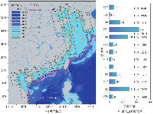
Fig. 1
Study location and statistics of image counts per orbit"
Fig. 2
Sentinel-1 SAR backscatter cross-section and radial velocity"
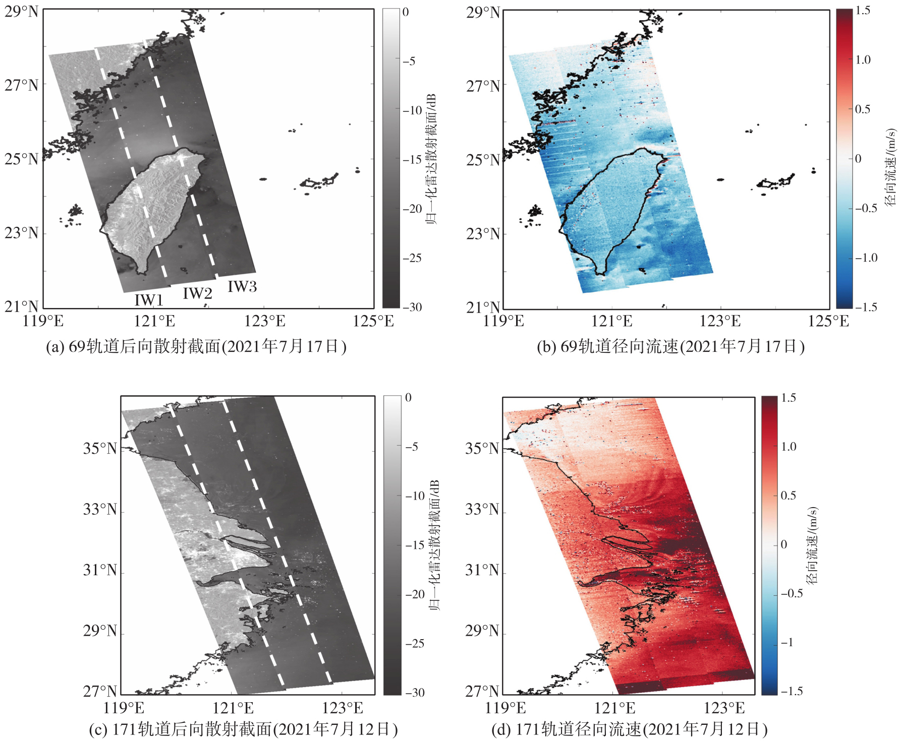
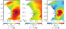
Fig. 3
Global ocean reanalysis data (taking orbit 171 on July 12, 2021 as an example)"
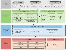
Fig. 4
Overall framework of this paper"
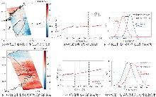
Fig. 5
Correction effect of non-geophysical terms"
Tab. 1
Statistical results of mean land radial current velocity before and after correction of non-geophysical terms"
| 69轨道影像日期 | 样本点数量 | 径向流速均值/(m/s) | |
|---|---|---|---|
| 校正前 | 校正后 | ||
| 2021-01-06 | 231 718 | -0.62 | -0.32 |
| 2021-01-18 | 231 244 | -0.65 | -0.31 |
| 2021-01-30 | 231 175 | -0.50 | -0.31 |
| 2021-02-11 | 230 698 | -0.19 | -0.43 |
| 2021-02-23 | 231 290 | -0.98 | -0.53 |
| 2021-03-07 | 231 508 | -0.39 | -0.30 |
| 2021-03-19 | 229 419 | 0.04 | -0.05 |
| 2021-03-31 | 228 082 | 0.39 | 0.00 |
| 2021-04-12 | 229 656 | 0.07 | -0.03 |
| 2021-04-24 | 231 331 | -0.42 | -0.48 |
| 2021-05-06 | 229 204 | 0.39 | -0.18 |
| 2021-05-18 | 226 262 | 0.68 | 0.18 |
| 2021-05-30 | 226 097 | 0.32 | 0.11 |
| 2021-06-11 | 228 428 | 0.32 | 0.01 |
| 2021-06-23 | 226 100 | 0.12 | -0.29 |
| 2021-07-05 | 230 067 | 0.63 | -0.24 |
| 2021-07-17 | 230 637 | -0.57 | -0.17 |
| 2021-07-29 | 229 606 | 0.60 | 0.53 |
| 2021-08-10 | 230 643 | 0.61 | 0.47 |
| 2021-08-22 | 228 044 | 0.40 | 0.33 |
| 2021-09-03 | 227 244 | 0.11 | 0.02 |
| 2021-09-27 | 228 210 | -0.29 | -0.24 |
| 2021-10-09 | 231 976 | -0.61 | -0.37 |
| 2021-10-21 | 231 940 | -0.40 | -0.22 |
| 2021-11-02 | 230 555 | -1.27 | -0.54 |
| 2021-11-14 | 216 620 | -1.30 | -0.47 |
| 2021-11-26 | 219 447 | -1.34 | -0.35 |
| 2021-12-08 | 219 385 | -1.23 | -0.36 |
| 2021-12-20 | 215 697 | -1.01 | -0.19 |
Fig. 6
Correction effect of geophysical terms"
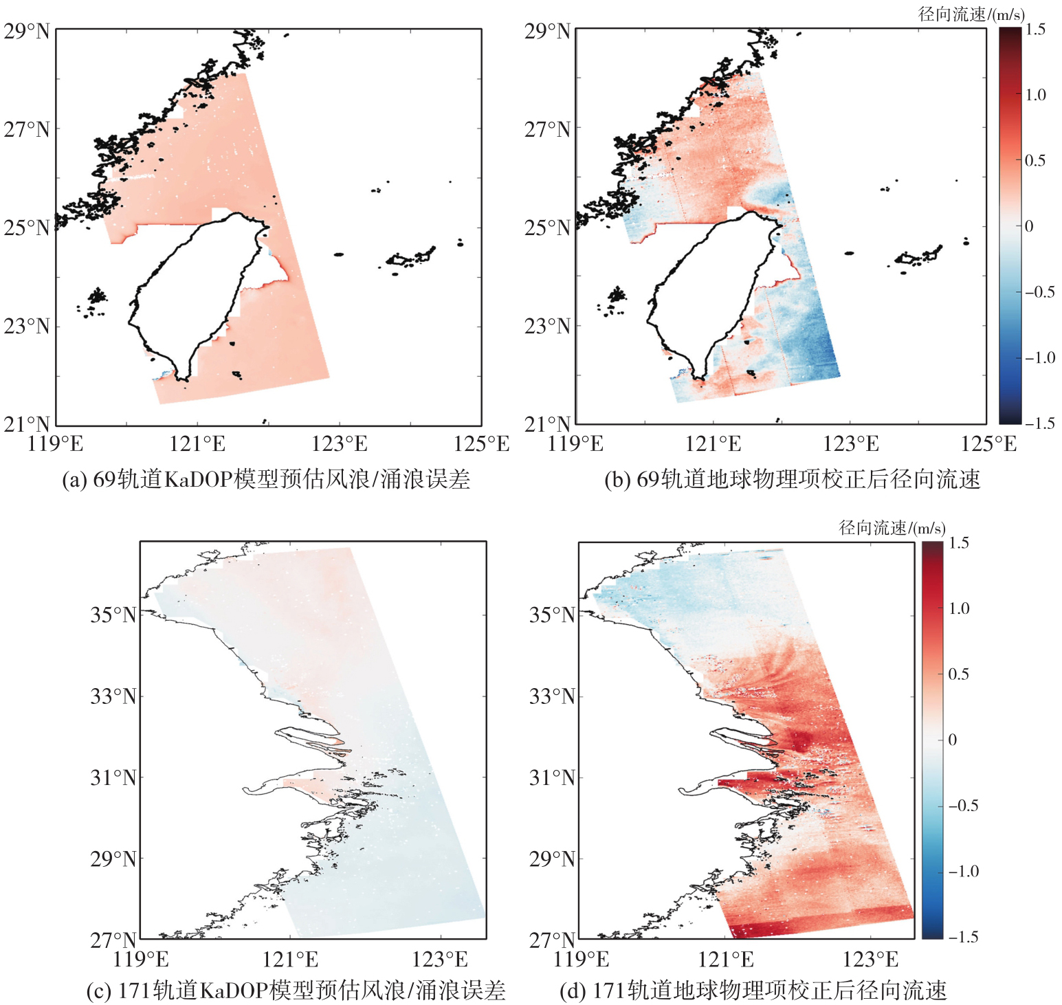
Fig. 7
SAR-derived radial current velocity results over offshore China in January, May, July, and December 2021"
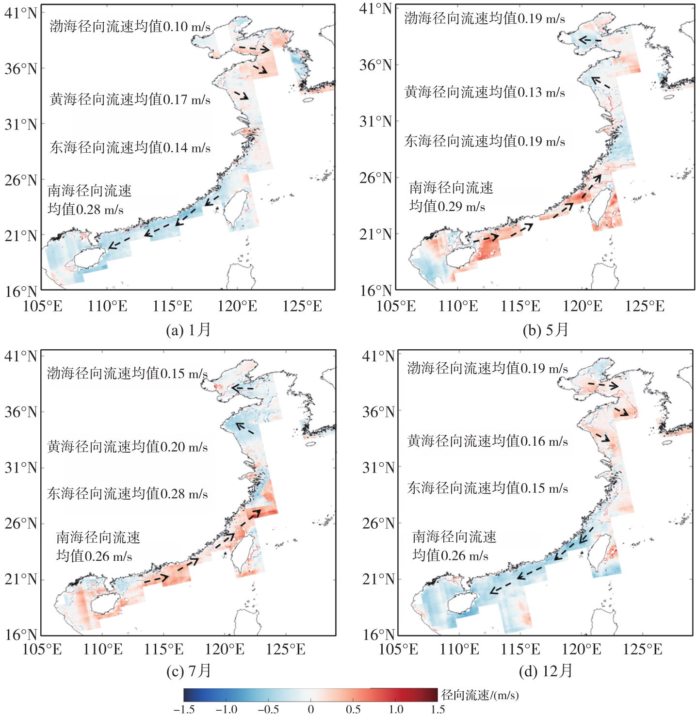
Fig. 8
Statistical results of radial current velocity over offshore China from January to December 2021"
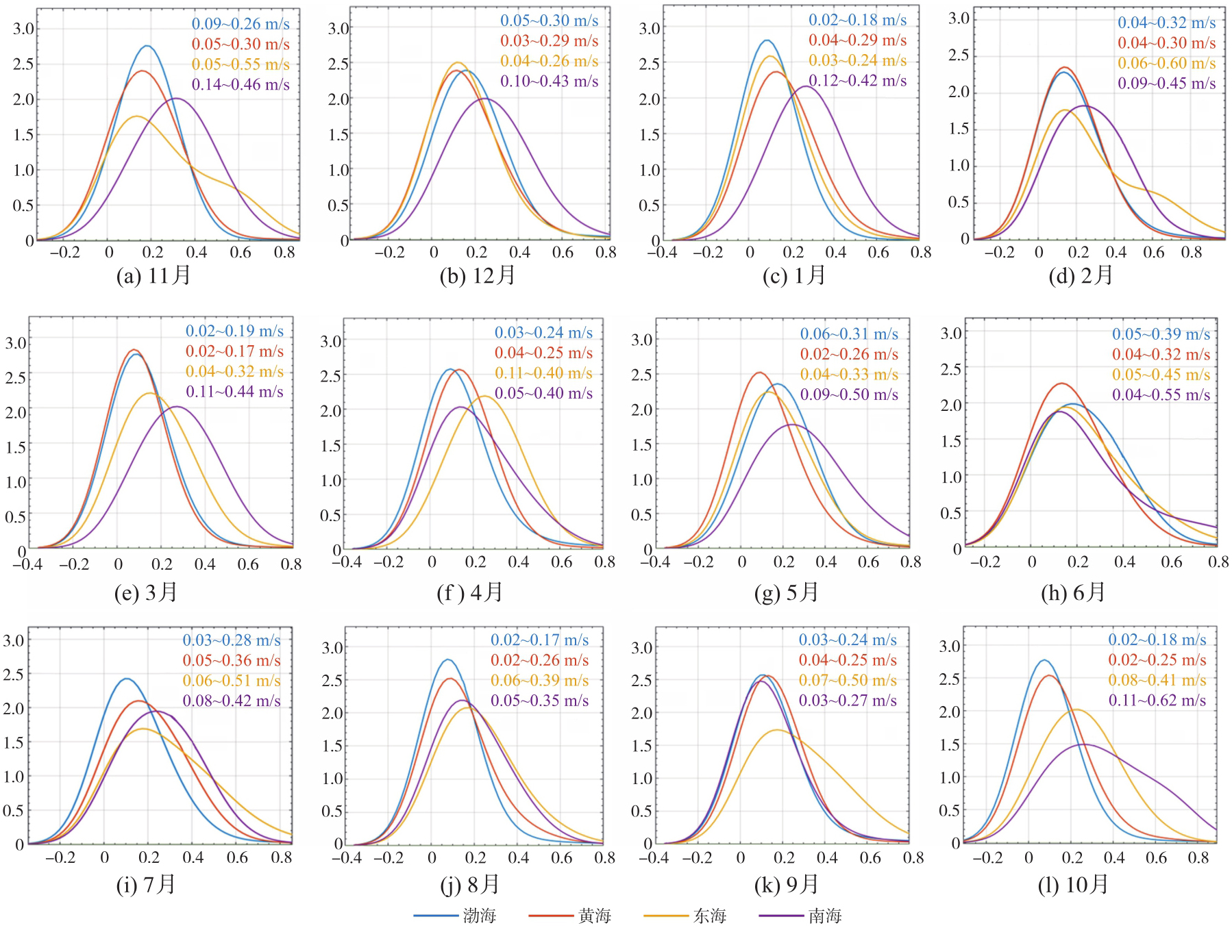
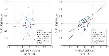
Fig. 9
Validation results comparing SAR radial velocity with in-situ current velocity measurements before and after error correction in 2021"
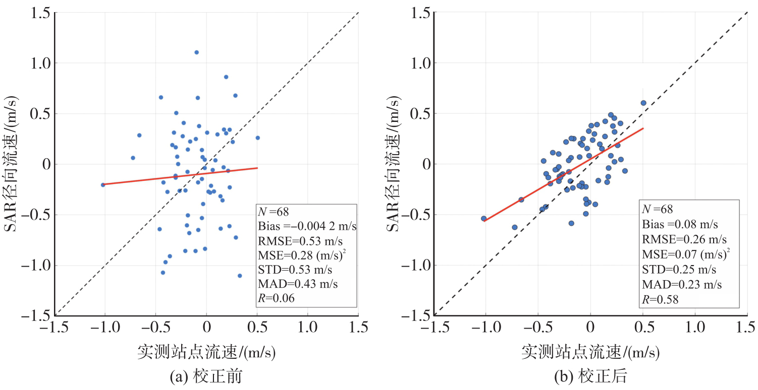
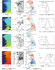
Fig. 10
Comparison of current between H-8 products and SAR-derived results"
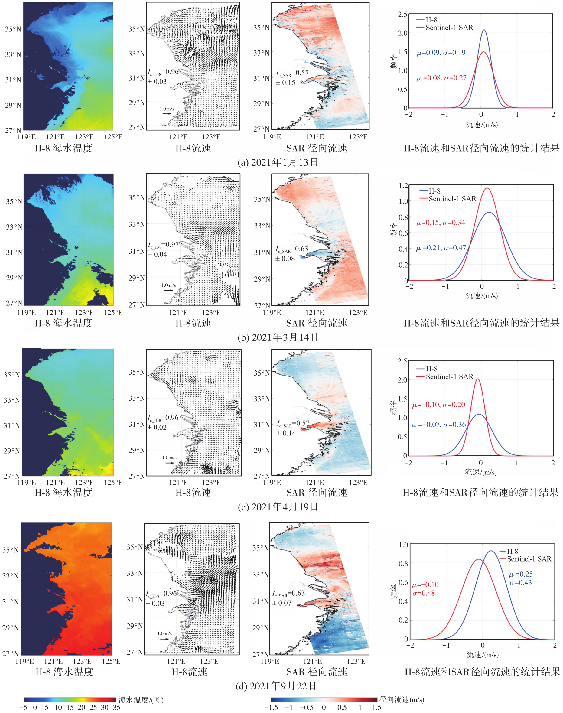
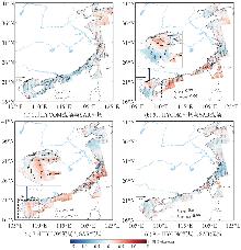
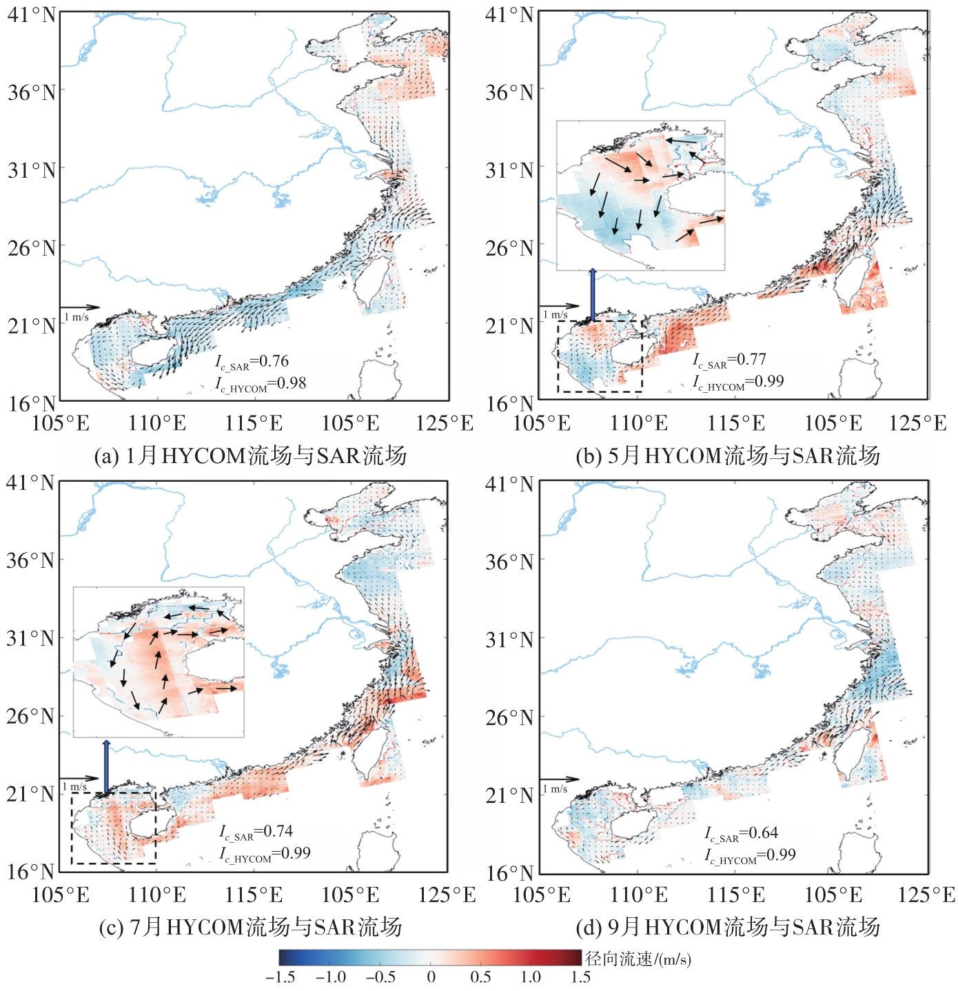
Fig. 11
Overlay results of HYCOM current vectors and SAR radial velocity for January, May, July, and September 2021"
| [1] | BOCCALETTI G, FERRARI R, ADCROFT A, et al. The vertical structure of ocean heat transport[J]. Geophysical Research Letters, 2005, 32(10): L10603. |
| [2] | DOHAN K, MAXIMENKO N. Monitoring ocean currents with satellite sensors[J]. Oceanography, 2010, 23(4): 94-103. |
| [3] | PETTERSSON L H, POZDNYAKOV D. Integrated modeling and satellite monitoring of algal blooms[M]//PETTERSSON L H, POZDNYAKOV D. Monitoring of harmful algal blooms. Berlin: Springer, 2013: 203-262. |
| [4] | ORVIK K A, SKAGSETH Ø, MORK M. Atlantic inflow to the Nordic Seas: current structure and volume fluxes from moored current meters, VM-ADCP and SeaSoar-CTD observations, 1995—1999[J]. Deep Sea Research Part I: Oceanographic Research Papers, 2001, 48(4): 937-957. |
| [5] | LUMPKIN R, ÖZGÖKMEN T, CENTURIONI L. Advances in the application of surface drifters[J]. Annual Review of Marine Science, 2017, 9: 59-81. |
| [6] | KULIKOVA D Y, GORBUNOV I G. Analysis of the sea surface parameters by Doppler X-band radar in the coastal zone of the Black Sea[C]//Proceedings of 2019 IEEE Conference of Russian Young Researchers in Electrical and Electronic Engineering. Saint Petersburg: IEEE, 2019: 1179-1182. |
| [7] | BRAKENRIDGE G R, NGHIEM S V, ANDERSON E, et al. Space-based measurement of river runoff[J]. Eos, Transactions American Geophysical Union, 2005, 86(19): 185-188. |
| [8] | KELLY K A, STRUB P T. Comparison of velocity estimates from advanced very high resolution radiometer in the Coastal Transition Zone[J]. Journal of Geophysical Research: Oceans, 1992, 97(C6): 9653-9668. |
| [9] | WILKIN J L, BOWEN M M, EMERY W J. Mapping mesoscale currents by optimal interpolation of satellite radiometer and altimeter data[J]. Ocean Dynamics, 2002, 52(3): 95-103. |
| [10] | CROCKER R I, MATTHEWS D K, EMERY W J, et al. Computing coastal ocean surface currents from infrared and ocean color satellite imagery[J]. IEEE Transactions on Geoscience and Remote Sensing, 2007, 45(2): 435-447. |
| [11] | CHEVALLIER C, HERBETTE S, MARIÉ L, et al. Observations of the Ushant front displacements with MSG/SEVIRI derived sea surface temperature data[J]. Remote Sensing of Environment, 2014, 146: 3-10. |
| [12] | HU Zifeng, LI Huadong, WANG Dongxiao. Characterizing tidal currents and Guangdong coastal current over the northern South China Sea shelf using Himawari-8 geostationary satellite observations[J]. Earth and Space Science, 2023, 10(9): e2023EA003047. |
| [13] | DANKLMAYER A, DORING B J, SCHWERDT M, et al. Assessment of atmospheric propagation effects in SAR images[J]. IEEE Transactions on Geoscience and Remote Sensing, 2009, 47(10): 3507-3518. |
| [14] | JOHANNESSEN J A, SHUCHMAN R A, JOHANNESSEN O M, et al. Synthetic aperture radar imaging of upper ocean circulation features and wind fronts[J]. Journal of Geophysical Research: Oceans, 1991, 96(C6): 10411-10422. |
| [15] | CHAPRON B, COLLARD F, ARDHUIN F. Direct measurements of ocean surface velocity from space: interpretation and validation[J]. Journal of Geophysical Research: Oceans, 2005, 110(C7): 2004JC002809. |
| [16] | WANG Lihua, TAN Benhua, CHU Xiaoqing, et al. Monitoring ocean surface current from spaceborne SAR Doppler shift[J/OL]. IEEE Geoscience and Remote Sensing Magazine, 2026: 2-24 [2026-03-10]. https://ieeexplore.ieee.org/stamp/stamp.jsp?tp=&arnumber=11410514. |
| [17] | MARTIN A C H, GOMMENGINGER C, MARQUEZ J, et al. Wind-wave-induced velocity in ATI SAR ocean surface currents: first experimental evidence from an airborne campaign[J]. Journal of Geophysical Research: Oceans, 2016, 121(3): 1640-1653. |
| [18] | WANG Lihua, TAN Benhua, CHU Xiaoqing, et al. Correction and validation of Sentinel-1 IW radial velocity products using drifter and HF radar across the entire ocean environment[J]. Remote Sensing of Environment, 2025, 328: 114909. |
| [19] | MOUCHE A A, COLLARD F, CHAPRON B, et al. On the use of Doppler shift for sea surface wind retrieval from SAR[J]. IEEE Transactions on Geoscience and Remote Sensing, 2012, 50(7): 2901-2909. |
| [20] | YUROVSKY Y Y, KUDRYAVTSEV V N, GRODSKY S A, et al. Sea surface ka-band Doppler measurements: analysis and model development[J]. Remote Sensing, 2019, 11(7): 839. |
| [21] | MOISEEV A, JOHNSEN H, HANSEN M W, et al. Evaluation of radial ocean surface currents derived from Sentinel-1 IW Doppler shift using coastal radar and Lagrangian surface drifter observations[J]. Journal of Geophysical Research: Oceans, 2020, 125(4): e2019JC015743. |
| [22] | KUDRYAVTSEV V, FAN Shengren, ZHANG Biao, et al. On the use of dual co-polarized radar data to derive a sea surface Doppler model: part 1: approach[J]. IEEE Transactions on Geoscience and Remote Sensing, 2023, 61: 4201013. |
| [23] | YANG Zhonghao, WANG Jing, LIU Lei, et al. Estimating effects of wind and waves on the Doppler centroid frequency shift for the SAR retrieval of ocean currents[J]. Remote Sensing of Environment, 2024, 311: 114312. |
| [24] | TAN Benhua, WANG Lihua, GE Dechen, et al. An investigation of inversion method to measure the radial velocity of Kuroshio from Sentinel-1 SAR data[J]. GIScience & Remote Sensing, 2024, 61(1): 2304956. |
| [25] | FANG He, XIE Tao, PERRIE W, et al. Ocean wind and current retrievals based on satellite SAR measurements in conjunction with buoy and HF radar data[J]. Remote Sensing, 2017, 9(12): 1321. |
| [26] | ZAMPARELLI V, DE SANTI F, CUCCO A, et al. Surface currents derived from SAR Doppler processing: an analysis over the Naples coastal region in south Italy[J]. Journal of Marine Science and Engineering, 2020, 8(3): 203. |
| [27] | SHAO Weizeng, JIANG Xingwei, SUN Zhanfeng, et al. Evaluation of wave retrieval for Chinese Gaofen-3 synthetic aperture radar[J]. Geo-spatial Information Science, 2022, 25(2): 229-243. |
| [28] | IQBAL M A, ANGHEL A, DATCU M. Doppler centroid estimation for ocean surface current retrieval from sentinel-1 SAR data[C]//Prceedings of 2022 European Radar Conference. London: IEEE, 2022: 429-432. |
| [29] | MOISEEV A, JOHNSEN H, JOHANNESSEN J A, et al. On removal of sea state contribution to Sentinel-1 Doppler shift for retrieving reliable ocean surface current[J]. Journal of Geophysical Research: Oceans, 2020, 125(9): e2020JC016288. |
| [30] | LIU Zhiqiang, GAN Jianping, HU Jianyu, et al. Progress on circulation dynamics in the East China Sea and southern Yellow Sea: origination, pathways, and destinations of shelf currents[J]. Progress in Oceanography, 2021, 193: 102553. |
| [31] | SCARANO F, RIETHMULLER M L. Advances in iterative multigrid PIV image processing[J]. Experiments in Fluids, 2000, 29(1): S051-S060. |
| [32] | WESTERWEEL J, SCARANO F. Universal outlier detection for PIV data[J]. Experiments in Fluids, 2005, 39(6): 1096-1100. |
| [33] | MOISEEV A, JOHANNESSEN J A, JOHNSEN H. Towards retrieving reliable ocean surface currents in the coastal zone from the Sentinel-1 Doppler shift observations[J]. Journal of Geophysical Research: Oceans, 2022, 127(5): e2021JC018201. |
| [34] | YANG Zhonghao, LIU Lei, WANG Jing, et al. Extrapolation of electromagnetic pointing error corrections for Sentinel-1 Doppler currents from land areas to the open ocean[J]. Remote Sensing of Environment, 2023, 297: 113788. |
| [35] | ZHANG Haifeng, BEGGS H, GRIFFIN C, et al. Validation of Himawari-8 sea surface temperature retrievals using infrared SST autonomous radiometer measurements[J]. Remote Sensing, 2023, 15(11): 2841. |
| [36] | ASIYABI R M, GHORBANIAN A, TAMEH S N, et al. Synthetic aperture radar (SAR) for ocean: a review[J]. IEEE Journal of Selected Topics in Applied Earth Observations and Remote Sensing, 2023, 16: 9106-9138. |
| [37] | FANG M C, YANG R Y, SHUGAN I V. Kelvin ship wake in the wind waves field and on the finite sea depth[J]. Journal of Mechanics, 2011, 27(1): 71-77. |
| [38] | ZHANG Zhixin, QIAO Fangli, GUO Jingsong, et al. Seasonal changes and driving forces of inflow and outflow through the Bohai Strait[J]. Continental Shelf Research, 2018, 154: 1-8. |
| [39] | HOLMAN R, HALLER M C. Remote sensing of the nearshore[J]. Annual Review of Marine Science, 2013, 5: 95-113. |
| [40] | SOTILLO M G, MOURRE B, MESTRES M, et al. Evaluation of the operational CMEMS and coastal downstream ocean forecasting services during the storm gloria (January 2020)[J]. Frontiers in Marine Science, 2021, 8: 644525. |
| [1] | Yi GAO, Xin LIU, Daocheng YU, Shaoshuai YA, Shaofeng BIAN, Heping SUN, Jinyun GUO. An automated seamount detection method integrating vertical gravity gradient anomaly and seafloor topographic models [J]. Acta Geodaetica et Cartographica Sinica, 2026, 55(4): 647-657. |
| [2] | Siyuan BAI, Hongzhou CHAI, Qing WU, Gen LI, Yuhao YE, Honglei MA. Buoys-aided integrated navigation method for UUV under ice with sea ice drift compensation [J]. Acta Geodaetica et Cartographica Sinica, 2026, 55(4): 698-707. |
| [3] | Jiachao BIAN, Shuqiang XUE, Shuang ZHAO, Jixing ZHU, Jinlai GAO, Baojin LI. Multi-window joint robust estimation for marine acoustic navigation [J]. Acta Geodaetica et Cartographica Sinica, 2026, 55(3): 515-524. |
| [4] | Shuqiang XUE, Jinlai GAO, Shuang ZHAO, Baojin LI, Yunhao FAN, Bingqian LIU. A static acoustic delay compensation positioning model [J]. Acta Geodaetica et Cartographica Sinica, 2026, 55(2): 275-286. |
| [5] | Qiqian SUN, Shuaidong JIA, Zhicheng LIANG, Xianpeng LIU, Haoshi SONG. A method for constructing digital depth model of strait passage considering crowdsourced bathymetric data characteristics [J]. Acta Geodaetica et Cartographica Sinica, 2026, 55(1): 90-100. |
| [6] | Gen LI, Hongzhou CHAI, Kaidi JIN, Zhao ZHAN. Underwater terrain matching method based on robust particle filter [J]. Acta Geodaetica et Cartographica Sinica, 2025, 54(10): 1841-1851. |
| [7] | Shaobo LI. Research on sub-bottom buried target detection and acoustic classification of sediment [J]. Acta Geodaetica et Cartographica Sinica, 2025, 54(10): 1911-1911. |
| [8] | Dongdong PU, Hongzhou CHAI, Yongzhong OUYANG, Chao DONG. Hierarchical encryption matching algorithm for adjacent strip splicing in airborne LiDAR bathymetry [J]. Acta Geodaetica et Cartographica Sinica, 2025, 54(8): 1439-1451. |
| [9] | Yijie ZHAO, Junting WANG, Tianhe XU, Jianxu SHU, Yangfan LIU. Correction method for time-varying sound speed errors in underwater geodetic datum positioning [J]. Acta Geodaetica et Cartographica Sinica, 2025, 54(8): 1452-1463. |
| [10] | Xiaodong CHEN, Meng YANG, Yuan YUAN, Wei FENG, Jinway HWANG, Min ZHONG. Evaluation of the accuracy and spatial resolution of SWOT_02 marine gravity model in China's offshore regions [J]. Acta Geodaetica et Cartographica Sinica, 2025, 54(6): 1031-1041. |
| [11] | Dianpeng SU, Bin WANG, Xiaozheng MAI, Huang MENG, Chao QI, Fanlin YANG. Calibration of placement angle errors of airborne bathymetric LiDAR without field control [J]. Acta Geodaetica et Cartographica Sinica, 2025, 54(6): 1042-1053. |
| [12] | Wenzhou SUN, Anmin ZENG, Zhengming QIAO. Influence of draft depth error of acoustic ray tracing on underwater positioning [J]. Acta Geodaetica et Cartographica Sinica, 2025, 54(5): 831-839. |
| [13] | Haolong GAO, Shaobo LI, Jianhu ZHAO. Multipath negative outlier removal method for coastal LiDAR point clouds based on mirror structure and intensity feature constraints [J]. Acta Geodaetica et Cartographica Sinica, 2025, 54(5): 840-852. |
| [14] | Sai MEI. Research and application of key technologies for deep-sea cold seep detection [J]. Acta Geodaetica et Cartographica Sinica, 2025, 54(3): 584-584. |
| [15] | Shaobo LI, Jianhu ZHAO, Aixue WANG, Dong DING, Yunlong WU. Three-dimensional sub-bottom profiler sonar horizon picking with structural feature constraints [J]. Acta Geodaetica et Cartographica Sinica, 2025, 54(2): 262-271. |
| Viewed | ||||||
|
Full text |
|
|||||
|
Abstract |
|
|||||