

Acta Geodaetica et Cartographica Sinica ›› 2024, Vol. 53 ›› Issue (6): 1098-1112.doi: 10.11947/j.AGCS.2024.20230405
• Smart Surveying and Mapping • Previous Articles Next Articles
Xiaogang NING( ), Hanchao ZHANG(), Ruiqian ZHANG
Received:2023-09-13
Published:2024-07-22
Contact:
Hanchao ZHANG
E-mail:ningxg@casm.ac.cn;zhanghc@casm.ac.cn
About author:NING Xiaogang (1979—), male, PhD, researcher, majors in natural resource monitoring and remote sensing applications. E-mail: ningxg@casm.ac.cn
Supported by:CLC Number:
Xiaogang NING, Hanchao ZHANG, Ruiqian ZHANG. Practical framework and methodology for high-performance intelligent invariant detection in remote sensing imagery[J]. Acta Geodaetica et Cartographica Sinica, 2024, 53(6): 1098-1112.
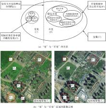
Fig.1
The relationship and examples of “change” and “unchange”"
Tab.1
Change detection dataset comparison"
| 数据集 | 分辨率/m | 变化类型 | 数据来源 | 分布地区 |
|---|---|---|---|---|
| SZTAKI[ | 1.5 | 新建城区、建筑作业、大批树木种植、耕地变化等 | 航空数据+谷歌地球 | 匈牙利佩斯州绍道 |
| ABCD[ | 0.4 | 建筑物是否被冲走 | 航空数据 | 日本东北地区 |
| WHU building CDD[ | 0.075 | 只关注建筑物变化 | 航空数据 | 克赖斯特彻奇 |
| GZCD[ | 0.55 | 只标记建筑物变化 | 谷歌地球 | 广州 |
| Lebedev-CD[ | 0.03~1 | 考虑不同大小对象变化(建筑物、道路、森林、汽车、树木、坦克等) | 谷歌地球 | — |
| LEVIR-CD[ | 0.5 | 只关注建筑相关变化 | 谷歌地球 | 美国得克萨斯州 |
| DSIFN-CD[ | 2 | 关注土地覆盖对象变化(道路、建筑物、农田、水体等地物) | 谷歌地球 | 北京、成都、深圳、重庆、武汉、西安 |
| SYSU-CD[ | 0.5 | 新建城市建筑、郊区扩张、施工前的基础工作、植被变化、道路扩建、海上建设等 | 航空数据 | 香港 |
| LIM-CD[ | 0.5~2 | 新增建设用地变化(如住宅建筑,工业、商业建设,公共、交通设施建设),特殊用途建筑(水利、园林、绿化等) | 镶嵌影像(15颗卫星) | 中国10个地形各异的省区市 |

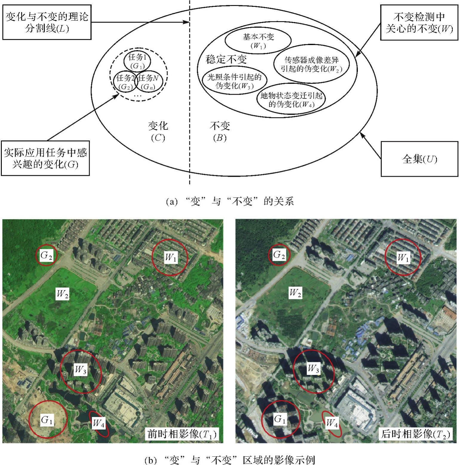
Fig.2
Ideas and concept maps of changeless detection"
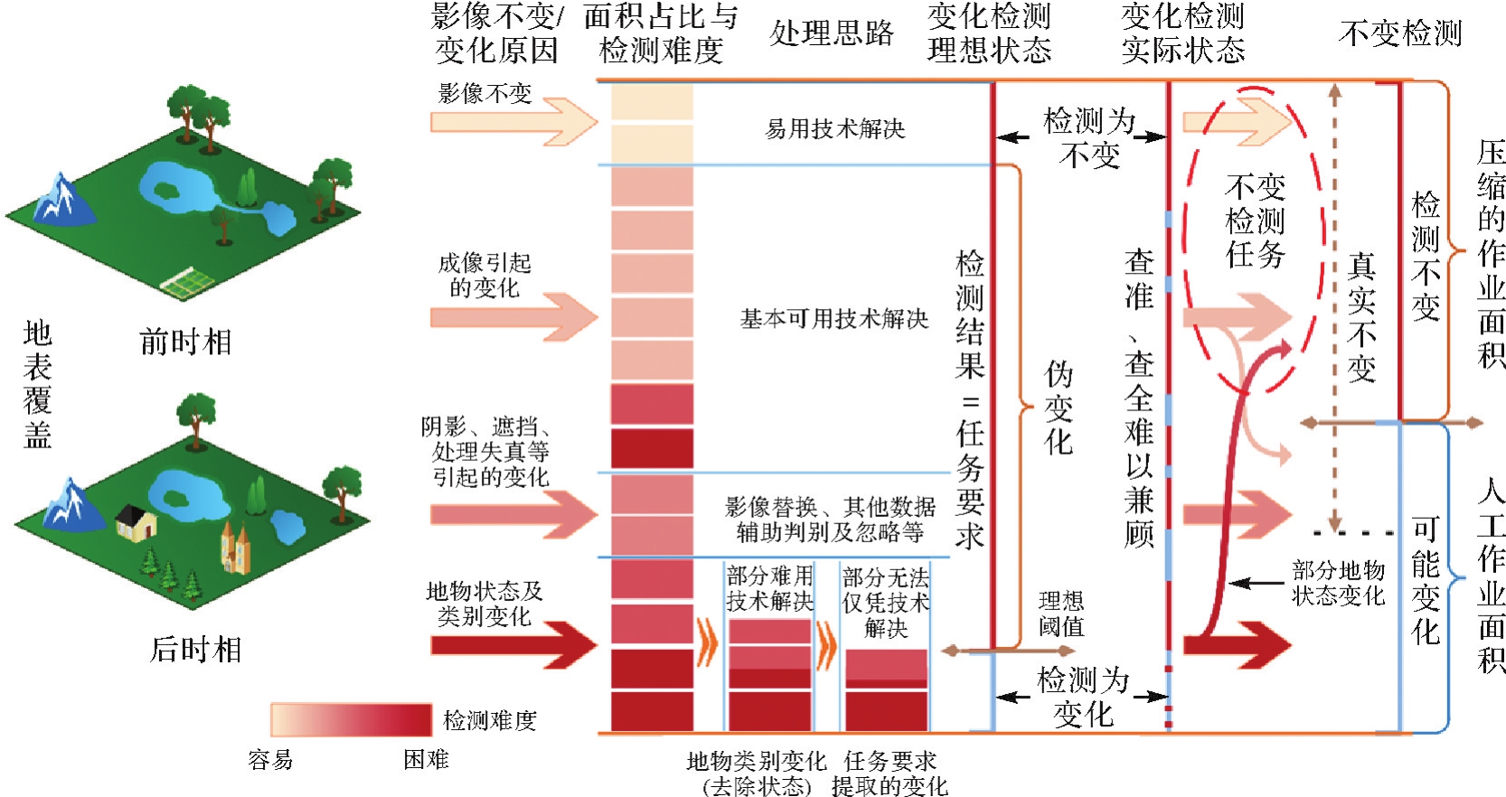

Fig.3
Technology process framework of changeless detection"
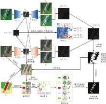
Fig.4
Global-local changeless information detection method based on prior knowledge"


Fig.5
Structure of sample library tables"
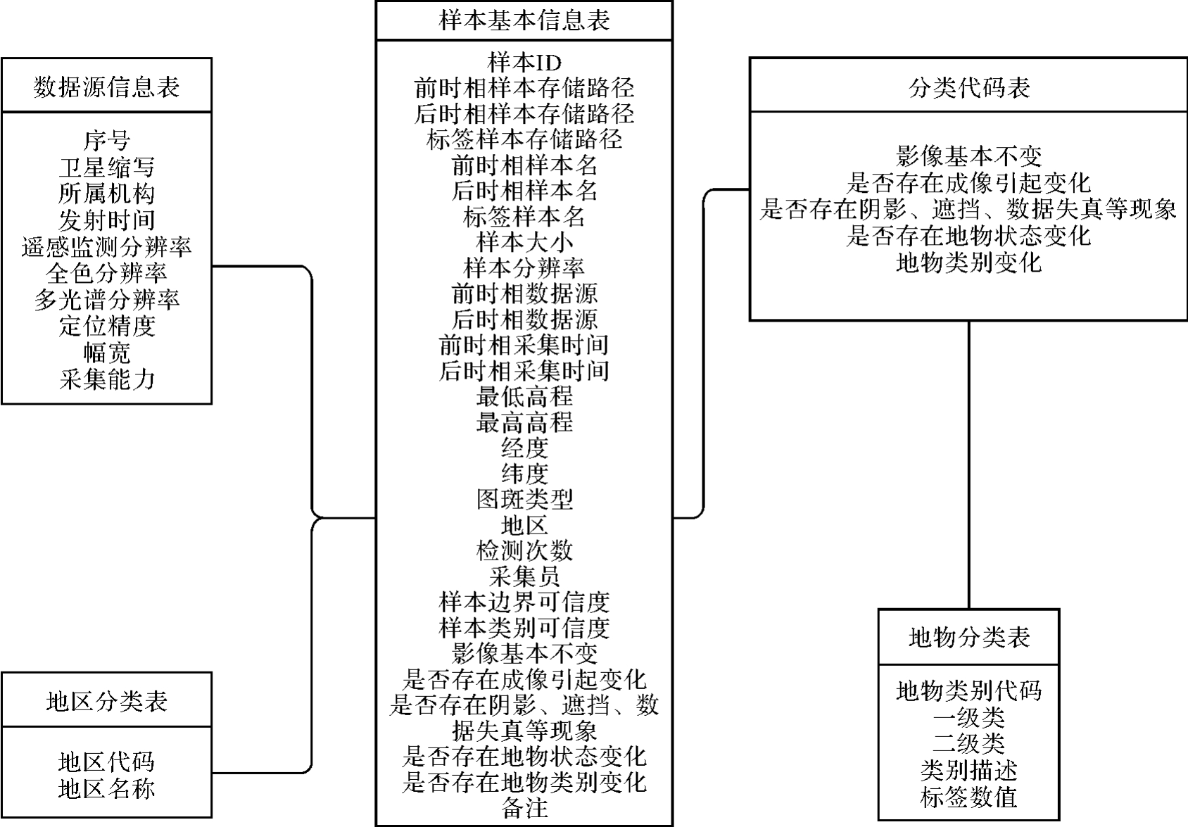

Fig.6
Relationship between compression accuracy and compression range"
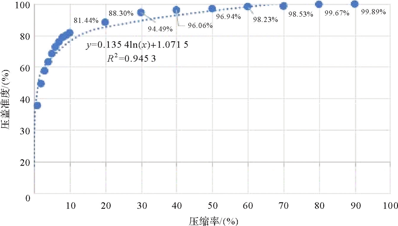

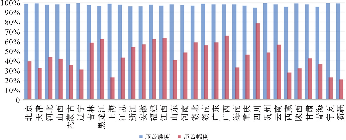
Fig.7
National holistic pseudo-change removal test results"
Tab.2
Results of the local pseudo-change removal algorithm for 15 districts and counties"
| 行政区名称 | 真实变化图斑个数 | 不变区域掩膜外的变化图斑个数 | 压盖准度/(%) | 压盖幅度/(%) |
|---|---|---|---|---|
| 北京市门头沟区 | 65 | 61 | 93.85 | 93.54 |
| 河北省石家庄市深泽县 | 65 | 61 | 93.85 | 85.41 |
| 山西省临汾市侯马市 | 33 | 31 | 93.94 | 73.82 |
| 内蒙古锡林郭勒盟正镶白旗 | 98 | 93 | 94.90 | 97.75 |
| 吉林省白山市浑江区 | 85 | 72 | 84.71 | 94.55 |
| 江苏省扬州市高邮市 | 185 | 165 | 89.19 | 93.44 |
| 浙江省杭州市桐庐县 | 153 | 141 | 92.16 | 92.31 |
| 浙江省宁波市象山县 | 268 | 223 | 83.21 | 89.25 |
| 安徽省合肥市蜀山区 | 260 | 238 | 91.54 | 77.60 |
| 安徽省六安市金安区 | 266 | 235 | 88.35 | 93.53 |
| 福建省泉州市泉港区 | 50 | 48 | 96.00 | 70.59 |
| 河南省新乡市获嘉县 | 76 | 72 | 94.74 | 83.91 |
| 湖南省长沙市雨花区 | 78 | 75 | 96.15 | 88.90 |
| 湖南省株洲市天元区 | 69 | 69 | 100.00 | 80.24 |
| 湖南省湘西土家族苗族自治州花垣县 | 107 | 92 | 85.98 | 87.34 |
| 平均 | 91.90 | 86.81 |
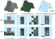
Fig.8
Example of changeless mask gridding results"

| [1] | 唐新明, 王鸿燕. 我国民用光学卫星测绘产品体系的建立与应用[J]. 测绘学报, 2022, 51(7):1386-1397. DOI:10.11947/j.AGCS.2022.20220181. |
| TANG Xinming, WANG Hongyan. Establishment and application of China civil optical satellite surveying and mapping products[J]. Acta Geodaetica et Cartographica Sinica, 2022, 51(7):1386-1397. DOI:10.11947/j.AGCS.2022.20220181. | |
| [2] | 张继贤, 顾海燕, 杨懿, 等. 自然资源要素智能解译研究进展与方向[J]. 测绘学报, 2022, 51(7):1606-1617. DOI:10.11947/j.AGCS.2022.20220109. |
| ZHANG Jixian, GU Haiyan, YANG Yi, et al. Research progress and trend of intelligent interpretation for natural resources features[J]. Acta Geodaetica et Cartographica Sinica, 2022, 51(7):1606-1617. DOI:10.11947/j.AGCS.2022.20220109. | |
| [3] | 李德仁, 张华. 我国测绘遥感技术发展的回顾与展望[J]. 中国测绘, 2019 (2):24-27. |
| LI Deren, ZHANG Hua. Review and prospect of the development of surveying and mapping remote sensing technology in China[J]. China Surveying and Mapping, 2019 (2):24-27. | |
| [4] | ASOKAN A, ANITHA J. Change detection techniques for remote sensing applications: a survey[J]. Earth Science Informatics, 2019, 12(2):143-160. |
| [5] | 龚健雅, 张觅, 胡翔云, 等. 智能遥感深度学习框架与模型设计[J]. 测绘学报, 2022, 51(4):475-487. DOI:10.11947/j.AGCS.2022.20220027. |
| GONG Jianya, ZHANG Mi, HU Xiangyun, et al. The design of deep learning framework and model for intelligent remote sensing[J]. Acta Geodaetica et Cartographica Sinica, 2022, 51(4):475-487. DOI:10.11947/j.AGCS.2022.20220027. | |
| [6] | 张兵. 遥感大数据时代与智能信息提取[J]. 武汉大学学报(信息科学版), 2018, 43(12):1861-1871. |
| ZHANG Bing. Remotely sensed big data era and intelligent information extraction[J]. Geomatics and Information Science of Wuhan University, 2018, 43(12):1861-1871. | |
| [7] | 张永军, 万一, 史文中, 等. 多源卫星影像的摄影测量遥感智能处理技术框架与初步实践[J]. 测绘学报, 2021, 50(8):1068-1083. |
| ZHANG Yongjun, WAN Yi, SHI Wenzhong, et al. Technical framework and preliminary practices of photogrammetric remote sensing intelligent processing of multi-source satellite images[J]. Acta Geodaetica et Cartographica Sinica, 2021, 50(8):1068-1083. | |
| [8] | 陈军, 刘万增, 武昊, 等. 智能化测绘的基本问题与发展方向[J]. 测绘学报, 2021, 50(8):995-1005. DOI:10.11947/j.AGCS.2021.20210235. |
| CHEN Jun, LIU Wanzeng, WU Hao, et al. Smart surveying and mapping: fundamental issues and research agenda[J]. Acta Geodaetica et Cartographica Sinica, 2021, 50(8):995-1005. DOI:10.11947/j.AGCS.2021.20210235. | |
| [9] | WAN Xue, LIU Jianguo, LI Shengyong, et al. An illumination-invariant change detection method based on dispartity saliency map for multitemporal optical remotely sensed images[J]. IEEE Transcations on Geoscience and Remote Sensing, 2018, 57(3):1311-1324. |
| [10] | LV Zhiyong, LIU Tongfei, BENEDIKTSSON J A, et al. Land cover change detection techniques: very-high-resolution optical images: a review[J]. IEEE Geoscience and Remote Sensing Magazine, 2022, 10(1):44-63. |
| [11] | LIU Sicong, MARINELLI D, BRUZZONE L, et al. A review of change detection in multitemporal hyperspectral images: current techniques, applications, and challenges[J]. IEEE Geoscience and Remote Sensing Magazine, 2019, 7(2):140-158. |
| [12] | 周启鸣. 多时相遥感影像变化检测综述[J]. 地理信息世界, 2011, 9(2):28-33. |
| ZHOU Qiming. Review on change detection using multi-temporal remotely sensed imagery[J]. Geomatics World, 2011, 9(2):28-33. | |
| [13] | 张良培, 武辰. 多时相遥感影像变化检测的现状与展望[J]. 测绘学报, 2017, 46(10):1447-1459. DOI:10.11947/j.AGCS.2017.20170340. |
| ZHANG Liangpei, WU Chen. Advance and future development of change detection for multi-temporal remote sensing imagery[J]. Acta Geodaetica et Cartographica Sinica, 2017, 46(10):1447-1459. DOI:10.11947/j.AGCS.2017.20170340. | |
| [14] | 眭海刚, 冯文卿, 李文卓, 等. 多时相遥感影像变化检测方法综述[J]. 武汉大学学报(信息科学版), 2018, 43(12):1885-1898. |
| SUI Haigang, FENG Wenqing, LI Wenzhuo, et al. Review of change detection methods for multi-temporal remote sensing imagery[J]. Geomatics and Information Science of Wuhan University, 2018, 43(12):1885-1898. | |
| [15] | CHUGHTAI A H, ABBASI H, KARAS I R. A review on change detection method and accuracy assessment for land use land cover[J]. Remote Sensing Applications: Society and Environment, 2021, 22:100482. |
| [16] | GOMEZ C, WHITE J C, WULDER M A. Optical remotely sensed time series data for land cover classification: a review[J]. ISPRS Journal of Photogrammetry and Remote Sensing, 2016, 116:55-72. |
| [17] | HAN Y, JAVED A, JUNG S, et al. Object-based change detection of very high resolution images by fusing pixel-based change detection results using weighted dempster-shafer theory[J]. Remote Sensing, 2020, 12(6):983. |
| [18] | HOSSAIN M D, CHEN Dongmei. Segmentation for object-based image analysis (OBIA): a review of algorithms and challenges from remote sensing perspective[J]. ISPRS Journal of Photogrammetry and Remote Sensing, 2019, 150:115-134. |
| [19] | 周培诚, 程塨, 姚西文, 等. 高分辨率遥感影像解译中的机器学习范式[J]. 遥感学报, 2021, 25(1):182-197. |
| ZHOU Peicheng, CHENG Gong, YAO Xiwen, et al. Machine learning paradigms in high-resolution remote sensing image interpretation[J]. National Remote Sensing Bulletin, 2021, 25(1):182-197. | |
| [20] | KHELIFI L, MIGNOTTE M. Deep learning for change detection in remote sensing images: comprehensive review and meta-analysis[J]. IEEE Access, 2020, 8:126385-126400. |
| [21] | SHI Wenzhong, ZHANG Min, ZHANG Rui, et al. Change detection based on artificial intelligence: state-of-the-art and challenges[J]. Remote Sensing, 2020, 12(10):1688. |
| [22] | GAO Yunhao, GAO Feng, DONG Junyu, et al. Change detection from synthetic aperture radar images based on channel weighting-based deep cascade network[J]. IEEE Journal of Selected Topics in Applied Earth Observations and Remote Sensing, 2019, 12(11):4517-4529. |
| [23] | ALWAN Y, CELENK M. Using combined linear regression and principal component analysis for unsupervised change detection of forest fire[C]//Proceedings of 2020 International Engineering Conference. Erbil: IEEE, 2020: 152-156. |
| [24] | JIANG Xiao, LI Gang, LIU Yu, et al. Change detection in heterogeneous optical and SAR remote sensing images via deep homogeneous feature fusion[J]. IEEE Journal of Selected Topics in Applied Earth Observations and Remote Sensing, 2020, 13:1551-1566. DOI:10.1109/JSTARS.2020.2983993. |
| [25] | WAN Ling, XIANG Yuming, YOU Hongjian. A post-classification comparison method for SAR and optical images change detection[J]. IEEE Geoscience and Remote Sensing Letters, 2019, 16(7):1026-1030. |
| [26] | 王昶, 张永生, 王旭. 基于变分法与Markov随机场模糊局部信息聚类法的SAR影像变化检测[J]. 武汉大学学报(信息科学版), 2021, 46(6):844-851. |
| WANG Chang, ZHANG Yongsheng, WANG Xu. SAR image change detection based on variational method and Markov random field fuzzy local information C-means clustering method[J]. Geomatics and Information Science of Wuhan University, 2021, 46(6):844-851. | |
| [27] | SHI Sunan, ZHONG Yanfei, ZHAO Ji, et al. Land-use/land-cover change detection based on class-prior object-oriented conditional random field framework for high spatial resolution remote sensing imagery[J]. IEEE Transactions on Geoscience and Remote Sensing, 2022, 60:3034373. |
| [28] | JING Ran, LIU Shuang, GONG Zhaoning, et al. Object-based change detection for VHR remote sensing images based on a Trisiamese-LSTM[J]. International Journal of Remote Sensing, 2020, 41(16):6209-6231. |
| [29] | 张正健, 李爱农, 雷光斌, 等. 基于多尺度分割和决策树算法的山区遥感影像变化检测方法:以四川攀西地区为例[J]. 生态学报, 2014, 34(24):7222-7232. |
| ZHANG Zhengjian, LI Ainong, LEI Guangbin, et al. Change detection of remote sensing images based on multiscale segmentation and decision tree algorithm over mountainous area: a case study in Panxi region, Sichuan province[J]. Acta Ecologica Sinica, 2014, 34(24):7222-7232. | |
| [30] | TAN Kun, ZHANG Yusha, WANG Xue, et al. Object-based change detection using multiple classifiers and multi-scale uncertainty analysis[J]. Remote Sensing, 2019, 11(3):359. |
| [31] | GANDHIMATHI A U S, VASUKI S. A novel method for segmentation and change detection of satellite images using proximal splitting algorithm and multiclass SVM[J]. Journal of the Indian Society of Remote Sensing, 2019, 47(5):853-865. |
| [32] | KHURANA M, SAXENA V. A unified approach to change detection using an adaptive ensemble of extreme learning machines[J]. IEEE Geoscience and Remote Sensing Letters, 2020, 17(5):794-798. |
| [33] | DAHY B, ISSA S, SALEOUS N. A review of land change modelling techniques using Remote sensing and GIS[C]//Proceedings of the 42nd Asian Conference on Remote Sensing. Can Tho City: Asian Association on Remote Sensing, 2021: 1-10. |
| [34] | SU Hang, ZHANG Xinzheng, LUO Yuqing, et al. Nonlocal feature learning based on a variational graph auto-encoder network for small area change detection using SAR imagery[J]. ISPRS Journal of Photogrammetry and Remote Sensing, 2022, 193:137-149. |
| [35] | SAMADI F, AKBARIZADEH G, KAABI H. Change detection in SAR images using deep belief network: a new training approach based on morphological images[J]. IET Image Processing, 2019, 13(12):2255-2264. |
| [36] | MESQUITA D B, DOS SANTOS R F, MACHARET D G, et al. Fully convolutional Siamese autoencoder for change detection in UAV aerial images[J]. IEEE Geoscience and Remote Sensing Letters, 2020, 17(8):1455-1459. |
| [37] | LI Xinghua, DU Zhengshun, HUANG Yanyuan, et al. A deep translation (GAN) based change detection network for optical and SAR remote sensing images[J]. ISPRS Journal of Photogrammetry and Remote Sensing, 2021, 179:14-34. |
| [38] | BANDARA W G C, PATEL V M. A transformer-based Siamese network for change detection[C]//Proceedings of 2022 IEEE International Geoscience and Remote Sensing Symposium. Kuala Lumpur: IEEE, 2022: 207-210. |
| [39] | IMANI M, GHASSEMIAN H. An overview on spectral and spatial information fusion for hyperspectral image classification: current trends and challenges[J]. Information Fusion, 2020, 59:59-83. |
| [40] | YOU Yanan, CAO Jingyi, ZHOU Wenli. A survey of change detection methods based on remote sensing images for multi-source and multi-objective scenarios[J]. Remote Sensing, 2020, 12(15):2460. |
| [41] | WANG Wei, ZHU Linye, LI Lingling, et al. A land trendr algorithm-based study of forest disturbance from 2000 to 2020 in Jilin province, China[J]. Polish Journal of Environmental Studies, 2022, 32(1):309-319. |
| [42] | ZHAO Xiaoyang, ZHAO Keyun, LI Siyao, et al. GeSANet: geospatial-awareness network for VHR remote sensing image change detection[J]. IEEE Transactions on Geoscience and Remote Sensing, 2023, 61:3272550. |
| [43] | HOU Xuan, BAI Yunpeng, LI Ying, et al. High-resolution triplet network with dynamic multiscale feature for change detection on satellite images[J]. ISPRS Journal of Photogrammetry and Remote Sensing, 2021, 177:103-115. |
| [44] | BENEDEK C, SZIRANYI T. Change detection in optical aerial images by a multilayer conditional mixed Markov model[J]. IEEE Transactions on Geoscience and Remote Sensing, 2009, 47(10):3416-3430. |
| [45] | FUJITA A, SAKURADA K, IMAIZUMI T, et al. Damage detection from aerial images via convolutional neural networks[C]//Proceedings of 2017 IAPR International Conference on Machine Vision Applications. Nagoya: IEEE, 2017: 5-8. |
| [46] | JI Shunping, WEI Shiqing, LU Meng. Fully convolutional networks for multisource building extraction from an open aerial and satellite imagery data set[J]. IEEE Transactions on Geoscience and Remote Sensing, 2019, 57(1):574-586. |
| [47] | PENG Daifeng, BRUZZONE L, ZHANG Yongjun, et al. SemiCDNet: a semisupervised convolutional neural network for change detection in high resolution remote-sensing images[J]. IEEE Transactions on Geoscience and Remote Sensing, 2021, 59(7):5891-5906. |
| [48] | LEBEDEV M A, VIZILTER Y V, VYGOLOV O V, et al. Change detection in remote sensing images using conditional adversarial networks[J]. ISPRS-International Archives of the Photogrammetry, Remote Sensing and Spatial Information Sciences, 2018, 422:565-571. |
| [49] | CHEN Hao, SHI Zhenwei. A spatial-temporal attention-based method and a new dataset for remote sensing image change detection[J]. Remote Sensing, 2020, 12(10):1662. |
| [50] | ZHANG Chenxiao, YUE Peng, TAPETE D, et al. A deeply supervised image fusion network for change detection in high resolution bi-temporal remote sensing images[J]. ISPRS Journal of Photogrammetry and Remote Sensing, 2020, 166:183-200. |
| [51] | SHI Qian, LIU Mengxi, LI Shengchen, et al. A deeply supervised attention metric-based network and an open aerial image dataset for remote sensing change detection[J]. IEEE Transactions on Geoscience and Remote Sensing, 2022, 60:3085870. |
| [52] | ZHANG H, ZHANG R, NING X, et al. Lim-cd: a large-scale remote sensing change detection dataset for incremental monitoring[J]. ISPRS Annals of the Photogrammetry, Remote Sensing and Spatial Information Sciences, 2023, 10:903-910. |
| [53] | 徐强强, 刘正军, 龙亚斐, 等. 面向对象的迭代加权多变量变化检测方法[J]. 遥感信息, 2017, 32(5):57-61. |
| XU Qiangqiang, LIU Zhengjun, LONG Yafei, et al. Change detection method based on object oriented IR-MAD[J]. Remote Sensing Information, 2017, 32(5):57-61. | |
| [54] | 李金基, 焦李成, 张向荣, 等. 基于两时相图像联合分类的SAR图像变化检测[J]. 红外与毫米波学报, 2009, 28(6):466-471. |
| LI Jinji, JIAO Licheng, ZHANG Xiangrong, et al. Change detection for SAR images based on joint-classification of bi-temporal images[J]. Journal of Infrared and Millimeter Waves, 2009, 28(6):466-471. | |
| [55] | NING Xiaogang, ZHANG Hanchao, ZHANG Ruiqian, et al. Multi-stage progressive change detection on high resolution remote sensing imagery[J]. ISPRS Journal of Photogrammetry and Remote Sensing, 2024, 207:231-244. |
| [56] | ZHU Liujun, WALKER J P, YE Nan, et al. Roughness and vegetation change detection: a pre-processing for soil moisture retrieval from multi-temporal SAR imagery[J]. Remote Sensing of Environment, 2019, 225:93-106. |
| [57] | 龚健雅, 许越, 胡翔云, 等. 遥感影像智能解译样本库现状与研究[J]. 测绘学报, 2021, 50(8):1013-1022. DOI:10.11947/j.AGCS.2021.20210085. |
| GONG Jianya, XU Yue, HU Xiangyun, et al. Status analysis and research of sample database for intelligent interpretation of remote sensing image[J]. Acta Geodaetica et Cartographica Sinica, 2021, 50(8):1013-1022. DOI:10.11947/j.AGCS.2021.20210085. | |
| [58] | BAKUROV I, BUZZELLI M, SCHETTINI R, et al. Structural similarity index (SSIM) revisited: a data-driven approach[J]. Expert Systems with Applications, 2022, 189:116087. |
| [59] | BAGWAN W A, SOPAN GAVALI R. Dam-triggered land use land cover change detection and comparison (transition matrix method) of Urmodi river watershed of Maharashtra, India: a remote sensing and GIS approach[J]. Geology, Ecology, and Landscapes, 2023, 7(3):189-197. |
| [60] | HOU Zengfu, LI Wei, LI Lu, et al. Hyperspectral change detection based on multiple morphological profiles[J]. IEEE Transactions on Geoscience and Remote Sensing, 2022, 60:3090802. |
| [61] | NIU Yiting, GUO Haitao, LU Jun, et al. SMNet: symmetric multi-task network for semantic change detection in remote sensing images based on CNN and transformer[J]. Remote Sensing, 2023, 15(4):949. |
| [1] | Peng LI, Jiahan ZHANG, Zhihan WANG, Houjie WANG, Zhenhong LI. A review of intertidal topography reconstruction methods: current status, challenges and trends [J]. Acta Geodaetica et Cartographica Sinica, 2026, 55(4): 571-587. |
| [2] | Lanxin WU, Jiangtao PENG, Weiwei SUN, Bing YANG. An Euler embedding and complementary feature modeling framework for hyperspectral change detection in coastal wetlands [J]. Acta Geodaetica et Cartographica Sinica, 2026, 55(4): 618-631. |
| [3] | Jiayao WANG, Lin CHEN, Shiyuan CHENG, Lijun WANG, Siqi XIONG. Artificial intelligence empowering the digital-intelligent transformation of cartographic science [J]. Acta Geodaetica et Cartographica Sinica, 2026, 55(3): 381-389. |
| [4] | Shaohua WANG, Haojian LIANG, Cheng SU, Dachuan XU, Liang ZHOU, Kun QIN. Advances and prospects in urban facility allocation optimization through coupling spatio-temporal big data and artificial intelligence [J]. Acta Geodaetica et Cartographica Sinica, 2026, 55(2): 222-235. |
| [5] | Daifeng PENG, Xuelian LIU, Mengfei LU, Haiyan GUAN. Heterogeneous remote sensing image flood change detection based on multi-scale cross-modal feature fusion [J]. Acta Geodaetica et Cartographica Sinica, 2026, 55(2): 328-343. |
| [6] | Haopeng HU, Hangbin WU, Shihao ZHAN, Zaihao WEN, Chun LIU. Road pole-like object change detection supported by visual point cloud quality optimization [J]. Acta Geodaetica et Cartographica Sinica, 2026, 55(2): 344-358. |
| [7] | Jixian ZHANG, Haiyan GU, Huan NI, Haitao LI, Yi YANG, Shaopeng DING, Songman SUI. Deep learning methods for remote sensing intelligent change detection: evolution and development [J]. Acta Geodaetica et Cartographica Sinica, 2025, 54(8): 1347-1370. |
| [8] | Chao WANG, Tianyu CHEN, Tong ZHANG, Tanvir AHMED, Liqiang JI, Tao XIE, Jiajun YANG, Shuai WANG. Multi-sensor optical remote sensing images change detection based on global differential enhancement module and balance penalty loss [J]. Acta Geodaetica et Cartographica Sinica, 2025, 54(5): 873-887. |
| [9] | Xiaohua TONG, Rong HUANG, Jiarui CAO, Chen LIU, Rong WANG, Yusheng XU, Zhen YE, Yanmin JIN, Shijie LIU, Sicong LIU, Yongjiu FENG, Huan XIE. Intelligent methods for 3D terrain reconstruction of the Moon and near-Earth planets: a review of current advances and future perspectives [J]. Acta Geodaetica et Cartographica Sinica, 2025, 54(11): 1917-1933. |
| [10] | Zhili ZHANG, Huiwei JIANG, Xiangyun HU. A minimal-interaction framework for accurate and batch extraction of geospatial objects from remote sensing imagery [J]. Acta Geodaetica et Cartographica Sinica, 2025, 54(10): 1863-1876. |
| [11] | Liangxiong GONG, Xinghua LI, Yuanming CHENG, Xingyou ZHAO, Renping XIE, Honggen WANG. A lightweight remote sensing images change detection network utilizing spatio-temporal difference enhancement and adaptive feature fusion [J]. Acta Geodaetica et Cartographica Sinica, 2025, 54(1): 136-153. |
| [12] | Xin YAN, Li SHEN, Junjie PAN, Yanshuai DAI, Jicheng WANG, Xiaoli ZHENG, Zhi-lin LI. Weakly supervised building change detection integrating multi-scale feature fusion and spatial refinement for high resolution remote sensing images [J]. Acta Geodaetica et Cartographica Sinica, 2024, 53(8): 1586-1597. |
| [13] | Haiyan GU, Yi YANG, Haitao LI, Lijian SUN, Shaopeng DING, Shiqi LIU. Dynamic construction of high-resolution remote sensing image sample datasets and intelligent interpretation applications [J]. Acta Geodaetica et Cartographica Sinica, 2024, 53(6): 1165-1179. |
| [14] | Daifeng PENG, Chenchen ZHAI, Dingwei ZHOU, Yongjun ZHANG, Haiyan GUAN, Yufu ZANG. High-resolution optical images change detection based on global information enhancement by pyramid semantic token [J]. Acta Geodaetica et Cartographica Sinica, 2024, 53(6): 1195-1211. |
| [15] | Shaopeng DING, Xiushan LU, Rufei LIU, Yi YANG, Haiyan GU, Haitao LI. Building change detection method combining object feature guidance and multiple attention mechanism [J]. Acta Geodaetica et Cartographica Sinica, 2024, 53(6): 1224-1235. |
| Viewed | ||||||
|
Full text |
|
|||||
|
Abstract |
|
|||||