

Acta Geodaetica et Cartographica Sinica ›› 2024, Vol. 53 ›› Issue (7): 1444-1457.doi: 10.11947/j.AGCS.2024.20230056
• Cartography and Geoinformation • Previous Articles Next Articles
Jichong YIN( ), Fang WU(), Renjian ZHAI, Yue QIU, Xianyong GONG, Ruixing XING
Received:2023-03-20
Published:2024-08-12
Contact:
Fang WU
E-mail:jichongy@whu.edu.cn;wufang_630@126.com
About author:YIN Jichong (1997—), male, PhD candidate, majors in intelligent processing of geospatial data. E-mail: jichongy@whu.edu.cn
Supported by:CLC Number:
Jichong YIN, Fang WU, Renjian ZHAI, Yue QIU, Xianyong GONG, Ruixing XING. Two-stream boundary constraints and relativistic generation adversarial network for building contour regularization[J]. Acta Geodaetica et Cartographica Sinica, 2024, 53(7): 1444-1457.
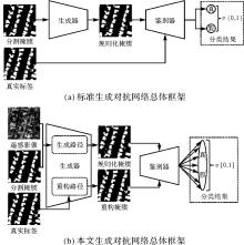
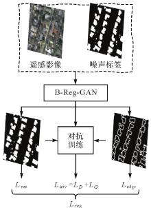
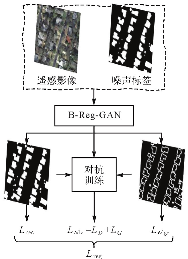
Fig.1
Overall framework of the proposed method"
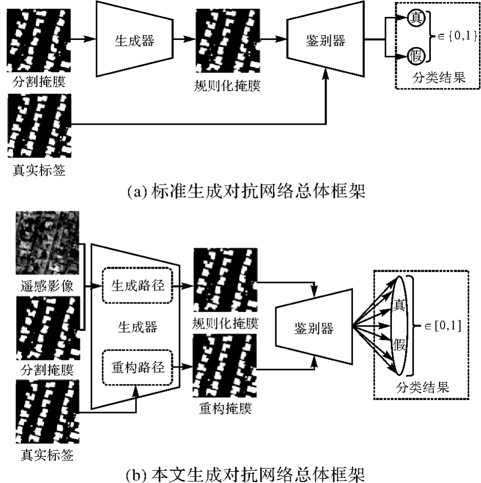
Fig.2
Detailed structure of generator network and discriminator network"
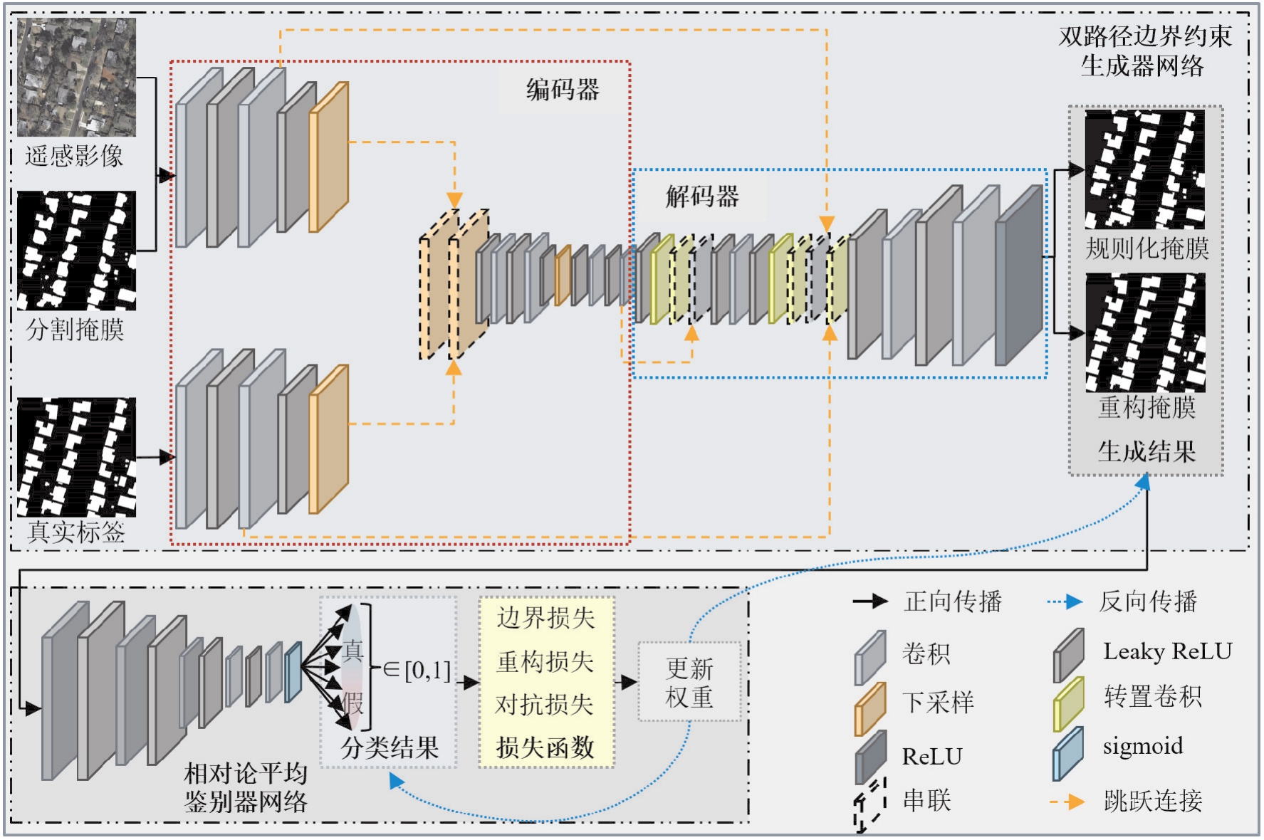
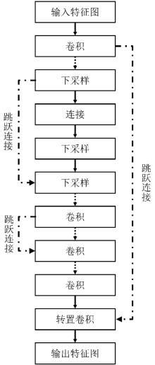
Fig.3
Skip connection structure"
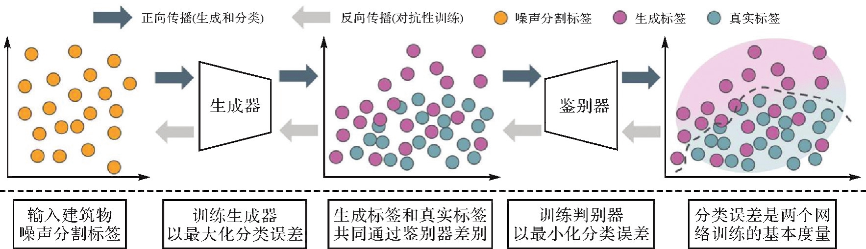
Fig.4
Backward propagation process"
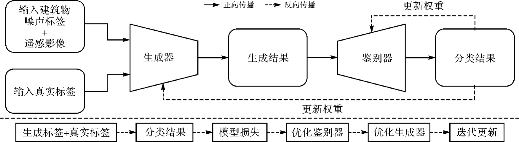
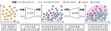
Fig.5
Minimization-maximization zero-sum game strategy"
Loss function structure"
Tab.1
Basic information of experimental data"
| 数据集 | 覆盖面积/km2 | 空间分辨率/m | 样本尺寸 | 样本数量/张 | 样本形式 | 建筑物数量/栋 | 影像来源 | ||
|---|---|---|---|---|---|---|---|---|---|
| 训练集 | 测试集 | 验证集 | |||||||
| Inria | 810 | 0.3 | 5000 | 180 | 180 | — | 栅格 | — | 航空 |
| WHU | 450 | 0.3 | 512 | 4736 | 2416 | 1036 | 矢量/栅格 | 220000 | 航空/卫星 |
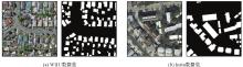
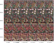
Fig.7
Experimental data samples and labels"
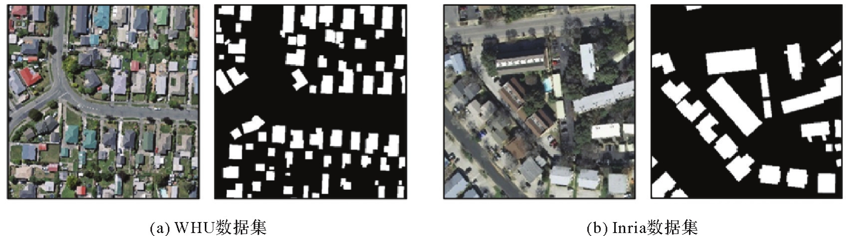

Fig.8
Comparison results of ablation experiment accuracy"
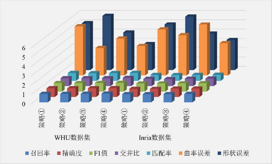

Fig.9
Visual comparison results of ablation experiment"

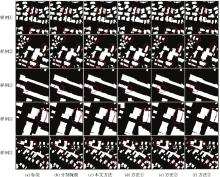
Fig.10
Experimental results of various building contour regularization methods on WHU aerial image building dataset"

Experimental results of various building contour regularization methods on Inria aerial image labeling dataset"

Accuracy evaluation results of WHU aerial image building dataset"
| 方法 | Recall/(%) | Precision/(%) | F1值/(%) | IoU/(%) | Mr/(%) | Ecur | Eshp |
|---|---|---|---|---|---|---|---|
| 分割掩膜 | 94.06 | 93.50 | 93.78 | 88.29 | 84.47 | 5.34 | 4.85 |
| 方法① | 91.42 | 94.23 | 93.25 | 87.43 | 83.04 | 2.63 | 5.23 |
| 方法② | 93.47 | 94.30 | 93.21 | 87.58 | 84.34 | 3.25 | 3.43 |
| 方法③ | 93.64 | 94.47 | 93.56 | 87.97 | 84.13 | 3.72 | 3.51 |
| 本文方法 | 93.79 | 94.72 | 94.01 | 88.77 | 85.32 | 3.17 | 2.79 |
Tab.3
Accuracy evaluation results of Inria aerial image labeling dataset"
| 方法 | Recall/(%) | Precision/(%) | F1值/(%) | IoU/(%) | Mr/(%) | Ecur | Eshp |
|---|---|---|---|---|---|---|---|
| 分割掩膜 | 89.09 | 88.77 | 88.93 | 80.06 | 63.76 | 7.65 | 6.45 |
| 方法① | 89.17 | 87.89 | 88.53 | 77.41 | 63.25 | 3.27 | 6.87 |
| 方法② | 89.53 | 89.51 | 89.52 | 81.03 | 64.46 | 5.34 | 3.84 |
| 方法③ | 88.47 | 88.16 | 88.32 | 79.09 | 64.18 | 4.86 | 4.66 |
| 本文方法 | 90.13 | 90.11 | 90.12 | 82.01 | 65.53 | 3.46 | 3.23 |
| [1] | 龚健雅, 季顺平. 摄影测量与深度学习[J]. 测绘学报, 2018, 47(6):693-704. DOI: 10.11947/j.AGCS.2018.20170640. |
| GONG Jianya, JI Shunping. Photogrammetry and deep learning[J]. Acta Geodaetica et Cartographica Sinica, 2018, 47(6):693-704. DOI: 10.11947/j.AGCS.2018.20170640. | |
| [2] | 龚健雅. 人工智能时代测绘遥感技术的发展机遇与挑战[J]. 武汉大学学报(信息科学版), 2018, 43(12):1788-1796. |
| GONG Jianya. Chances and challenges for development of surveying and remote sensing in the age of artificial intelligence[J]. Geomatics and Information Science of Wuhan University, 2018, 43(12):1788-1796. | |
| [3] | ALSHEHHI R, MARPU P R, WOON W L, et al. Simultaneous extraction of roads and buildings in remote sensing imagery with convolutional neural networks[J]. ISPRS Journal of Photogrammetry and Remote Sensing, 2017, 130:139-149. |
| [4] | DORNAIKA F, MOUJAHID A, EL MERABET Y, et al. Building detection from orthophotos using a machine learning approach: an empirical study on image segmentation and descriptors[J]. Expert Systems with Applications, 2016, 58:130-142. |
| [5] | CHEN Z, LI S, XU Y, et al. Correg-YOLOV3: a method for dense buildings detection in high-resolution remote sensing images[J]. Journal of Geodesy and Geoinformation Science, 2023, 6(2):51-61. |
| [6] | JI Shunping, WEI Shiqing, LU Meng. Fully convolutional networks for multisource building extraction from an open aerial and satellite imagery data set[J]. IEEE Transactions on Geoscience and Remote Sensing, 2019, 57(1):574-586. |
| [7] | 张玉鑫, 颜青松, 邓非. 高分辨率遥感影像建筑物提取多路径RSU网络法[J]. 测绘学报, 2022, 51(1):135-144. DOI: 10.11947/j.AGCS.2021.20200508. |
| ZHANG Yuxin, YAN Qingsong, DENG Fei. Multi-path RSU network method for high-resolution remote sensing image building extraction[J]. Acta Geodaetica et Cartographica Sinica, 2022, 51(1):135-144. DOI: 10.11947/j.AGCS.2021.20200508. | |
| [8] | 季顺平, 魏世清. 遥感影像建筑物提取的卷积神经元网络与开源数据集方法[J]. 测绘学报, 2019, 48(4):448-459. DOI: 10.11947/j.AGCS.2019.20180206. |
| JI Shunping, WEI Shiqing. Building extraction via convolutional neural networks from an open remote sensing building dataset[J]. Acta Geodaetica et Cartographica Sinica, 2019, 48(4):448-459. DOI: 10.11947/j.AGCS.2019.20180206. | |
| [9] | YUAN Jiangye. Learning building extraction in aerial scenes with convolutional networks[J]. IEEE Transactions on Pattern Analysis and Machine Intelligence, 2018, 40(11):2793-2798. |
| [10] | MAGGIORI E, TARABALKA Y, CHARPIAT G, et al. Convolutional neural networks for large-scale remote-sensing image classification[J]. IEEE Transactions on Geoscience and Remote Sensing, 2017, 55(2):645-657. |
| [11] | KANG Wenchao, XIANG Yuming, WANG Feng, et al. EU-net: an efficient fully convolutional network for building extraction from optical remote sensing images[J]. Remote Sensing, 2019, 11(23):2813. |
| [12] | 何直蒙, 丁海勇, 安炳琪. 高分辨率遥感影像建筑物提取的空洞卷积E-Unet算法[J]. 测绘学报, 2022, 51(3):457-467. DOI: 10.11947/j.AGCS.2022.20200601. |
| HE Zhimeng, DING Haiyong, AN Bingqi. E-Unet: a atrous convolution-based neural network for building extraction from high-resolution remote sensing images[J]. Acta Geodaetica et Cartographica Sinica, 2022, 51(3):457-467. DOI: 10.11947/j.AGCS.2022.20200601. | |
| [13] | QIU Yue, WU Fang, QIAN Haizhong, et al. AFL-net: attentional feature learning network for building extraction from remote sensing images[J]. Remote Sensing, 2022, 15(1):95. |
| [14] | CHEN J, LI Z, LI S, et al. From digitalized to intelligentized surveying and mapping: fundamental issues and research agenda[J]. Journal of Geodesy and Geoinformation Science, 2022, 5(2):148-160. |
| [15] | ZHENG X, HUAN L, XIA G S, et al. Parsing very high-resolution urban scene images by learning deep ConvNets with edge-aware loss[J]. ISPRS Journal of Photogrammetry and Remote Sensing, 2020, 170:15-28. |
| [16] | YIN Jichong, WU Fang, QIU Yue, et al. A multiscale and multitask deep learning framework for automatic building extraction[J]. Remote Sensing, 2022, 14(19):4744. |
| [17] | GUO Haonan, DU Bo, ZHANG Liangpei, et al. A coarse-to-fine boundary refinement network for building footprint extraction from remote sensing imagery[J]. ISPRS Journal of Photogrammetry and Remote Sensing, 2022, 183:240-252. |
| [18] | LI Qingyu, SHI Yilei, HUANG Xin, et al. Building footprint generation by integrating convolution neural network with feature pairwise conditional random field (FPCRF)[J]. IEEE Transactions on Geoscience and Remote Sensing, 2020, 58(11):7502-7519. |
| [19] | ZHAO K, KANG J, JUNG J, et al. Building extraction from satellite images using mask R-CNN with building boundary regularization[C]//Proceedings of 2018 IEEE Conference on Computer Vision and Pattern Recognition Workshops. Salt Lake City: IEEE, 2018: 247-251. |
| [20] | HE Kaiming, GKIOXARI G, DOLLÁR P, et al. Mask R-CNN[J]. IEEE Transactions on Pattern Analysis and Machine Intelligence, 2020, 42(2):386-397. |
| [21] | WEN Qi, JIANG Kaiyu, WANG Wei, et al. Automatic building extraction from google earth images under complex backgrounds based on deep instance segmentation network[J]. Sensors, 2019, 19(2):333. |
| [22] | 朱盼盼, 李帅朋, 张立强, 等. 基于多任务学习的高分辨率遥感影像建筑提取[J]. 地球信息科学学报, 2021, 23(3):514-523. |
| ZHU Panpan, LI Shuaipeng, ZHANG Liqiang, et al. Multitask learning-based building extraction from high-resolution remote sensing images[J]. Journal of Geo-Information Science, 2021, 23(3):514-523. | |
| [23] | RONNEBERGER O, FISCHER P, BROX T. U-Net: convolutional networks for biomedical image segmentation[C]//Proceedings of 2015 International Conference on Medical Image Computing and Computer-Assisted Intervention. Cham: Springer, 2015: 234-241. |
| [24] | DING Lei, TANG Hao, LIU Yahui, et al. Adversarial shape learning for building extraction in VHR remote sensing images[J]. IEEE Transactions on Image Processing: a Publication of the IEEE Signal Processing Society, 2022, 31:678-690. |
| [25] | GUO Haonan, SHI Qian, MARINONI A, et al. Deep building footprint update network: a semi-supervised method for updating existing building footprint from bi-temporal remote sensing images[J]. Remote Sensing of Environment, 2021, 264:112589. |
| [26] | WANG Zhenqing, ZHOU Yi, WANG Futao, et al. A multi-scale edge constraint network for the fine extraction of buildings from remote sensing images[J]. Remote Sensing, 2023, 15(4):927. |
| [27] | DOUGLAS D H, PEUCKER T K. Algorithms for the reduction of the number of points required to represent a digitized line or its caricature[J]. Cartographica: the International Journal for Geographic Information and Geovisualization, 1973, 10(2):112-122. |
| [28] | TASAR O, MAGGIORI E, ALLIEZ P, et al. Polygonization of binary classification maps using mesh approximation with right angle regularity[C]//Proceedings of 2018 IEEE International Geoscience and Remote Sensing Symposium. Valencia: IEEE, 2018: 6404-6407. |
| [29] | MAGGIORI E, TARABALKA Y, CHARPIAT G, et al. Polygonization of remote sensing classification maps by mesh approximation[C]//Proceedings of 2017 IEEE International Conference on Image Processing. Beijing: IEEE, 2017: 560-564. |
| [30] | GIRARD N, TARABALKA Y. End-to-end learning of polygons for remote sensing image classification[C]//Proceedings of 2018 IEEE International Geoscience and Remote Sensing Symposium. Valencia: IEEE, 2018: 2083-2086. |
| [31] | WEI Shiqing, JI Shunping, LU Meng. Toward automatic building footprint delineation from aerial images using CNN and regularization[J]. IEEE Transactions on Geoscience and Remote Sensing, 2020, 58(3):2178-2189. |
| [32] | ZORZI S, FRAUNDORFER F. Regularization of building boundaries in satellite images using adversarial and regularized losses[C]//Proceedings of 2019 IEEE International Geoscience and Remote Sensing Symposium. Yokohama: IEEE, 2019: 5140-5143. |
| [33] | LI M, LAFARGE F, MARLET R. Approximating shapes in images with low-complexity polygons[C]//Proceedings of 2020 IEEE Conference on Computer Vision and Pattern Recognition. Seattle: IEEE, 2020: 8630-8638. |
| [34] | GOODFELLOW I J, POUGET-ABADIE J, MIRZA M, et al. Generative adversarial nets[C]//Proceedings of the 27th International Conference on Neural Information Processing System. Cambridge: MIT Press, 2014: 2672-2680. |
| [35] | LIU Q, MENG X, SHAO F, et al. PSTAF-GAN: progressive spatio-temporal attention fusion method based on generative adversarial network[J]. IEEE Transactions on Geoscience and Remote Sensing, 2022, 60:5408513. |
| [36] | BENZENATI T, KESSENTINI Y, KALLEL A. Pansharpening approach via two-stream detail injection based on relativistic generative adversarial networks[J]. Expert Systems with Applications, 2022, 188:115996. |
| [37] | TANG Meng, PERAZZI F, DJELOUAH A, et al. On regularized losses for weakly-supervised CNN segmentation[C]//Proceedings of 2018 European Conference on Computer Vision. Munich: Springer, 2018: 507-522. |
| [38] | TANG Meng, DJELOUAH A, PERAZZI F, et al. Normalized cut loss for weakly-supervised CNN segmentation[C]//Proceedings of 2018 IEEE Conference on Computer Vision and Pattern Recognition. Salt Lake City: IEEE, 2018: 1818-1827. |
| [39] | CHEN Zhao, BADRINARAYANAN V, LEE Chenyu, et al. GradNorm: gradient normalization for adaptive loss balancing in deep multitask networks[C]//Proceedings of the 35th International Conference on Machine Learning. Stockholm: PMLR, 2018: 794-803. |
| [40] | MAGGIORI E, TARABALKA Y, CHARPIAT G, et al. Can semantic labeling methods generalize to any city?The Inria aerial image labeling benchmark[C]//Proceedings of 2017 IEEE International Geoscience and Remote Sensing Symposium. Fort Worth: IEEE, 2017: 3226-3229. |
| [41] | XIE Yakun, ZHU Jun, CAO Yungang, et al. Refined extraction of building outlines from high-resolution remote sensing imagery based on a multifeature convolutional neural network and morphological filtering[J]. IEEE Journal of Selected Topics in Applied Earth Observations and Remote Sensing, 2020, 13:1842-1855. |
| [42] | YE Su, PONTIUS R G J, RAKSHIT R. A review of accuracy assessment for object-based image analysis: from per-pixel to per-polygon approaches[J]. ISPRS Journal of Photogrammetry and Remote Sensing, 2018, 141:137-147. |
| [43] | PERSELLO C, BRUZZONE L. A novel protocol for accuracy assessment in classification of very high resolution images[J]. IEEE Transactions on Geoscience and Remote Sensing, 2010, 48(3):1232-1244. |
| [44] | LIZARAZO I. Accuracy assessment of object-based image classification: another STEP[J]. International Journal of Remote Sensing, 2014, 35(16):6135-6156. |
| [1] | Xin YAN, Li SHEN, Junjie PAN, Yanshuai DAI, Jicheng WANG, Xiaoli ZHENG, Zhi-lin LI. Weakly supervised building change detection integrating multi-scale feature fusion and spatial refinement for high resolution remote sensing images [J]. Acta Geodaetica et Cartographica Sinica, 2024, 53(8): 1586-1597. |
| [2] | Zhiwei XIE, Shuaizhi ZHAI, Fengyuan ZHANG, Min CHEN, Lishuang SUN. Object-oriented high-resolution image classification using inductive graph neural networks [J]. Acta Geodaetica et Cartographica Sinica, 2024, 53(8): 1610-1623. |
| [3] | Haiyan GU, Yi YANG, Haitao LI, Lijian SUN, Shaopeng DING, Shiqi LIU. Dynamic construction of high-resolution remote sensing image sample datasets and intelligent interpretation applications [J]. Acta Geodaetica et Cartographica Sinica, 2024, 53(6): 1165-1179. |
| [4] | Daifeng PENG, Chenchen ZHAI, Dingwei ZHOU, Yongjun ZHANG, Haiyan GUAN, Yufu ZANG. High-resolution optical images change detection based on global information enhancement by pyramid semantic token [J]. Acta Geodaetica et Cartographica Sinica, 2024, 53(6): 1195-1211. |
| [5] | Jicheng WANG, Anmei GUO, Li SHEN, Tian LAN, Zhu XU, Zhilin LI. Multi-level contrastive learning for weakly supervised extraction of urban solid wastes dump from high-resolution remote sensing images [J]. Acta Geodaetica et Cartographica Sinica, 2024, 53(6): 1212-1223. |
| [6] | Shaopeng DING, Xiushan LU, Rufei LIU, Yi YANG, Haiyan GU, Haitao LI. Building change detection method combining object feature guidance and multiple attention mechanism [J]. Acta Geodaetica et Cartographica Sinica, 2024, 53(6): 1224-1235. |
| [7] | LIN Yunhao, WANG Yanjun, LI Shaochun, CAI Hengfan. A coupled DeepLab and Transformer approach for fine classification of crop cultivation types in remote sensing [J]. Acta Geodaetica et Cartographica Sinica, 2024, 53(2): 353-366. |
| [8] | GU Xiaohu, LI Zhengjun, MIAO Jianhao, LI Xinghua, SHEN Huanfeng. Dual-channel parallel hybrid convolutional neural networks based classification method for high-resolution remote sensing image [J]. Acta Geodaetica et Cartographica Sinica, 2023, 52(5): 798-807. |
| [9] | HU Minghong, LI Jiatian, YAO Yanji, A Xiaohui, LU Mei, LI Wen. SER-UNet algorithm for building extraction from high-resolution remote sensing image combined with multipath [J]. Acta Geodaetica et Cartographica Sinica, 2023, 52(5): 808-817. |
| [10] | HU Anna, LIU Rui, WU Liang, ZHANG Jin, XU Yongyang, CHEN Siqiong. Super-resolution reconstruction method for remote sensing images considering global features and texture features [J]. Acta Geodaetica et Cartographica Sinica, 2023, 52(4): 648-659. |
| [11] | LIU Shuai, LI Xiaoying, YU Meng, XING Guanglong. Dual decoupling semantic segmentation model for high-resolution remote sensing images [J]. Acta Geodaetica et Cartographica Sinica, 2023, 52(4): 638-647. |
| [12] | JIANG Ming, ZHANG Xinchang, SUN Ying, FENG Weiming, RUAN Yongjian. Full-scale feature aggregation network for high-resolution remote sensing image change detection [J]. Acta Geodaetica et Cartographica Sinica, 2023, 52(10): 1738-1748. |
| [13] | ZHANG Guangbin, GAO Xianjun, RAN Shuhao, YANG Yuanwei, LI Lishan, ZHANG Yan. Accurate and lightweight cloud detection method based on cloud and snow coexistence region of high-resolution remote sensing images [J]. Acta Geodaetica et Cartographica Sinica, 2023, 52(1): 93-107. |
| [14] | GE Xiaosan, CHEN Xi, ZHAO Wenzhi, LI Ruixiang. Detection of damaged buildings based on generative adversarial networks [J]. Acta Geodaetica et Cartographica Sinica, 2022, 51(2): 238-247. |
| [15] | ZHANG Yuxin, YAN Qingsong, DENG Fei. Multi-path RSU network method for high-resolution remote sensing image building extraction [J]. Acta Geodaetica et Cartographica Sinica, 2022, 51(1): 135-144. |
| Viewed | ||||||
|
Full text |
|
|||||
|
Abstract |
|
|||||