

Acta Geodaetica et Cartographica Sinica ›› 2024, Vol. 53 ›› Issue (9): 1799-1816.doi: 10.11947/j.AGCS.2024.20230363
• Photogrammetry and Remote Sensing • Previous Articles Next Articles
Mi WANG1( ), Tengteng DONG1(), Tao PENG1, Shao XIANG1, Qiongqiong LAN1,2
Received:2023-09-08
Online:2024-10-16
Published:2024-10-16
Contact:
Tengteng DONG
E-mail:wangmi@whu.edu.cn;2022206190049@whu.edu.cn
About author:WANG Mi (1974—), male, PhD, professor, PhD supervisor, majors in high-resolution optical satellite imagery data processing and intelligent service. E-mail: wangmi@whu.edu.cn
Supported by:CLC Number:
Mi WANG, Tengteng DONG, Tao PENG, Shao XIANG, Qiongqiong LAN. Remote sensing image stripe noise removal model based on detail information constraints[J]. Acta Geodaetica et Cartographica Sinica, 2024, 53(9): 1799-1816.
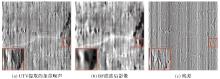
Fig.1
BF-filtered residual"
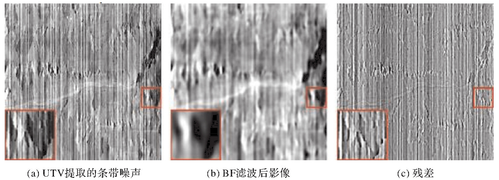
Fig.2
Analog data"
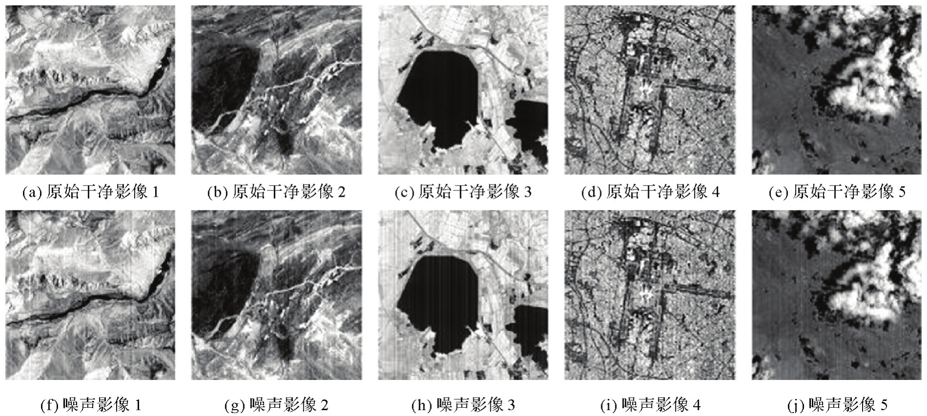
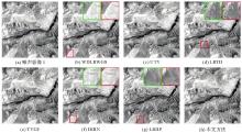
Fig.3
Noise image 1 denoising results"

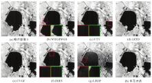
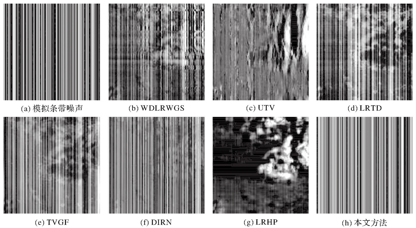
Fig.4
Noise image 3 denoising results"

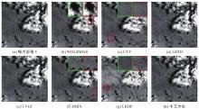
Fig.5
Noise image 5 denoising results"
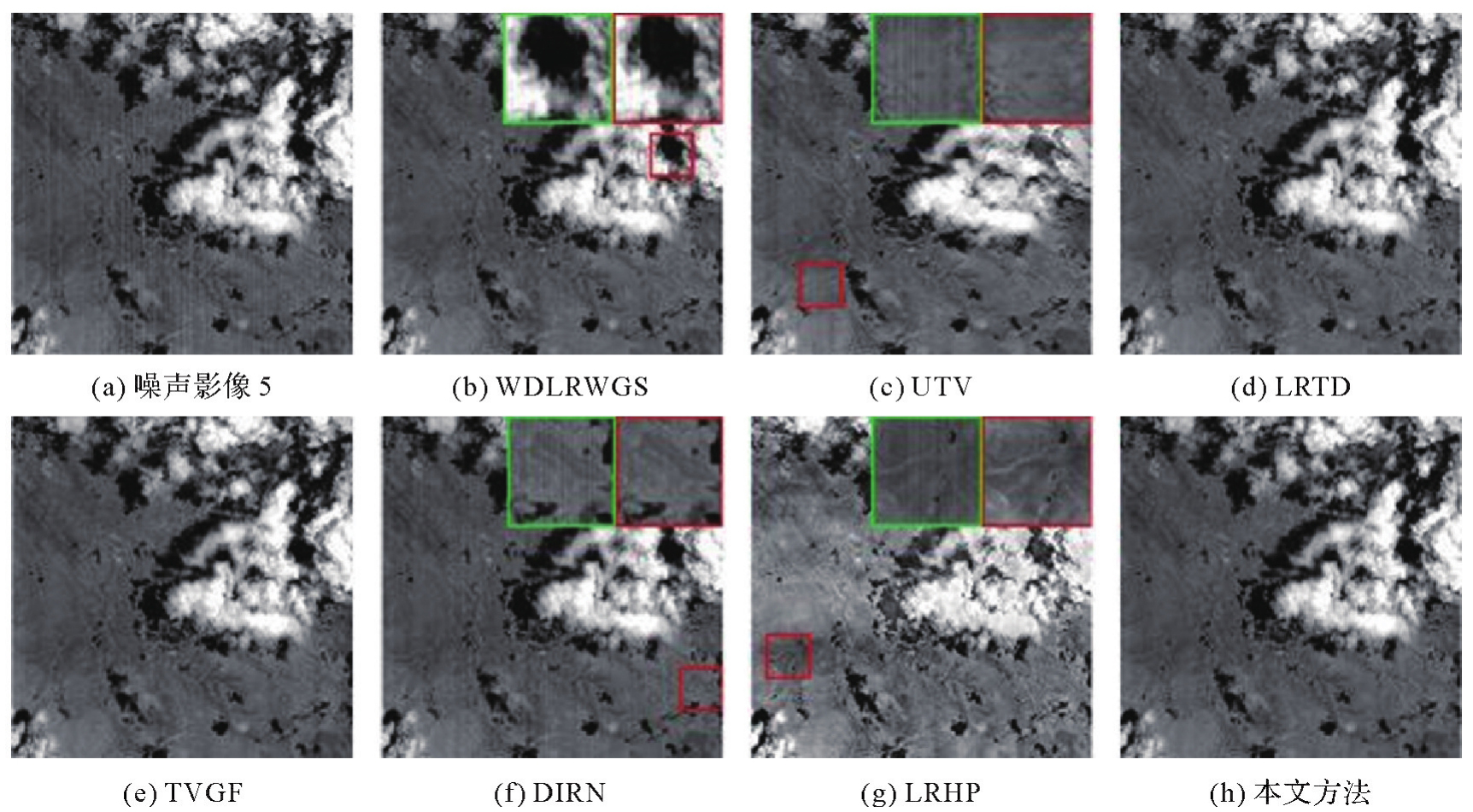

Fig.6
Noise image 1 strip noise extraction results"
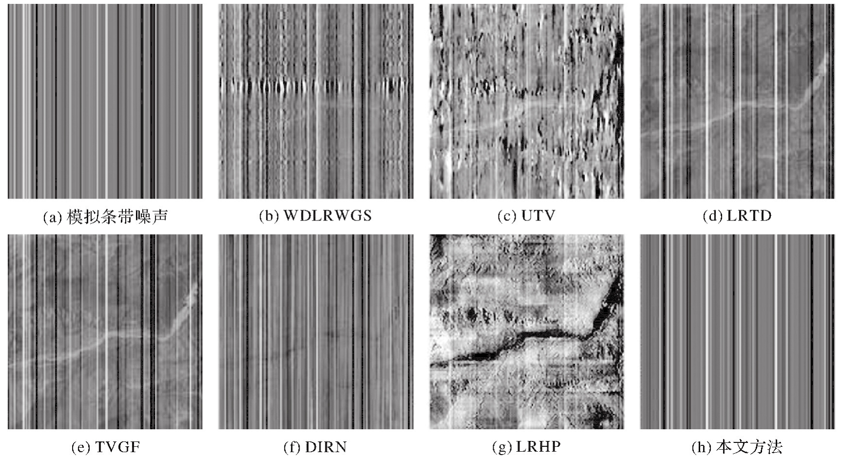
Fig.7
Noise image 3 strip noise extraction results"

Fig.8
Noise image 5 strip noise extraction results"
Tab.1
Quantitative assessment of the five simulated data"
| 影像 | 指标 | WDLRWGS | UTV | LRTD | TVGF | DIRN | LRHP | 本文方法 |
|---|---|---|---|---|---|---|---|---|
| 噪声影像1 | IS | 1.325 13 | 6.077 10 | 0.986 62 | 1.840 28 | 0.881 21 | 14.370 89 | 0.993 05 |
| IM | 0.000 13 | 0.001 17 | 0.000 08 | 0.000 19 | 0.000 05 | 0.002 98 | 0.000 01 | |
| SSIM | 0.977 67 | 0.905 25 | 0.997 33 | 0.998 74 | 0.989 06 | 0.773 78 | 0.999 63 | |
| 噪声影像2 | IS | 1.215 80 | 3.183 34 | 1.650 13 | 1.739 21 | 0.757 49 | 10.378 90 | 0.978 89 |
| IM | 0.000 23 | 0.001 19 | 0.000 39 | 0.000 40 | 0.000 13 | 0.005 07 | 0.000 01 | |
| SSIM | 0.979 99 | 0.907 89 | 0.998 48 | 0.998 14 | 0.986 54 | 0.923 52 | 0.999 32 | |
| 噪声影像3 | IS | 2.749 15 | 4.099 88 | 2.591 54 | 1.946 61 | 0.863 16 | 15.347 40 | 0.973 95 |
| IM | 0.001 50 | 0.002 49 | 0.001 43 | 0.000 77 | 0.000 22 | 0.028 61 | 0.000 03 | |
| SSIM | 0.875 91 | 0.788 50 | 0.982 69 | 0.972 57 | 0.885 28 | 0.724 37 | 0.985 58 | |
| 噪声影像4 | IS | 6.609 29 | 6.718 18 | 1.673 47 | 1.813 51 | 0.842 48 | 6.222 32 | 0.953 44 |
| IM | 0.006 59 | 0.005 90 | 0.000 76 | 0.001 02 | 0.000 35 | 0.005 21 | 0.000 16 | |
| SSIM | 0.981 85 | 0.857 07 | 0.996 58 | 0.993 45 | 0.987 90 | 0.929 46 | 0.998 97 | |
| 噪声影像5 | IS | 2.235 93 | 19.599 77 | 1.891 68 | 1.650 29 | 0.749 28 | 22.744 06 | 1.101 17 |
| IM | 0.001 20 | 0.016 38 | 0.000 81 | 0.000 86 | 0.000 35 | 0.048 87 | 0.000 32 | |
| SSIM | 0.974 46 | 0.880 79 | 0.995 36 | 0.981 21 | 0.967 33 | 0.815 50 | 0.995 67 |
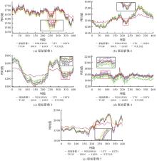
Fig.9
Column-averaged cross-trajectory curves for simulated data before and after removal of strip noise"
Fig.10
Simulation data"
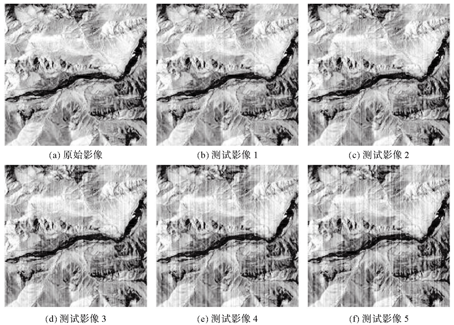
Tab.2
Quantitative evaluation of simulated data at different noise levels"
| 影像 | 指标 | WDLRWGS | UTV | LRTD | TVGF | DIRN | LRHP | 本文方法 |
|---|---|---|---|---|---|---|---|---|
| 测试影像1 | IS | 1.325 13 | 6.077 10 | 0.986 62 | 1.840 28 | 0.881 21 | 14.370 89 | 0.993 05 |
| IM | 0.000 13 | 0.001 17 | 0.000 09 | 0.000 19 | 0.000 05 | 0.002 99 | 0.000 01 | |
| SSIM | 0.977 67 | 0.905 25 | 0.997 33 | 0.998 74 | 0.989 06 | 0.773 78 | 0.999 63 | |
| 测试影像2 | IS | 1.136 28 | 4.365 11 | 0.918 53 | 1.328 23 | 0.701 87 | 9.796 84 | 0.980 72 |
| IM | 0.000 15 | 0.001 12 | 0.000 11 | 0.000 11 | 0.000 19 | 0.002 99 | 0.000 01 | |
| SSIM | 0.976 84 | 0.890 30 | 0.995 98 | 0.998 68 | 0.961 72 | 0.773 92 | 0.999 31 | |
| 测试影像3 | IS | 0.973 98 | 4.225 19 | 0.709 79 | 1.018 74 | 0.817 20 | 6.185 95 | 0.989 26 |
| IM | 0.000 11 | 0.001 85 | 0.000 05 | 0.000 04 | 0.000 30 | 0.002 98 | 0.000 02 | |
| SSIM | 0.973 98 | 0.883 26 | 0.994 00 | 0.997 32 | 0.933 51 | 0.773 83 | 0.998 15 | |
| 测试影像4 | IS | 1.491 04 | 2.413 47 | 1.108 92 | 1.481 22 | 0.724 29 | 4.399 20 | 0.952 36 |
| IM | 0.000 62 | 0.001 40 | 0.000 42 | 0.000 50 | 0.000 46 | 0.003 00 | 0.000 06 | |
| SSIM | 0.973 07 | 0.891 89 | 0.991 35 | 0.990 16 | 0.905 62 | 0.773 74 | 0.992 53 | |
| 测试影像5 | IS | 1.064 84 | 2.566 63 | 0.797 23 | 1.097 03 | 0.729 26 | 3.992 92 | 0.940 76 |
| IM | 0.000 27 | 0.001 61 | 0.000 20 | 0.000 19 | 0.000 53 | 0.003 00 | 0.000 07 | |
| SSIM | 0.970 85 | 0.897 71 | 0.989 06 | 0.989 22 | 0.892 17 | 0.773 49 | 0.990 71 |
Tab.3
Average time used by each algorithm to process the simulated data shown in Fig.2 and Fig.10"
| 指标 | WDLRWGS | UTV | LRTD | TVGF | DIRN | LRHP | 本文方法 |
|---|---|---|---|---|---|---|---|
| T | 18.266 | 24.168 | 40.744 | 23.715 | 5.483 | 5.029 | 25.355 |
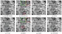
Fig.11
Real noise image 1 denoising results"
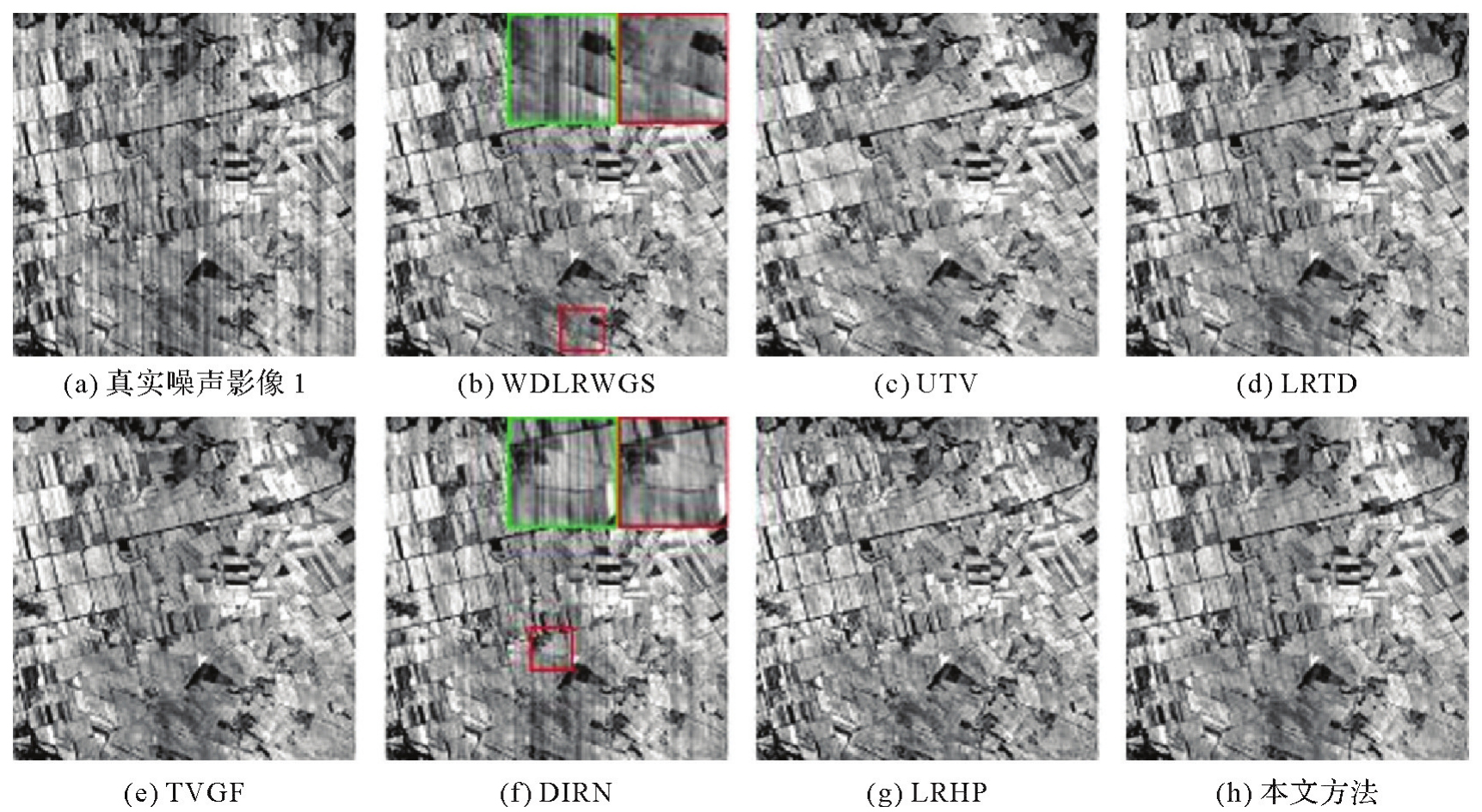
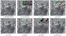
Fig.12
Real noise image 2 denoising results"
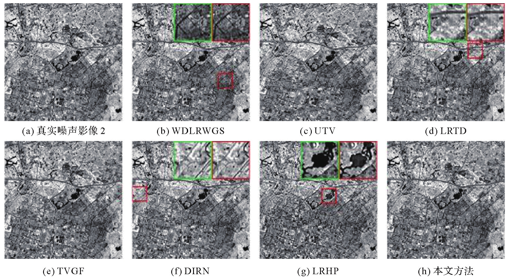
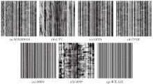
Fig.13
Real noise image 1 strip noise extraction results"
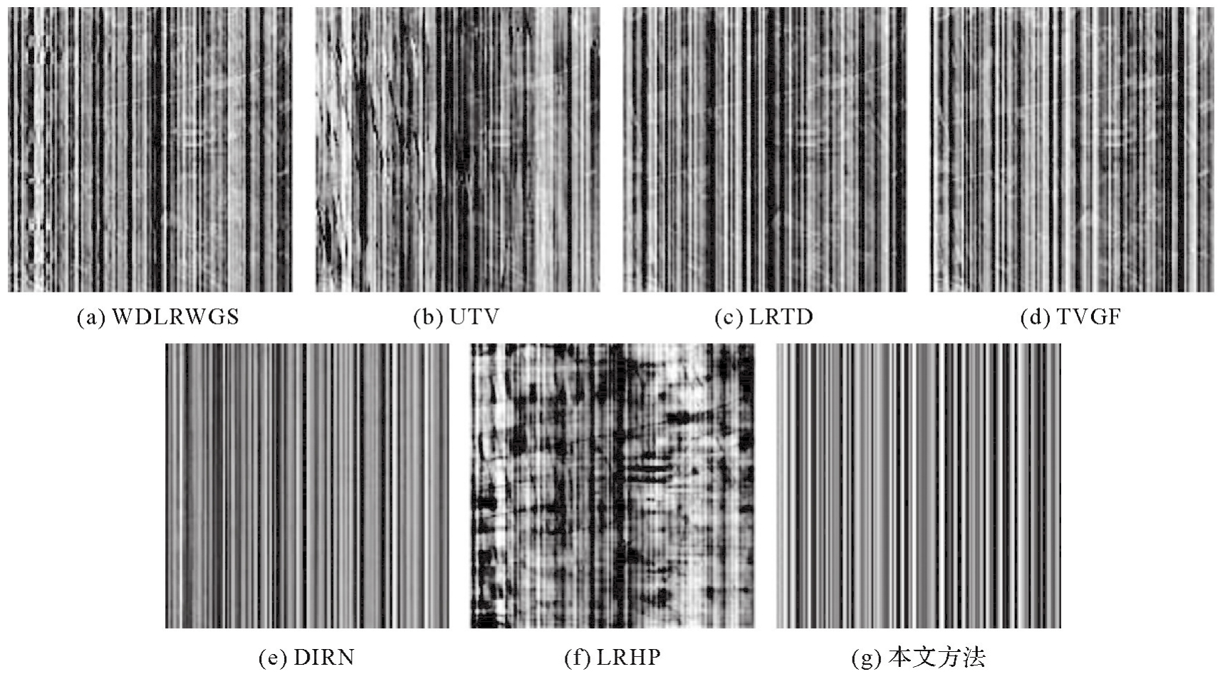
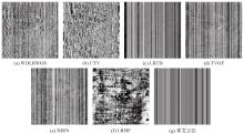
Fig.14
Real noise image 2 strip noise extraction results"
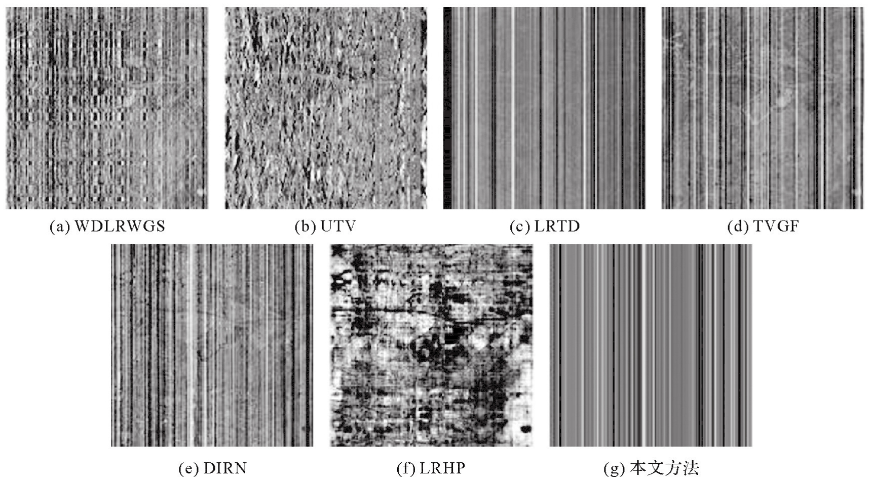
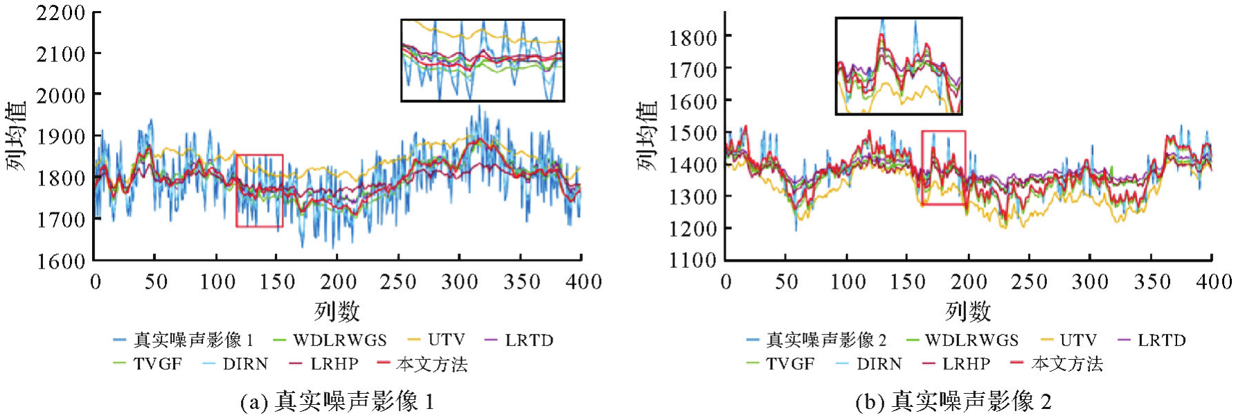
Fig.15
Average cross-trajectory curves of columns before and after denoising of real data"
Tab.4
Comparison of denoising ability and information retention ability of different algorithms"
| 影像 | 指标 | 噪声影像 | WDLRWGS | UTV | LRTD | TVGF | DIRN | LRHP | 本文方法 |
|---|---|---|---|---|---|---|---|---|---|
| 真实噪声影像1 | δ | 138.855 94 | 147.801 22 | 137.872 99 | 137.164 33 | 138.678 79 | 142.138 95 | 106.009 90 | 139.651 91 |
| PSNR | 56.996 71 | 66.197 22 | 56.099 15 | 69.571 66 | 65.311 47 | 62.086 04 | 57.844 93 | 69.900 19 | |
| SSIM | 0.854 24 | 0.979 09 | 0.945 11 | 0.993 16 | 0.989 97 | 0.932 50 | 0.843 57 | 0.993 47 | |
| H | 6.604 80 | 6.560 11 | 6.431 75 | 6.555 04 | 6.575 33 | 6.564 55 | 6.427 18 | 6.593 57 | |
| NR | 0 | 0.920 62 | 1.413 41 | 1.124 26 | 1.390 46 | 1.115 73 | 1.339 22 | 1.391 13 | |
| 真实噪声影像2 | δ | 323.049 52 | 328.230 63 | 316.036 46 | 316.548 27 | 323.549 80 | 319.592 59 | 265.940 65 | 323.565 86 |
| PSNR | 63.470 20 | 65.751 399 | 63.119 75 | 65.701 25 | 67.668 15 | 65.892 48 | 63.351 93 | 74.613 66 | |
| SSIM | 0.995 52 | 0.977 38 | 0.973 21 | 0.976 60 | 0.999 50 | 0.976 89 | 0.900 98 | 0.999 68 | |
| H | 6.370 75 | 6.372 71 | 6.336 83 | 6.372 033 | 6.372 56 | 6.365 75 | 6.200 99 | 6.374 60 | |
| NR | 0 | 0.939 95 | 1.202 94 | 0.958 07 | 1.096 46 | 1.041 65 | 1.072 50 | 1.116 32 |
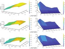
Fig.16
Effect of regularization parameters on denoising results of different noise images"

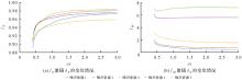
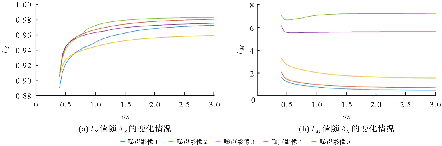
Fig.17
Effect of smoothing parameter δS"
| [1] | SHEN Huanfeng, HUANG Liwen, ZHANG Liangpei, et al. Long-term and fine-scale satellite monitoring of the urban heat island effect by the fusion of multi-temporal and multi-sensor remote sensed data: a 26-year case study of the city of Wuhan in China[J]. Remote Sensing of Environment, 2016, 172:109-125. |
| [2] | LI Xiaotong, ZHAO Xile, JIANG Taixiang, et al. Low-rank tensor completion via combined non-local self-similarity and low-rank regularization[J]. Neurocomputing, 2019, 367:1-12. |
| [3] | DING Meng, HUANG Tingzhu, JI Tengyu, et al. Low-rank tensor completion using matrix factorization based on tensor train rank and total variation[J]. Journal of Scientific Computing, 2019, 81(2):941-964. |
| [4] | ACITO N, DIANI M, CORSINI G. Subspace-based striping noise reduction in hyperspectral images[J]. IEEE Transactions on Geoscience and Remote Sensing, 2011, 49(4):1325-1342. |
| [5] | KAMIRU L, HAKIM P R, HASBI W. An adaptive stripe noise removal algorithm for optical satellite imagery[C]//Proceedings of 2019 IEEE International Conference on Aerospace Electronics and Remote Sensing Technology. Yogyakarta: IEEE, 2019: 1-7. |
| [6] | JIANG Hongxu, MIAO Rui, CHEN Jiao, et al. A resource-efficient parallel architecture for infrared image stripe noise removal based on the most stable window[J]. Infrared Physics & Technology, 2019, 97:258-269. |
| [7] | 李文力, 李凯, 彭迪, 等. AGRI遥感图像中条带噪声的分析与去除[J]. 光学学报, 2019, 39(12):1228004. |
| LI Wenli, LI Kai, PENG Di, et al. Analysis and removal of stripe noise in AGRI remote-sensing images[J]. Acta Optica Sinica, 2019, 39(12):1228004. | |
| [8] | CUI Hao, JIA Peng, ZHANG Guo, et al. Multiscale intensity propagation to remove multiplicative stripe noise from remote sensing images[J]. IEEE Transactions on Geoscience and Remote Sensing, 2020, 58(4):2308-2323. |
| [9] | QU Yufu, ZHANG Xuan, WANG Qianyi, et al. Extremely sparse stripe noise removal from non remote-sensing images by straight line detection and neighborhood grayscale weighted replacement[J]. IEEE Access, 2018, 6:76924-76934. |
| [10] | QU Xiaofei, ZHAO Weiwei, LONG En, et al. Removal of stripes in remote sensing images based on statistics combined with image enhancement[J]. Journal of Geodesy and Geoinformation Science, 2023, 6(1):76-87. |
| [11] | 张霞, 孙伟超, 帅通, 等. 基于小波变换的图像条带噪声去除方法[J]. 遥感技术与应用, 2015, 30(6):1168-1175. |
| ZHANG Xia, SUN Weichao, SHUAI Tong, et al. Image destriping method based on wavelet transform[J]. Remote Sensing Technology and Application, 2015, 30(6):1168-1175. | |
| [12] | LI M, NONG S, NIE T, et al. An infrared stripe noise removal method based on multi-scale wavelet transform and multi-nomial sparse representation[J]. Computational Intelligence and Neuroscience, 2022:4044071. |
| [13] | SHAO Yuyi, SUN Yingwei, ZHAO Mengmeng, et al. Infrared image stripe noise removing using least squares and gradient domain guided filtering[J]. Infrared Physics & Technology, 2021, 119:103968. |
| [14] | 陈劲松, 邵芸, 朱博勤. 中分辨率遥感图像条带噪声的去除[J]. 遥感学报, 2004(3):227-233. |
| CHEN Jinsong, SHAO Yun, ZHU Boqin. Removal of strip noise from medium-resolution remote sensing images[J]. Journal of Remote Sensing, 2004(3):227-233. | |
| [15] | FAYYAZ Z, PLATNICK D, FAYYAZ H, et al. Deep unfolding for iterative stripe noise removal[C]//Prcoceedings of 2022 International Joint Conference on Neural Networks. Padua: IEEE, 2022: 1-7. |
| [16] | GUAN Juntao, LAI Rui, XIONG Ai. Wavelet deep neural network for stripe noise removal[J]. IEEE Access, 2019, 7:44544-44554. |
| [17] | BOUALI M, LADJAL S. Toward optimal destriping of MODIS data using a unidirectional variational model[J]. IEEE Transactions on Geoscience and Remote Sensing, 2011, 49(8):2924-2935. |
| [18] | LIU Na, LI Wei, TAO Ran, et al. Wavelet-domain low-rank/group-sparse destriping for hyperspectral imagery[J]. IEEE Transactions on Geoscience and Remote Sensing, 2019, 57(12):10310-10321. |
| [19] | CHEN Yong, HUANG Tingzhu, ZHAO Xile. Destriping of multispectral remote sensing image using low-rank tensor decomposition[J]. IEEE Journal of Selected Topics in Applied Earth Observations and Remote Sensing, 2018, 11(12):4950-4967. |
| [20] | WANG Ende, JIANG Ping, LI Xuepeng, et al. Infrared stripe correction algorithm based on wavelet decomposition and total variation-guided filtering[J]. Journal of the European Optical Society-Rapid Publications, 2020, 16:1. |
| [21] | ZHAO Shuheng, YUAN Qiangqiang, LI Jie, et al. A fast and effective irregular stripe removal method for moon mineralogy mapper (M3)[J]. IEEE Transactions on Geoscience and Remote Sensing, 2022, 60:1-19. |
| [22] | WANG Chang, ZHANG Yongsheng, WANG Xu, et al. An effective strip noise removal method for remote sensing image[J]. Journal of Geodesy and Geoinformation Science, 2022, 5(4):72-85. |
| [23] | 王昶, 王旭, 纪松. 采用变分法的遥感影像条带噪声去除[J]. 西安交通大学学报, 2019, 53(3):143-149. |
| WANG Chang, WANG Xu, JI Song. Stripe noise removal of remote images based on variation[J]. Journal of Xi'an Jiaotong University, 2019, 53(3):143-149. | |
| [24] | 陈柳, 陈明举, 吴浩, 等. 一种群稀疏限制的消除条带噪声变分模型[J]. 液晶与显示, 2020, 35(6):604-611. |
| CHEN Liu, CHEN Mingju, WU Hao, et al. Variation model with group sparsity constraint for stripe noise removal[J]. Chinese Journal of Liquid Crystals and Displays, 2020, 35(6):604-611. | |
| [25] | 李凯, 李文力, 韩昌佩. 基于L1范数优化模型的遥感图像条纹去除方法[J]. 红外与毫米波学报, 2021, 40(2):272-283. |
| LI Kai, LI Wenli, HAN Changpei. Remote sensing image stripe removal method based on L1-paradigm optimization model[J]. Journal of Infrared and Millimeter Wave, 2021, 40(2):272-283. | |
| [26] | CHANG Yi, YAN Luxin, WU Tao, et al. Remote sensing image stripe noise removal: from image decomposition perspective[J]. IEEE Transactions on Geoscience and Remote Sensing, 2016, 54(12):7018-7031. |
| [27] | ZHANG Shengwei, XIANG Wei, XU Baoshu, et al. Stripe noise removal for infrared images using guided filter[C]//Proceedings of 2016 Infrared Technology and Applications, and Robot Sensing and Advanced Control. Beijing: SPIE, 2016: 665-673. |
| [28] | 鞠荟荟, 刘志刚, 姜江军, 等. 基于低通滤波残差图的高光谱条带噪声去除[J]. 光学学报, 2018, 38(12):361-369. |
| JU Huihui, LIU Zhigang, JIANG Jiangjun, et al. Hyperspectral stripe noise removal based on low-pass filtered residual map[J]. Journal of Optics, 2018, 38(12):361-369. | |
| [29] | REN Longfei, HONG Danfeng, GAO Lianru, et al. Orthogonal subspace unmixing to address spectral variability for hyperspectral image[J]. IEEE Transactions on Geoscience and Remote Sensing, 2023, 61:1-13. |
| [30] | REN Longfei, WANG Chengjing, TANG Peipei, et al. A dual symmetric Gauss-Seidel alternating direction method of multipliers for hyperspectral sparse unmixing[J]. Numerical Algorithms, 2021, 87(2):719-754. |
| [31] | REN Longfei, MA Zheng, BOVOLO F, et al. Hyperspectral unmixing using weighted sparse regression with total variation regularization[J]. International Journal of Remote Sensing, 2022, 43(15/16):6124-6151. |
| [32] | YANG Jinghua, ZHAO Xile, MA Tianhui, et al. Remote sensing images destriping using unidirectional hybrid total variation and nonconvex low-rank regularization[J]. Journal of Computational and Applied Mathematics, 2020, 363:124-144. |
| [33] | CHEN Yong, HUANG Tingzhu, ZHAO Xile, et al. Stripe noise removal of remote sensing images by total variation regularization and group sparsity constraint[J]. Remote Sensing, 2017, 9(6):559. |
| [1] | Peng LI, Jiahan ZHANG, Zhihan WANG, Houjie WANG, Zhenhong LI. A review of intertidal topography reconstruction methods: current status, challenges and trends [J]. Acta Geodaetica et Cartographica Sinica, 2026, 55(4): 571-587. |
| [2] | bolin FU, Keyue HUANG, Yanli YANG, Weiwei SUN, Zhaoyin WANG. Multi-scene analysis of mangrove soil spectral response characteristics and inversion of soil organic carbon content based on measured full-spectrum hyperspectral data [J]. Acta Geodaetica et Cartographica Sinica, 2026, 55(4): 604-617. |
| [3] | Lanxin WU, Jiangtao PENG, Weiwei SUN, Bing YANG. An Euler embedding and complementary feature modeling framework for hyperspectral change detection in coastal wetlands [J]. Acta Geodaetica et Cartographica Sinica, 2026, 55(4): 618-631. |
| [4] | Ertao GAO, Jing LIU, Shujin LI, Guoqing ZHOU, Bolin FU, Shuxian LI. Multi-dimensional spatiotemporal monitoring and analysis of tidal flats in the Maowei Sea using integrated optical remote sensing and SAR [J]. Acta Geodaetica et Cartographica Sinica, 2026, 55(4): 632-646. |
| [5] | Hao XU, Nan XU, Huichao XIN, Yue MA, Wei TU, Qingquan LI. A topographic photon extraction method for intertidal zones using ICESat-2 satellite altimeter data [J]. Acta Geodaetica et Cartographica Sinica, 2026, 55(4): 658-672. |
| [6] | Jinwei BU, Shuhui LIU, Shunshuang XU, Tongsu XIANG, Qiulan WANG, Chaoying JI, Xiaoqing ZUO. Construction of an empirical model for estimating the global wave period of spaceborne GNSS-R [J]. Acta Geodaetica et Cartographica Sinica, 2026, 55(4): 684-697. |
| [7] | Zexin YANG. Research on key technologies for reconstructing building models with multi-LODs using point clouds [J]. Acta Geodaetica et Cartographica Sinica, 2026, 55(4): 755-755. |
| [8] | Yongxiang YAO. Generalized similarity feature-based robust matching of multi-modal remote sensing images [J]. Acta Geodaetica et Cartographica Sinica, 2026, 55(4): 757-757. |
| [9] | Dong XU. Research on key technologies of global localization using multisource geo-referenced point cloud [J]. Acta Geodaetica et Cartographica Sinica, 2026, 55(4): 760-760. |
| [10] | Chenming YE, Zhizhong KANG, Jinhao CAI, Bingzheng ZUO, Shuai SHAO, Yan LI. A morphology-guided real-scene 3D modeling method of lunar geo-entities [J]. Acta Geodaetica et Cartographica Sinica, 2026, 55(3): 525-535. |
| [11] | Meilian WANG. Machine learning based methods for tree species classification and wood-leaf separation from handheld LiDAR data [J]. Acta Geodaetica et Cartographica Sinica, 2026, 55(3): 569-569. |
| [12] | Daifeng PENG, Xuelian LIU, Mengfei LU, Haiyan GUAN. Heterogeneous remote sensing image flood change detection based on multi-scale cross-modal feature fusion [J]. Acta Geodaetica et Cartographica Sinica, 2026, 55(2): 328-343. |
| [13] | Haopeng HU, Hangbin WU, Shihao ZHAN, Zaihao WEN, Chun LIU. Road pole-like object change detection supported by visual point cloud quality optimization [J]. Acta Geodaetica et Cartographica Sinica, 2026, 55(2): 344-358. |
| [14] | Donghang YU. Research on scene and object recognition in high resolution remote sensing images [J]. Acta Geodaetica et Cartographica Sinica, 2026, 55(2): 377-377. |
| [15] | Bin HAN, Xin HUANG, Fengyi LI, Xiaozhen LU. Water body segmentation network for SAR images combining dual-encoder and adaptive feature fuse [J]. Acta Geodaetica et Cartographica Sinica, 2026, 55(1): 101-113. |
| Viewed | ||||||
|
Full text |
|
|||||
|
Abstract |
|
|||||