

Acta Geodaetica et Cartographica Sinica ›› 2026, Vol. 55 ›› Issue (7): 1229-1239.doi: 10.11947/j.AGCS.2026.20250503
• Geodesy and Navigation • Previous Articles
Xi Zhao( ), Qiangqiang Yuan(), Jiadan Xu
Received:2025-11-27
Revised:2026-07-01
Published:2026-08-18
Contact:
Qiangqiang Yuan
E-mail:2024102140065@whu.edu.cn;yqiang86@gmail.com
About author:Zhao Xi (2000—), famale, PhD candidiate, majors in underwater target detection, sonar data processing, sediment classification, underwater navigation and positioning, et al. E-mail: 2024102140065@whu.edu.cn
Supported by:CLC Number:
Xi Zhao, Qiangqiang Yuan, Jiadan Xu. A sample generation and enhancement method for side-scan sonar targets in complex marine environments[J]. Acta Geodaetica et Cartographica Sinica, 2026, 55(7): 1229-1239.
Fig. 1
Technical route for underwater target sample generation and enhancement to estimate SSS imaging mechanism and marine environment"
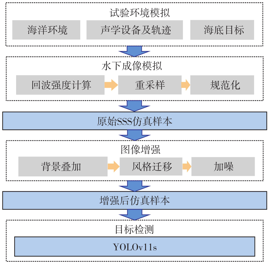
Fig. 2
SSS imaging principles"
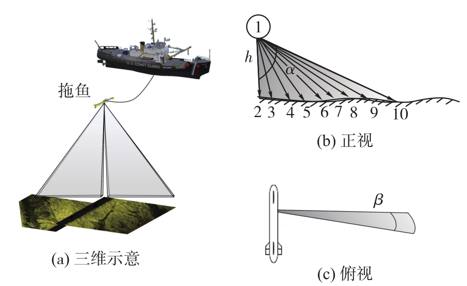
Fig. 3
SSS equidistant side-scan sonar radiographic imaging of underwater targets"
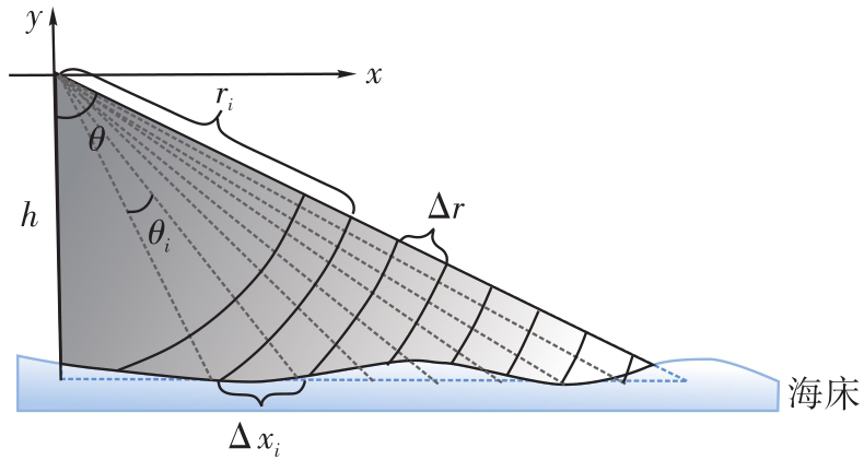
Fig. 4
Data processing flowchart of the improved style transfer method"
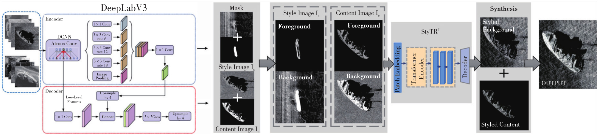
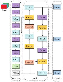
Fig. 5
Network structure of YOLOv11s"
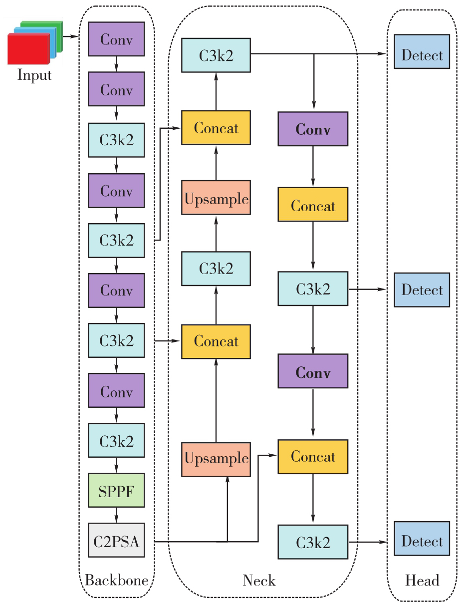
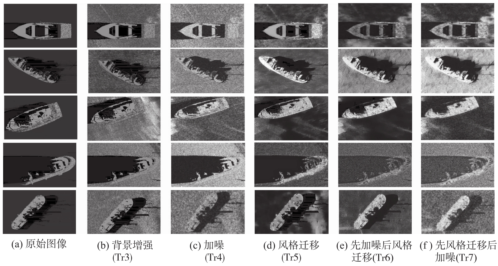
Fig. 6
Images of the sunken ship under different postures simulated by various methods"

Tab. 1
Samples information used to train and test detection model"
| 数据集类型 | 样本 | 训练集 | 数据集样本量 |
|---|---|---|---|
| 测试集 | 实测SSS样本 | Te | 101 |
| 训练集 | 实测SSS样本 | Tr1 | 328 |
| 基于Tr1进行旋转、缩放操作扩增后的SSS样本 | Tr1* | 854 | |
| 原始仿真SSS样本 | Tr2 | 427 | |
| 仿真目标与背景叠加后样本 | Tr3 | 854 | |
| Tr3基础上加噪后的仿真SSS样本 | Tr4 | 854 | |
| Tr3基础上风格迁移后的仿真SSS样本 | Tr5 | 854 | |
| Tr3基础上先加噪后风格迁移的仿真样本 | Tr6 | 854 | |
| Tr3基础上先风格迁移后加噪的仿真样本 | Tr7 | 854 | |
| 部分Tr7仿真样本(526张)与Tr1实测样本(328张)合集 | Tr7* | 854 | |
| 全部仿真样本(Tr2—Tr7) | Tr8 | 4697 |
Tab. 2
Target detection results"
| 模型 | 训练集 | P | R | mAP(0.5) | mAP(0.5~0.95) | 平均推理时间/(ms/frame) |
|---|---|---|---|---|---|---|
| 1 | Tr1 | 0.870 | 0.879 | 0.893 | 0.636 | 9.382 |
| 1* | Tr1* | 0.931 | 0.876 | 0.917 | 0.646 | 9.412 |
| 2 | Tr2 | 0.537 | 0.664 | 0.576 | 0.301 | 9.523 |
| 3 | Tr3 | 0.719 | 0.542 | 0.642 | 0.373 | 9.471 |
| 4 | Tr4 | 0.811 | 0.8 | 0.805 | 0.486 | 9.44 |
| 5 | Tr5 | 0.748 | 0.738 | 0.757 | 0.434 | 9.493 |
| 6 | Tr6 | 0.779 | 0.759 | 0.774 | 0.531 | 9.434 |
| 7 | Tr7 | 0.879 | 0.869 | 0.880 | 0.623 | 9.467 |
| 7* | Tr7* | 0.890 | 0.881 | 0.902 | 0.640 | 9.501 |
| 8 | Tr8 | 0.908 | 0.888 | 0.909 | 0.643 | 9.655 |
Tab. 3
Simulated/real sample proporational sensitivity"
| 模型 | 真实样本数 | 样本数仿真 | 总数 | 仿真样本比例/(%) | mAP(0.5) |
|---|---|---|---|---|---|
| Mix-A | 554 | 300 | 854 | 35.1 | 0.892 |
| Mix-B(基线模型) | 328 | 526 | 854 | 61.6 | 0.902 |
| Mix-C | 154 | 700 | 854 | 82.0 | 0.910 |
| [1] |
杨元喜, 徐天河, 薛树强. 我国海洋大地测量基准与海洋导航技术研究进展与展望[J]. 测绘学报, 2017, 46(1): 1-8. DOI: .
doi: 10.11947/j.AGCS.2017.20160519 |
|
Yang Yuanxi, Xu Tianhe, Xue Shuqiang. Progresses and prospects in developing marine geodetic datum and marine navigation of China[J]. Acta Geodaetica et Cartographica Sinica, 2017, 46(1): 1-8. DOI: .
doi: 10.11947/j.AGCS.2017.20160519 |
|
| [2] |
赵建虎, 欧阳永忠, 王爱学. 海底地形测量技术现状及发展趋势[J]. 测绘学报, 2017, 46(10): 1786-1794. DOI: .
doi: 10.11947/j.AGCS.2017.20170276 |
|
Zhao Jianhu, Ouyang Yongzhong, Wang Aixue. Status and development tendency for seafloor terrain measurement technology[J]. Acta Geodaetica et Cartographica Sinica, 2017, 46(10): 1786-1794. DOI: .
doi: 10.11947/j.AGCS.2017.20170276 |
|
| [3] | Zhao Xi, Yuan Qiangqiang, Xu Jiadan. Efficient processing of side-scan sonar images and fast detection of sparse targets in large-scale images[J]. International Journal of Digital Earth, 2025, 18(1): 2510568. |
| [4] |
王晓. 侧扫声呐图像精处理及目标识别方法研究[J]. 测绘学报, 2021, 50(2): 282. DOI: .
doi: 10.11947/j.AGCS.2021.20190517 |
|
Wang Xiao. Research on precise processing of side scan sonar image and object recognition methods[J]. Acta Geodaetica et Cartographica Sinica, 2021, 50(2): 282. DOI: .
doi: 10.11947/j.AGCS.2021.20190517 |
|
| [5] | 赵建虎, 王爱学, 王晓, 等. 侧扫声纳条带图像分段拼接方法研究[J]. 武汉大学学报(信息科学版), 2013, 38(9): 1034-1038. |
| Zhao Jianhu, Wang Aixue, Wang Xiao, et al. A segmented mosaic method for side scan sonar strip images using corresponding features[J]. Geomatics and Information Science of Wuhan University, 2013, 38(9): 1034-1038. | |
| [6] |
于永灿, 赵建虎, 李冰墨, 等. 侧扫声呐图像目标识别模型类增量更新方法[J]. 测绘学报, 2026, 55(3): 502-514. DOI: .
doi: 10.11947/j.AGCS.2026.20250362 |
|
Yu Yongcan, Zhao Jianhu, Li Bingmo, et al. Class-incremental update method for target recognition models in side-scan sonar images[J]. Acta Geodaetica et Cartographica Sinica, 2026, 55(3): 502-514. DOI: .
doi: 10.11947/j.AGCS.2026.20250362 |
|
| [7] |
汤寓麟, 金绍华, 边刚, 等. 侧扫声呐识别沉船影像的迁移学习卷积神经网络法[J]. 测绘学报, 2021, 50(2): 260-269. DOI: .
doi: 10.11947/j.AGCS.2021.20200187 |
|
Tang Yulin, Jin Shaohua, Bian Gang, et al. The transfer learning with convolutional neural network method of side-scan sonar to identify wreck images[J]. Acta Geodaetica et Cartographica Sinica, 2021, 50(2): 260-269. DOI: .
doi: 10.11947/j.AGCS.2021.20200187 |
|
| [8] | 胡涛. 水下目标可视化仿真技术研究[D]. 哈尔滨: 哈尔滨工程大学, 2007. |
| Hu Tao. The study on visual simulation techniques of underwater target[D]. Harbin: Harbin Engineering University, 2007. | |
| [9] | 龚权华, 朱维强, 夏显文. 基于样本扩增的水下集装箱智能识别[J]. 海洋测绘, 2022, 42(4): 22-26. |
| Gong Quanhua, Zhu Weiqiang, Xia Xianwen. An intelligent recognition of underwater containers based on sample augmentation[J]. Hydrographic Surveying and Charting, 2022, 42(4): 22-26. | |
| [10] | Tang Yulin, Wang Liming, Bian Shaofeng, et al. SSS underwater target image samples augmentation based on the cross-domain mapping relationship of images of the same physical object[J]. IEEE Journal of Selected Topics in Applied Earth Observations and Remote Sensing, 2023, 16: 6393-6410. |
| [11] | Huang Chao, Zhao Jianhu, Yu Yongcan, et al. Comprehensive sample augmentation by fully considering SSS imaging mechanism and environment for shipwreck detection under zero real samples[J]. IEEE Transactions on Geoscience and Remote Sensing, 2022, 60: 5906814. |
| [12] | Chen Yuwei, Pei S C. Domain adaptation for underwater image enhancement via content and style separation[J]. IEEE Access, 2022, 10: 90523-90534. |
| [13] | Shorten C, Khoshgoftaar T M. A survey on image data augmentation for deep learning[J]. Journal of Big Data, 2019, 6(1): 60. |
| [14] | Huo Guanying, Wu Ziyin, Li Jiabiao. Underwater object classification in sidescan sonar images using deep transfer learning and semisynthetic training data[J]. IEEE Access, 2020, 8: 47407-47418. |
| [15] | Wu Yanchen, Wang Yingmin. A research on underwater target recognition neural network for small samples[J]. Journal of Northwestern Polytechnical University, 2022, 40(1): 40-46. |
| [16] | Gong Jianya, Ji Shunping. Photogrammetry and deep learning[J]. Journal of Geodesy and Geoinformation Science, 2018, 1(1): 1-15. |
| [17] | Chen L C, Papandreou G, Schroff F, et al. Rethinking atrous convolution for semantic image segmentation[EB/OL]. (2017-12-05) [2025-11-12]. https://doi.org/10.48550/arXiv.1706.05587. |
| [18] | Qian Xiaoqi, Liu Weifeng, Zhang Jing, et al. Underwater-relevant image object detection based feature-degraded enhancement method[J]. Journal of Image and Graphics, 2022, 27(11): 3185-3198. |
| [19] | Wei Chengwei, Bai Yunfei, Liu Chang, et al. Unsupervised underwater shipwreck detection in side-scan sonar images based on domain-adaptive techniques[J]. Scientific Reports, 2024, 14: 12687. |
| [20] | Sung M S, Kim J, Lee M, et al. Realistic sonar image simulation using deep learning for underwater object detection[J]. International Journal of Control, Automation and Systems, 2020, 18(3): 523-534. |
| [21] | Li Shaobo, Ma Jinfeng, Wu Yunlong, et al. SSS small target detection via combining weighted sparse model with shadow characteristics[J]. IEEE Transactions on Geoscience and Remote Sensing, 2023, 61: 5911711. |
| [22] | Sung M S, Song Y W, Yu S C. Underwater object detection of AUV based on sonar simulator utilizing noise addition[C]//Proceedings of 2022 IEEE/OES Autonomous Underwater Vehicles Symposium. Singapore: IEEE, 2022: 1-5. |
| [23] | Deng Yingying, Tang Fan, Dong Weiming, et al. StyTr2: image style transfer with transformers[C]//Proceedings of 2022 IEEE/CVF Conference on Computer Vision and Pattern Recognition. New Orleans: IEEE, 2022. |
| [24] | Key W H. Side scan sonar technology[C]//Proceedings of OCEANS 2000 MTS/IEEE Conference and Exhibition, 2000: 1029-1033. |
| [25] | Li Shaobo, Zhao Jianhu, Yu Yongcan, et al. Anisotropic total variation regularized low-rank approximation for SSS images radiometric distortion correction[J]. IEEE Transactions on Geoscience and Remote Sensing, 2022, 60: 5925412. |
| [26] | Daniel S, Le Leannec F, Roux C, et al. Side-scan sonar image matching[J]. IEEE Journal of Oceanic Engineering, 1998, 23(3): 245-259. |
| [27] | Ainslie M A. The sonar equation and the definitions of propagation loss[J]. The Journal of the Acoustical Society of America, 2004, 115(1): 131-134. |
| [28] | Luo Yang, Wu Aiping, Fu Qingqing. MAS-YOLOv11: an improved underwater object detection algorithm based on YOLOv11[J]. Sensors, 2025, 25(11): 3433. |
| [29] | Robinson S P, Lepper P A, Hazelwood R A. Good practice guide for underwater noise measurement: 133[R]. National Physical Laboratory, 2014. |
| [30] | Jong C A F D. Characterization of ships as sources of underwater noise[C]//Proceedings of 2009 International Conference on Acoustics. Rotterdam: [s.n.], 2009. |
| [1] | He Li, Kejie Chen, Wenfeng Cui, Haishan Chai, Rongxin Fang, Chaoyong Peng, Li Sun. Rapid magnitude estimation based on BDS-3 PPP-B2b coseismic displacement and deep learning: a case study of the 2025 Tingri Mw 7.1 and Mandalay Mw 7.7 earthquakes [J]. Acta Geodaetica et Cartographica Sinica, 2026, 55(7): 1171-1182. |
| [2] | Tiandong SHI, Ling ZHAO, Wenhao ZHAO, Ji QI, Hao CUI, Chengli PENG, Xinchang ZHANG. Controllable generation of high-resolution optical remote sensing image explicitly guided by spatio-temporal information [J]. Acta Geodaetica et Cartographica Sinica, 2026, 55(5): 894-908. |
| [3] | Jiayao WANG, Lin CHEN, Shiyuan CHENG, Lijun WANG, Siqi XIONG. Artificial intelligence empowering the digital-intelligent transformation of cartographic science [J]. Acta Geodaetica et Cartographica Sinica, 2026, 55(3): 381-389. |
| [4] | Xiaomin LU, Zhiyi ZHANG, Haowen YAN, Yi HE, Xiaoning SU. A recognition method for building group pattern integrating deep graph infomax and multilayer perceptron [J]. Acta Geodaetica et Cartographica Sinica, 2026, 55(3): 425-438. |
| [5] | Yongcan YU, Jianhu ZHAO, Bingmo LI, Ziyang HE. Class-incremental update method for target recognition models in sidescan sonar images [J]. Acta Geodaetica et Cartographica Sinica, 2026, 55(3): 502-514. |
| [6] | Shunping JI, Jin LIU, Jian GAO, Jianya GONG. An intelligent 3D reconstruction framework via deep learning based multi-view image matching [J]. Acta Geodaetica et Cartographica Sinica, 2025, 54(9): 1633-1646. |
| [7] | Jixian ZHANG, Haiyan GU, Huan NI, Haitao LI, Yi YANG, Shaopeng DING, Songman SUI. Deep learning methods for remote sensing intelligent change detection: evolution and development [J]. Acta Geodaetica et Cartographica Sinica, 2025, 54(8): 1347-1370. |
| [8] | Shuai FANG, Jiaen LIU, Jing ZHANG. Spatio-temporal fusion algorithm based on adaptive reference feature incorporation and multi-scale feature aggregation [J]. Acta Geodaetica et Cartographica Sinica, 2025, 54(8): 1476-1488. |
| [9] | Nina MENG, Fengmei LI, Xiaodong ZHOU. Data and cognition dual-driven building group generalization results and scale consistency assessment [J]. Acta Geodaetica et Cartographica Sinica, 2025, 54(7): 1318-1331. |
| [10] | Yaqing WANG, Zhonghui WANG. River network automated selection method based on heterogeneous graph convolutional networks [J]. Acta Geodaetica et Cartographica Sinica, 2025, 54(7): 1332-1345. |
| [11] | Xiaoya AN, Weiru GUO, Pengxin ZHANG, Xinxin LI, Lei SHI. Ship trajectories clustering method considering similarity in geometric position and mobility features [J]. Acta Geodaetica et Cartographica Sinica, 2025, 54(6): 1107-1121. |
| [12] | Chao WANG, Tianyu CHEN, Tong ZHANG, Tanvir AHMED, Liqiang JI, Tao XIE, Jiajun YANG, Shuai WANG. Multi-sensor optical remote sensing images change detection based on global differential enhancement module and balance penalty loss [J]. Acta Geodaetica et Cartographica Sinica, 2025, 54(5): 873-887. |
| [13] | Qingli LUO, Xueyan LI, Guoman HUANG, Honghui CHEN, Minglong XUE, Jian LI. AOSN: alpha optimal structure network for height estimation from a single SAR image in mountain areas [J]. Acta Geodaetica et Cartographica Sinica, 2025, 54(5): 888-898. |
| [14] | Wei TU, Xiangyuan CHI, Tianhong ZHAO, Jian YANG, Shiping ZHU, Deli CHEN. Multi-view spatio-temporal graph convolutional networks model for urban drainage networks flow prediction [J]. Acta Geodaetica et Cartographica Sinica, 2025, 54(2): 334-344. |
| [15] | Zhili ZHANG, Huiwei JIANG, Xiangyun HU. A minimal-interaction framework for accurate and batch extraction of geospatial objects from remote sensing imagery [J]. Acta Geodaetica et Cartographica Sinica, 2025, 54(10): 1863-1876. |
| Viewed | ||||||
|
Full text |
|
|||||
|
Abstract |
|
|||||
