

Acta Geodaetica et Cartographica Sinica ›› 2026, Vol. 55 ›› Issue (8): 1357-1368.doi: 10.11947/j.AGCS.2026.20260055
• Geodesy and Navigation • Previous Articles
Qimin He1,2,3,4( ), Kangming Song5,6, Kefei Zhang7(), Chao Hu2, Biqing Gao8
Received:2026-03-03
Revised:2026-07-24
Published:2026-09-09
Contact:
Kefei Zhang
E-mail:heqimin@usts.edu.cn;profkzhang@cumt.edu.cn
About author:He Qimin (1994—), male, PhD, lecturer, majors in GNSS meteorology. E-mail: heqimin@usts.edu.cn
Supported by:CLC Number:
Qimin He, Kangming Song, Kefei Zhang, Chao Hu, Biqing Gao. A method for estimating surface wind speed during typhoon events using GNSS-derived PWV and its accuracy validation[J]. Acta Geodaetica et Cartographica Sinica, 2026, 55(8): 1357-1368.

Tab. 1
Beaufort scale"
| 风级 | 风速区间/(m/s) | 风级 | 风速区间/(m/s) |
|---|---|---|---|
| 0 | [0,0.3) | 7 | [13.9,17.2) |
| 1 | [0.3,1.6) | 8 | [17.2,20.8) |
| 2 | [1.6,3.4) | 9 | [20.8,24.5) |
| 3 | [3.4,5.5) | 10 | [24.5,28.6) |
| 4 | [5.5,8.0) | 11 | [28.6,32.7) |
| 5 | [8.0,10.8) | 12 | [32.7,36.9) |
| 6 | [10.8,13.9) | >12 | ≥36.9 |
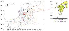
Fig. 1
The trajectories of 40 typhoons that occurred in the vicinity of Kyushu Island from 2019 to 2023, as well as the distribution of GNSS stations and automatic weather stations"
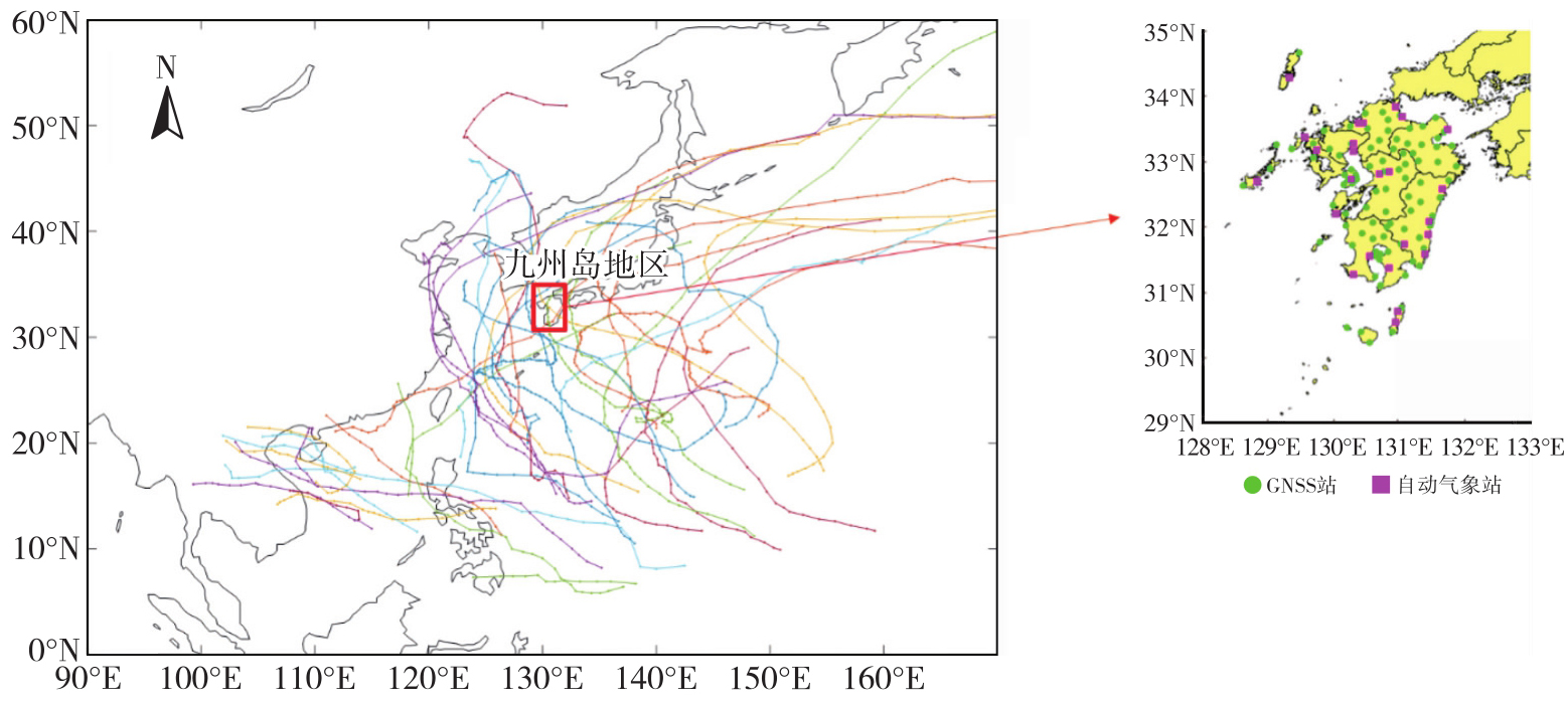
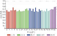
Fig. 2
The correlation coefficients between PWV and wind speed during 40 typhoon periods from 2019 to 2023"
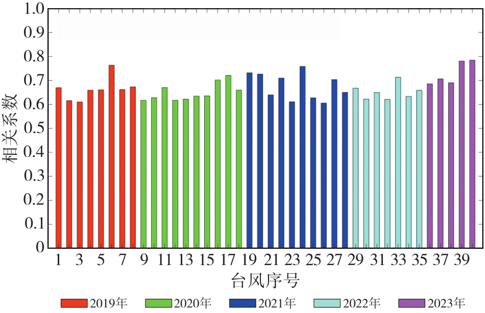
Fig. 3
Spatial distribution of the correlation coefficients between PWV and wind speed"
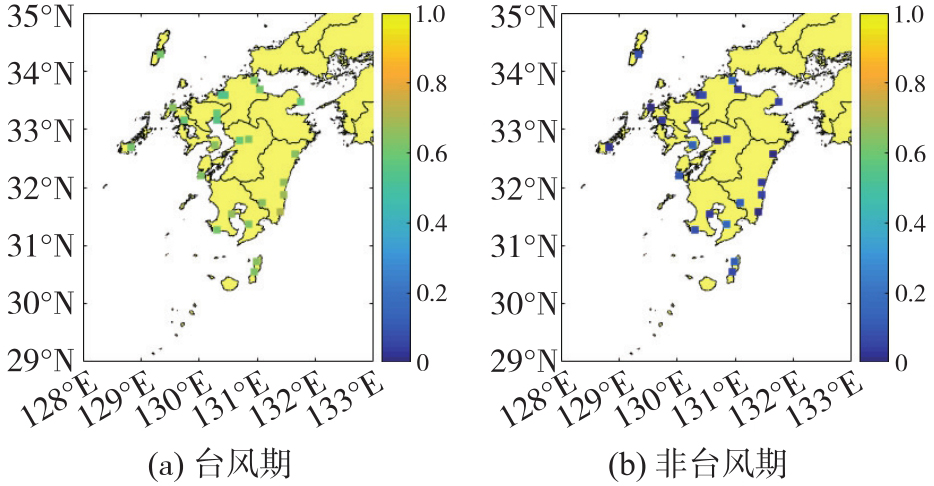
Fig. 4
Wind speed and wind level statistics of the PPWV-WS model with different polynomial orders"
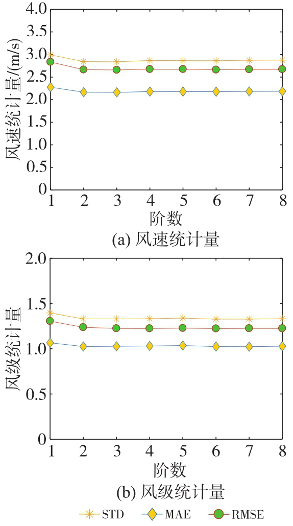
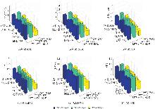
Fig. 5
Performances comparison of the LPWV-WS, PPWV-WS and PWV-WS3 models under five typhoon intensity levels"

Tab. 2
The comparison results of the three PWV-WS models in five types of typhoons"
| 模型 | 台风类型 | 地面风速/(m/s) | 风级 | ||||
|---|---|---|---|---|---|---|---|
| MAE | RMSE | STD | MAE | RMSE | STD | ||
| LPWV-WS | 热带风暴 | 1.82 | 2.41 | 2.13 | 0.88 | 1.19 | 1.08 |
| 强热带风暴 | 1.56 | 1.92 | 1.70 | 0.79 | 1.09 | 0.94 | |
| 台风 | 2.10 | 2.89 | 2.83 | 1.01 | 1.34 | 1.30 | |
| 强台风 | 1.95 | 2.58 | 2.41 | 0.92 | 1.24 | 1.16 | |
| 超强台风 | 2.50 | 3.21 | 3.04 | 1.15 | 1.48 | 1.37 | |
| PPWV-WS | 热带风暴 | 1.82 | 2.39 | 2.12 | 0.85 | 1.14 | 1.06 |
| 强热带风暴 | 1.54 | 1.91 | 1.69 | 0.76 | 0.99 | 0.93 | |
| 台风 | 1.98 | 2.75 | 2.71 | 0.93 | 1.25 | 1.23 | |
| 强台风 | 1.91 | 2.56 | 2.43 | 0.93 | 1.24 | 1.16 | |
| 超强台风 | 2.37 | 3.04 | 2.77 | 1.11 | 1.41 | 1.25 | |
| PWV-WS3 | 热带风暴 | 0.82 | 1.12 | 1.12 | 0.41 | 0.67 | 0.67 |
| 强热带风暴 | 0.75 | 1.00 | 0.99 | 0.38 | 0.63 | 0.63 | |
| 台风 | 0.91 | 1.29 | 1.29 | 0.45 | 0.72 | 0.72 | |
| 强台风 | 0.86 | 1.17 | 1.17 | 0.42 | 0.68 | 0.68 | |
| 超强台风 | 0.90 | 1.27 | 1.26 | 0.44 | 0.71 | 0.71 | |
Tab. 3
Comparison results of LPWV-WS, AR_LPWV-WS, PPWV-WS, AR_PPWV-WS, AR_WS, and PWV-WS3 models"
| 模型 | 地面风速/(m/s) | 风级 | ||||
|---|---|---|---|---|---|---|
| MAE | RMSE | STD | MAE | RMSE | STD | |
| LPWV-WS | 2.27 | 2.99 | 2.83 | 1.06 | 1.39 | 1.30 |
| AR_LPWV-WS | 1.34 | 1.37 | 1.36 | 0.66 | 0.83 | 0.82 |
| PPWV-WS | 2.16 | 2.83 | 2.65 | 1.02 | 1.32 | 1.31 |
| AR_PPWV-WS | 1.21 | 1.28 | 1.27 | 0.56 | 0.78 | 0.77 |
| AR_WS | 1.57 | 1.63 | 1.62 | 0.73 | 0.89 | 0.89 |
| PWV-WS3 | 0.89 | 1.25 | 1.24 | 0.44 | 0.71 | 0.70 |
Tab. 4
Results of significance tests for regression coefficients in the PWV-WS3 model"
| 变量 | 系数估计值 | t值 | p值 |
|---|---|---|---|
| WS(t-1) | 0.908 | 721.064 | <0.001 |
| PWV(t) | 0.059 | 31.317 | <0.001 |
| PWV(t-1) | -0.046 | -24.725 | <0.001 |
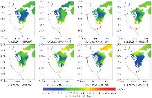
Fig. 6
Typhoon Khanun track and spatial distribution of surface wind speed based on automatic weather station data"

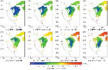
Fig. 7
Typhoon Khanun track and spatial distribution of surface wind speed based on GNSS-enhanced data"
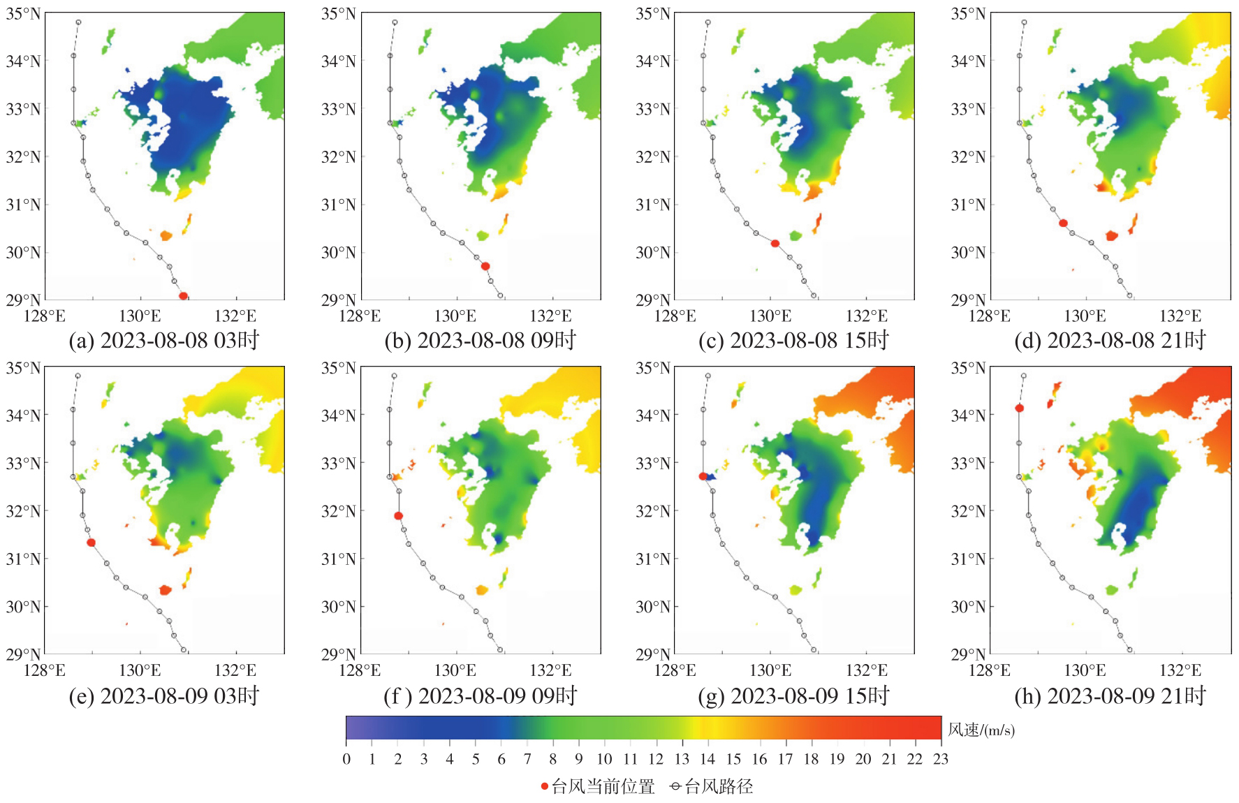
Tab. 5
Comparison of wind speed interpolation results before and after GNSS-PWV densification against ERA5 wind fields"
| 方案 | MAE | RMSE | STD |
|---|---|---|---|
| 无加密 | 3.42 | 3.95 | 3.78 |
| PWV加密 | 2.03 | 2.74 | 2.71 |
| [1] | 闵隽玉, 谈哲敏. 基于潜空间扩散模型的台风路径与强度预报模型研究[J]. 南京大学学报(自然科学), 2025, 61(3): 373-386. |
| Min Junyu, Tan Zhemin. On typhoon forecasting models for track and intensity based on latent diffusion model[J]. Journal of Nanjing University (Natural Science), 2025, 61(3): 373-386. | |
| [2] | 王充. 基于遥感图像和深度学习技术的台风信息提取和预报[D]. 青岛: 中国科学院大学(中国科学院海洋研究所), 2024. |
| Wang Chong. Typhoon information extraction and forecasting based on remote sensing images and deep learning technology[D]. Qingdao: Institute of Oceanology, Chinese Academy of Sciences, 2024. | |
| [3] | Pan Honglin, Yan Junjie, Kong Tuanjie, et al. Climatology of low-level aerosol extinction coefficient of different aerosol types and their association with the meteorology during 2007—2021: insights from the CALIPSO observation over China[J]. Theoretical and Applied Climatology, 2024, 156(1): 55. |
| [4] | 刘安琪, 窦芳丽, 刘可, 等. 基于多源数据和三重匹配方法的风云三号风场测量雷达海面风场精度分析[J]. 海洋气象学报, 2025, 45(3): 62-71. |
| Liu Anqi, Dou Fangli, Liu Ke, et al. Evaluation of FY-3E WindRAD sea surface wind field products based on multi-source data and triple collocation method[J]. Journal of Shandong Meteorology, 2025, 45(3): 62-71. | |
| [5] | 周鑫. 基于多普勒天气雷达的地面风场反演及大风预警方法研究[D]. 成都: 成都理工大学, 2020. |
| Zhou Xin. Study on wind field retrieval and gale warning near the surface based on Doppler weather radar[D]. Chengdu: Chengdu University of Technology, 2020. | |
| [6] | 梁旭东, 周海光, 罗义. 多普勒天气雷达反演风场综述[J]. 气象学报, 2025, 83(3): 855-872. |
| Liang Xudong, Zhou Haiguang, Luo Yi. Doppler radar wind field retrieval techniques: a review[J]. Acta Meteorologica Sinica, 2025, 83(3): 855-872. | |
| [7] | 曾加东, 宋子函, 张志田. 台风风特性现场实测与数值模拟研究综述[J]. 科学技术与工程, 2023, 23(28): 11937-11946. |
| Zeng Jiadong, Song Zihan, Zhang Zhitian. Review of field measurements and numerical simulations of typhoon wind characteristics[J]. Science Technology and Engineering, 2023, 23(28): 11937-11946. | |
| [8] | Xu Hongxiong, Zhao Yang, Zhao Dajun, et al. Exploring the typhoon intensity forecasting through integrating AI weather forecasting with regional numerical weather model[J]. npj Climate and Atmospheric Science, 2025, 8: 38. |
| [9] |
张克非, 李浩博, 王晓明, 等. 地基GNSS大气水汽探测遥感研究进展和展望[J]. 测绘学报, 2022, 51(7): 1172-1191. DOI: .
doi: 10.11947/j.AGCS.2022.20220149 |
|
Zhang Kefei, Li Haobo, Wang Xiaoming, et al. Recent progresses and future prospectives of ground-based GNSS water vapor soundina[J]. Acta Geodaetica et Cartographica Sinica, 2022, 51(7): 1172-1191. DOI: .
doi: 10.11947/j.AGCS.2022.20220149 |
|
| [10] |
姚宜斌, 赵庆志. GNSS对流层水汽监测研究进展与展望[J]. 测绘学报, 2022, 51(6): 935-952. DOI: .
doi: 10.11947/j.AGCS.2022.20220039 |
|
Yao Yibin, Zhao Qingzhi. Research progress and prospect of monitoring tropospheric water vapor by GNSS technique[J]. Acta Geodaetica et Cartographica Sinica, 2022, 51(6): 935-952. DOI: .
doi: 10.11947/j.AGCS.2022.20220039 |
|
| [11] | Won J, Kim D. Analysis of temporal and spatial variation of precipitable water vapor according to path of typhoon EWINIAR using GPS permanent stations[J]. Journal of Positioning, Navigation, and Timing, 2015, 4(2): 87-95. |
| [12] | He Qimin, Zhang Kefei, Wu Suqin, et al. An investigation of atmospheric temperature and pressure using an improved spatio-temporal Kriging model for sensing GNSS-derived precipitable water vapor[J]. Spatial Statistics, 2022, 51: 100664. |
| [13] |
何琦敏, 张克非, 李黎, 等. 基于PWV到达时间差估计台风运动状态的四参数模型[J]. 测绘学报, 2024, 53(11): 2125-2137. DOI: .
doi: 10.11947/j.AGCS.2024.20230473 |
|
He Qimin, Zhang Kefei, Li Li, et al. A four-parameter model for estimating typhoon motion states based on time difference of PWV arrival[J]. Acta Geodaetica et Cartographica Sinica, 2024, 53(11): 2125-2137. DOI: .
doi: 10.11947/j.AGCS.2024.20230473 |
|
| [14] | He Qimin, Zhang Kefei, Wu Suqin, et al. Real-time GNSS-derived PWV for typhoon characterizations: a case study for super typhoon Mangkhut in Hong Kong[J]. Remote Sensing, 2019, 12(1): 104. |
| [15] | Kang I, Park J. Use of GNSS-derived PWV for predicting the path of typhoon: case studies of Soulik and Kongrey in 2018[J]. Journal of Surveying Engineering, 2021, 147(4): 04021018. |
| [16] | He Qimin, Shen Zhen, Wan Moufeng, et al. Precipitable water vapor converted from GNSS-ZTD and ERA5 datasets for the monitoring of tropical cyclones[J]. IEEE Access, 2020, 8: 87275-87290. |
| [17] | Shi Jiaqi, Li Min, Steiner A K, et al. Evaluation of reanalysis precipitable water vapor under typhoon conditions using multi-source observations[J]. Atmospheric Chemistry and Physics, 2026, 26(7): 4633-4650. |
| [18] | Mei Xinyu, Xu Keke, Wang Xue. Monitoring water vapor variations during Super Typhoon Saola's impact on Hong Kong using GNSS observations[J]. Measurement Science and Technology, 2025, 36(8): 085801. |
| [19] | Chabibi F F, Putri N S E, Wijaya D D. Tropical cyclone intensity prediction using BP-RNN from GPS-derived precipitable water vapor and surface meteorological data[J]. IOP Conference Series: Earth and Environmental Science, 2024, 1418(1): 012020. |
| [20] | Dach R, Lutz S, Walser P, et al. Bernese GNSS software version 5.2[M]. Bern: Bern Open Publishing, 2015. |
| [21] | Herring TA, Floyd MA, Perry M, et al. Introduction to GAMIT/GLOBK[R]. Cambridge: Massachusetts Institute of Technology, 2010. |
| [22] | Saastamoinen J. Contributions to the theory of atmospheric refraction[J]. Bulletin Géodésique, 1972, 105(1): 279-298. |
| [23] | Landskron D, Böhm J. VMF3/GPT3: refined discrete and empirical troposphere mapping functions[J]. Journal of Geodesy, 2018, 92(4): 349-360. |
| [24] | Ding Junsheng, Chen Junping, Tang Wenjie, et al. Spatial-temporal variability of global GNSS-derived precipitable water vapor (1994-2020) and climate implications[J]. Remote Sensing, 2022, 14(14): 3493. |
| [25] | 马华锋, 李黎, 张志杰, 等. 基于GNSS、ERA5和机器学习的区域天顶对流层延迟校正和大气可降水量预测模型[J]. 地球物理学报, 2026, 69(1): 55-68. |
| Ma Huafeng, Li Li, Zhang Zhijie, et al. The Regional zenith tropospheric delay correction and precipitable water vapor prediction models based on the GNSS, ERA5 and machine learning[J]. Chinese Journal of Geophysics, 2026, 69(1): 55-68. | |
| [26] | Jiang Chunhua, Chen Shaoni, Gao Xiang, et al. A direct conversion model from ZTD to PWV based on the random forest[J]. Measurement Science and Technology, 2025, 36(2): 025802. |
| [27] | Li Junyu, Li Haojie, Liu Lilong, et al. An improved typhoon monitoring model based on precipitable water vapor and pressure[J]. Geodesy and Geodynamics, 2024, 15(3): 276-290. |
| [28] | 刘伟. 基于惯性/多普勒组合导航的风速风向测量研究[D]. 南京: 南京航空航天大学, 2011. |
| Liu Wei. Research on wind speed and direction measurement based on INS/Doppler integrated navigation[D]. Nanjing: Nanjing University of Aeronautics and Astronautics, 2011. | |
| [29] | 赵庆志. 地基GNSS水汽反演关键技术研究及其应用[D]. 武汉: 武汉大学, 2017. |
| Zhao Qingzhi. Studies on the key technologies in water vapor inversion using ground-based GNSS and its applications[D]. Wuhan: Wuhan University, 2017. | |
| [30] | Huler S. Defining the wind: the beaufort scale and how a 19th-century admiral turned science into poetry[M]. New York: Crown, 2005. |
| [31] | 逯智科, 徐万海, 王玮, 等. 台风极值风速预测研究综述[J]. 力学与实践, 2025, 47(5): 906-919. |
| Lu Zhike, Xu Wanhai, Wang Wei, et al. A review of research on prediction of typhoon extreme wind speeds[J]. Mechanics in Engineering, 2025, 47(5): 906-919. | |
| [32] | Zhang Yuxin, Cao Shuyang, Cao Jinxin. A framework for efficient simulation of urban strong wind field during typhoon process using coupled WRF-UCM and embedded LES model[J]. Journal of Wind Engineering and Industrial Aerodynamics, 2024, 250: 105757. |
| [33] | Zhao Lin, Cui Wei, Fang Genshen, et al. State-of-the-art review on typhoon wind environments and their effects on long-span bridges[J]. Advances in Wind Engineering, 2024, 1(1): 100007. |
| [1] | Fei Guo, Qinyu Guo, Guoji Hu, Xiaohong Zhang, Qi Tang. Rapid monitoring and analysis of sea surface wind fields and flooding processes associated with Typhoon Bavi (2026) based on multi-source GNSS-R observations [J]. Acta Geodaetica et Cartographica Sinica, 2026, 55(8): 1331-1342. |
| [2] | Hongmei WANG, Lihua WANG, Benhua TAN, Xiaoyi JIANG, Lili SONG, Weiwei SUN. SAR high-precision inversion of sea surface current over offshore China [J]. Acta Geodaetica et Cartographica Sinica, 2026, 55(4): 588-603. |
| [3] | Bo ZHU, Houpu LI, Libo ZHU, Shaofeng BIAN, Cheng CHEN. A regional geomagnetic field model for China based on Swarm satellite data and 3D Legendre polynomials [J]. Acta Geodaetica et Cartographica Sinica, 2025, 54(3): 461-472. |
| [4] | Shuren GUO, Hongliang CAI, Weiguang GAO, Wei ZHOU, Changjiang GENG, Gang LI, Ming DONG, Chengeng SU, Kun JIANG, Yinan MENG, Lei CHEN, Junyang PAN, Kai LI, Qifen LI, Xiaomei TANG, Shuangna ZHANG, Xiaogong HU. A novel architecture of global navigation satellite system for accurate and trusted PNT services [J]. Acta Geodaetica et Cartographica Sinica, 2025, 54(11): 1934-1953. |
| [5] | Hailu CHEN, Yunzhong SHEN. GNSS-assisted InSAR tropospheric delay correction model incorporating vertical stratification and turbulent components [J]. Acta Geodaetica et Cartographica Sinica, 2025, 54(10): 1786-1797. |
| [6] | Jinwei BU, Kegen YU, Qiulan WANG, Linghui LI, Xinyu LIU, Xiaoqing ZUO, Jun CHANG. Deep learning retrieval method for global ocean significant wave height by integrating spaceborne GNSS-R data and multivariable parameters [J]. Acta Geodaetica et Cartographica Sinica, 2024, 53(7): 1321-1335. |
| [7] | Chunhua JIANG, Xiang GAO, Shuaimin WANG, Huizhong ZHU, Shaoni CHEN, Guangsheng LIU. A global vertical correction model of PWV considering the spatial-temporal variation of decay coefficient [J]. Acta Geodaetica et Cartographica Sinica, 2024, 53(5): 889-899. |
| [8] | Qimin HE, Kefei ZHANG, Li LI, Dajun LIAN, Wei ZHAO, Guodong CHEN, Erjiang FU, Rui WANG. A four-parameter model for estimating typhoon motion states based on time difference of PWV arrival [J]. Acta Geodaetica et Cartographica Sinica, 2024, 53(11): 2125-2137. |
| [9] | XIE Shaofeng, WANG Yijie, HUANG Liangke, PENG Hua, LI Junyu, LIU Lilong. A grid model for the lapse rate of atmospheric weighted mean temperature over China [J]. Acta Geodaetica et Cartographica Sinica, 2023, 52(2): 206-217. |
| [10] | TAN Shusen, ZHANG Tianqiao. Progress and evolution of contemporary GNSS [J]. Acta Geodaetica et Cartographica Sinica, 2022, 51(7): 1114-1118. |
| [11] | YAO Yibin, ZHAO Qingzhi. Research progress and prospect of monitoring tropospheric water vapor by GNSS technique [J]. Acta Geodaetica et Cartographica Sinica, 2022, 51(6): 935-952. |
| [12] | WANG Hao, DING Nan, ZHANG Wenyuan, FENG Zunde, ZHAO Changsheng, YAN Xiangrong. An adaptive non-uniform vertical stratification for GNSS water vapor tomography [J]. Acta Geodaetica et Cartographica Sinica, 2022, 51(3): 327-339. |
| [13] | ZHAO Qingzhi, DU Zheng, YAO Wanqiang, YAO Yibin. The MERSI/FY-3A PWV correction method based on GNSS [J]. Acta Geodaetica et Cartographica Sinica, 2022, 51(2): 159-168. |
| [14] | YANG Fei, GUO Jiming, CHEN Ming, ZHANG Di. Establishment and analysis of a refinement method for the GNSS empirical weighted mean temperature model [J]. Acta Geodaetica et Cartographica Sinica, 2022, 51(11): 2339-2345. |
| [15] | YANG Jinling, CHEN Shi, WANG Linhai, LU Hongyan, LI Honglei, ZHANG Bei. Data quality assessment of time-varying terrestrial gravity observation in South China [J]. Acta Geodaetica et Cartographica Sinica, 2021, 50(3): 333-342. |
| Viewed | ||||||
|
Full text |
|
|||||
|
Abstract |
|
|||||
