

Acta Geodaetica et Cartographica Sinica ›› 2025, Vol. 54 ›› Issue (12): 2116-2128.doi: 10.11947/j.AGCS.2025.20250245
• Geodesy and Navigation • Previous Articles Next Articles
Bofeng LI( ), Long CHEN, Leitong YUAN
Received:2025-06-13
Revised:2025-12-25
Online:2026-01-15
Published:2026-01-15
About author:LI Bofeng (1983—), male, PhD, professor, majors in satellite geodesy. E-mail: bofeng_li@tongji.edu.cn
Supported by:CLC Number:
Bofeng LI, Long CHEN, Leitong YUAN. A high-precision deformation monitoring method with GNSS multi-baseline solutions[J]. Acta Geodaetica et Cartographica Sinica, 2025, 54(12): 2116-2128.
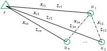
Fig. 1
Multi-baseline solutions"
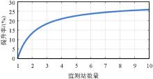
Fig. 2
Improvement of ambiguity float solutions precision varying with the number of monitoring stations"
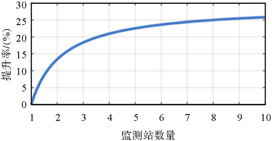
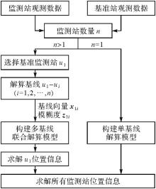
Fig. 3
Flow chart of GNSS multi-baseline solutions"

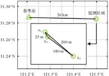
Fig. 4
Stations distribution of simulated monitoring experiment"
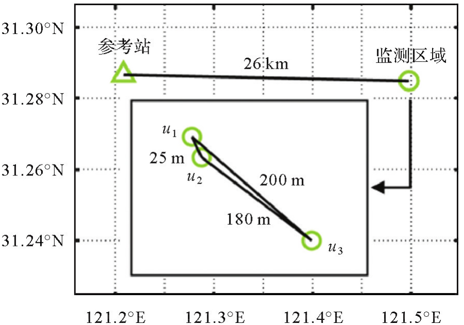
Fig. 5
Number of available satellites and PDOP in simulated monitoring experiment"


Fig. 6
Time serie of ADOP"
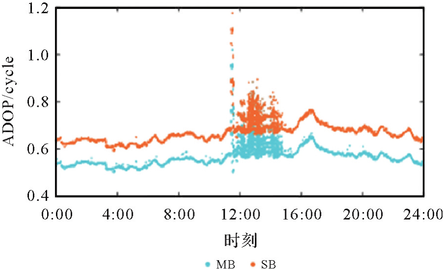

Fig. 7
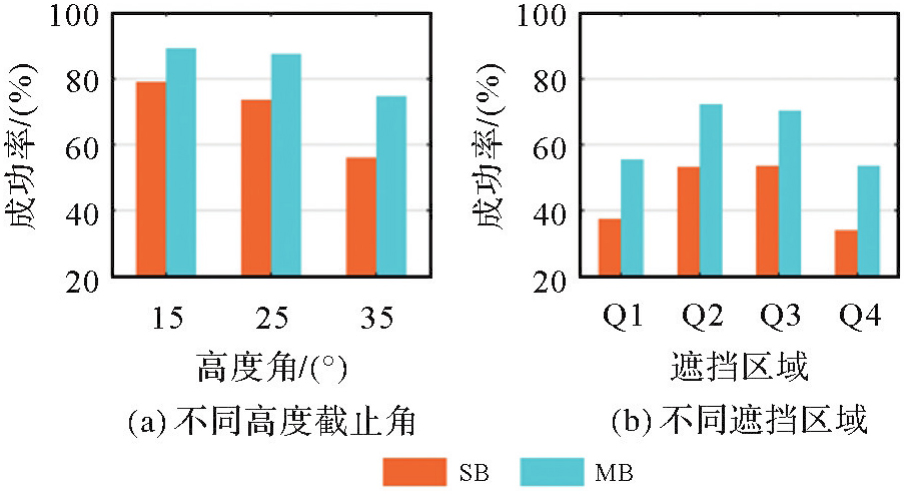
Mean Bootstrapping success rate"
Tab. 1
The statistics of monitoring accuracy of STD"
| 监测站 | 单/多基线解算 | 无遮挡 | Q1 | Q2 | Q3 | Q4 | ||||||||||
|---|---|---|---|---|---|---|---|---|---|---|---|---|---|---|---|---|
| E | N | U | E | N | U | E | N | U | E | N | U | E | N | U | ||
| u1 | SB | 0.8 | 0.6 | 2.7 | 1.0 | 0.7 | 2.6 | 0.8 | 0.7 | 2.7 | 0.8 | 0.9 | 2.6 | 1.0 | 0.7 | 3.3 |
| MB | 0.7 | 0.5 | 2.7 | 1.0 | 0.7 | 2.0 | 0.7 | 0.7 | 2.7 | 0.7 | 0.7 | 2.7 | 0.5 | 0.6 | 2.9 | |
| u2 | SB | 0.5 | 0.7 | 3.0 | 0.9 | 0.6 | 2.9 | 0.5 | 0.7 | 3.2 | 0.5 | 1.0 | 3.3 | 0.9 | 1.2 | 4.4 |
| MB | 0.5 | 0.7 | 3.1 | 1.2 | 0.7 | 3.1 | 0.5 | 0.8 | 2.9 | 0.5 | 1.0 | 3.1 | 0.7 | 1.5 | 3.8 | |
| u3 | SB | 1.0 | 0.8 | 3.9 | 3.3 | 1.1 | 4.1 | 1.2 | 1.3 | 4.1 | 1.3 | 1.4 | 4.0 | 1.4 | 0.7 | 6.7 |
| MB | 1.0 | 0.7 | 3.5 | 3.3 | 1.5 | 2.7 | 0.9 | 1.1 | 3.5 | 1.2 | 1.3 | 3.2 | 1.5 | 0.9 | 5.0 | |
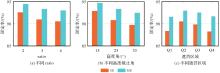
Fig. 8
Mean fix rate"

Tab. 2
Mean value of first type TTFF"
| 单/多基线解算 | 高度角 | 遮挡区域 | |||||
|---|---|---|---|---|---|---|---|
| 15° | 25° | 35° | Q1 | Q2 | Q3 | Q4 | |
| SB | 55.85 | 68.27 | 91.14 | 55.85 | 47.85 | 49.26 | 62.41 |
| MB | 22.75 | 23.67 | 37.68 | 46.07 | 37.98 | 38.71 | 50.14 |
Tab. 3
Mean value of second type TTFF"
| 单/多基线解算 | ratio | 高度角 | 遮挡区域 | |||||||
|---|---|---|---|---|---|---|---|---|---|---|
| 2 | 3 | 4 | 15° | 25° | 35° | Q1 | Q2 | Q3 | Q4 | |
| SB | 196.58 | 209.67 | 210.87 | 165.89 | 193.06 | 273.10 | 323.04 | 249.04 | 284.13 | 341.34 |
| MB | 143.31 | 156.65 | 158.97 | 117.26 | 147.88 | 208.39 | 242.16 | 193.04 | 217.48 | 244.58 |
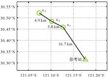
Fig. 9
Stations distribution of Hangzhou Bay Bridge monitoring experiment"
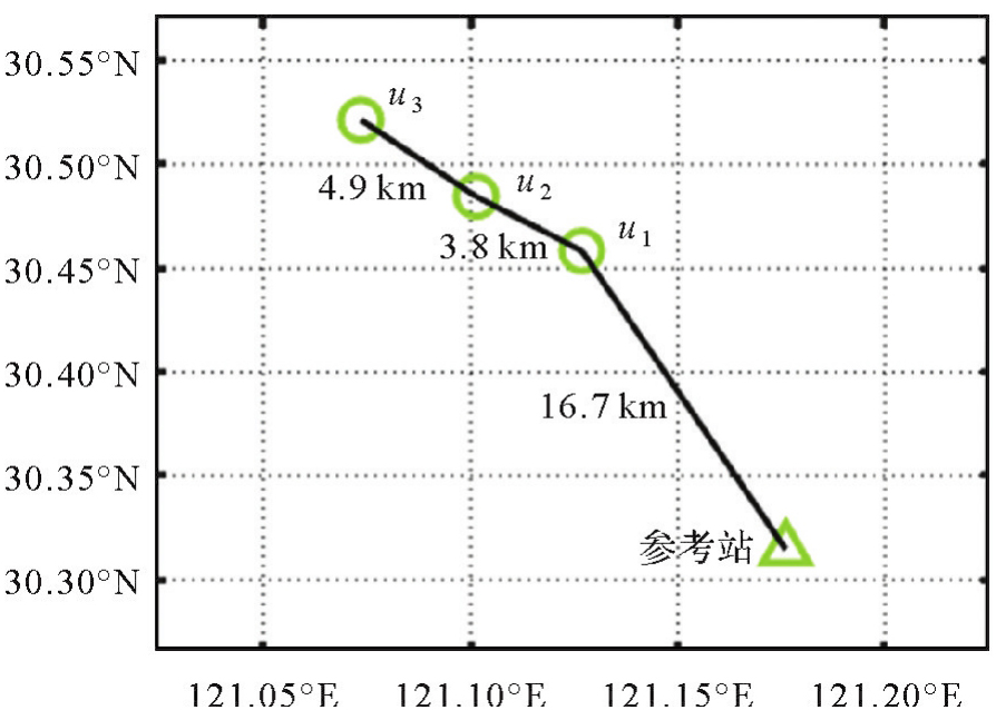
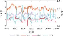
Fig. 10
Number of available satellites and PDOP in Hangzhou Bay bridge monitoring experiment"
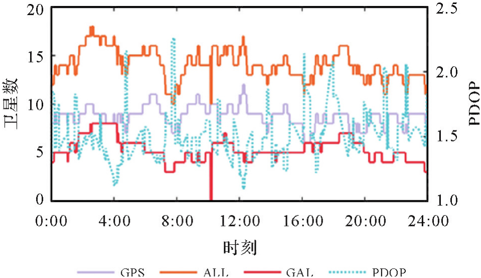
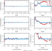
Fig. 11
u1 positioning error"
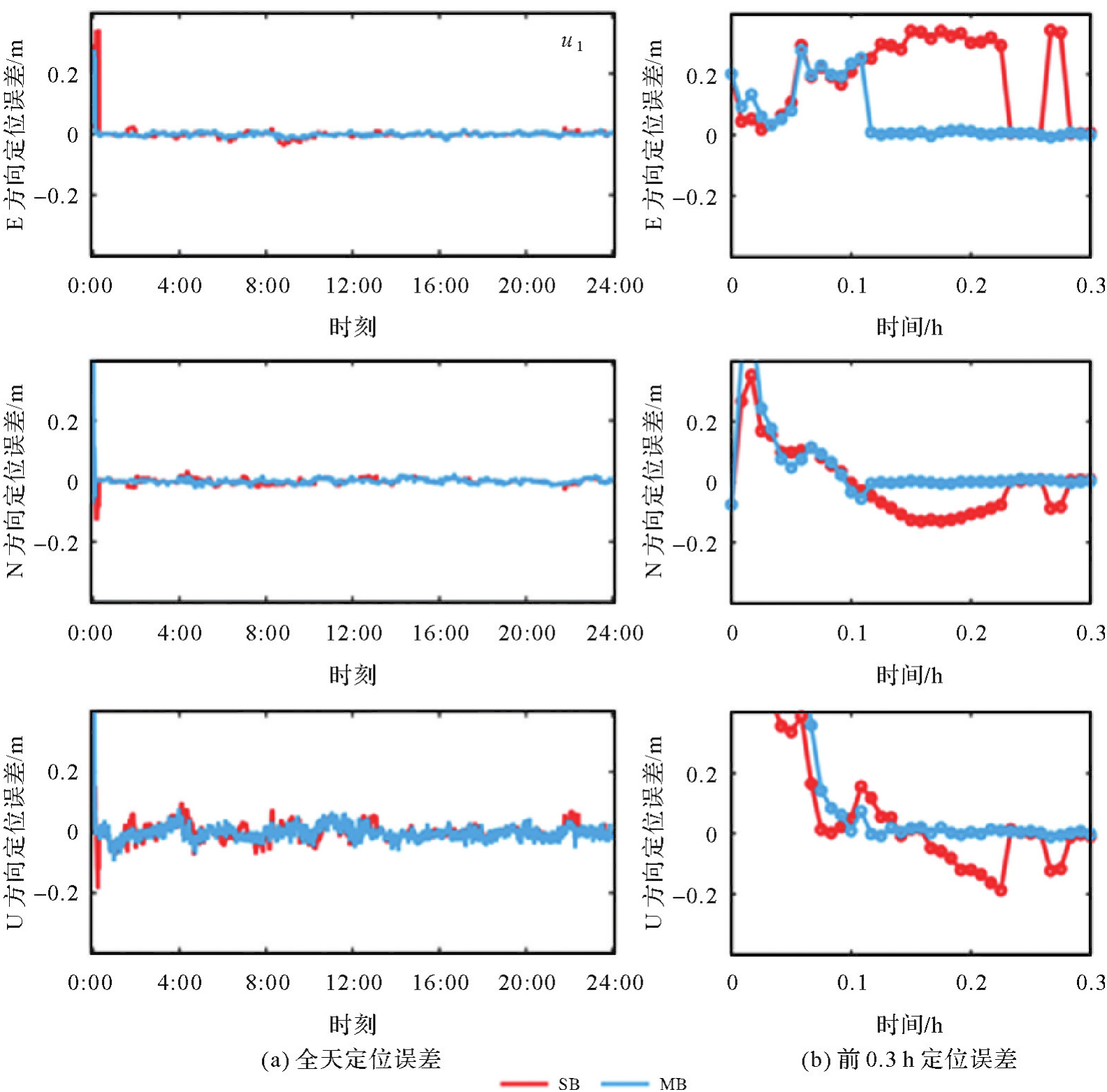
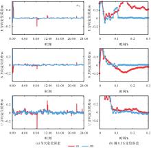
Fig. 12
u2 positioning error"

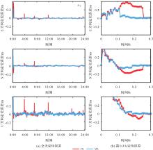
Fig. 13
u3 positioning error"

Tab. 4
Empirical success rate"
| 单/多基线解算 | u1 | u2 | u3 |
|---|---|---|---|
| SB | 94.6 | 96.8 | 93.9 |
| MB | 98.6 | 98.6 | 98.5 |
Tab. 5
The statistics of kinematic positioning errors"
| 监测站 | 单/多基线解算 | STD | ||
|---|---|---|---|---|
| E | N | U | ||
| u1 | SB | 0.81 | 0.88 | 2.47 |
| MB | 0.65 | 0.78 | 2.09 | |
| u2 | SB | 0.76 | 0.93 | 2.77 |
| MB | 0.63 | 0.75 | 2.32 | |
| u3 | SB | 0.77 | 0.83 | 2.47 |
| MB | 0.64 | 0.75 | 2.08 | |
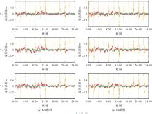
Fig. 14
Positioning error during reconvergence"
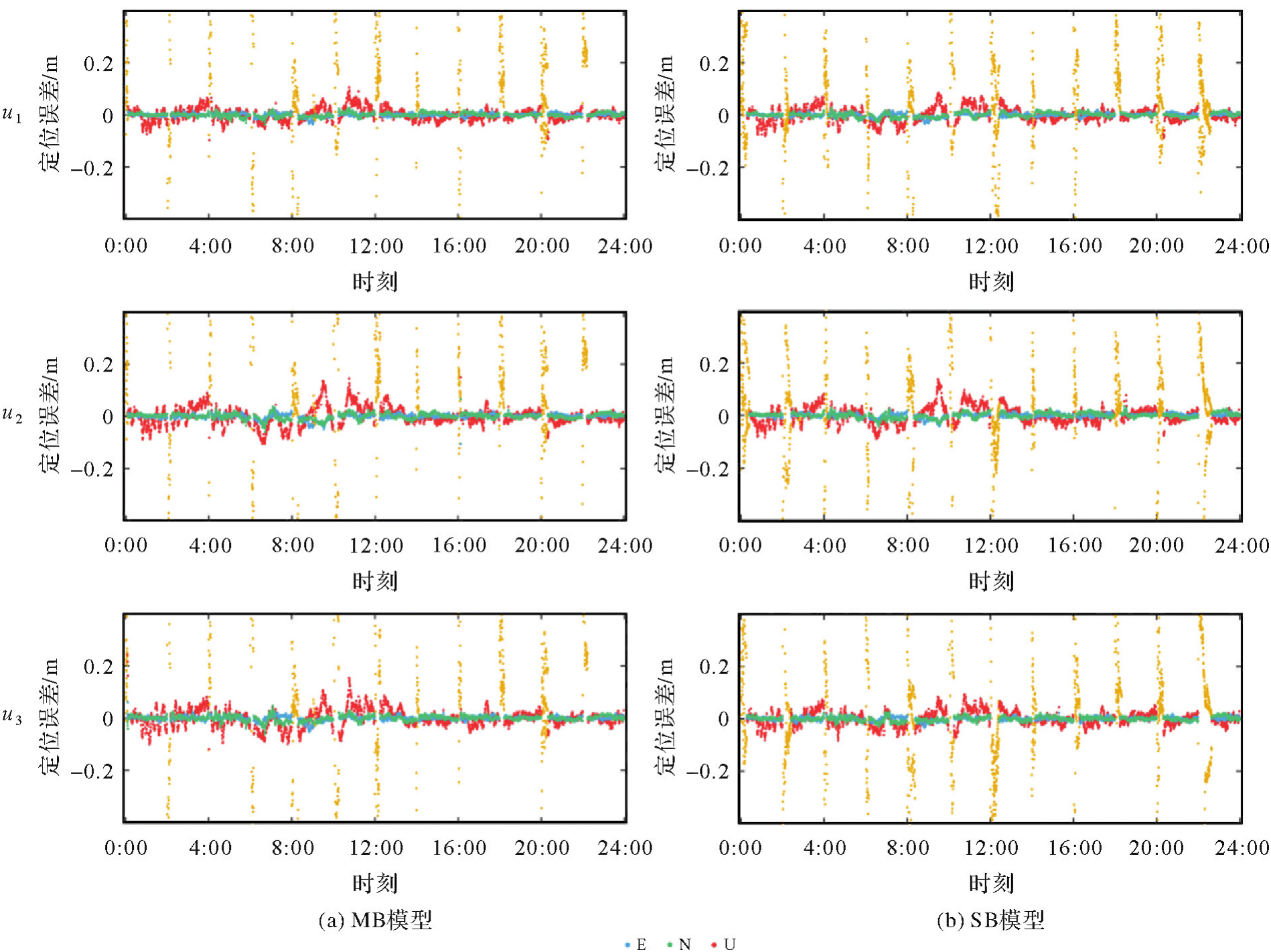
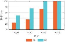
Fig. 15
Reconvergence time frequency statistics"

| [1] | HAN Junqiang, HUANG Guanwen, ZHANG Qin, et al. A new azimuth-dependent elevation weight (ADEW) model for real-time deformation monitoring in complex environment by multi-GNSS[J]. Sensors, 2018, 18(8): 2473-2488. |
| [2] | JIANG Weiping, CHEN Yan, CHEN Qusen, et al. High precision deformation monitoring with integrated GNSS and ground range observations in harsh environment[J]. Measurement, 2022, 204: 112179-112188. |
| [3] | GAO Rui, LIU Zhizhao, ODOLINSKI R, et al. Hong Kong-Zhuhai-Macao bridge deformation monitoring using PPP-RTK with multipath correction method[J]. GPS Solutions, 2023, 27(4): 195-209. |
| [4] | WANG Duo, HUANG Guanwen, DU Yuan, et al. Stability analysis of reference station and compensation for monitoring stations in GNSS landslide monitoring[J]. Satellite Navigation, 2023, 4(1): 29-43. |
| [5] |
黄观文, 陈孜, 徐永福. 膨胀土边坡GNSS实时监测技术[J]. 测绘学报, 2023, 52(11): 1873-1882. DOI: .
doi: 10.11947/j.AGCS.2023.20220562 |
|
HUANG Guanwen, CHEN Zi, XU Yongfu. GNSS real-time monitoring technology of expansive soil slope[J]. Acta Geodaetica et Cartographica Sinica, 2023, 52(11): 1873-1882. DOI: .
doi: 10.11947/j.AGCS.2023.20220562 |
|
| [6] |
白正伟, 张勤, 黄观文, 等. “轻终端+行业云”的实时北斗滑坡监测技术[J]. 测绘学报, 2019, 48(11): 1424-1429. DOI: .
doi: 10.11947/j.AGCS.2019.20190167 |
|
BAI Zhengwei, ZHANG Qin, HUANG Guanwen, et al. Real-time BeiDou landslide monitoring technology of “light terminal plus industry cloud”[J]. Acta Geodaetica et Cartographica Sinica, 2019, 48(11): 1424-1429. DOI: .
doi: 10.11947/j.AGCS.2019.20190167 |
|
| [7] | SHI Junbo, HUANG Yongshuai, OUYANG Chenhao. A GPS relative positioning quality control algorithm considering both code and phase observation errors[J]. Journal of Geodesy, 2019, 93(9): 1419-1433. |
| [8] | 李海洋. 复杂环境下BDS/GNSS桥梁变形监测算法的研究与应用分析[D]. 武汉: 武汉大学, 2022. |
| LI Haiyang. Research and application analysis of BDS/GNSS bridge deformation monitoring algorithm in complex environment[D]. Wuhan: Wuhan University, 2022. | |
| [9] | XUE Chenyu, PSIMOULIS P A, MENG Xiaolin. Feasibility analysis of the performance of low-cost GNSS receivers in monitoring dynamic motion[J]. Measurement, 2022, 202: 111819-111834. |
| [10] | 栗广才. 大众智能手机GNSS模糊度固定理论与方法[D]. 武汉: 武汉大学, 2021. |
| LI Guangcai. Theory and method of GNSS ambiguity resolution for smartphones[D]. Wuhan: Wuhan University, 2021. | |
| [11] | LI Haiyang, NIE Guigen, CHEN Dezhong, et al. Constrained MLAMBDA method for multi-GNSS structural health monitoring[J]. Sensors, 2019, 19(20): 4462-4472. |
| [12] | 戴吾蛟. GPS精密动态变形监测的数据处理理论与方法研究[D]. 长沙: 中南大学, 2007. |
| DAI Wujiao. A study of data processing for precise dynamic deformation monitoring using GPS[D]. Changsha: Central South University, 2007. | |
| [13] | HOU Cheng, SHI Junbo, OUYANG Chenhao, et al. A dual-base station constraint method to improve deformation monitoring precision consistency in strip regions[J]. Satellite Navigation, 2024, 5(1): 26-40. |
| [14] | JING Ce, HUANG Guanwen, ZHANG Qin, et al. GNSS/accelerometer adaptive coupled landslide deformation monitoring technology[J]. Remote Sensing, 2022, 14(15): 3537-3557. |
| [15] | SUN Ao, ZHANG Qiuzhao, YU Zhangjun, et al. A novel slow-growing gross error detection method for GNSS/accelerometer integrated deformation monitoring based on state domain consistency theory[J]. Remote Sensing, 2022, 14(19): 4758-4775. |
| [16] | JIANG Chen, ZHANG Shubi, CAO Yizhi, et al. A robust fault detection algorithm for the GNSS/INS integrated navigation systems[J]. Journal of Geodesy and Geoinformation Science, 2020, 3(1): 12-24. |
| [17] | HUANG Guanwen, DU Shi, WANG Duo. GNSS techniques for real-time monitoring of landslides: a review[J]. Satellite Navigation, 2023, 4(1): 5-14. |
| [18] | BIAN Hefang, ZHANG Shubi, ZHANG Qiuzhao, et al. Monitoring large-area mining subsidence by GNSS based on IGS stations[J]. Transactions of Nonferrous Metals Society of China, 2014, 24(2): 514-519. |
| [19] | WANG Haonan, DAI Wujiao, YU Wenkun. BDS/GPS multi-baseline relative positioning for deformation monitoring[J]. Remote Sensing, 2022, 14(16): 3884-3898. |
| [20] | LU L, LIU W, ZHANG X. An effective QR-based reduction algorithm for the fast estimation of GNSS high-dimensional ambiguity resolution[J]. Survey Review, 2018, 50(358): 57-68. |
| [21] | LI Bofeng, SHEN Yunzhong, FENG Yanming, et al. GNSS ambiguity resolution with controllable failure rate for long baseline network RTK[J]. Journal of Geodesy, 2014, 88(2): 99-112. |
| [22] | LI Bofeng, QIN Yanan, LIU Tianxia. Geometry-based cycle slip and data gap repair for multi-GNSS and multi-frequency observations[J]. Journal of Geodesy, 2019, 93(3): 399-417. |
| [23] |
崔阳, 吕志平, 李林阳, 等. GNSS大网双差模型并行快速解算方法[J]. 测绘学报, 2017, 46(7): 848-856. DOI: .
doi: 10.11947/j.AGCS.2017.20160585 |
|
CUI Yang, LÜ Zhiping, LI Linyang, et al. A fast parallel processing strategy of double difference model for GNSS huge networks[J]. Acta Geodaetica et Cartographica Sinica, 2017, 46(7): 848-856. DOI: .
doi: 10.11947/j.AGCS.2017.20160585 |
|
| [24] | TEUNISSEN P J G. A canonical theory for short GPS baselines. Part I: the baseline precision[J]. Journal of Geodesy, 1997, 71(6): 320-336. |
| [25] | VERHAGEN S, LI Bofeng, TEUNISSEN P J G. Ps-LAMBDA: ambiguity success rate evaluation software for interferometric applications[J]. Computers & Geosciences, 2013, 54: 361-376. |
| [26] | TEUNISSEN P J G. Success probability of integer GPS ambiguity rounding and bootstrapping[J]. Journal of Geodesy, 1998, 72(10): 606-612. |
| [27] | 姜卫平, 刘鸿飞, 刘万科, 等. 西龙池上水库GPS变形监测系统研究及实现[J]. 武汉大学学报(信息科学版), 2012, 37(8): 949-952, 1009. |
| JIANG Weiping, LIU Hongfei, LIU Wanke, et al. CORS development for xilongchi dam deformation monitoring[J]. Geomatics and Information Science of Wuhan University, 2012, 37(8): 949-952, 1009. | |
| [28] | LI Bofeng, TEUNISSEN P J G. GNSS antenna array-aided CORS ambiguity resolution[J]. Journal of Geodesy, 2014, 88(4): 363-376. |
| [29] | TEUNISSEN P J G, MONTENBRUCK O. Springer handbook of global navigation satellite systems[M]. Berlin: Springer, 2017. |
| [30] | WANG Xinpeng, ZHAO Qingzhi, XI Ruijie, et al. Review of bridge structural health monitoring based on GNSS: from displacement monitoring to dynamic characteristic identification[J]. IEEE Access, 2021, 9: 80043-80065. |
| [31] | XI Ruijie, JIANG Weiping, XUAN Wei, et al. Performance assessment of structural monitoring of a dedicated high-speed railway bridge using a moving-base RTK-GNSS method[J]. Remote Sensing, 2023, 15(12): 3132-3149. |
| [1] | Ertao GAO, Jing LIU, Shujin LI, Guoqing ZHOU, Bolin FU, Shuxian LI. Multi-dimensional spatiotemporal monitoring and analysis of tidal flats in the Maowei Sea using integrated optical remote sensing and SAR [J]. Acta Geodaetica et Cartographica Sinica, 2026, 55(4): 632-646. |
| [2] | Jinwei BU, Shuhui LIU, Shunshuang XU, Tongsu XIANG, Qiulan WANG, Chaoying JI, Xiaoqing ZUO. Construction of an empirical model for estimating the global wave period of spaceborne GNSS-R [J]. Acta Geodaetica et Cartographica Sinica, 2026, 55(4): 684-697. |
| [3] | Tangting WU, Xinyu LUO, Liguo LU, Zhanke LIU, Nengfang CHAO. Assessment of water resource changes and drought characteristics in the Shaanxi, Gansu and Ningxia region based on GNSS and GRACE/GRACE-FO [J]. Acta Geodaetica et Cartographica Sinica, 2026, 55(3): 439-450. |
| [4] | Zhongmin MA, Shuangcheng ZHANG, Xin ZHOU, Qi LIU, Ning LIU, Hengli WANG. A flood monitoring method using FY-3 GNSS-R accounting for surface reflectivity uncertainty: a case study of the August 2 Guangdong rainstorm disaster [J]. Acta Geodaetica et Cartographica Sinica, 2026, 55(3): 451-464. |
| [5] | Qingyun YAN, Zixuan GUO, Yuanjin PAN, Yan JIA, Shuanggen JIN. Quantitative driving factors and zoning patterns of GNSS-R land surface reflectivity spatial heterogeneity [J]. Acta Geodaetica et Cartographica Sinica, 2026, 55(2): 315-327. |
| [6] | Qingzhi ZHAO, Duoduo JIANG, Yibin YAO, Zhi MA, Yongjie MA, Haojie LI, Ruirui XUE. An adaptive method for selecting the optimal GNSS satellite signal for water vapor tomography [J]. Acta Geodaetica et Cartographica Sinica, 2026, 55(1): 25-35. |
| [7] | Deying YU, Houpu LI, Yi LIU, Shuguang WU, Deyan LI, Mingchao LI, Wenkui LI, Shaofeng BIAN. A DBSCAN-based RAIM algorithm for multiple gross error identification [J]. Acta Geodaetica et Cartographica Sinica, 2026, 55(1): 59-72. |
| [8] | Dongliang CHENG, Lingqiu CHEN, Zhiyong HUANG, Shubo QIAO, Dandan WANG, Yaming YAN. Performance evaluation of COATS-based multi-mode and multi-frequency iGNSS-R altimetry [J]. Acta Geodaetica et Cartographica Sinica, 2026, 55(1): 73-89. |
| [9] | Zhonghe LIU, Zongchun LI, Hua HE, Yinggang GUO, Wenbin ZHAO. A strategy for selecting quasi-stable points with a high breakdown point by integrating robust S-transform with K-means clustering [J]. Acta Geodaetica et Cartographica Sinica, 2025, 54(9): 1608-1619. |
| [10] | Yarong LUO, Wentao LU, Chi GUO, Jingnan LIU. Left-handed symmetry equivariant filtering model and algorithm for GNSS/INS integrated navigation [J]. Acta Geodaetica et Cartographica Sinica, 2025, 54(8): 1389-1403. |
| [11] | Yangyi CHEN, Kai ZHENG, Xiaohong ZHANG, Mingkui WU, Pengxu WANG, Wenju FU, Kezhong LIU. GPS/Galileo/BDS overlapping frequencies multipath error analysis and modeling [J]. Acta Geodaetica et Cartographica Sinica, 2025, 54(8): 1427-1438. |
| [12] | Jianzhang LI, Haowen YAN, Weifang YANG, Xiaoning SU. GNSS pseudo trigonometric leveling method [J]. Acta Geodaetica et Cartographica Sinica, 2025, 54(7): 1170-1177. |
| [13] | Qingzhi ZHAO, Lulu CHANG, Yibin YAO, Haojie LI. A method for constructing a hydrological drought index integrated with GNSS and meteorological data [J]. Acta Geodaetica et Cartographica Sinica, 2025, 54(7): 1192-1205. |
| [14] | Qianxin WANG, Chao HU, Tong CHENG. A method for satellite ultra-rapid orbit and clock offset estimation based on the prior information of the GNSS clock parameters [J]. Acta Geodaetica et Cartographica Sinica, 2025, 54(6): 982-994. |
| [15] | Yang SHEN, Guangyun LI, Mingjian CHEN, Linyang LI, Xingyu SHI, Wei CAI, Weifeng HAO. Assessment of GNSS ionosphere models based on FY-3 TEC in polar regions [J]. Acta Geodaetica et Cartographica Sinica, 2025, 54(6): 995-1008. |
| Viewed | ||||||
|
Full text |
|
|||||
|
Abstract |
|
|||||