

Acta Geodaetica et Cartographica Sinica ›› 2026, Vol. 55 ›› Issue (3): 415-424.doi: 10.11947/j.AGCS.2026.20250350
• New Theories and Methods of Cartography in the Digital and Intelligent Era • Previous Articles Next Articles
Wenhao YU1,2( ), Ziyi ZENG1(), Yifan ZHANG1,3, Haizhong QIAN4
Received:2025-09-01
Revised:2026-03-02
Online:2026-04-16
Published:2026-04-16
Contact:
Ziyi ZENG
E-mail:yuwh@cug.edu.cn;zen@cug.edu.cn
About author:YU Wenhao (1987—), male, PhD, professor, majors in large models, map intelligence and spatio-temporal data mining. E-mail: yuwh@cug.edu.cn
Supported by:CLC Number:
Wenhao YU, Ziyi ZENG, Yifan ZHANG, Haizhong QIAN. Road network grid pattern analysis using a pre-trained model fusing spatial and topological information[J]. Acta Geodaetica et Cartographica Sinica, 2026, 55(3): 415-424.
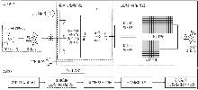
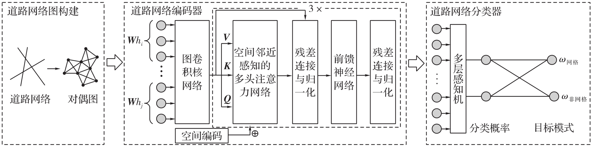
Fig. 1
Road network pattern recognition framework based on self-supervised graph learning model"
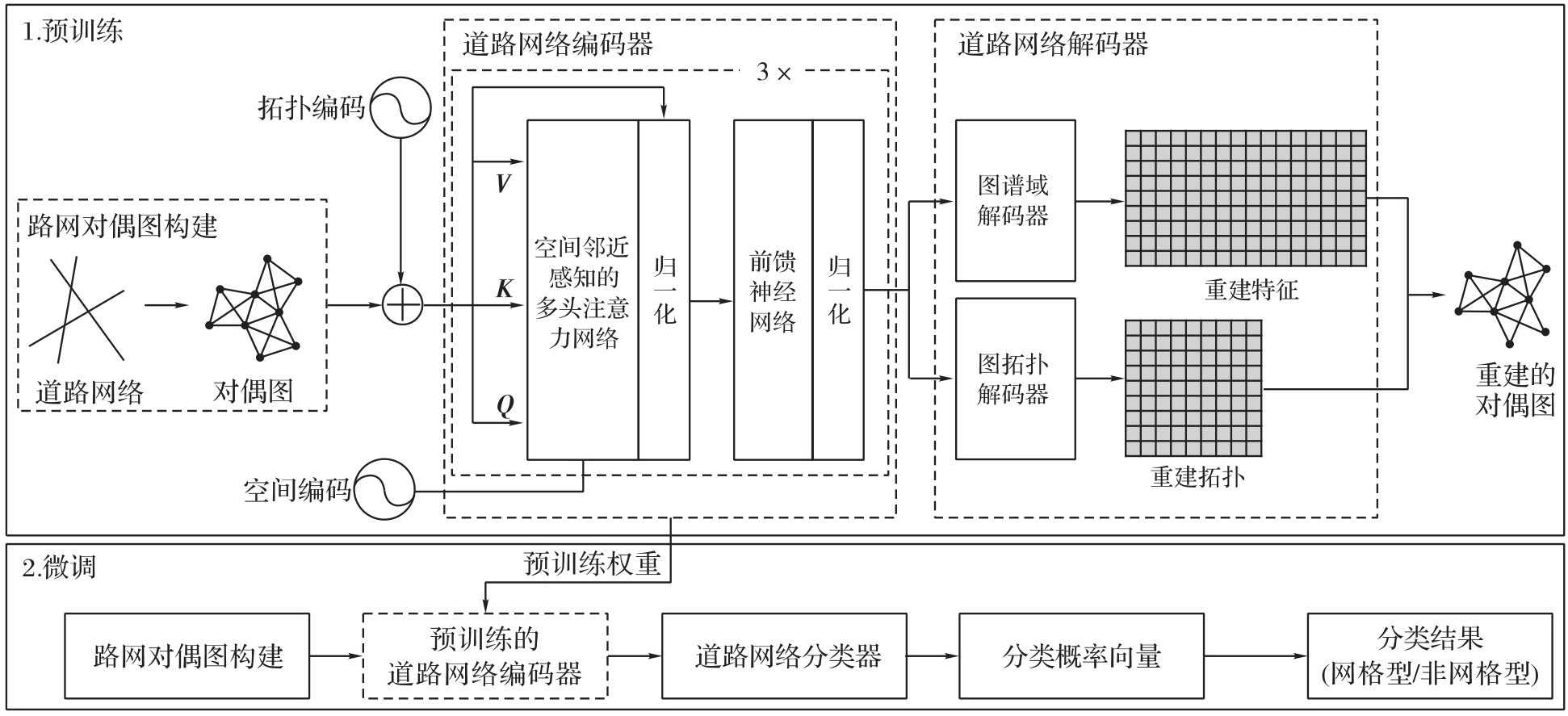
Fig. 2
Topological space adjacency encoding"
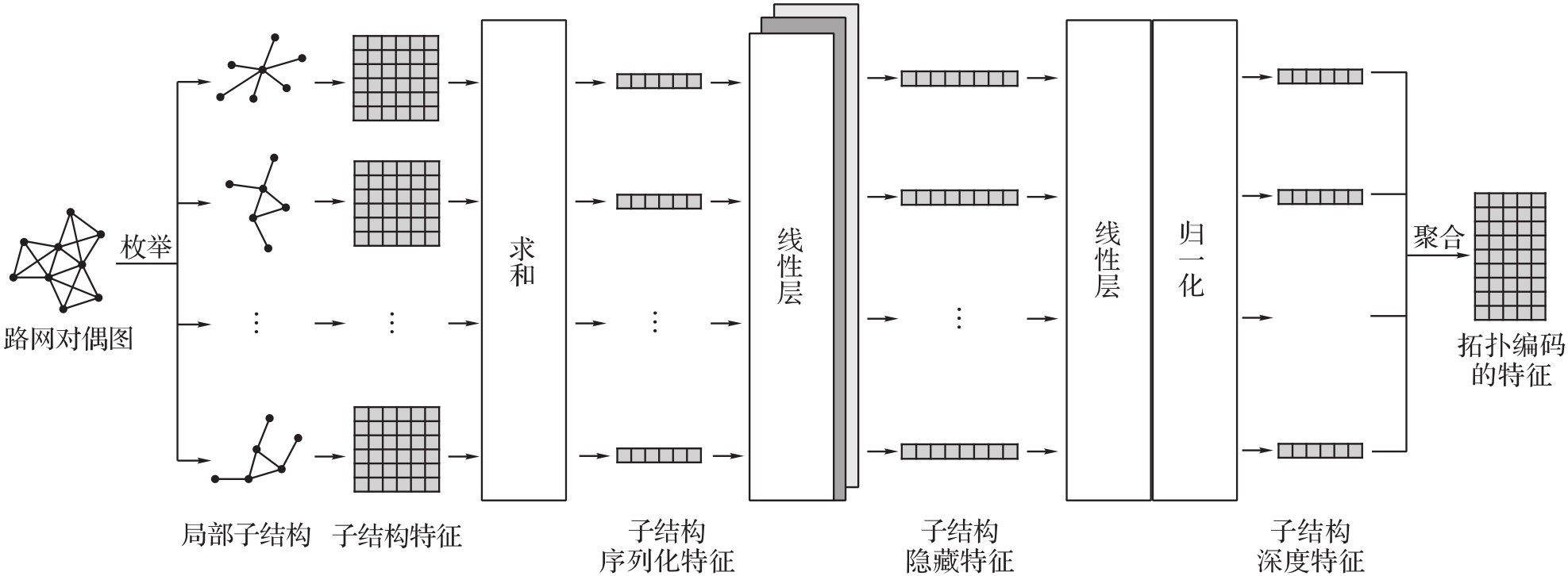
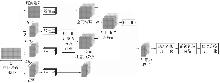
Fig. 3
Euclidean space proximity encoding"
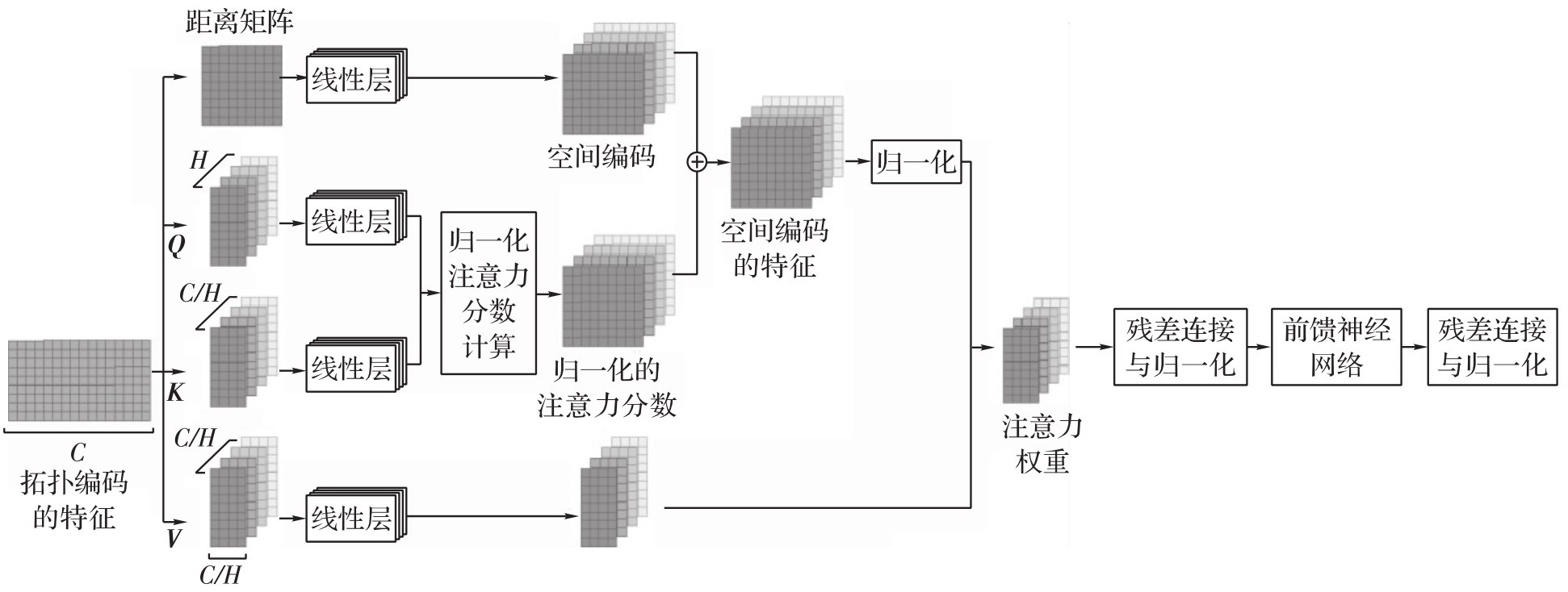
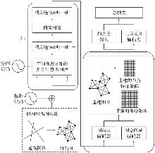
Fig. 4
The flowchart of the pre-training process"
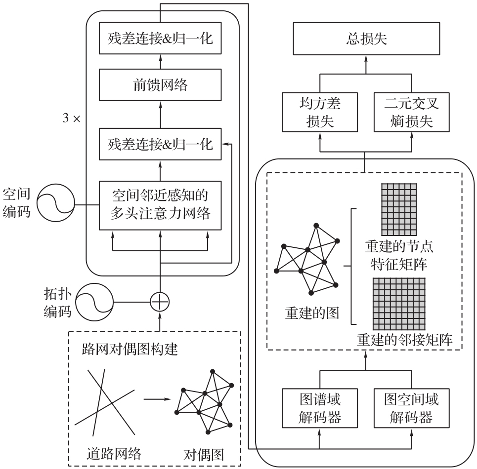
Fig. 5
The flowchart of the fine-tuning"
Tab. 1
Statistics of annotated road network dataset"
| 路网结构 | 微调数据集 | 测试数据集 | 合计 |
|---|---|---|---|
| 网格型 | 2702 | 676 | 3378 |
| 非网格型 | 4016 | 1063 | 5079 |
| 合计 | 6718 | 1739 | — |
Tab. 2
Comparison of performance metrics among different methods"
| 方法 | 准确率/(%) | 精确率/(%) | 召回率/(%) | F1值 |
|---|---|---|---|---|
| CRHD | 85.74 | 85.70 | 85.90 | 0.857 1 |
| SECA | 53.08 | 51.46 | 51.06 | 0.483 3 |
| K-means | 71.30 | 71.34 | 71.47 | 0.712 7 |
| GMM | 49.63 | 50.97 | 50.87 | 0.488 4 |
| SVM | 67.28 | 67.13 | 66.72 | 0.667 7 |
| 本文模型 | 88.03 | 88.89 | 87.47 | 0.878 0 |
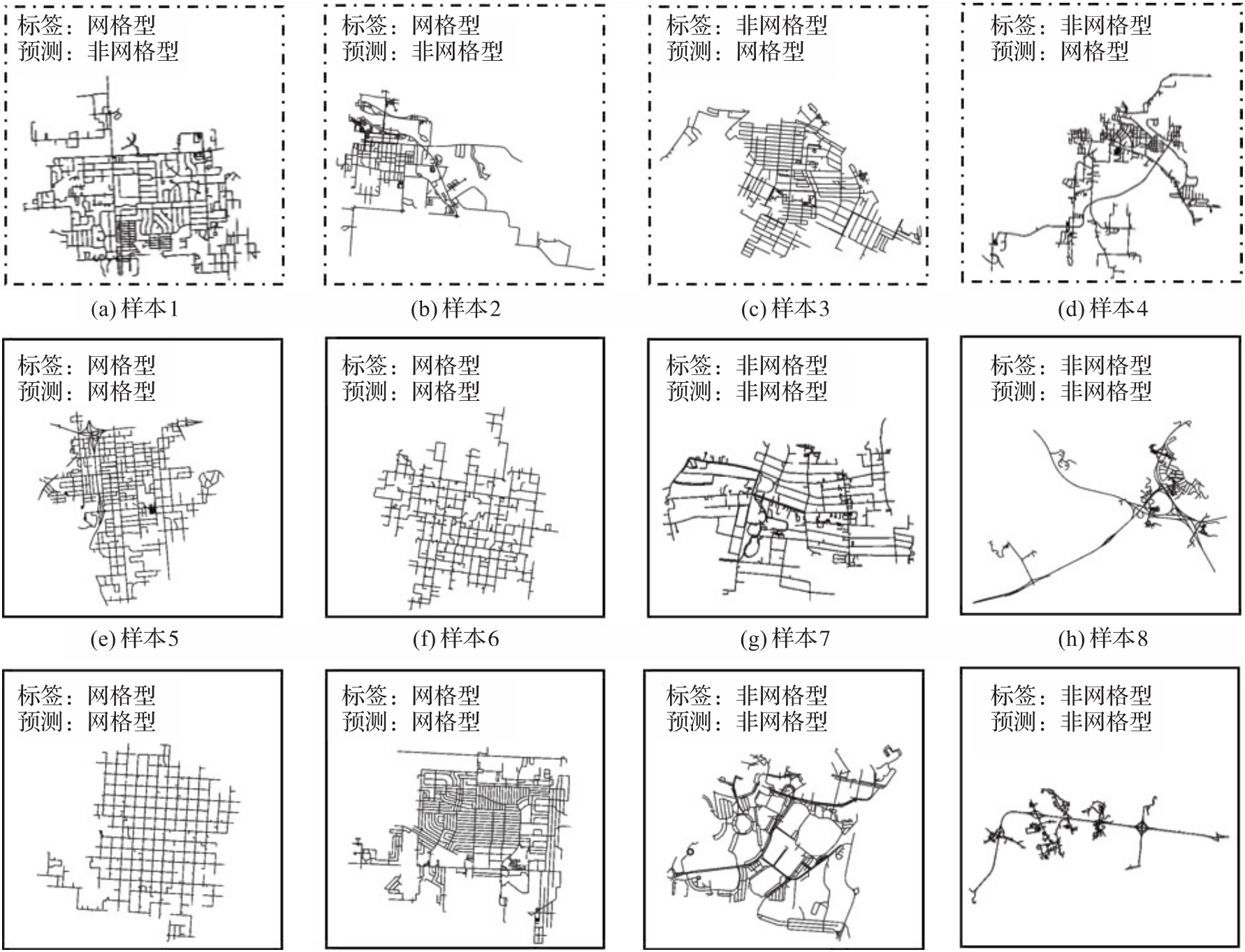
Fig. 6
Classification results of some samples"
Tab. 3
Comparison of performance metrics among methods with different training strategies and encodings"
| 方法 | 是否预训练 | 拓扑编码 | 空间编码 | 准确率/(%) | 精确率/(%) | 召回率/(%) | F1值 |
|---|---|---|---|---|---|---|---|
| 无预训练方法 | 否 | 否 | 否 | 66.76 | 74.59 | 68.75 | 0.652 7 |
| 预训练方法 | 是 | 否 | 否 | 80.68 | 82.63 | 81.60 | 0.806 1 |
| 拓扑编码方法 | 是 | 是 | 否 | 81.31 | 83.73 | 80.22 | 0.805 0 |
| 空间编码方法 | 是 | 否 | 是 | 81.77 | 82.75 | 81.03 | 0.813 0 |
| 本文模型 | 是 | 是 | 是 | 88.03 | 88.89 | 87.47 | 0.878 0 |
| [1] | 胡胜, 王振华, 邢汉发, 等. 中国城市路网形态与交通碳排放关系及影响机制研究[J]. 地球信息科学学报, 2025, 27(7): 1687-1703. |
| HU Sheng, WANG Zhenhua, XING Hanfa, et al. Relationship and impact mechanisms between urban road-network form and transport carbon emissions in China[J]. Journal of Geo-Information Science, 2025, 27(7): 1687-1703. | |
| [2] |
王安东, 武芳, 巩现勇, 等. 一种城市路网多层次复合网格模式识别方法[J]. 测绘学报, 2023, 52(11): 1994-2006. DOI: .
doi: 10.11947/j.AGCS.2023.20220528 |
|
WANG Andong, WU Fang, GONG Xianyong, et al. A recognition approach for compound grid pattern of urban road networks[J]. Acta Geodaetica et Cartographica Sinica, 2023, 52(11): 1994-2006. DOI: .
doi: 10.11947/j.AGCS.2023.20220528 |
|
| [3] | 吴小芳, 杜清运, 徐智勇. 多层次移位原则的道路与建筑物空间冲突处理[J]. 测绘学报, 2010, 39(6): 649-654. |
| WU Xiaofang, DU Qingyun, XU Zhiyong. Disposal of spatial conflict between roads and buildings based on the multilevel displacement principles[J]. Acta Geodaetica et Cartographica Sinica, 2010, 39(6): 649-654. | |
| [4] |
苏世亮, 向娟, 杜清运, 等. 叙事地图学的概念框架构建[J]. 测绘学报, 2025, 54(8): 1371-1388. DOI: .
doi: 10.11947/j.AGCS.2025.20250107 |
|
SU Shiliang, XIANG Juan, DU Qingyun, et al. Re-conceptualizing narrative cartography[J]. Acta Geodaetica et Cartographica Sinica, 2025, 54(8): 1371-1388. DOI: .
doi: 10.11947/j.AGCS.2025.20250107 |
|
| [5] | BENGUIGUI L, DAOUD M. Is the suburban railway system a fractal?[J]. Geographical Analysis, 1991, 23(4): 362-368. |
| [6] | 杜清运, 况路路, 任福, 等. 自动驾驶高精度地图特征分析及发展展望[J]. 地球信息科学学报, 2024, 26(1): 15-24. |
| DU Qingyun, KUANG Lulu, REN Fu, et al. Feature analysis and development prospect of high definition maps for autonomous driving[J]. Journal of Geo-Information Science, 2024, 26(1): 15-24. | |
| [7] | LÜ Zheng, SUN Qun, MA Jingzhen, et al. Road network generalization method constrained by residential areas[J]. ISPRS International Journal of Geo-Information, 2022, 11(3): 159. |
| [8] | BARTHÉLEMY M. Spatial networks[J]. Physics Reports, 2011, 499(1): 1-101. |
| [9] | YEH A G O, ZHONG T, YUE Y. Hierarchical polygonization for generating and updating lane-based road network information for navigation from road markings[J]. International Journal of Geographical Information Science, 2015, 29(9): 1509-1533. |
| [10] | CRUCITTI P, LATORA V, PORTA S. Centrality measures in spatial networks of urban streets[J]. Physical Review E, 2006, 73(3): 036125. |
| [11] | 田晶, 艾廷华, 丁绍军. 基于C4.5算法的道路网网格模式识别[J]. 测绘学报, 2012, 41(1): 121-126. |
| TIAN Jing, AI Tinghua, DING Shaojun. Grid pattern recognition in road networks based on C4.5 algorithm[J]. Acta Geodaetica et Cartographica Sinica, 2012, 41(1): 121-126. | |
| [12] | 何亚坤, 艾廷华, 杜欣, 等. 网络空间向量剖分法识别城市路网网格模式[J]. 武汉大学学报(信息科学版), 2018, 43(1): 138-144. |
| HE Yakun, AI Tinghua, DU Xin, et al. Grid pattern recognition in street network space by vector tessellation method[J]. Geomatics and Information Science of Wuhan University, 2018, 43(1): 138-144. | |
| [13] | 王米琪, 艾廷华, 晏雄锋, 等. 图卷积网络模型识别道路正交网格模式[J]. 武汉大学学报(信息科学版), 2020, 45(12): 1960-1969. |
| WANG Miqi, AI Tinghua, YAN Xiongfeng, et al. Grid pattern recognition in road networks based on graph convolution network model[J]. Geomatics and Information Science of Wuhan University, 2020, 45(12): 1960-1969. | |
| [14] | LI Qimai, HAN Zhichao, WU Xiaoming. Deeper insights into graph convolutional networks for semi-supervised learning[C]//Proceedings of 2018 AAAI Conference on Artificial Intelligence. New Orleans: AAAI Press, 2018, 32(1): 3538-3545. |
| [15] | WANG Zehong, LIU Zheyuan, MA Tianyi, et al. Graph foundation models: a comprehensive survey[EB/OL]. [2025-08-30]. https://arxiv.org/abs/2505.15116. |
| [16] |
高晓蓉, 闫浩文, 禄小敏. 多尺度地图空间居民地语义相似度计算方法[J]. 测绘学报, 2022, 51(1): 95-103. DOI: .
doi: 10.11947/j.AGCS.2022.20210074 |
|
GAO Xiaorong, YAN Haowen, LU Xiaomin. Semantic similarity measurement for building polygon aggregation in multi-scale map space[J]. Acta Geodaetica et Cartographica Sinica, 2022, 51(1): 95-103. DOI: .
doi: 10.11947/j.AGCS.2022.20210074 |
|
| [17] | YING Chengxuan, CAI Tianle, LUO Shengjie, et al. Do transformers really perform bad for graph representation?[EB/OL]. [2025-08-30]. https://arxiv.org/abs/2106.05234. |
| [18] | VASWANI A, SHAZEER N, PARMAR N, et al. Attention is all you need[C]//Proceedings of the 31st Conference on Neural Information Processing Systems. New York: Curran Associates, 2017. |
| [19] |
余华飞, 邱天奇, 周哲, 等. 图Transformer支持下的河网模式识别[J]. 测绘学报, 2024, 53(11): 2075-2085. DOI: .
doi: 10.11947/j.AGCS.2024.20230582 |
|
YU Huafei, QIU Tianqi, ZHOU Zhe, et al. Drainage pattern recognition supported by graph Transformer[J]. Acta Geodaetica et Cartographica Sinica, 2024, 53(11): 2075-2085. DOI: .
doi: 10.11947/j.AGCS.2024.20230582 |
|
| [20] | CHEN Wangyang, HUANG Huiming, LIAO Shunyi, et al. Global urban road network patterns: unveiling multiscale planning paradigms of 144 cities with a novel deep learning approach[J]. Landscape and Urban Planning, 2024, 241: 104901. |
| [21] | KLATZKY R L. Allocentric and egocentric spatial representations: definitions, distinctions, and interconnections[M]//Spatial Cognition. Berlin: Springer, 1998: 1-17. |
| [22] | 佘玉梅, 熊汉. 模糊模式识别方法研究[J]. 云南民族大学学报(自然科学版), 1998, 7(1): 16-22. |
| SHE Yumei, XIONG Han. Research on method of fuzzy pattern recognition[J]. Journal of Yunnan Minzu University (Natural Sciences Edition), 1998, 7(1): 16-22. | |
| [23] | STEINLEY D, BRUSCO M J. Initializing K-means batch clustering: a critical evaluation of several techniques[J]. Journal of Classification, 2007, 24(1): 99-121. |
| [24] | REYNOLDS Douglas. Encyclopedia of biometrics[M/OL]. Boston: Springe, 2009. http://doi.org/10.1007/978-0-387-73003-5_196. |
| [25] | DABIRI S, LU C T, HEASLIP K, et al. Semi-supervised deep learning approach for transportation mode identification using GPS trajectory data[J]. IEEE Transactions on Knowledge and Data Engineering, 2020, 32(5): 1010-1023. |
| [1] | Songwen LIU, Lina HUANG. Dynamic parameter configuration of emergency navigation symbols for virtual-real fusion and its cognitive ergonomics analysis [J]. Acta Geodaetica et Cartographica Sinica, 2025, 54(2): 385-396. |
| [2] | LI Huarong, ZHENG Jiaxin, LI Tiantong. An indoor fisher discriminant model for indoor POI salience evaluation [J]. Acta Geodaetica et Cartographica Sinica, 2023, 52(4): 679-688. |
| [3] | LI Jingzhong, MAO Kainan. A canonical time warping algorithm for building shape similarity measurement [J]. Acta Geodaetica et Cartographica Sinica, 2023, 52(12): 2197-2208. |
| [4] | ZHENG Shulei. The theory,map tools and development directions of geographic spatial cognition [J]. Acta Geodaetica et Cartographica Sinica, 2021, 50(6): 766-776. |
| [5] | YAN Xiongfeng, AI Tinghua, YANG Min, ZHENG Jianbin. Shape cognition in map space using deep auto-encoder learning [J]. Acta Geodaetica et Cartographica Sinica, 2021, 50(6): 757-765. |
| [6] | YING Shen, ZHANG Wenbo, SU Junru, HUANG Lina. The cognitive view of the Earth with the cases of path-finding based on Google Earth [J]. Acta Geodaetica et Cartographica Sinica, 2021, 50(6): 739-748. |
| [7] | WAN Gang, WU Yitian. On the mathematical basis of map spatial cognition [J]. Acta Geodaetica et Cartographica Sinica, 2021, 50(6): 726-738. |
| [8] | GAO Jun, CAO Xuefeng. The new development direction of cartography promoted by spatial cognition [J]. Acta Geodaetica et Cartographica Sinica, 2021, 50(6): 711-725. |
| [9] | HUANG Lina, ZHANG Dingrao, YING Shen, AI Tinghua. Influence of individual characteristics on spatial cognitive ability in desktop virtual environment and real scene [J]. Acta Geodaetica et Cartographica Sinica, 2021, 50(4): 509-521. |
| [10] | WEI Zhiwei, GUO Qingsheng, CHENG Lu, LIU Yang, TONG Ying. Shape similarity measurement based on DNA alignment for buildings with multiple orthogonal features [J]. Acta Geodaetica et Cartographica Sinica, 2021, 50(12): 1683-1693. |
| [11] | DU Ping, LIU Tao, LI Dingkai, YANG Xiaoxia. Rapid mapping of emergency scenario and cartographic information transmission [J]. Acta Geodaetica et Cartographica Sinica, 2019, 48(6): 747-755. |
| [12] | WANG Shengyin, LIU Yu, CHEN Zedong, SHI Li, ZHANG Jing. Representing Multiple Urban Places' Footprints from Dianping.com Data [J]. Acta Geodaetica et Cartographica Sinica, 2018, 47(8): 1105-1113. |
| [13] | XIN Rui, AI Tinghua, HE Yakun. Visualisation and Analysis of Non-spatial Hierarchical Data of Gosper Map [J]. Acta Geodaetica et Cartographica Sinica, 2017, 46(12): 2006-2015. |
| [14] | WAN Gang, CAO Xuefeng. The Historical Evolution and Reflection of Geospatial Information Grid [J]. Acta Geodaetica et Cartographica Sinica, 2016, 45(S1): 15-22. |
| [15] | TANG Luliang, LIU Zhang, YANG Xue, KAN Zihan, LI Qingquan, DONG Kun. A Method of Spatio-temporal Trajectory Fusion and Road Network Generation Based on Cognitive Law [J]. Acta Geodaetica et Cartographica Sinica, 2015, 44(11): 1271-1276. |
| Viewed | ||||||
|
Full text |
|
|||||
|
Abstract |
|
|||||