

Acta Geodaetica et Cartographica Sinica ›› 2026, Vol. 55 ›› Issue (8): 1482-1495.doi: 10.11947/j.AGCS.2026.20260159
• Cartography and Geographic Information • Previous Articles
Yali Li1( ), Yuezhu Hao1, Longgang Xiang2(), Caili Zhang3, Maohua Liu1
Received:2026-04-27
Revised:2026-06-17
Published:2026-09-09
Contact:
Longgang Xiang
E-mail:lyllhjgbx@163.com;geoxlg@whu.edu.cn
About author:Li Yali (1992—), female, PhD, lecturer, majors in multi-source spatio-temporal data fusion and analysis, and artificial intelligence. E-mail: lyllhjgbx@163.com
Supported by:CLC Number:
Yali Li, Yuezhu Hao, Longgang Xiang, Caili Zhang, Maohua Liu. Fine structure extraction method of overpass based on trajectory and remote sensing image fusion[J]. Acta Geodaetica et Cartographica Sinica, 2026, 55(8): 1482-1495.
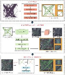
Fig. 1
Overall technical workflow"
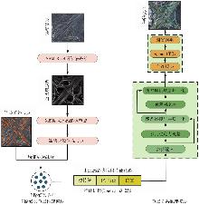
Fig. 2
Framework for candidate node construction and connectivity inference"
Fig. 3
Road node connectivity inference"
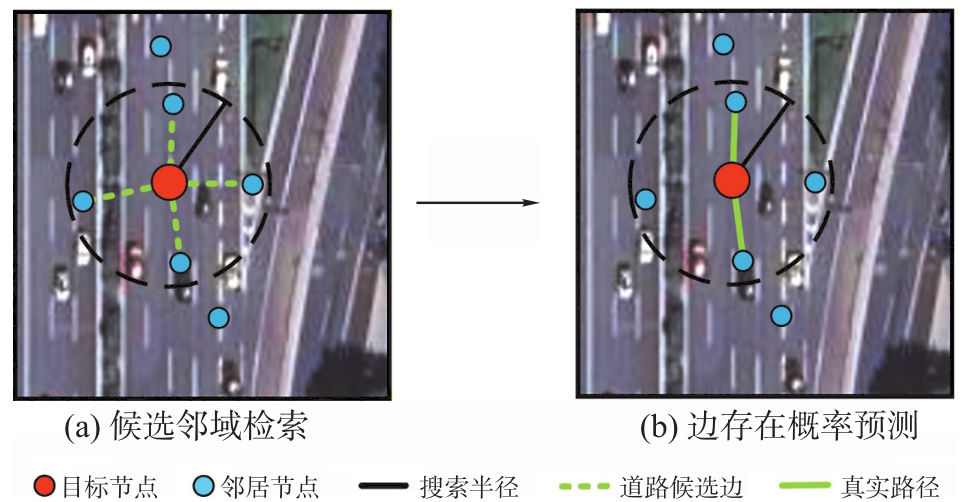
Fig. 4
Topological decoupling and path reconstruction"
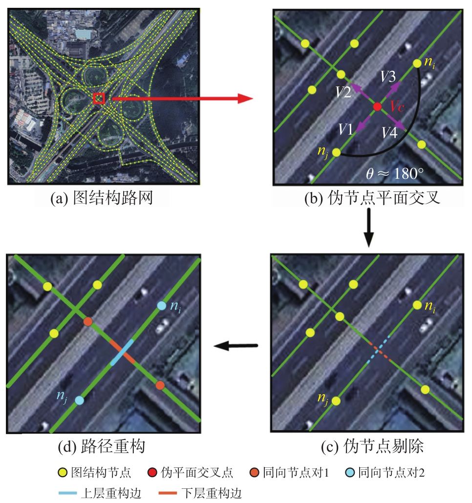
Fig. 5
Map matching and path refinement"
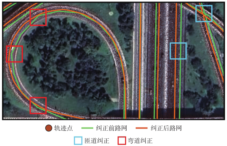
Fig. 6
Road connectivity restoration in discontinuous regions"
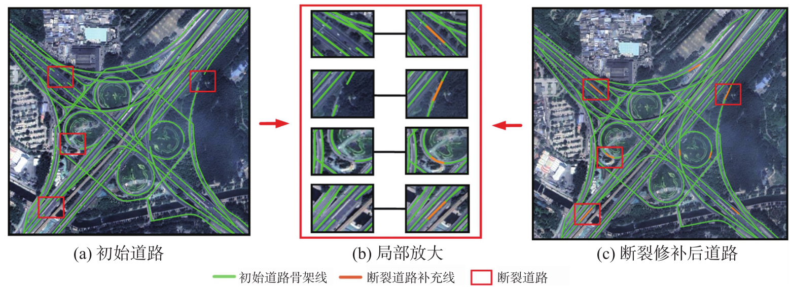
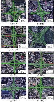
Fig. 7
Road network construction results for different interchanges"


Tab. 1
Accuracy evaluation of the results of the proposed method"
| 立交桥 | 精确率 | 召回率 | GEO-F1值 | TOPO-F1值 |
|---|---|---|---|---|
| 丽泽桥 | 0.939 8 | 0.905 1 | 0.922 1 | 0.934 7 |
| 健翔桥 | 0.971 9 | 0.922 5 | 0.946 5 | 0.952 5 |
| 建国门桥 | 0.901 3 | 0.847 5 | 0.873 6 | 0.896 6 |
| 四元桥 | 0.888 4 | 0.891 4 | 0.889 9 | 0.906 8 |
| 新兴桥 | 0.918 9 | 0.905 8 | 0.912 3 | 0.908 7 |
| 莲花桥 | 0.956 7 | 0.938 6 | 0.947 6 | 0.957 5 |
| 安慧桥 | 0.978 8 | 0.973 9 | 0.976 3 | 0.980 4 |
| 定慧桥 | 0.890 2 | 0.925 3 | 0.907 4 | 0.927 2 |
Tab. 2
Accuracy evaluation of the results of parameter sensitivity experiments"
| 判别阈值τ | 对应夹角l/(°) | GEO-F1值 | TOPO-F1值 |
|---|---|---|---|
| 0.75 | 138.6 | 0.878 5 | 0.895 6 |
| 0.85 | 148.2 | 0.889 9 | 0.906 8 |
| 0.95 | 161.8 | 0.886 7 | 0.899 4 |
Tab. 3
Accuracy evaluation of the results of ablation experiments"
| 立交桥 | 无影像候选点补充 | 无拓扑纠正 | 无地图匹配修正 | |||
|---|---|---|---|---|---|---|
| GEO-F1值 | TOPO-F1值 | GEO-F1值 | TOPO-F1值 | GEO-F1值 | TOPO-F1值 | |
| 丽泽桥 | 0.866 3 | 0.881 3 | 0.886 0 | 0.897 9 | 0.913 4 | 0.922 2 |
| 健翔桥 | 0.935 5 | 0.940 0 | 0.925 3 | 0.931 5 | 0.944 8 | 0.948 5 |
| 四元桥 | 0.825 9 | 0.858 2 | 0.859 8 | 0.890 1 | 0.864 6 | 0.891 2 |
| 新兴桥 | 0.872 9 | 0.866 8 | 0.889 5 | 0.883 4 | 0.905 1 | 0.901 6 |
| 安慧桥 | 0.894 8 | 0.909 8 | 0.967 6 | 0.978 8 | 0.966 2 | 0.974 2 |
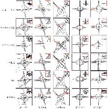
Fig. 8
Interchange road network construction results obtained by different methods"

Tab. 4
Comparison analysis of results"
| 立交桥 | 方法 | 精确率 | 召回率 | GEO-F1值 | TOPO-F1值 |
|---|---|---|---|---|---|
| 丽泽桥 | RoadRunner | 0.898 2 | 0.509 7 | 0.650 4 | 0.681 7 |
| TrackFusion | 0.977 6 | 0.878 3 | 0.925 3 | 0.925 8 | |
| Sat2Graph | 0.389 6 | 0.239 8 | 0.296 9 | 0.443 7 | |
| OSM | 0.969 1 | 0.903 4 | 0.935 1 | 0.946 7 | |
| 本文方法 | 0.939 8 | 0.905 1 | 0.922 1 | 0.934 7 | |
| 健翔桥 | RoadRunner | 0.949 7 | 0.565 4 | 0.708 8 | 0.719 6 |
| TrackFusion | 0.969 0 | 0.864 6 | 0.913 9 | 0.922 1 | |
| Sat2Graph | 0.681 2 | 0.278 2 | 0.395 1 | 0.446 2 | |
| OSM | 0.969 1 | 0.956 1 | 0.962 6 | 0.971 0 | |
| 本文方法 | 0.971 9 | 0.922 5 | 0.946 5 | 0.952 5 | |
| 四元桥 | RoadRunner | 0.787 3 | 0.600 0 | 0.681 0 | 0.719 0 |
| TrackFusion | 0.860 2 | 0.816 1 | 0.837 6 | 0.849 5 | |
| Sat2Graph | 0.358 9 | 0.311 4 | 0.333 5 | 0.458 3 | |
| OSM | 0.935 8 | 0.826 9 | 0.878 0 | 0.886 3 | |
| 本文方法 | 0.888 4 | 0.891 4 | 0.889 9 | 0.906 8 | |
| 新兴桥 | RoadRunner | 0.981 1 | 0.745 5 | 0.847 2 | 0.859 1 |
| TrackFusion | 0.971 2 | 0.742 2 | 0.841 4 | 0.853 5 | |
| Sat2Graph | 0.424 9 | 0.329 7 | 0.371 3 | 0.555 6 | |
| OSM | 0.977 7 | 0.880 8 | 0.926 7 | 0.891 2 | |
| 本文方法 | 0.918 9 | 0.905 8 | 0.912 3 | 0.908 7 | |
| 安慧桥 | RoadRunner | 0.970 1 | 0.773 1 | 0.860 4 | 0.873 5 |
| TrackFusion | 0.961 0 | 0.805 4 | 0.876 3 | 0.887 4 | |
| Sat2Graph | 0.527 7 | 0.150 4 | 0.234 1 | 0.326 3 | |
| OSM | 0.977 5 | 0.974 5 | 0.976 0 | 0.975 2 | |
| 本文方法 | 0.978 8 | 0.973 9 | 0.976 3 | 0.980 4 |
| [1] | Yang Xue, Yang Mingchun, Cao Yanjia, et al. Three-dimensional structure determination of grade-separated road intersections from crowdsourced trajectories[J]. International Journal of Applied Earth Observation and Geoinformation, 2023, 125: 103598. |
| [2] | 邓媛媛, 向隆刚, 焦凤伟. 基于正逆向追踪与融合的立交桥结构提取[J]. 地球信息科学学报, 2025, 27(10): 2373-2386. |
| Deng Yuanyuan, Xiang Longgang, Jiao Fengwei. Extraction of overpass structure based on forward and backward tracking and fusion of crowdsourced trajectory[J]. Journal of Geo-information Science, 2025, 27(10): 2373-2386. | |
| [3] |
焦凤伟, 向隆刚, 邓媛媛, 等. 轨迹局部和长序特征结合的立交桥路网构建方法[J]. 测绘学报, 2025, 54(5): 950-962. DOI: .
doi: 10.11947/j.AGCS.2025.20240130 |
|
Jiao Fengwei, Xiang Longgang, Deng Yuanyuan, et al. Constructing grade-separated junctions based on combination of local and long-term trajectory feature[J]. Acta Geodaetica et Cartographica Sinica, 2025, 54(5): 950-962. DOI: .
doi: 10.11947/j.AGCS.2025.20240130 |
|
| [4] |
张彩丽, 向隆刚, 李雅丽, 等. 基于出租车轨迹的可导航路网构建[J]. 测绘学报, 2021, 50(12): 1650-1662. DOI: .
doi: 10.11947/j.AGCS.2021.20200470 |
|
Zhang Caili, Xiang Longgang, Li Yali, et al. Construction of navigable road network based on taxi trajectory[J]. Acta Geodaetica et Cartographica Sinica, 2021, 50(12): 1650-1662. DOI: .
doi: 10.11947/j.AGCS.2021.20200470 |
|
| [5] | Deng Min, Huang Jincai, Zhang Yunfei, et al. Generating urban road intersection models from low-frequency GPS trajectory data[J]. International Journal of Geographical Information Science, 2018, 32(12): 2337-2361. |
| [6] | Stanojevic R, Abbar S, Thirumuruganathan S, et al. Robust road map inference through network alignment of trajectories[C]//Proceedings of 2018 SIAM International Conference on Data Mining. Philadelphia: Society for Industrial and Applied Mathematics, 2018. |
| [7] | Tang Jianbo, Deng Min, Huang Jincai, et al. A novel method for road intersection construction from vehicle trajectory data[J]. IEEE Access, 2019, 7: 95065-95074. |
| [8] | He Songtao, Bastani F, Abbar S, et al. RoadRunner: improving the precision of road network inference from GPS trajectories[C]//Proceedings of the 26th ACM SIGSPATIAL International Conference on Advances in Geographic Information Systems. Seattle: ACM Press, 2018: 3-12. |
| [9] | 胡瀚, 向隆刚, 王德浩. 出租车轨迹数据的道路提取[J]. 测绘通报, 2018(7): 53-57. |
| Hu Han, Xiang Longgang, Wang Dehao. Road extraction based on taxi trajectory data[J]. Bulletin of Surveying and Mapping, 2018(7): 53-57. | |
| [10] | 杨云. 改进U-Net网络的遥感影像道路提取[J]. 测绘与空间地理信息, 2025, 48(8): 110-113. |
| Yang Yun. Improved U-Net network remote sensing image road extraction[J]. Geomatics and Spatial Information Technology, 2025, 48(8): 110-113. | |
| [11] | Batra A, Singh S, Pang Guan, et al. Improved road connectivity by joint learning of orientation and segmentation[C]//Proceedings of 2019 IEEE/CVF Conference on Computer Vision and Pattern Recognition. Long Beach: IEEE, 2019. |
| [12] | Zhang Zhengxin, Liu Qingjie, Wang Yunhong. Road extraction by deep residual U-net[J]. IEEE Geoscience and Remote Sensing Letters, 2018, 15(5): 749-753. |
| [13] | 江娜, 李吉元, 杨景玉, 等. 基于拓扑增强的深度学习遥感影像道路提取方法[J]. 兰州交通大学学报, 2023, 42(2): 45-54. |
| Jiang Na, Li Jiyuan, Yang Jingyu, et al. Road extraction method of deep learning remote sensing image based on topology enhancement[J]. Journal of Lanzhou Jiaotong University, 2023, 42(2): 45-54. | |
| [14] | Mattyus G, Luo Wenjie, Urtasun R. DeepRoadMapper: extracting road topology from aerial images[C]//Proceedings of 2017 IEEE International Conference on Computer Vision. Venice. IEEE: 2017: 3458-3466. |
| [15] | He Songtao, Bastani F, Jagwani S, et al. Sat2Graph: road graph extraction through graph-tensor encoding[C]//Proceedings of 2020 European Conference on Computer Vision. Glasgow: Springer, 2020: 51-67. |
| [16] | Zhang Jinming, Hu Xiangyun, Wei Yujun, et al. Road topology extraction from satellite imagery by joint learning of nodes and their connectivity[J]. IEEE Transactions on Geoscience and Remote Sensing, 2023, 61: 5602613. |
| [17] | Bastani F, He Songtao, Abbar S, et al. RoadTracer: automatic extraction of road networks from aerial images[C]//Proceedings of 2018 IEEE/CVF Conference on Computer Vision and Pattern Recognition. Salt Lake City: IEEE, 2018: 4720-4728. |
| [18] | Xu Zhenhua, Liu Yuxuan, Gan Lu, et al. RNGDet: road network graph detection by transformer in aerial images[J]. IEEE Transactions on Geoscience and Remote Sensing, 2022, 60: 4707612. |
| [19] |
王泽矫, 向隆刚, 王猛, 等. 融合层级特征与多样化注意力的道路面与中心线协同提取网络[J]. 测绘学报, 2026, 55(3): 548-563. DOI: .
doi: 10.11947/j.AGCS.2026.20250446 |
|
Wang Zejiao, Xiang Longgang, Wang Meng, et al. Hierarchical feature and diversified attention fusion network for collaborative extraction of road surface and centerline[J]. Acta Geodaetica et Cartographica Sinica, 2026, 55(3): 548-563. DOI: .
doi: 10.11947/j.AGCS.2026.20250446 |
|
| [20] |
方志祥, 仲浩宇, 邹欣妍. 轨迹延续性与影像特征相似性结合的城市道路提取[J]. 测绘学报, 2020, 49(12): 1554-1563. DOI: .
doi: 10.11947/j.AGCS.2020.20190366 |
|
Fang Zhixiang, Zhong Haoyu, Zou Xinyan. Extracting urban road area based on combination of trajectory continuity and image feature similarity[J]. Acta Geodaetica et Cartographica Sinica, 2020, 49(12): 1554-1563. DOI: .
doi: 10.11947/j.AGCS.2020.20190366 |
|
| [21] | Yang Xue, Fan Xiang, Su Yichun, et al. TR2RM: an urban road network generation model based on multisource big data[J]. International Journal of Digital Earth, 2024, 17(1): 2344596. |
| [22] | 李雅丽. 轨迹数据与遥感影像多层次融合的城市路网结构提取[D]. 武汉: 武汉大学, 2022: 76-78. |
| Li Yali. Extraction of urban road network structure by multi-level fusion of trajectory data and remote sensing images[D]. Wuhan: Wuhan University, 2022: 76-78. | |
| [23] | Liu Lingbo, Yang Zewei, Li Guanbin, et al. Aerial images meet crowdsourced trajectories: a new approach to robust road extraction[J]. IEEE Transactions on Neural Networks and Learning Systems, 2023, 34(7): 3308-3322. |
| [24] | Zhang Chong, Zhang Huazu, Guo Xiaogang, et al. DF-BSFNet: a bilateral synergistic fusion network with novel dynamic flow convolution for robust road extraction[J]. Information Fusion, 2025, 118: 102958. |
| [25] |
邓敏, 罗斌, 唐建波, 等. 顾及轨迹密度分布异质性的道路交叉口提取方法[J]. 测绘学报, 2023, 52(6): 1000-1009. DOI: .
doi: 10.11947/j.AGCS.2023.20210173 |
|
Deng Min, Luo Bin, Tang Jianbo, et al. Extracting road intersections from vehicle trajectory data in the face of trace density disparity[J]. Acta Geodaetica et Cartographica Sinica, 2023, 52(6): 1000-1009. DOI: .
doi: 10.11947/j.AGCS.2023.20210173 |
|
| [26] | 王序哲. 局部自适应二值化方法研究[J]. 软件导刊, 2011, 10(11): 13-14. |
| Wang Xuzhe. Research on local adaptive binarization method[J]. Software Guide, 2011, 10(11): 13-14. | |
| [27] | Hetang C, Xue H, Le C, et al. Segment anything model for road network graph extraction[C]//Proceedings of 2024 IEEE/CVF Conference on Computer Vision and Pattern Recognition Workshops. Seattle: IEEE, 2024: 2556-2566. |
| [28] | Luo An, Chen Shenghua, Xu Bin. Enhanced map-matching algorithm with a hidden Markov model for mobile phone positioning[J]. ISPRS International Journal of Geo-Information, 2017, 6(11): 327. |
| [29] | Biagioni J, Eriksson J. Inferring road maps from global positioning system traces: survey and comparative evaluation[J]. Transportation Research Record: Journal of the Transportation Research Board, 2012, 2291(1): 61-71. |
| [1] | Yongqi Sun, Chenguang Dai, Zhenchao Zhang, Jinchun Qin, Yu Su. A cross-domain semantic segmentation framework fusing relative depth for high-resolution optical satellite remote sensing imagery [J]. Acta Geodaetica et Cartographica Sinica, 2026, 55(8): 1425-1438. |
| [2] | Xiangyu Zhao, Chunju Zhang, Yifan Pei, Chenxi Li, Jun Zhang, Wei Xu, Chun Lan, Linfeng Lü, Hongbo Liang. SCA-SAM: semantic segmentation for remote sensing images based on scale context attention and efficient SAM transfer [J]. Acta Geodaetica et Cartographica Sinica, 2026, 55(8): 1452-1464. |
| [3] | Tiandong SHI, Ling ZHAO, Wenhao ZHAO, Ji QI, Hao CUI, Chengli PENG, Xinchang ZHANG. Controllable generation of high-resolution optical remote sensing image explicitly guided by spatio-temporal information [J]. Acta Geodaetica et Cartographica Sinica, 2026, 55(5): 894-908. |
| [4] | Rui YU, Jie LI, Huihui LIU, Meiru WU, Liupeng LIN, Qiangqiang YUAN, Li ZHENG. Heterogeneous remote sensing change detection based on vision-language collaborative representation for flood disasters [J]. Acta Geodaetica et Cartographica Sinica, 2026, 55(5): 927-940. |
| [5] | Shunping JI, Jin LIU, Jian GAO, Jianya GONG. An intelligent 3D reconstruction framework via deep learning based multi-view image matching [J]. Acta Geodaetica et Cartographica Sinica, 2025, 54(9): 1633-1646. |
| [6] | Yakun XIE, Yaoji ZHAO, Jiaxing TU, Ruifeng XIA, Dejun FENG, Suning LIU, Hongyu CHEN, Jun ZHU. Edge and global features integrated network for salient object detection in optical remote sensing images [J]. Acta Geodaetica et Cartographica Sinica, 2025, 54(7): 1265-1279. |
| [7] | Zibo DONG, Jingxue WANG, Lijing BU, Lin FANG, Zhenghui XU. MAFNet: building extraction method from remote sensing images based on multi-scale atrous fusion network [J]. Acta Geodaetica et Cartographica Sinica, 2025, 54(6): 1094-1106. |
| [8] | Haifeng LI, Wang GUO, Mengwei WU, Chengli PENG, Qing ZHU, Yu LIU, Chao TAO. Visual-language joint representation and intelligent interpretation of remote sensing geo-objects: principles, challenges and opportunities [J]. Acta Geodaetica et Cartographica Sinica, 2025, 54(5): 853-872. |
| [9] | Chao WANG, Tianyu CHEN, Tong ZHANG, Tanvir AHMED, Liqiang JI, Tao XIE, Jiajun YANG, Shuai WANG. Multi-sensor optical remote sensing images change detection based on global differential enhancement module and balance penalty loss [J]. Acta Geodaetica et Cartographica Sinica, 2025, 54(5): 873-887. |
| [10] | Yiming ZHAO, Kelin HU, Kelong TU, Yaxian QING, Chao YANG, Kunlun QI, Huayi WU. Multi-label scene classification method based on fusion of SAR and optical remote sensing images [J]. Acta Geodaetica et Cartographica Sinica, 2025, 54(5): 911-923. |
| [11] | Fengwei JIAO, Longgang XIANG, Yuanyuan DENG, Xin CHEN, Huayi WU. Constructing grade-separated junctions based on combination of local and long-term trajectory feature [J]. Acta Geodaetica et Cartographica Sinica, 2025, 54(5): 950-962. |
| [12] | Xinchang ZHANG, Ji QI, Chao TAO, Siyang FU, Mingning GUO, Yongjian RUAN. A survey on cloud removal in optical remote sensing images: progress, challenges, and future works [J]. Acta Geodaetica et Cartographica Sinica, 2025, 54(4): 603-620. |
| [13] | Zhaoyang HOU, Haowen YAN, Liming ZHANG, Rongjuan MA, Ruitao QU. Zero-watermark copyright protection method for remote sensing images based on coupled neural P system and blockchain [J]. Acta Geodaetica et Cartographica Sinica, 2025, 54(12): 2247-2261. |
| [14] | Xi GONG, Zhanlong CHEN, Hengqiang ZHENG, Sheng HU, Hongyan ZHANG. Remote sensing image scene classification method integrating spatial and semantic information of transferred features [J]. Acta Geodaetica et Cartographica Sinica, 2025, 54(11): 2009-2025. |
| [15] | Zhili ZHANG, Huiwei JIANG, Xiangyun HU. A minimal-interaction framework for accurate and batch extraction of geospatial objects from remote sensing imagery [J]. Acta Geodaetica et Cartographica Sinica, 2025, 54(10): 1863-1876. |
| Viewed | ||||||
|
Full text |
|
|||||
|
Abstract |
|
|||||
