

Acta Geodaetica et Cartographica Sinica ›› 2024, Vol. 53 ›› Issue (11): 2125-2137.doi: 10.11947/j.AGCS.2024.20230473
• Geodesy and Navigation • Previous Articles Next Articles
Qimin HE1,2,3( ), Kefei ZHANG4(), Li LI1, Dajun LIAN1, Wei ZHAO1, Guodong CHEN1, Erjiang FU5, Rui WANG6
Received:2023-10-25
Online:2024-12-13
Published:2024-12-13
Contact:
Kefei ZHANG
E-mail:heqimin@usts.edu.cn;profkzhang@cumt.edu.cn
About author:HE Qimin (1994—), male, PhD, lecturer, majors in GNSS meteorology. E-mail: heqimin@usts.edu.cn
Supported by:CLC Number:
Qimin HE, Kefei ZHANG, Li LI, Dajun LIAN, Wei ZHAO, Guodong CHEN, Erjiang FU, Rui WANG. A four-parameter model for estimating typhoon motion states based on time difference of PWV arrival[J]. Acta Geodaetica et Cartographica Sinica, 2024, 53(11): 2125-2137.
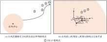
Fig.1
Relation between the typhoon's movement path and the positions of ERA5 grids"
Tab.1
Geodetic coordinates and elevations of GNSS stations"
| 站点 | 经度 | 纬度 | 高程/m |
|---|---|---|---|
| BJFS | 115.89°E | 39.61°N | 87.5 |
| CHAN | 125.44°E | 43.79°N | 273.2 |
| CKSV | 120.22°E | 23.00°N | 59.7 |
| HKSL | 113.93°E | 22.37°N | 95.3 |
| HKWS | 114.34°E | 22.43°N | 63.8 |
| JFNG | 114.49°E | 30.52°N | 71.3 |
| KMNM | 118.39°E | 24.46°N | 49.1 |
| LHAZ | 91.10°E | 29.66°N | 3 624.6 |
| NCKU | 120.22°E | 23.00°N | 98.3 |
| SHAO | 121.20°E | 31.10°N | 22.0 |
| TWTF | 121.16°E | 24.95°N | 201.5 |
| URUM | 87.60°E | 43.81°N | 858.9 |
| WUH2 | 114.36°E | 30.53°N | 28.2 |
| TCMS | 120.99°E | 24.80°N | 77.2 |
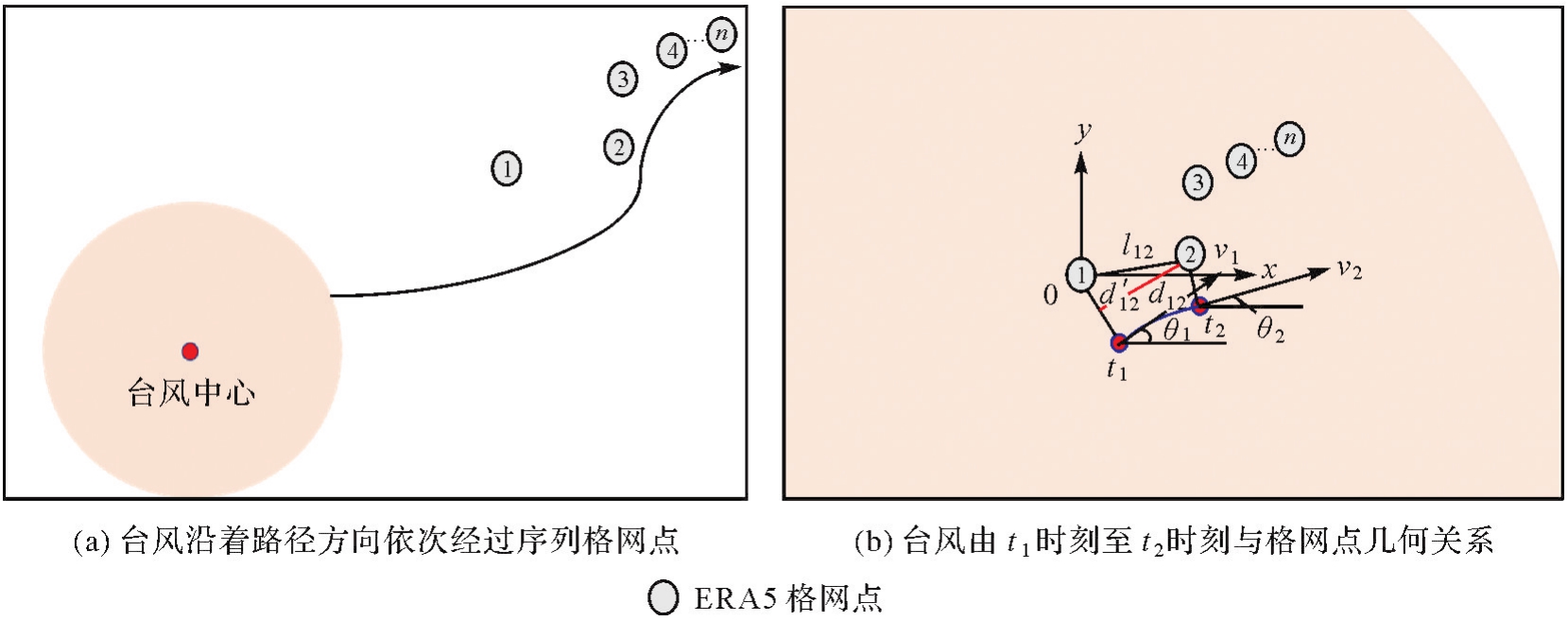
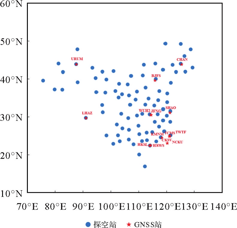
Fig.2
Geographical distribution of the GNSS stations and RS stations"
Tab.2
Comparison results of the GNSS-PWV time series and ERA5-PWV time series"
| 站点 | Bias/mm | RMSE/mm | STD/mm | 皮尔逊相关系数 |
|---|---|---|---|---|
| BJFS | 0.42 | 2.71 | 2.68 | 0.98 |
| CHAN | -0.60 | 2.50 | 2.42 | 0.98 |
| CKSV | 0.09 | 2.92 | 2.92 | 0.97 |
| HKSL | 0.97 | 2.53 | 2.34 | 0.98 |
| HKWS | 0.86 | 2.45 | 2.29 | 0.98 |
| JFNG | 1.08 | 2.96 | 2.76 | 0.98 |
| KMNM | 0.53 | 2.77 | 2.72 | 0.98 |
| LHAZ | 2.24 | 3.11 | 2.15 | 0.96 |
| NCKU | -0.29 | 2.84 | 2.83 | 0.98 |
| SHAO | -0.66 | 2.44 | 2.35 | 0.94 |
| TWTF | 1.36 | 3.07 | 2.75 | 0.98 |
| URUM | 1.17 | 2.51 | 2.23 | 0.95 |
| WUH2 | 0.68 | 3.01 | 2.93 | 0.98 |
| TCMS | 0.93 | 3.20 | 3.06 | 0.97 |
| 平均 | 0.63 | 2.79 | 2.60 | 0.97 |
Fig.3
Comparison results of the RS-PWV and ERA5-PWV"
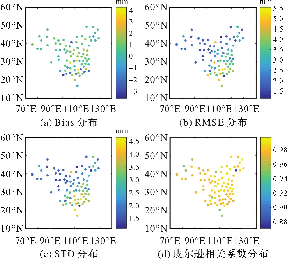
Fig.4
Spatial distributions of PWV every 6 h during typhoons' periods"
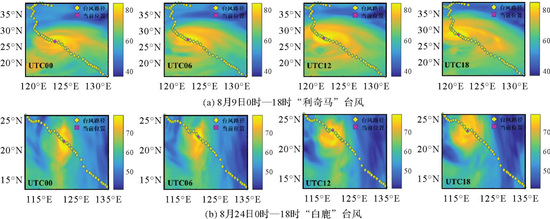
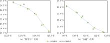
Fig.5
The paths of typhoons and the ERA5 grids around the paths"
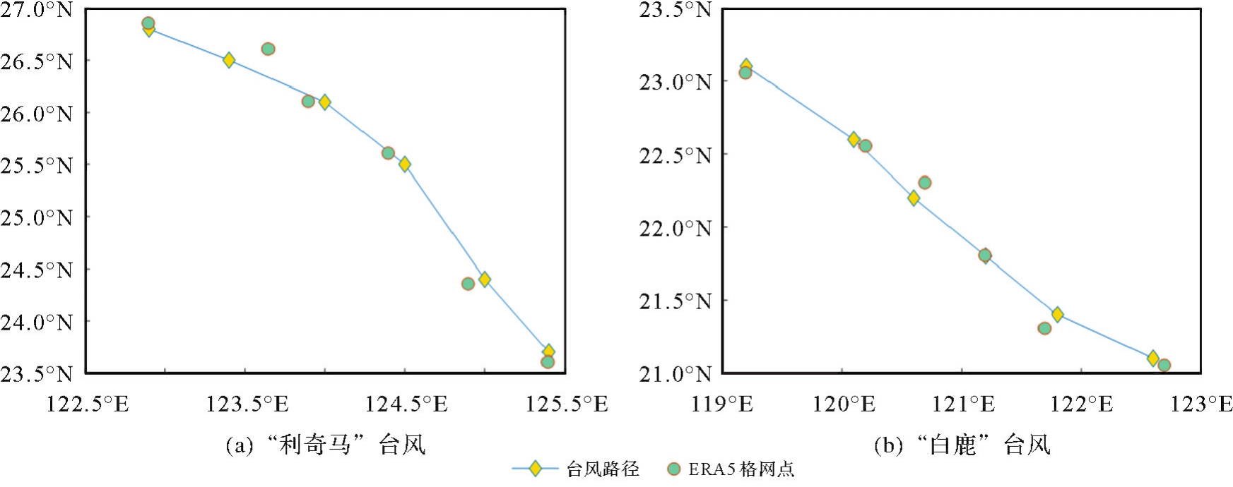
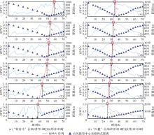
Fig.6
PWV time series and distance from typhoon track center during typhoons' periods"
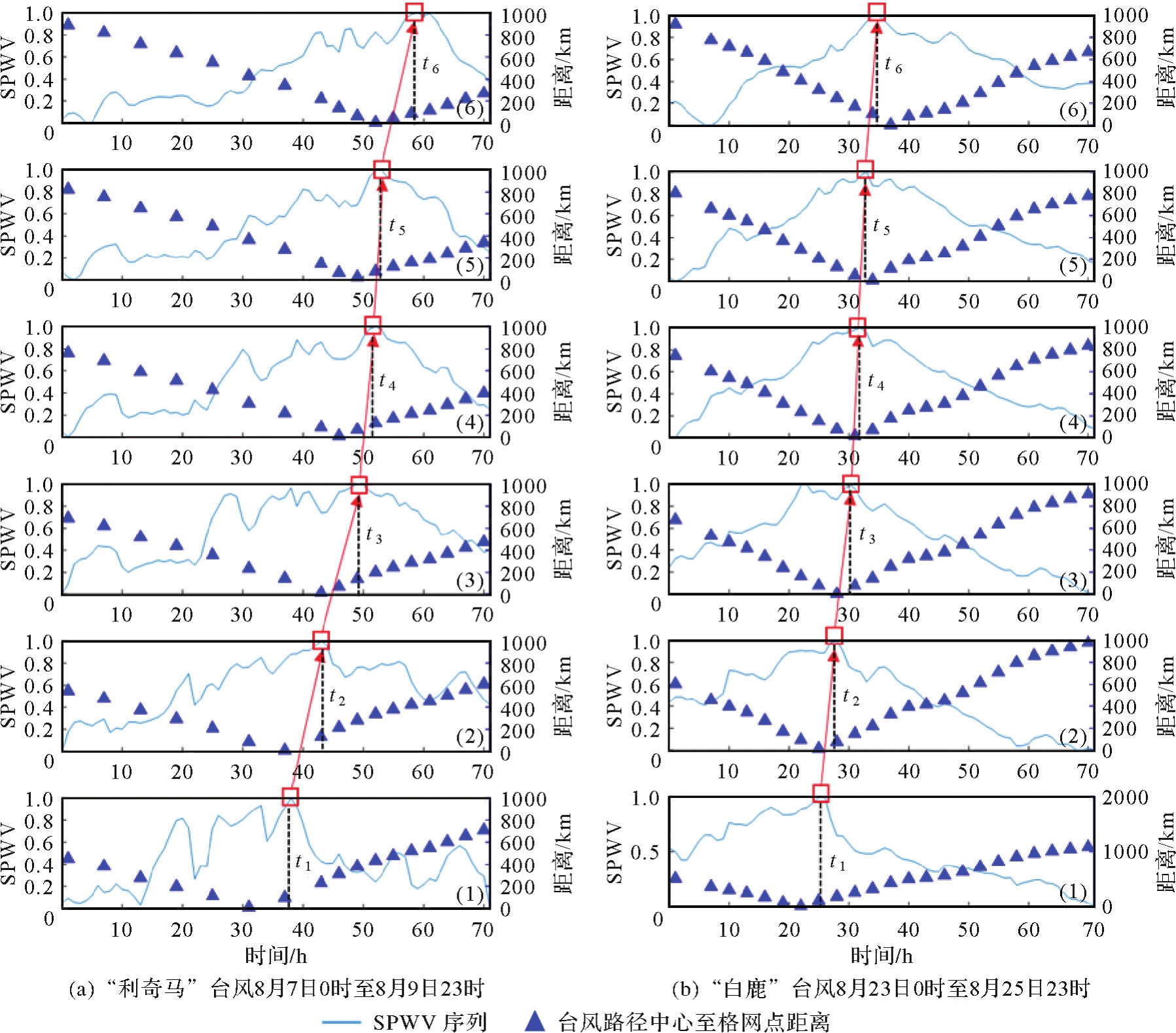
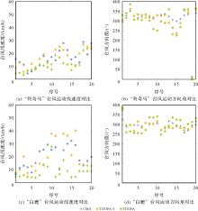
Fig.7
Comparison results of the TDOPA-4, TDOPA and CMA derived velocity and direction angle of typhoons"
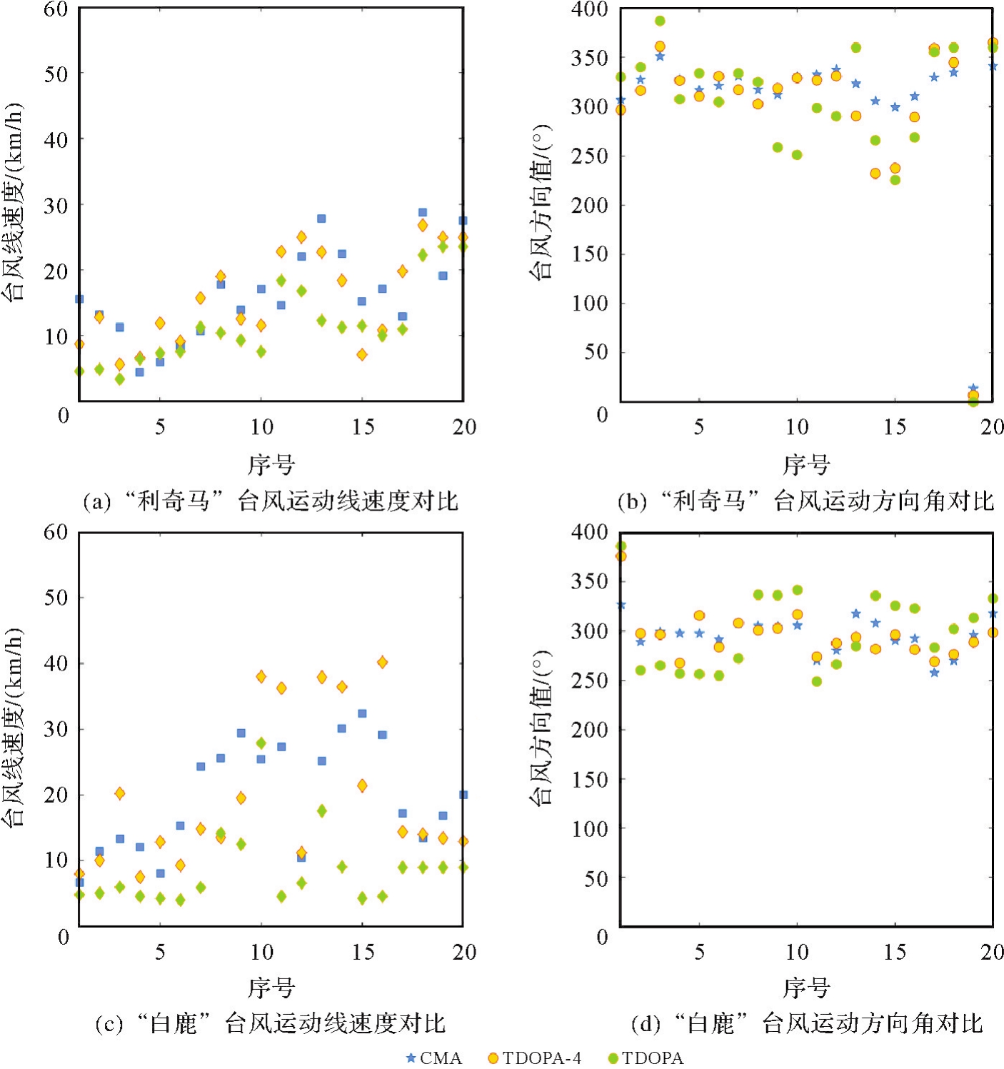
Fig.8
Comparison results of TDOPA-4, TDOPA and PGZP derived velocity of typhoons"

Tab.3
Comparison results of velocity and direction angle"
| 台风 | 模型 | CMA线速度/(km/h) | CMA方向角/(°) | PGZP线速度/(km/h) | ||||||
|---|---|---|---|---|---|---|---|---|---|---|
| Bias | RMSE | STD | Bias | RMSE | STD | Bias | RMSE | STD | ||
| 利奇马 | TDOPA-4 | 0.43 | 4.97 | 4.95 | 8.78 | 25.82 | 24.28 | -0.60 | 3.99 | 3.95 |
| TDOPA | 4.62 | 6.99 | 5.25 | 10.68 | 37.17 | 35.60 | 3.63 | 5.68 | 4.37 | |
| 白鹿 | TDOPA-4 | 0.08 | 7.81 | 7.81 | 0.58 | 17.37 | 17.38 | 5.06 | 6.84 | 4.60 |
| TDOPA | 11.09 | 13.70 | 8.04 | -2.88 | 32.84 | 32.97 | 14.37 | 15.09 | 4.62 | |
| [1] |
黄良珂, 莫智翔, 刘立龙, 等. 顾及时变递减因子的中国大陆地区大气可降水量垂直改正模型[J]. 测绘学报, 2021, 50(10): 1320-1330. DOI:.
doi: 10.11947/j.AGCS.2021.20200530 |
|
HUANG Liangke, MO Zhixiang, LIU Lilong, et al. An empirical model for the vertical correction of precipitable water vapor considering the time-varying lapse rate for mainland China[J]. Acta Geodaetica et Cartographica Sinica, 2021, 50(10): 1320-1330. DOI:.
doi: 10.11947/j.AGCS.2021.20200530 |
|
| [2] |
姚宜斌, 赵庆志. GNSS对流层水汽监测研究进展与展望[J]. 测绘学报, 2022, 51(6): 935-952. DOI:.
doi: 10.11947/j.AGCS.2022.20220039 |
|
YAO Yibin, ZHAO Qingzhi. Research progress and prospect of monitoring tropospheric water vapor by GNSS technique[J]. Acta Geodaetica et Cartographica Sinica, 2022, 51(6): 935-952. DOI:.
doi: 10.11947/j.AGCS.2022.20220039 |
|
| [3] | 饶晨泓, 毕鑫鑫, 陈光华, 等. 近海台风对“21·7”河南极端暴雨过程水汽通量和动、热力条件影响的模拟[J]. 大气科学, 2022, 46(6): 1577-1594. |
| RAO Chenhong, BI Xinxin, CHEN Guanghua, et al. A numerical simulation on the impacts of the offshore typhoons on water vapor flux, dynamic and thermal conditions of the extreme rainstorm event in Henan province in July 2021[J]. Chinese Journal of Atmospheric Sciences(in Chinese), 46(6): 1577-1594. | |
| [4] | BONAFONI S, BIONDI R, BRENOT H, et al. Radio occultation and ground-based GNSS products for observing, understanding and predicting extreme events: a review[J]. Atmospheric Research, 2019, 230: 104624. |
| [5] | HE Q, ZHANG K, WU S, et al. An investigation of atmospheric temperature and pressure using an improved spatio-temporal Kriging model for sensing GNSS-derived precipitable water vapor[J]. Spatial Statistics, 2022, 51: 100664. |
| [6] | YU S, LIU Z. Temporal and spatial impact of precipitable water vapor on GPS relative positioning during the tropical cyclone Hato (2017) in Hong Kong and Taiwan[J]. Earth and Space Science, 2021, 8(4): e2020EA001371. |
| [7] | 朱明晨. GNSS水汽反演技术精化及台风水汽动态监测[D]. 南京: 东南大学, 2022. |
| ZHU Mingchen. GNSS water vapor inversion technology improvement and dynamic monitoring during typhoon events[D]. Nanjing: Southeast University, 2022. | |
| [8] | WON J, KIM D. Analysis of temporal and spatial variation of precipitable water vapor according to path of typhoon EWINIAR using GPS permanent stations[J]. Journal of Positioning, Navigation, and Timing, 2015, 4(2): 87-95. |
| [9] | ZHAO Q, MA X, YAO W, et al. A new typhoon-monitoring method using precipitation water vapor[J]. Remote Sensing, 2019, 11(23): 2845. |
| [10] | HE Q, ZHANG K, WU S, et al. Real-time GNSS-derived PWV for typhoon characterizations: a case study for super typhoon Mangkhut in Hong Kong[J]. Remote Sensing, 2019, 12(1): 104. |
| [11] | KANG I, PARK J. Use of GNSS-derived PWV for predicting the path of typhoon: case studies of Soulik and Kongrey in 2018[J]. Journal of Surveying Engineering, 2021, 147(4): 04021018. |
| [12] | NYKIEL G, FIGURSKI M, BALDYSZ Z. Analysis of GNSS sensed precipitable water vapour and tropospheric gradients during the derecho event in Poland of 11th August 2017[J]. Journal of Atmospheric and Solar-Terrestrial Physics, 2019, 193: 105082. |
| [13] | 赵庆志. 地基GNSS水汽反演关键技术研究及其应用[D]. 武汉: 武汉大学, 2017. |
| ZHAO Qingzhi. Studies on the key technologies in water vapor inversion using ground-based GNSS and its applications[D]. Wuhan: Wuhan University, 2017. | |
| [14] | SHOJI Y, KUNII M, SAITO K. Mesoscale data assimilation of Myanmar cyclone Nargis part II: assimilation of GPS-derived precipitable water vapor[J]. Journal of the Meteorological Society of Japan, 2011, 89(1): 67-88. |
| [15] | TU M, ZHANG W, BAI J, et al. Spatio-temporal variations of precipitable water vapor and horizontal tropospheric gradients from GPS during Typhoon Lekima[J]. Remote Sensing, 2021, 13(20): 4082. |
| [16] | LI Z, WANG J, WEI C, et al. Analysis of the temporal and spatial characteristics of PWV and rainfall with the typhoon movement: a case study of ‘Meihua’ in 2022[J]. Atmosphere, 2023, 14(8): 1313. |
| [17] | WANG S, QIAO X. A local data assimilation method (local DA v1.0) and its application in a simulated typhoon case[J]. Geoscientific Model Development, 2022, 15(23): 8869-8897. |
| [18] | 何琦敏. 地基GNSS水汽反演及其在极端天气中的应用研究[D]. 徐州: 中国矿业大学, 2021. |
| HE Qimin. Water vapor retrieved from ground-based GNSS and its applications in extreme weather studies[D]. Xuzhou: China University of Mining and Technology, 2021. | |
| [19] |
张克非, 李浩博, 王晓明, 等. 地基GNSS大气水汽探测遥感研究进展和展望[J]. 测绘学报, 2022, 51(7): 1172-1191. DOI:.
doi: 10.11947/j.AGCS.2022.20220149 |
|
ZHANG Kefei, LI Haobo, WANG Xiaoming, et al. Recent progresses and future prospectives of ground-based GNSS water vapor sounding[J]. Acta Geodaetica et Cartographica Sinica, 2022, 51(7): 1172-1191. DOI:.
doi: 10.11947/j.AGCS.2022.20220149 |
|
| [20] | 张雅杰. T市S局测绘类国家秘密信息保护机制研究[D]. 天津: 天津大学, 2019. |
| ZHANG Yajie. Study on the protection mechanism of surveying and mapping state secret information in S Bureau of T city[D]. Tianjin: Tianjin University, 2019. | |
| [21] |
黎峻宇, 姚宜斌, 刘立龙, 等. 基于多源数据和广义回归神经网络的ZWD预报模型[J]. 测绘学报, 2023, 52(9): 1492-1503. DOI:.
doi: 10.11947/j.AGCS.2023.20220084 |
|
LI Junyu, YAO Yibin, LIU Lilong, et al. A predicting ZWD model based on multi-source data and generalized regression neural network[J]. Acta Geodaetica et Cartographica Sinica, 2023, 52(9): 1492-1503. DOI:.
doi: 10.11947/j.AGCS.2023.20220084 |
|
| [22] | LI J, ZHANG Q, LIU L, et al. A refined zenith tropospheric delay model for mainland China based on the global pressure and temperature 3 (GPT3) model and random forest[J]. GPS Solutions, 2023, 27(4): 172. |
| [23] | HUANG L, ZHU G, PENG H, et al. An improved global grid model for calibrating zenith tropospheric delay for GNSS applications[J]. GPS Solutions, 2023, 27(1): 17. |
| [24] | THAYER G D. An improved equation for the radio refractive index of air[J]. Radio Science, 1974, 9(10): 803-807. |
| [25] | LIAN D, HE Q, LI L, et al. A novel method for monitoring tropical cyclones' movement using GNSS zenith tropospheric delay[J]. Remote Sensing, 2023, 15(13): 3247. |
| [26] | BEVIS M, BUSINGER S, HERRING T A, et al. GPS meteorology: remote sensing of atmospheric water vapor using the global positioning system[J]. Journal of Geophysical Research: Atmospheres, 1992, 97(D14): 15787-15801. |
| [27] | YAO Yibin, SUN Zhangyu, XU Chaoqian. Applicability of Bevis formula at different height levels and global weighted mean temperature model based on near-earth atmospheric temperature[J]. Journal of Geodesy and Geoinformation Science, 2020, 3(1): 1-11. |
| [28] | PAVLIS N K, HOLMES S A, KENYON S C, et al. The development and evaluation of the Earth Gravitational Model 2008 (EGM2008)[J]. Journal of Geophysical Research (Solid Earth), 2012, 117: B04406. |
| [29] | VEDEL H. Conversion of WGS84 geometric heights to NWP model HIRLAM geopotential heights, Danish Meteorological Institute[J/OL]. [2023-04-05]. https://www.dmi.dk/fileadmin/Rapporter/SR/sr00-04.pdf. |
| [30] | YING M, ZHANG W, YU H, et al. An overview of the China meteorological administration tropical cyclone database[J]. Journal of Atmospheric and Oceanic Technology, 2014, 31(2): 287-301. |
| [31] | LU Xiaoqin, YU Hui, YING Ying, et al. Western North Pacific tropical cyclone database created by the China Meteorological Administration[J]. Advances in Atmospheric Sciences, 2021, 38(4): 690-699. |
| [32] | TAN J, CHEN B, WANG W, et al. Evaluating precipitable water vapor products from Fengyun-4A meteorological satellite using radiosonde, GNSS, and ERA5 Data[J]. IEEE Transactions on Geoscience and Remote Sensing, 2022, 60: 1-12. |
| [33] | OFFILER D, JONES J, BENNIT G, et al. EIG EUMETNET GNSS water vapour programme (E-GVAP-II)[J/OL]. [2023-05-15]. https://egvap.dmi.dk. |
| [1] | Jinwei BU, Shuhui LIU, Shunshuang XU, Tongsu XIANG, Qiulan WANG, Chaoying JI, Xiaoqing ZUO. Construction of an empirical model for estimating the global wave period of spaceborne GNSS-R [J]. Acta Geodaetica et Cartographica Sinica, 2026, 55(4): 684-697. |
| [2] | Tangting WU, Xinyu LUO, Liguo LU, Zhanke LIU, Nengfang CHAO. Assessment of water resource changes and drought characteristics in the Shaanxi, Gansu and Ningxia region based on GNSS and GRACE/GRACE-FO [J]. Acta Geodaetica et Cartographica Sinica, 2026, 55(3): 439-450. |
| [3] | Zhongmin MA, Shuangcheng ZHANG, Xin ZHOU, Qi LIU, Ning LIU, Hengli WANG. A flood monitoring method using FY-3 GNSS-R accounting for surface reflectivity uncertainty: a case study of the August 2 Guangdong rainstorm disaster [J]. Acta Geodaetica et Cartographica Sinica, 2026, 55(3): 451-464. |
| [4] | Qingyun YAN, Zixuan GUO, Yuanjin PAN, Yan JIA, Shuanggen JIN. Quantitative driving factors and zoning patterns of GNSS-R land surface reflectivity spatial heterogeneity [J]. Acta Geodaetica et Cartographica Sinica, 2026, 55(2): 315-327. |
| [5] | Qingzhi ZHAO, Duoduo JIANG, Yibin YAO, Zhi MA, Yongjie MA, Haojie LI, Ruirui XUE. An adaptive method for selecting the optimal GNSS satellite signal for water vapor tomography [J]. Acta Geodaetica et Cartographica Sinica, 2026, 55(1): 25-35. |
| [6] | Deying YU, Houpu LI, Yi LIU, Shuguang WU, Deyan LI, Mingchao LI, Wenkui LI, Shaofeng BIAN. A DBSCAN-based RAIM algorithm for multiple gross error identification [J]. Acta Geodaetica et Cartographica Sinica, 2026, 55(1): 59-72. |
| [7] | Dongliang CHENG, Lingqiu CHEN, Zhiyong HUANG, Shubo QIAO, Dandan WANG, Yaming YAN. Performance evaluation of COATS-based multi-mode and multi-frequency iGNSS-R altimetry [J]. Acta Geodaetica et Cartographica Sinica, 2026, 55(1): 73-89. |
| [8] | Yarong LUO, Wentao LU, Chi GUO, Jingnan LIU. Left-handed symmetry equivariant filtering model and algorithm for GNSS/INS integrated navigation [J]. Acta Geodaetica et Cartographica Sinica, 2025, 54(8): 1389-1403. |
| [9] | Yangyi CHEN, Kai ZHENG, Xiaohong ZHANG, Mingkui WU, Pengxu WANG, Wenju FU, Kezhong LIU. GPS/Galileo/BDS overlapping frequencies multipath error analysis and modeling [J]. Acta Geodaetica et Cartographica Sinica, 2025, 54(8): 1427-1438. |
| [10] | Jianzhang LI, Haowen YAN, Weifang YANG, Xiaoning SU. GNSS pseudo trigonometric leveling method [J]. Acta Geodaetica et Cartographica Sinica, 2025, 54(7): 1170-1177. |
| [11] | Qingzhi ZHAO, Lulu CHANG, Yibin YAO, Haojie LI. A method for constructing a hydrological drought index integrated with GNSS and meteorological data [J]. Acta Geodaetica et Cartographica Sinica, 2025, 54(7): 1192-1205. |
| [12] | Qianxin WANG, Chao HU, Tong CHENG. A method for satellite ultra-rapid orbit and clock offset estimation based on the prior information of the GNSS clock parameters [J]. Acta Geodaetica et Cartographica Sinica, 2025, 54(6): 982-994. |
| [13] | Yang SHEN, Guangyun LI, Mingjian CHEN, Linyang LI, Xingyu SHI, Wei CAI, Weifeng HAO. Assessment of GNSS ionosphere models based on FY-3 TEC in polar regions [J]. Acta Geodaetica et Cartographica Sinica, 2025, 54(6): 995-1008. |
| [14] | Shunqiang HU, Kejie CHEN, Xiaoxing HE, Hai ZHU, Tan WANG. The impact of environmental loading on nonlinear variations of 3D coordinate time series of GNSS stations in Sichuan and Yunnan region [J]. Acta Geodaetica et Cartographica Sinica, 2025, 54(5): 805-818. |
| [15] | Wentao YANG, Fei GUO, Xiaohong ZHANG, Zhiyu ZHANG, Yifan ZHU, Zheng LI, Ziheng WU. Soil moisture and freeze-thaw map using GNSS reflectometer and SMAP radiometer for Qinghai-Xizang Plateau [J]. Acta Geodaetica et Cartographica Sinica, 2025, 54(4): 725-735. |
| Viewed | ||||||
|
Full text |
|
|||||
|
Abstract |
|
|||||