

Acta Geodaetica et Cartographica Sinica ›› 2026, Vol. 55 ›› Issue (7): 1240-1253.doi: 10.11947/j.AGCS.2026.20250484
• Geodesy and Navigation • Previous Articles
Hao Lu1( ), Wei Feng1(), Xiaobing Wang2, Wei Chen3, Min Zhong1
Received:2025-11-19
Revised:2026-07-07
Published:2026-08-18
Contact:
Wei Feng
E-mail:luhao23@mail2.sysu.edu.cn;fengwei@mail.sysu.edu.cn
About author:Lu Hao (2000—), male, master, majors in hydrogeodesy. E-mail: luhao23@mail2.sysu.edu.cn
Supported by:CLC Number:
Hao Lu, Wei Feng, Xiaobing Wang, Wei Chen, Min Zhong. Assessing the capability and accuracy of SWOT satellite river observations in China[J]. Acta Geodaetica et Cartographica Sinica, 2026, 55(7): 1240-1253.
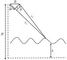
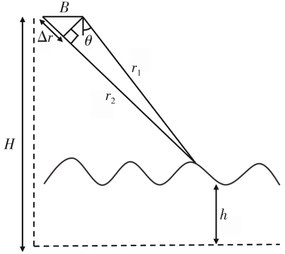
Fig. 1
SWOT measurement principle"

Tab. 1
Errors budget for SWOT inland water altimetry"
| 误差来源 | 高程误差/cm |
|---|---|
| 电离层信号 | 0.8 |
| 干对流层信号 | 0.7 |
| 湿对流层信号 | 4.0 |
| 径向轨道误差 | 1.6 |
| KaRIn随机+系统误差 | 8.9 |
| 运动误差 | 0.8 |
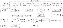
Fig. 2
Flowchart of the research methodology"
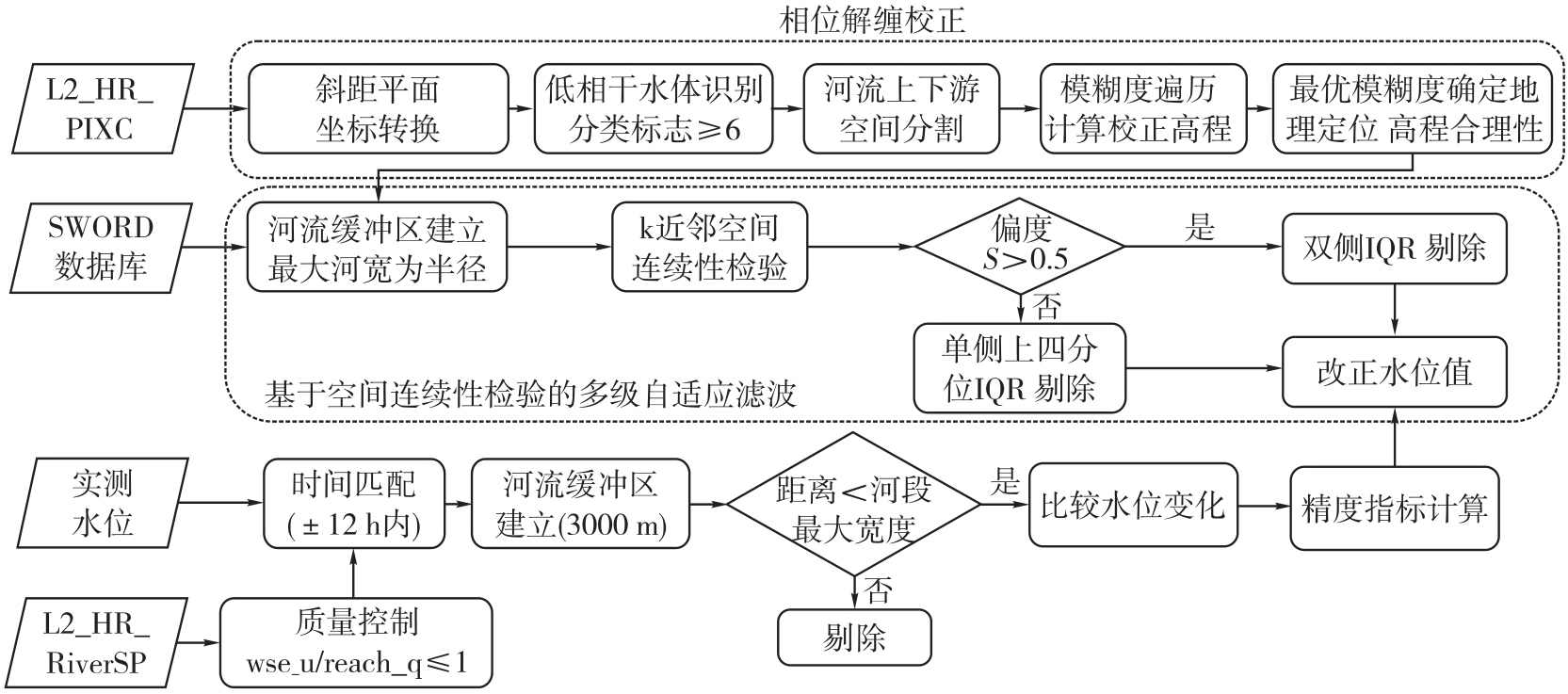
Fig. 3
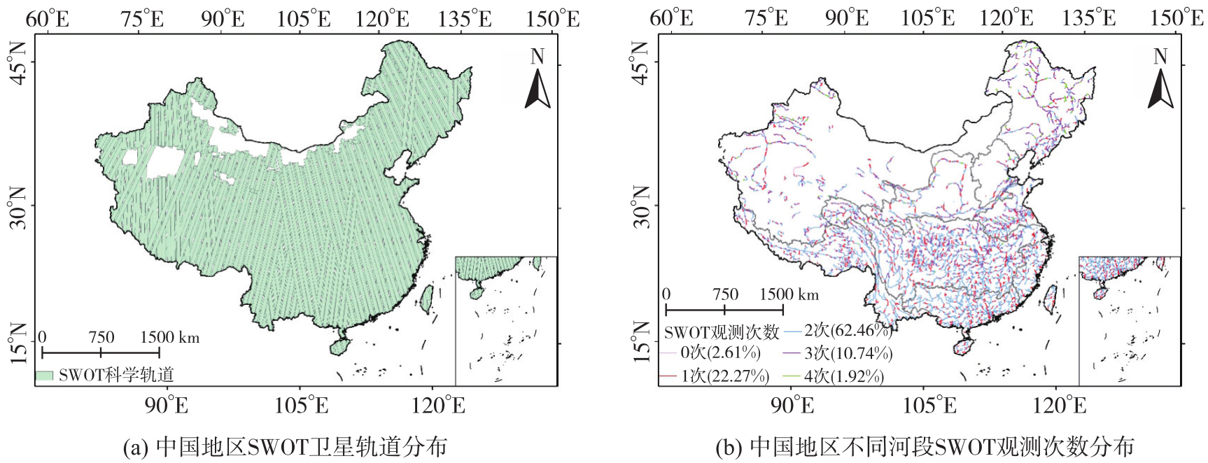
Spatial distribution of SWOT satellite orbits and observation counts across different river reaches in China"
Tab. 2
SWOT river observation capabilities across different basins"
| 流域 | 河段数 | 单个周期观测次数占比 | 河宽<50 m占比次 | ||||
|---|---|---|---|---|---|---|---|
| 0次 | 1次 | 2次 | 3次 | 4次 | |||
| 长江流域 | 9737 | 2.63 | 22.73 | 66.53 | 7.89 | 0.23 | 18.61 |
| 珠江流域 | 3960 | 3.13 | 25.91 | 70.96 | 0 | 0 | 24.19 |
| 松辽流域 | 2518 | 2.46 | 15.85 | 40.63 | 30.10 | 10.96 | 23.11 |
| 西南诸河 | 2046 | 1.76 | 21.26 | 68.04 | 8.75 | 0.20 | 25.56 |
| 内陆河 | 1881 | 4.73 | 19.88 | 48.33 | 23.23 | 3.83 | 25.78 |
| 东南诸河 | 1530 | 1.18 | 23.14 | 72.88 | 2.81 | 0 | 16.27 |
| 淮河流域 | 1502 | 1.6 | 20.84 | 62.85 | 13.12 | 1.60 | 11.72 |
| 黄河流域 | 1489 | 1.68 | 25.12 | 57.56 | 13.57 | 2.08 | 16.59 |
| 海河流域 | 460 | 3.26 | 22.83 | 43.91 | 23.26 | 6.74 | 27.83 |
Fig. 4
Spatial distribution of successfully matched stations"
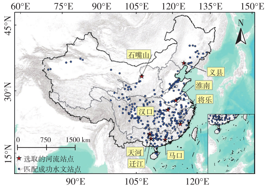
Fig. 5
SWOT orbit distribution of river stations"
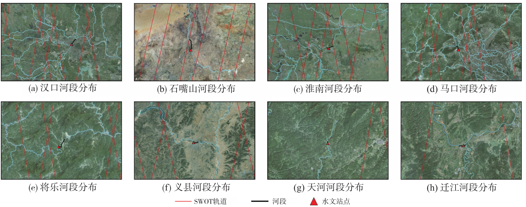
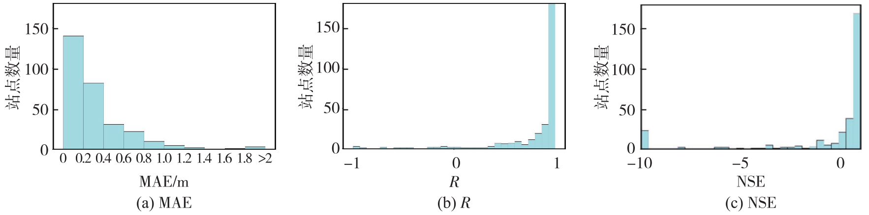
Fig. 6
Water level change comparison between SWOT and in-situ measurements in China"
Tab. 3
SWOT water level accuracy metrics for different river basins in China"
| 流域 | 水位变化的平均MAE/m | MAE标准差/m | 最大MAE/m | 最小MAE/m | 站点数量 |
|---|---|---|---|---|---|
| 东南诸河 | 0.43 | 0.30 | 1.13 | 0.07 | 20 |
| 内陆河 | 0.46 | 0.40 | 1.32 | 0.07 | 8 |
| 松辽流域 | 0.20 | 0.14 | 0.50 | 0.05 | 17 |
| 海河流域 | 0.21 | 0.12 | 0.34 | 0.10 | 3 |
| 淮河流域 | 0.14 | 0.15 | 0.71 | 0.02 | 25 |
| 珠江流域 | 0.42 | 0.64 | 4.54 | 0.02 | 58 |
| 长江流域 | 0.41 | 0.52 | 3.05 | 0.02 | 129 |
| 黄河流域 | 0.29 | 0.27 | 1.02 | 0.04 | 41 |
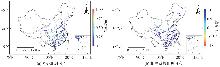
Fig. 7
Spatial distribution of SWOT observational performance metrics in different regions"
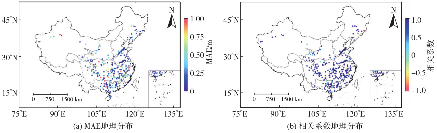
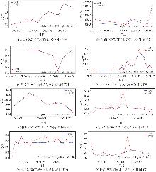
Fig. 8
Comparison of SWOT and in-situ water level time series for different rivers"

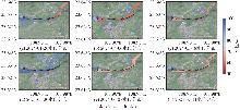
Fig. 9
Spatial distribution of water surface elevation based on SWOT pixel cloud data (Qianjiang station)"
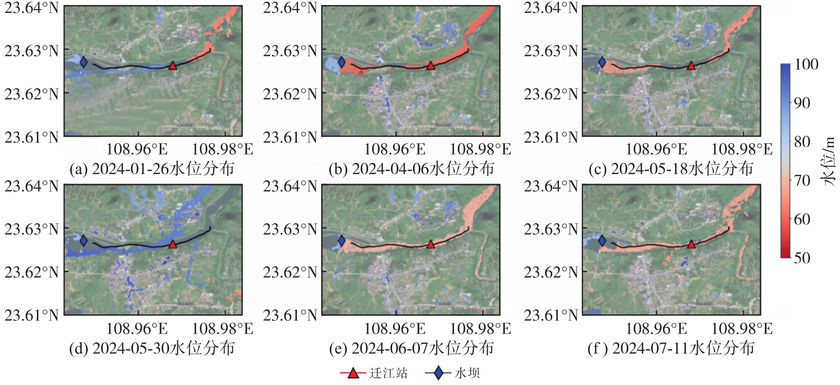
Fig. 10
Phase unwrapping correction results with different integer ambiguities on May 30, 2024"
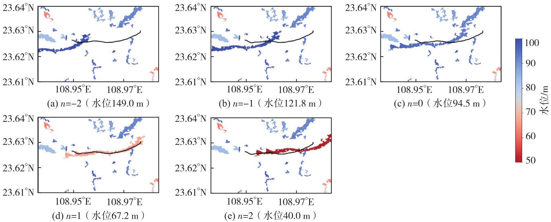
Fig. 11
Distribution of SWOT water level change observation errors for rivers of different widths"
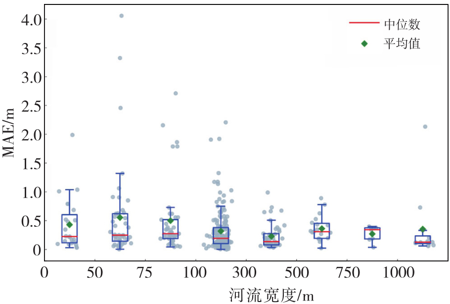
Fig. 12
Spatial distribution of water surface elevation based on SWOT pixel cloud data (Tianhe station)"
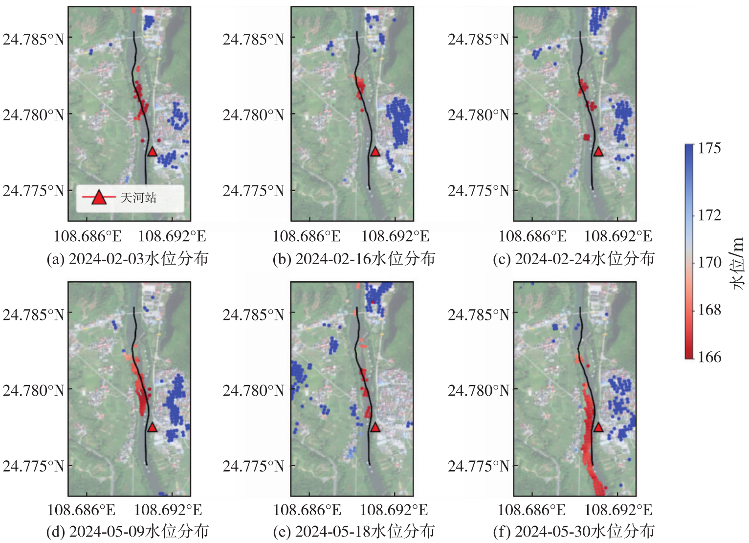
Fig. 13
Water level retrieval results at Tianhe station"
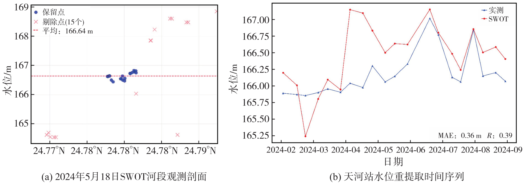
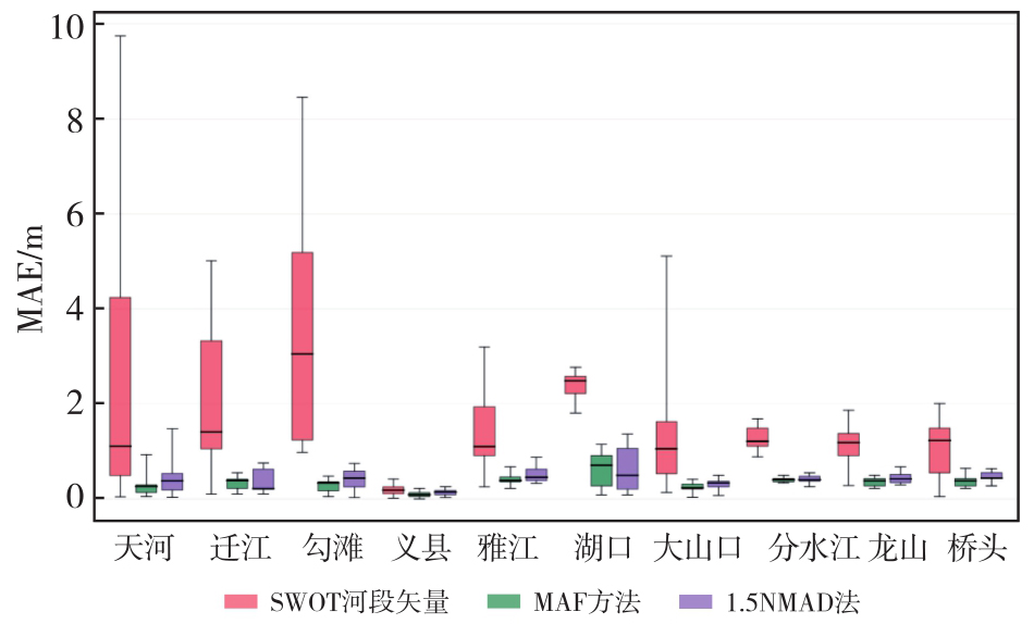
Fig. 14
Comparison of results using different methods"
| [1] | 夏军, 谈戈. 全球变化与水文科学新的进展与挑战[J]. 资源科学, 2002, 24(3): 1-7. |
| Xia Jun, Tan Ge. Hydrological science towards global change: progress and challenge[J]. Resources Science, 2002, 24(3): 1-7. | |
| [2] | Fekete B M, Vörösmarty C J. The current status of global river discharge monitoring and potential new technologies complementing traditional discharge measurements[C]//Proceedings of 2003 PUB Kick-off Meeting, 2003: 129-140. |
| [3] | Hannah D M, Demuth S, Van Lanen H A J, et al. Large-scale river flow archives: importance, current status and future needs[J]. Hydrological Processes, 2011, 25(7): 1191-1200. |
| [4] | Crochemore L, Isberg K, Pimentel R, et al. Lessons learnt from checking the quality of openly accessible river flow data worldwide[J]. Hydrological Sciences Journal, 2020, 65(5): 699-711. |
| [5] | Coleman R. Satellite altimetry and earth sciences: a handbook of techniques and applications[J]. Eos, Transactions American Geophysical Union, 2001, 82(34): 376. |
| [6] | Stammer D, Cazenave A. Satellite altimetry over oceans and land surfaces[M]. Boca Raton: Taylor & Francis, 2017. |
| [7] | Abdalla S, Abdeh Kolahchi A, Ablain M, et al. Altimetry for the future: building on 25 years of progress[J]. Advances in Space Research, 2021, 68(2): 319-363. |
| [8] |
单杰, 田祥希, 李爽, 等. 星载激光测高技术进展[J]. 测绘学报, 2022, 51(6): 964-982. DOI: .
doi: 10.11947/j.AGCS.2022.20220174 |
|
Shan Jie, Tian Xiangxi, Li Shuang, et al. Advances of spaceborne laser altimetry technology[J]. Acta Geodaetica et Cartographica Sinica, 2022, 51(6): 964-982. DOI: .
doi: 10.11947/j.AGCS.2022.20220174 |
|
| [9] | 许可, 蒋茂飞. 海洋卫星雷达测高技术进展[J]. 空间科学学报, 2023, 43(6): 1036-1057. |
| Xu Ke, Jiang Maofei. Advance in ocean satellite radar altimetry technology[J]. Chinese Journal of Space Science, 2023, 43(6): 1036-1057. | |
| [10] | 史卓琳, 黄昌. 河流水情要素遥感研究进展[J]. 地理科学进展, 2020, 39(4): 670-684. |
| Shi Zhuolin, Huang Chang. Recent advances in remote sensing of river characteristics[J]. Progress in Geography, 2020, 39(4): 670-684. | |
| [11] | Pham H T, Marshall L, Johnson F, et al. Deriving daily water levels from satellite altimetry and land surface temperature for sparsely gauged catchments: a case study for the Mekong river[J]. Remote Sensing of Environment, 2018, 212: 31-46. |
| [12] | Biancamaria S, Lettenmaier D P, Pavelsky T M. The SWOT mission and its capabilities for land hydrology[J]. Surveys in Geophysics, 2016, 37(2): 307-337. |
| [13] | 俞昊天, 李国元. “地表水和海洋地形”卫星进展[J]. 国际太空, 2023(1): 32-37. |
| Yu Haotian, Li Guoyuan. Progress of “surface water and ocean topography” satellite[J]. Space International, 2023(1): 32-37. | |
| [14] | Domeneghetti A, Schumann G J P, Frasson R P M, et al. Characterizing water surface elevation under different flow conditions for the upcoming SWOT mission[J]. Journal of Hydrology, 2018, 561: 848-861. |
| [15] | Yu Linpeng, Zhang Haowei, Gong Wei, et al. Validation of mainland water level elevation products from SWOT satellite[J]. IEEE Journal of Selected Topics in Applied Earth Observations and Remote Sensing, 2024, 17: 13494-13505. |
| [16] | Yao Jiaqi, Xu Nan, Wang Mengran, et al. SWOT satellite for global hydrological applications: accuracy assessment and insights into surface water dynamics[J]. International Journal of Digital Earth, 2025, 18(1): 2472924. |
| [17] | Hamoudzadeh A, Ravanelli R, Crespi M. SWOT level 2 lake single-pass product: the L2_HR_LakeSP data preliminary analysis for water level monitoring[J]. Remote Sensing, 2024, 16(7): 1244. |
| [18] | Maubant L, Dodd L, Tregoning P. Assessing the accuracy of SWOT measurements of water bodies in Australia[J]. Geophysical Research Letters, 2025, 52(6): 11. |
| [19] | Normandin C, Frappart F, Baghdadi N, et al. First results of the surface water ocean topography (SWOT) observations to rivers elevation profiles in the Cuvette Centrale of the Congo Basin[J]. Frontiers in Remote Sensing, 2024, 5: 1466695. |
| [20] | He Zhiyue, Cai Yu, Wu Suhui, et al. Evaluation of SWOT's performance for river water level retrieval in the Yangtze River Basin[J]. International Journal of Remote Sensing, 2025, 46(12): 4736-4763. |
| [21] | Zhao Yao, Fu Jun'e, Pang Zhiguo, et al. Validation of inland water surface elevation from SWOT satellite products: a case study in the middle and lower reaches of the Yangtze River[J]. Remote Sensing, 2025, 17(8): 1330. |
| [22] | Bazzi H, Baghdadi N, Ngo Y N, et al. Assessing SWOT interferometric SAR altimetry for inland water monitoring: insights from Lake Léman[J]. Frontiers in Remote Sensing, 2025, 6: 1572114. |
| [23] | 长江水利委员会. 长江流域及西南诸河水资源公报(1998—2016)[R]. 武汉: 长江水利委员会, 1999-2017. |
| Changjiang Water Resources Commission. Water resources bulletin of Yangtze River Basin and southwest rivers (1998—2016)[R]. Wuhan: Changjiang Water Resources Commission, 1999-2017. | |
| [24] | Surface water ocean topography. SWOT level 2 water mask pixel cloud data product, version C[DS/OL]. Jet Propulsion Laboratory: JPL NASA, (2024-02-01) [2025-03-15]. https://doi.org/10.5067/SWOT-PIXC-2.0. |
| [25] | Surface water ocean topography. SWOT level 2 river single-pass vector data product, version C[DS/OL]. Jet Propulsion Laboratory: JPL NASA, (2024-02-01) [2025-03-15]. https://doi.org/10.5067/SWOT-RIVERSP-2.0. |
| [26] | Jet Propulsion Laboratory. SWOT product description: level 2 KaRIn high rate water mask pixel cloud product, JPL D-56411, Revision C[R]. Pasadena: Jet Propulsion Laboratory, 2025. |
| [27] | Chen C, Desai S, Picot N. SWOT science data products user handbook: JPL D-109532[R]. Pasadena: Jet Propulsion Laboratory, 2024. |
| [28] | Jet Propulsion Laboratory. SWOT product description document: level 2 KaRIn high rate river single pass vector (L2_HR_RiverSP) data product, JPL D-56413, Revision C[R]. Pasadena: Jet Propulsion Laboratory, 2025. |
| [29] | Jet Propulsion Laboratory. SWOT algorithm theoretical basis document: level 2 KaRIn high rate river single pass (L2_HR_RiverSP) science algorithm software, JPL D-105505[R]. Pasadena: Jet Propulsion Laboratory, 2023. |
| [30] | Fjø rtoft R, Gaudin J M, Pourthié N, et al. KaRIn on SWOT: characteristics of near-nadir ka-band interferometric SAR imagery[J]. IEEE Transactions on Geoscience and Remote Sensing, 2014, 52(4): 2172-2185. |
| [31] | Jet Propulsion Laboratory. SWOT project mission performance and error budget, JPL D-79084, Revision A[R]. Pasadena: Jet Propulsion Laboratory, 2017. |
| [32] | PO. DAAC. SWOT PIXC dataset phase unwrapping on a local machine[EB/OL]. NASA Physical Oceanography Distributed Active Archive Center, 2024 [2025-03-15]. https://podaac.github.io/tutorials/notebooks/datasets/SWOT_PIXC_PhaseUnwrap_localmachine.html. |
| [1] | Hao XU, Nan XU, Huichao XIN, Yue MA, Wei TU, Qingquan LI. A topographic photon extraction method for intertidal zones using ICESat-2 satellite altimeter data [J]. Acta Geodaetica et Cartographica Sinica, 2026, 55(4): 658-672. |
| [2] | Wenyuan ZHANG, Jinsong PENG, Nadu WEI, Yu GAO, Shubi ZHANG. A short-term prediction method for Earth's polar motion using cascaded LSTM networks based on SSA denoising [J]. Acta Geodaetica et Cartographica Sinica, 2026, 55(1): 46-58. |
| [3] | Huiqin WANG, Jiahao LI, Xin LIU, Yongqiang HE, Jia LUO, Bincan LIU. A denoising method for underground pipeline data acquired by ground penetrating radar based on DnNet [J]. Acta Geodaetica et Cartographica Sinica, 2025, 54(8): 1464-1475. |
| [4] | Xiaodong CHEN, Meng YANG, Yuan YUAN, Wei FENG, Jinway HWANG, Min ZHONG. Evaluation of the accuracy and spatial resolution of SWOT_02 marine gravity model in China's offshore regions [J]. Acta Geodaetica et Cartographica Sinica, 2025, 54(6): 1031-1041. |
| [5] | Zhenhe ZHAI, Zhongmiao SUN, Jian MA, Bin GUAN, He HUANG, Mingda OUYANG, Lingyong HUANG, Zhiyong HUANG, Xingchen PAN, Shigeng YUAN, Shengli LIU, Sen LIU. Gravity field inversion from China ocean altimetry tandem satellites data and performance analysis [J]. Acta Geodaetica et Cartographica Sinica, 2025, 54(4): 714-724. |
| [6] | Xiaoran HAN, Yinghai KE, Jinyuan YU, Mengjie ZHAO, Guoqing ZHANG. Accuracy assessment of lake level and area measurement in the Qinghai-Tibet Plateau using simulated SWOT satellite data [J]. Acta Geodaetica et Cartographica Sinica, 2024, 53(5): 823-834. |
| [7] | Yandong GAO, Yikun JIA, Shijin LI, Yu CHEN, Huaizhan LI, Nanshan ZHENG, Shubi ZHANG. The improved max-flow/min-cut weight algorithm for InSAR phase unwrapping [J]. Acta Geodaetica et Cartographica Sinica, 2024, 53(4): 644-652. |
| [8] | HE Yi, YANG Wang, ZHU Qing. An InSAR phase unwrapping method based on R2AU-Net [J]. Acta Geodaetica et Cartographica Sinica, 2024, 53(3): 435-449. |
| [9] | YUE Jiawei, HUANG Qihuan, LIU Hui, MA Zhangfeng. A multi-baseline phase unwrapping method based on a discrete optimization framework [J]. Acta Geodaetica et Cartographica Sinica, 2024, 53(3): 473-481. |
| [10] | SUN Zhongmiao, ZHAI Zhenhe, GUAN Bin, RUAN Rengui, HUANG Lingyong. Preliminary verification of dual-satellite tandem altimetry on board [J]. Acta Geodaetica et Cartographica Sinica, 2024, 53(2): 207-216. |
| [11] | GAO Xianwen, JIN Taoyong, LI Jiancheng. An improved retracker considering spatial and temporal characteristics of inland water level changes for SAR altimetry [J]. Acta Geodaetica et Cartographica Sinica, 2024, 53(2): 217-230. |
| [12] | LI Qianqian, BAO Lifeng, WANG Yong. Analysis of altimetry-derived sea surface observation anomalies for 2022 eruption of Tonga submarine volcano [J]. Acta Geodaetica et Cartographica Sinica, 2024, 53(2): 263-273. |
| [13] | LIU Huanling, YANG Weiran, ZHANG Fang, WEN Hanjiang, HU Minzhang, JIANG Tao, LIN Wenqi, LI Chenxi. Multi-scale analysis of gravity anomaly models in sea area [J]. Acta Geodaetica et Cartographica Sinica, 2024, 53(2): 274-285. |
| [14] | Xukang XIE, Wei LI. Water level extraction algorithm based on adaptive weighting and deviation matching of multi-source satellite altimetry data [J]. Acta Geodaetica et Cartographica Sinica, 2024, 53(11): 2111-2124. |
| [15] | Yandong GAO, Nanshan ZHENG, Yansuo ZHANG, Shijin LI, Huachao YANG, Hefang BIAN, Qiuzhao ZHANG, Shubi ZHANG, Yu TIAN. A phase unwrapping method based on phase quality fusion estimation and information filtering [J]. Acta Geodaetica et Cartographica Sinica, 2024, 53(10): 1910-1919. |
| Viewed | ||||||
|
Full text |
|
|||||
|
Abstract |
|
|||||
