

Acta Geodaetica et Cartographica Sinica ›› 2026, Vol. 55 ›› Issue (1): 169-180.doi: 10.11947/j.AGCS.2026.20250296
• Cartography and Geoinformation • Previous Articles Next Articles
Zhuang SUN1,2( ), Po LIU1,2, Liang ZHAI1,2(), Yu HE3, Zutao ZHANG1
Received:2025-08-12
Revised:2026-01-05
Online:2026-02-13
Published:2026-02-13
Contact:
Liang ZHAI
E-mail:13236856636@163.com;zhailiang@casm.ac.cn
About author:SUN Zhuang (2000—), male, postgraduate, majors in data association of geographic entity. E-mail: 13236856636@163.com
Supported by:CLC Number:
Zhuang SUN, Po LIU, Liang ZHAI, Yu HE, Zutao ZHANG. A self-supervised matching method for polygonal geographic entity based on a three-branch attention network[J]. Acta Geodaetica et Cartographica Sinica, 2026, 55(1): 169-180.
Fig. 1
The self-supervised matching framework"
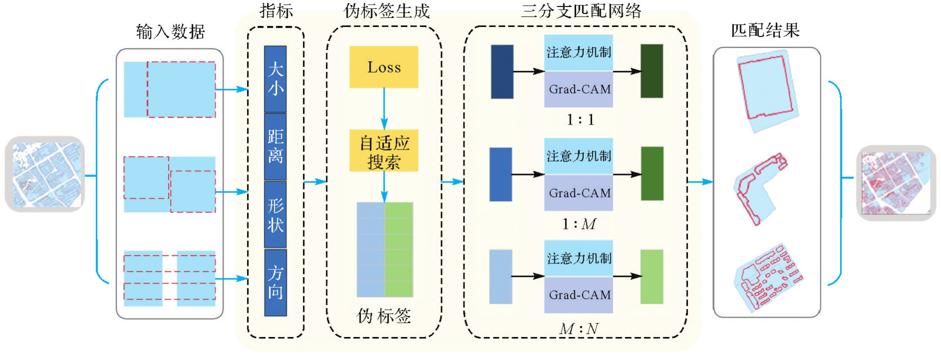
Fig. 2
Decision threshold screening"
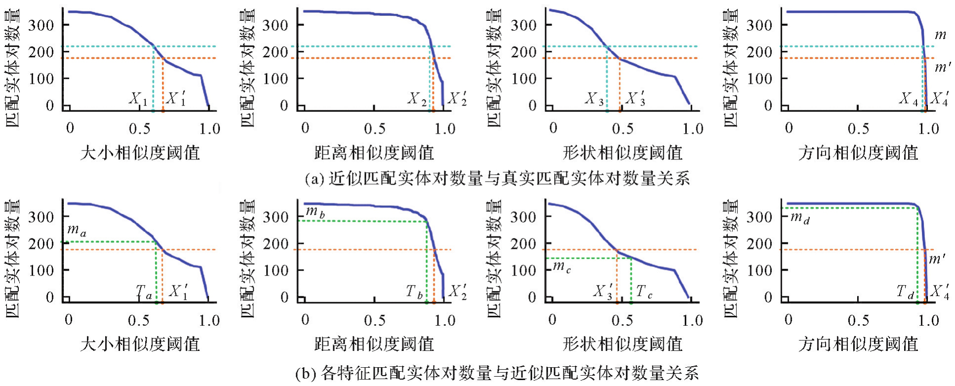
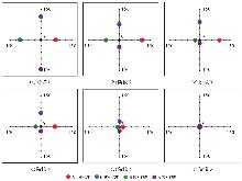
Fig. 3
Loss function optimization"

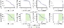
Fig. 4
The threshold search range"
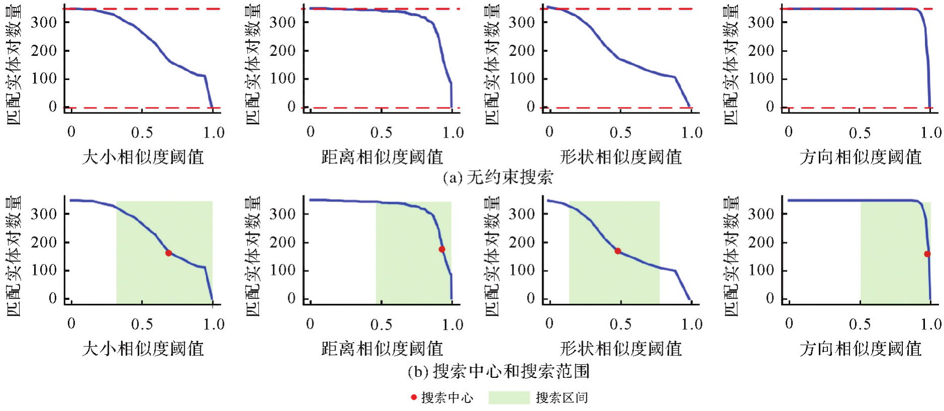
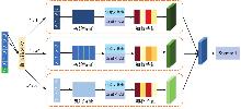
Fig. 5
Three-branch attention network structure"

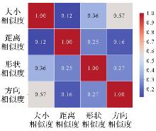
Fig. 6
Indicator correlation"
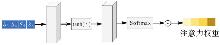
Fig. 7
The attention mechanism"
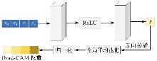
Fig. 8
Grad-CAM feature weight calculation"
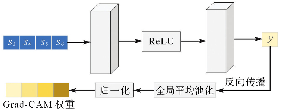
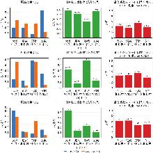
Fig. 9
The feature weights and fusion coefficients under each branch of the gated network"

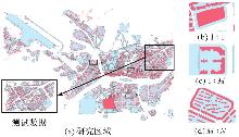
Fig. 10
Study area data sets"

Tab. 1
Overview of the dataset"
| 数据类别 | 训练数据 | 测试数据 |
|---|---|---|
| 自然幢实体数量 | 9094 | 1377 |
| 建筑用地实体数量 | 2343 | 612 |
| 1∶1数量 | 482 | 344 |
| 1∶M数量 | 1325 | 166 |
| M∶N数量 | 24 | 17 |
Tab. 2
Comparison of experimental results"
| 方法 | 匹配关系 | TP | FP | FN | P/(%) | R/(%) | F1值/(%) |
|---|---|---|---|---|---|---|---|
| 经验阈值 | 全部 | 450 | 40 | 37 | 91.84 | 92.40 | 92.12 |
| 1∶1 | 302 | 29 | 13 | 91.24 | 95.87 | 93.50 | |
| 1∶M | 136 | 8 | 22 | 94.44 | 86.08 | 90.07 | |
| M∶N | 12 | 3 | 2 | 80.00 | 85.71 | 82.76 | |
| CatBoost | 全部 | 459 | 23 | 45 | 94.92 | 93.03 | 93.96 |
| 1∶1 | 307 | 11 | 31 | 95.91 | 92.15 | 93.99 | |
| 1∶M | 149 | 10 | 12 | 93.71 | 95.51 | 94.60 | |
| M∶N | 13 | 2 | 2 | 86.67 | 86.67 | 86.67 | |
| BPNN | 全部 | 448 | 46 | 33 | 90.69 | 93.14 | 91.90 |
| 1∶1 | 293 | 26 | 25 | 91.85 | 92.14 | 91.99 | |
| 1∶M | 143 | 17 | 6 | 89.38 | 95.97 | 92.56 | |
| M∶N | 12 | 3 | 2 | 80.00 | 85.71 | 82.76 | |
| 本文方法 | 全部 | 473 | 25 | 29 | 94.98 | 94.22 | 94.60 |
| 1∶1 | 303 | 16 | 25 | 94.98 | 92.38 | 93.66 | |
| 1∶M | 156 | 8 | 2 | 95.12 | 98.73 | 96.89 | |
| M∶N | 14 | 1 | 2 | 93.33 | 87.50 | 90.32 |
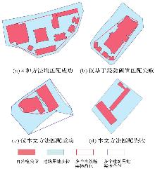
Fig. 11
Qualitative comparison of experimental results"
Fig. 12
Quality of pseudo-labels"
Tab. 3
Calculation results with different label inputs"
| 标签 | 匹配关系 | TP | FP | FN | P/(%) | R/(%) | F1值/(%) |
|---|---|---|---|---|---|---|---|
| 真实标签 | 全部 | 488 | 22 | 17 | 95.69 | 96.63 | 96.16 |
| 1∶1 | 313 | 16 | 15 | 95.14 | 95.43 | 95.28 | |
| 1∶M | 160 | 5 | 1 | 96.97 | 99.38 | 98.16 | |
| M∶N | 15 | 1 | 1 | 93.75 | 93.75 | 93.75 | |
| 伪标签 | 全部 | 473 | 25 | 29 | 94.98 | 94.22 | 94.60 |
| 1∶1 | 303 | 16 | 25 | 94.98 | 92.38 | 93.66 | |
| 1∶M | 156 | 8 | 2 | 95.12 | 98.73 | 96.89 | |
| M∶N | 14 | 1 | 2 | 93.33 | 87.50 | 90.32 |
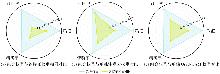
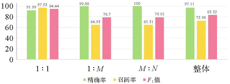
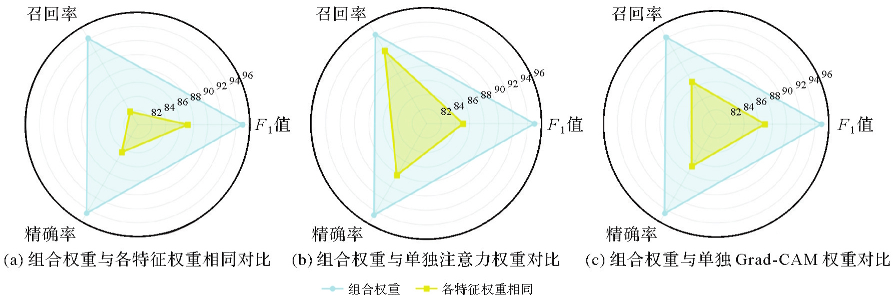
Fig. 13
Comparison of different weight allocation methods"
| [1] | 燕琴, 翟亮, 刘坡. 实景三维中国建设关键技术研究综述[J]. 测绘科学, 2023, 48(7): 1-9. |
| YAN Qin, ZHAI Liang, LIU Po. Review on the key technologies of 3D real scene construction in China[J]. Science of Surveying and Mapping, 2023, 48(7): 1-9. | |
| [2] | 曹全龙, 王会娜, 杜萌, 等. 地理实体模型构建与表达研究[J]. 时空信息学报, 2023, 30(1): 64-69. |
| CAO Quanlong, WANG Huina, DU Meng, et al. Research on construction and representation of geo-entity model[J]. Journal of Spatio-temporal Information, 2023, 30(1): 64-69. | |
| [3] |
黄哲琨, 钱海忠, 蔡中祥, 等. 基于图神经网络的多尺度网状河系分类匹配方法[J]. 测绘学报, 2025, 54(2): 371-384. DOI: .
doi: 10.11947/j.AGCS.2025.20240145 |
|
HUANG Zhekun, QIAN Haizhong, CAI Zhongxiang, et al. A multi-scale mesh river system classification matching method based on graph neural network[J]. Acta Geodaetica et Cartographica Sinica, 2025, 54(2): 371-384. DOI: .
doi: 10.11947/j.AGCS.2025.20240145 |
|
| [4] | 张祖涛, 刘坡, 翟亮, 等. 黄山市地理实体统一标识体系设计与实现[J]. 测绘科学, 2025, 50(6): 157-167. |
| ZHANG Zutao, LIU Po, ZHAI Liang, et al. Design and implementation of unified identification system of basic geographic entity in mount Huangshan city[J]. Journal of Spatio-temporal Information, 2025, 50(6): 157-167. | |
| [5] | FU Z, SUN Y, FAN L, et al. Multiscale and multifeature segmentation of high-spatial resolution remote sensing images using superpixels with mutual optimal strategy[J]. Remote Sensing, 2018, 10(8): 1289. |
| [6] | 郝燕玲, 唐文静, 赵玉新, 等. 基于空间相似性的面实体匹配算法研究[J]. 测绘学报, 2008, 37(4): 501-506. |
| HAO Yanling, TANG Wenjing, ZHAO Yuxin, et al. Polygonal feature matching algorithm based on spatial similarity[J]. Acta Geodaetica et Cartographica Sinica, 2008, 37(4): 501-506. | |
| [7] | 刘坡, 张宇, 龚建华. 中误差和邻近关系的多尺度面实体匹配算法研究[J]. 测绘学报, 2014, 43(4): 419-425. |
| LIU Po, ZHANG Yu, GONG Jianhua. Root mean square error and neighbouring relation matching approach for multi-scale polygonal feature[J]. Acta Geodaetica et Cartographica Sinica, 2014, 43(4): 419-425. | |
| [8] | 石善球. 基于几何与属性匹配的地理信息数据融合更新方法[J]. 自然资源遥感, 2023, 35(1): 251-257. |
| SHI Shanqiu. A geographic data fusion and update method based on geometric and attribute matching[J]. Remote Sensing for Natural Resources, 2023, 35(1): 251-257. | |
| [9] | 赵东保, 盛业华, 张卡. 利用几何矩和叠置分析进行多尺度面要素自动匹配[J]. 武汉大学学报(信息科学版), 2011, 36(11): 1371-1375. |
| ZHAO Dongbao, SHENG Yehua, ZHANG Ka. An algorithm for muti-scale one-to-many polygonal feature matching based on geometry moments and overly analysis[J]. Geomatics and Information Science of Wuhan University, 2011, 36(11): 1371-1375. | |
| [10] |
刘凌佳, 朱道也, 朱欣焰, 等. 基于MBR组合优化算法的多尺度面实体匹配方法[J]. 测绘学报, 2018, 47(5): 652-662. DOI: .
doi: 10.11947/j.AGCS.2018.20160625 |
|
LIU Lingjia, ZHU Daoye, ZHU Xinyan, et al. A multi-scale polygonal object matching method based on MBR combinatorial optimization algorithm[J]. Acta Geodaetica et Cartographica Sinica, 2018, 47(5): 652-662. DOI: .
doi: 10.11947/j.AGCS.2018.20160625 |
|
| [11] | 刘贺, 郭黎, 李豪, 等. 面实体匹配的集成学习CatBoost方法[J]. 地球信息科学学报, 2022, 24(11): 2198-2211. |
| LIU He, GUO Li, LI Hao, et al. Matching polygonal entities with CatBoost ensemble method[J]. Journal of Geo-information Science, 2022, 24(11): 2198-2211. | |
| [12] |
ZHU D, CHENG C, ZHAI W, et al. Multiscale spatial polygonal object granularity factor matching method based on BPNN[J]. ISPRS International Journal of Geo-Information, 2021, 10(2): 75. DOI: .
doi: 10.3390/ijgi/0020075 |
| [13] | FAN Dazhao, DONG Yang, ZHANG Yongsheng. Satellite image matching method based on deep convolutional neural network[J]. Journal of Geodesy and Geoinformation Science, 2019, 2(2): 90-100. |
| [14] |
ALBELWI S. Survey on self-supervised learning: auxiliary pretext tasks and contrastive learning methods in imaging[J]. Entropy, 2022, 24(4): 551. DOI: .
doi: 10.3390/e24040551 |
| [15] | RANI V, NABI S T, KUMAR M, et al. Self-supervised learning: a succinct review[J]. Archives of Computational Methods in Engineering, 2023, 30(4): 2761-2775. |
| [16] | CARON M, BOJANOWSKI P, JOULIN A, et al. Deep clustering for unsupervised learning of visual features[C]//Proceedings of 2018 European conference on computer vision (ECCV). Munich: Springer, 2018: 132-149. |
| [17] | LEE D H. Pseudo-label: the simple and efficient semi-supervised learning method for deep neural networks[C]//Proceedings of 2013 Workshop on Challenges in Representation Learning. Atlanta: ICML.2013, 3(2): 896. |
| [18] | RADFORD A, KIM J W, HALLACY C, et al. Learning transferable visual models from natural language supervision[C]//Proceedings of 2021 International Conference on Machine Learning. [S.l.]: PmLR, 2021: 8748-8763. |
| [19] | ZOU Y, YU Z, KUMAR B V K, et al. Unsupervised domain adaptation for semantic segmentation via class-balanced self-training[C]//Proceedings of 2018 European Conference on Computer Vision (ECCV). Munich: Springer, 2018: 289-305. |
| [20] | LI M, LI Q, WANG Y. Class balanced adaptive pseudo labeling for federated semi-supervised learning[C]//Proceedings of 2023 IEEE/CVF Conference on Computer Vision and Pattern Recognition. Vancouver: IEEE, 2023: 16292-16301. |
| [21] |
TARVAINEN A, VALPOLA H. Mean teachers are better role models: weight-averaged consistency targets improve semi-supervised deep learning results[J]. Advances in Neural Information Processing Systems, 2017: 30. DOI: .
doi: 10.48550/arXiv.1703.01780 |
| [22] | XU M C, ZHOU Y, JIN C, et al. Bayesian pseudo labels: expectation maximization for robust and efficient semi-supervised segmentation[C]//Proceedings of 2022 International Conference on Medical Image Computing and Computer-Assisted Intervention. Cham: Springer Nature Switzerland, 2022: 580-590. |
| [23] | LI L, SHUM H P H, BRECKON T P. Less is more: reducing task and model complexity for 3D point cloud semantic segmentation[C]//Proceedings of 2023 IEEE/CVF Conference on Computer Vision and Pattern Recognition. Vancouver: IEEE, 2023: 9361-9371. |
| [24] | SZEGEDY C, LIU W, JIA Y, et al. Going deeper with convolutions[C]//Proceedings of 2015 IEEE Conference on Computer Vision and Pattern Recognition. Boston: IEEE, 2015: 1-9. |
| [25] | ASLANI S, DAYAN M, STORELLI L, et al. Multi-branch convolutional neural network for multiple sclerosis lesion segmentation[J]. NeuroImage, 2019, 196: 1-15. |
| [26] |
WU J, POLOCZEK M, WILSON A G, et al. Bayesian optimization with gradients[J]. Advances in Neural Information Processing Systems, 2017: 30. DOI: .
doi: 10.48550/arXiv.1703.04389 |
| [27] | FEDUS W, ZOPH B, SHAZEER N. Switch transformers: scaling to trillion parameter models with simple and efficient sparsity[J]. Journal of Machine Learning Research, 2022, 23(120): 1-39. |
| [28] |
WEI R, FAN B, WANG Y, et al. MBNet: multi-branch network for extraction of rural homesteads based on aerial images[J]. Remote Sensing, 2022, 14(10): 2443. DOI: .
doi: 10.3390/rs14102443 |
| [29] | KANUNGO T, MOUNT D M, NETANYAHU N S, et al. An efficient K-means clustering algorithm: analysis and implementation[J]. IEEE Transactions on Pattern Analysis and Machine Intelligence, 2002, 24(7): 881-892. |
| [30] | SELVARAJU R R, COGSWELL M, DAS A, et al. Grad-cam: visual explanations from deep networks via gradient-based localization[C]//Proceedings of 2017 IEEE International Conference on Computer Vision. Venice: IEEE, 2017: 618-626. |
| [1] | Wenjian GAN, Yang ZHOU, Xiaofei HU, Luying ZHAO, Gaoshuang HUANG, Mingbo HOU. Combining projective transform and road segmentation for street view-satellite images cross-view geo-localization [J]. Acta Geodaetica et Cartographica Sinica, 2025, 54(8): 1489-1500. |
| [2] | Qing CHENG, Boxuan WANG, Hongyan ZHANG. DRformer: a progressive coupled multiscale CNN and condensed attention Transformer method for hyperspectral image super-resolution [J]. Acta Geodaetica et Cartographica Sinica, 2025, 54(7): 1230-1242. |
| [3] | Yiming ZHAO, Kelin HU, Kelong TU, Yaxian QING, Chao YANG, Kunlun QI, Huayi WU. Multi-label scene classification method based on fusion of SAR and optical remote sensing images [J]. Acta Geodaetica et Cartographica Sinica, 2025, 54(5): 911-923. |
| [4] | Qingdong WANG, Tengfei WANG, Li ZHANG. Cross-modal contrastive masked autoencoder pre-training for 3D real-scene point cloud [J]. Acta Geodaetica et Cartographica Sinica, 2025, 54(4): 675-687. |
| [5] | Yupeng GU, Wanke LIU, Xiaohong ZHANG, Jie HU, Shujie HU, Weihao LEI, Kai ZHENG. Neural network-based GNSS stochastic model generation method by fisheye images [J]. Acta Geodaetica et Cartographica Sinica, 2025, 54(12): 2206-2218. |
| [6] | Xiong PAN, Zixuan ZHAO, Chang PING, Lihong JIN, Lilong LIU. Ionospheric TEC prediction incorporating semi-parametric and rule-learning [J]. Acta Geodaetica et Cartographica Sinica, 2025, 54(10): 1741-1756. |
| [7] | Yanjun WANG, Xuchao TANG, Cheng WANG, Hengfan CAI. Urban and rural road surface extraction network based on road topological correlation features [J]. Acta Geodaetica et Cartographica Sinica, 2025, 54(1): 75-89. |
| [8] | Liangxiong GONG, Xinghua LI, Yuanming CHENG, Xingyou ZHAO, Renping XIE, Honggen WANG. A lightweight remote sensing images change detection network utilizing spatio-temporal difference enhancement and adaptive feature fusion [J]. Acta Geodaetica et Cartographica Sinica, 2025, 54(1): 136-153. |
| [9] | Jialing LI, Ji QI, Weipeng LU, Chao TAO. Self-supervised learning based urban functional zone classification by integrating optical remote sensing image-OSM data [J]. Acta Geodaetica et Cartographica Sinica, 2025, 54(1): 154-164. |
| [10] | Tao XU, Yuanwei YANG, Xianjun GAO, Zhiwei WANG, Yue PAN, Shaohua LI, Lei XU, Yanjun WANG, Bo LIU, Jing YU, Fengmin WU, Haoyu SUN. Integrated graph convolution and multi-scale features for the overhead catenary system point cloud semantic segmentation [J]. Acta Geodaetica et Cartographica Sinica, 2024, 53(8): 1624-1633. |
| [11] | Yanan JIANG, Linfeng ZHENG, Qiang XU, Minggao TANG, Xing ZHU. Step-like displacement prediction of landslides guided by deformation mechanism [J]. Acta Geodaetica et Cartographica Sinica, 2024, 53(6): 1128-1139. |
| [12] | Daifeng PENG, Chenchen ZHAI, Dingwei ZHOU, Yongjun ZHANG, Haiyan GUAN, Yufu ZANG. High-resolution optical images change detection based on global information enhancement by pyramid semantic token [J]. Acta Geodaetica et Cartographica Sinica, 2024, 53(6): 1195-1211. |
| [13] | Shaopeng DING, Xiushan LU, Rufei LIU, Yi YANG, Haiyan GU, Haitao LI. Building change detection method combining object feature guidance and multiple attention mechanism [J]. Acta Geodaetica et Cartographica Sinica, 2024, 53(6): 1224-1235. |
| [14] | Changqi JI, Zhaojie GUO, Haili SUN, Ruofei ZHONG. Location and rapid detection method of water leakage in subway tunnels based on mobile laser scanning [J]. Acta Geodaetica et Cartographica Sinica, 2024, 53(6): 1236-1250. |
| [15] | Zhanlong CHEN, Xiechun LU, Yongyang XU. A building aggregation method based on deep clustering of graph vertices [J]. Acta Geodaetica et Cartographica Sinica, 2024, 53(4): 736-749. |
| Viewed | ||||||
|
Full text |
|
|||||
|
Abstract |
|
|||||