

Acta Geodaetica et Cartographica Sinica ›› 2026, Vol. 55 ›› Issue (4): 658-672.doi: 10.11947/j.AGCS.2026.20250419
• Coastal and Marine Surveying, Mapping, and Remote Sensing • Previous Articles Next Articles
Hao XU1( ), Nan XU2,3,4,5(), Huichao XIN1, Yue MA6, Wei TU2,3,4,5, Qingquan LI2,3,4,5
Received:2025-10-10
Revised:2026-02-06
Online:2026-05-11
Published:2026-05-11
Contact:
Nan XU
E-mail:231309020016@hhu.edu.cn;xunan2025@szu.edu.cn
About author:XU Hao (2000—), male, postgraduate, majors in remote sensing monitoring of coastal topography. E-mail: 231309020016@hhu.edu.cn
Supported by:CLC Number:
Hao XU, Nan XU, Huichao XIN, Yue MA, Wei TU, Qingquan LI. A topographic photon extraction method for intertidal zones using ICESat-2 satellite altimeter data[J]. Acta Geodaetica et Cartographica Sinica, 2026, 55(4): 658-672.
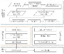
Fig. 1
Photon extraction framework for coastal sandy beaches and tidal flats"
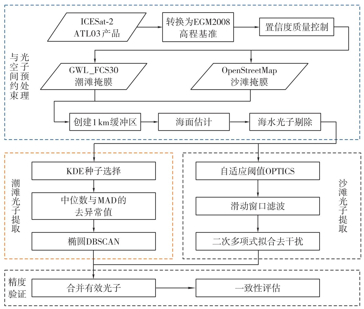
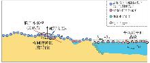
Fig. 2
Tidal flat photon extraction using an adaptive-orientation elliptical DBSCAN method"
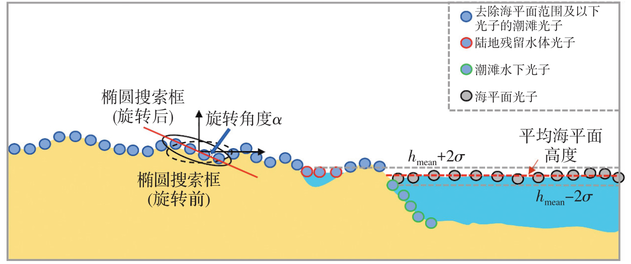
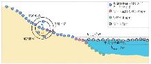
Fig. 3
Sandy beach photon extraction using an adaptive-threshold OPTICS method"
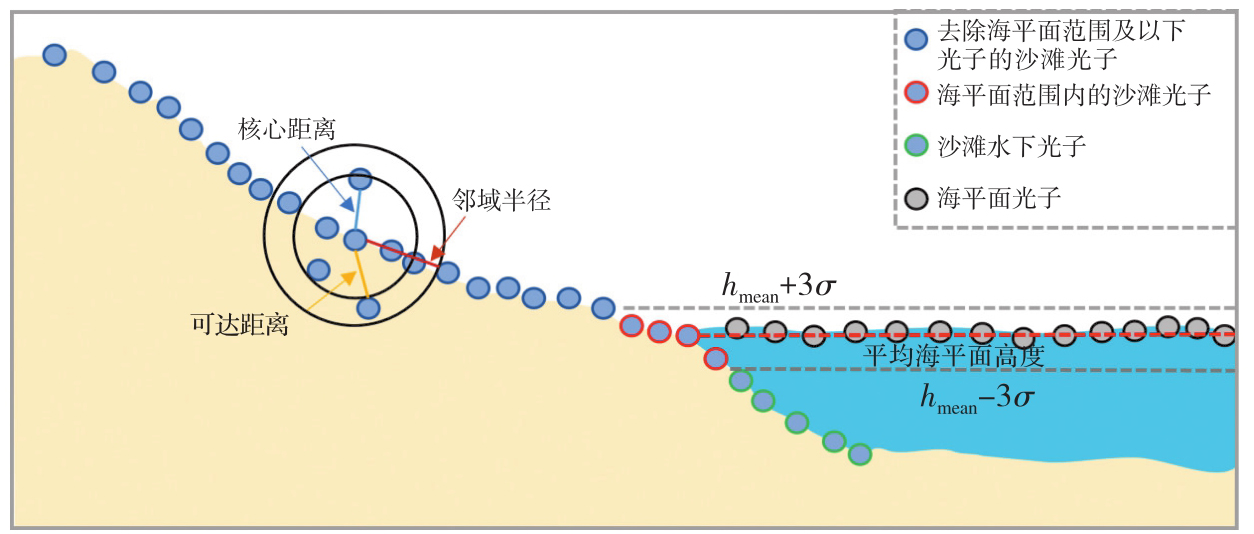
Fig. 4
Accurate extraction of sandy beach photon range using a quadratic polynomial fitting"
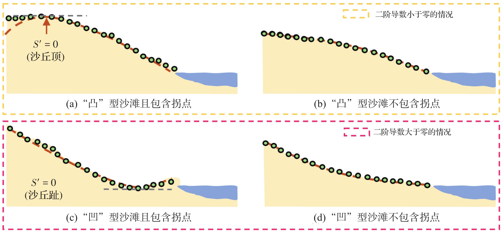
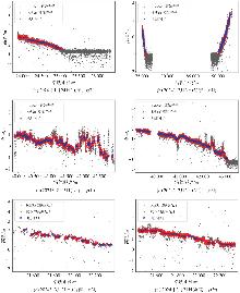
Fig. 5
Photon extraction results of typical tidal flats"
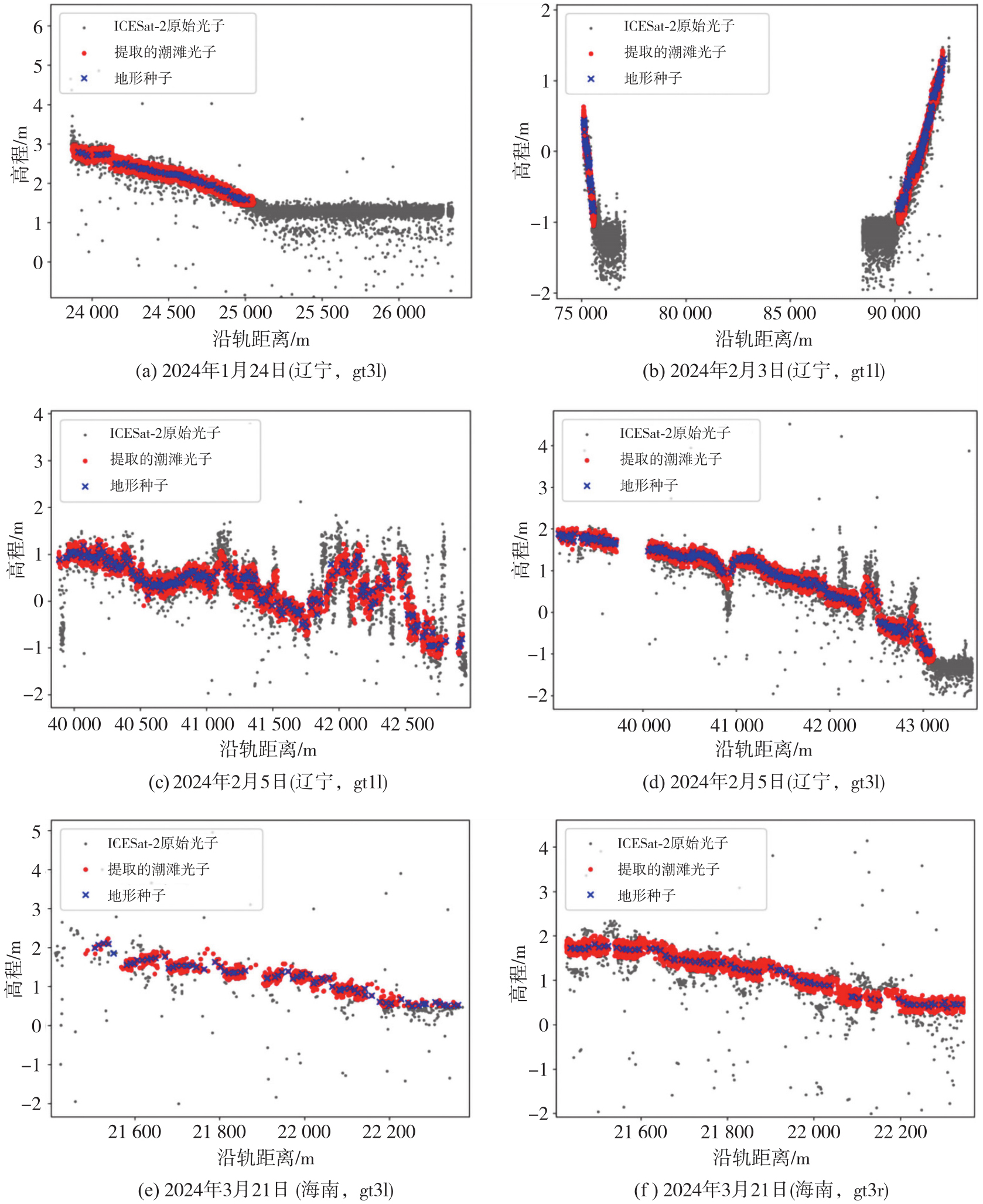
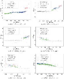
Fig. 6
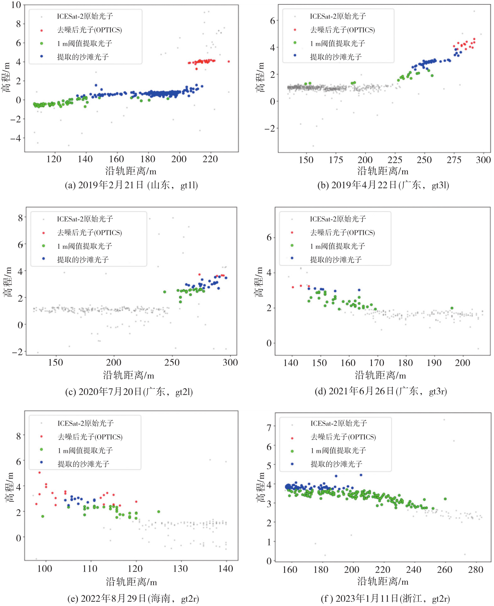
Photon extraction results of typical sandy benches"
Tab. 1
Comparison of terrain information from track profiles"
| 日期 | 区域 | 轨道 | 剖面类型 | 平均高程/m | 平均高差/m | 坡度/(°) | |||
|---|---|---|---|---|---|---|---|---|---|
| 真值 | 提取 | 真值 | 提取 | 真值 | 提取 | ||||
| 2024-01-24 | 辽宁 | gt3l | 潮滩 | 2.096 | 2.167 | 2.115 | 1.527 | 0.035 | 0.063 |
| 2024-02-03 | 辽宁 | gt1l | 潮滩 | -0.091 | 0.033 | 3.056 | 2.479 | 0.001 | 0.001 |
| 2024-02-05 | 辽宁 | gt1l | 潮滩 | 0.321 | 0.344 | 2.715 | 2.525 | 0.027 | 0.026 |
| 2024-02-05 | 辽宁 | gt3l | 潮滩 | 0.695 | 0.748 | 3.464 | 3.237 | 0.039 | 0.039 |
| 2024-03-21 | 海南 | gt3l | 潮滩 | 1.227 | 1.259 | 1.739 | 1.744 | 0.098 | 0.095 |
| 2024-03-21 | 海南 | gt3r | 潮滩 | 1.255 | 1.259 | 1.839 | 1.752 | 0.098 | 0.098 |
| 2019-02-21 | 山东 | gt1l | 沙滩 | 2.959 | 2.810 | 4.004 | 1.939 | 2.553 | 1.671 |
| 2019-04-22 | 广东 | gt3l | 沙滩 | 1.327 | 1.353 | 1.721 | 1.554 | 1.359 | 1.276 |
| 2020-07-20 | 广东 | gt2l | 沙滩 | 2.935 | 2.767 | 2.610 | 1.873 | 1.963 | 1.407 |
| 2021-06-26 | 广东 | gt3r | 沙滩 | 2.678 | 2.482 | 3.396 | 1.179 | 4.170 | 1.445 |
| 2022-08-29 | 海南 | gt2r | 沙滩 | 2.452 | 2.608 | 4.451 | 1.438 | 4.603 | 3.519 |
| 2023-01-11 | 浙江 | gt2r | 沙滩 | 3.338 | 3.477 | 1.881 | 1.738 | 0.694 | 0.535 |
Tab. 2
Accuracy assessment and terrain parameter statistics"
| 类型 | N | 精确率 | 召回率 | F1值 | Kappa系数 | 1 m阈值Kappa系数 | 平均高程/m | 1 m阈值平均高程/m | 平均高差/m | 1 m阈值平均高差/m | 平均坡度/(°) | 1 m阈值平均坡度/(°) | |||
|---|---|---|---|---|---|---|---|---|---|---|---|---|---|---|---|
| 真值 | 提取 | 真值 | 提取 | 真值 | 提取 | ||||||||||
| 潮滩 | 40 852 | 0.995 | 0.911 | 0.951 | 0.889 | - | 0.917 | 0.969 | - | 2.488 | 2.211 | - | 0.055 | 0.054 | - |
| 沙滩 | 4066 | 0.973 | 0.807 | 0.889 | 0.874 | 0.669 | 2.615 | 2.583 | 2.340 | 3.011 | 1.620 | 0.979 | 2.557 | 1.642 | 0.806 |
| 总体 | 44 918 | 0.995 | 0.909 | 0.950 | 0.895 | - | 1.766 | 1.776 | - | 2.749 | 1.915 | - | 1.306 | 0.848 | - |
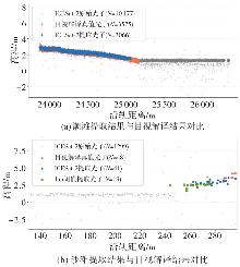
Fig. 7
Typical case comparison between ICESat-2 extraction results and visual interpretation results"
Fig. 8
Confusion matrix for tidal flats, sandy beaches, and the overall scene"
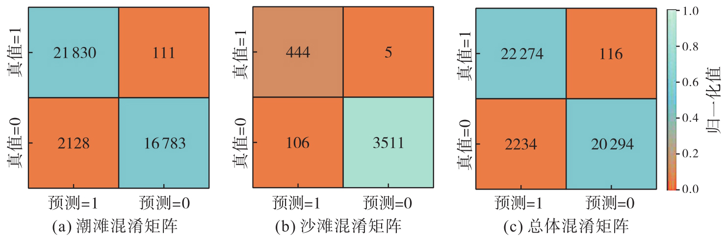
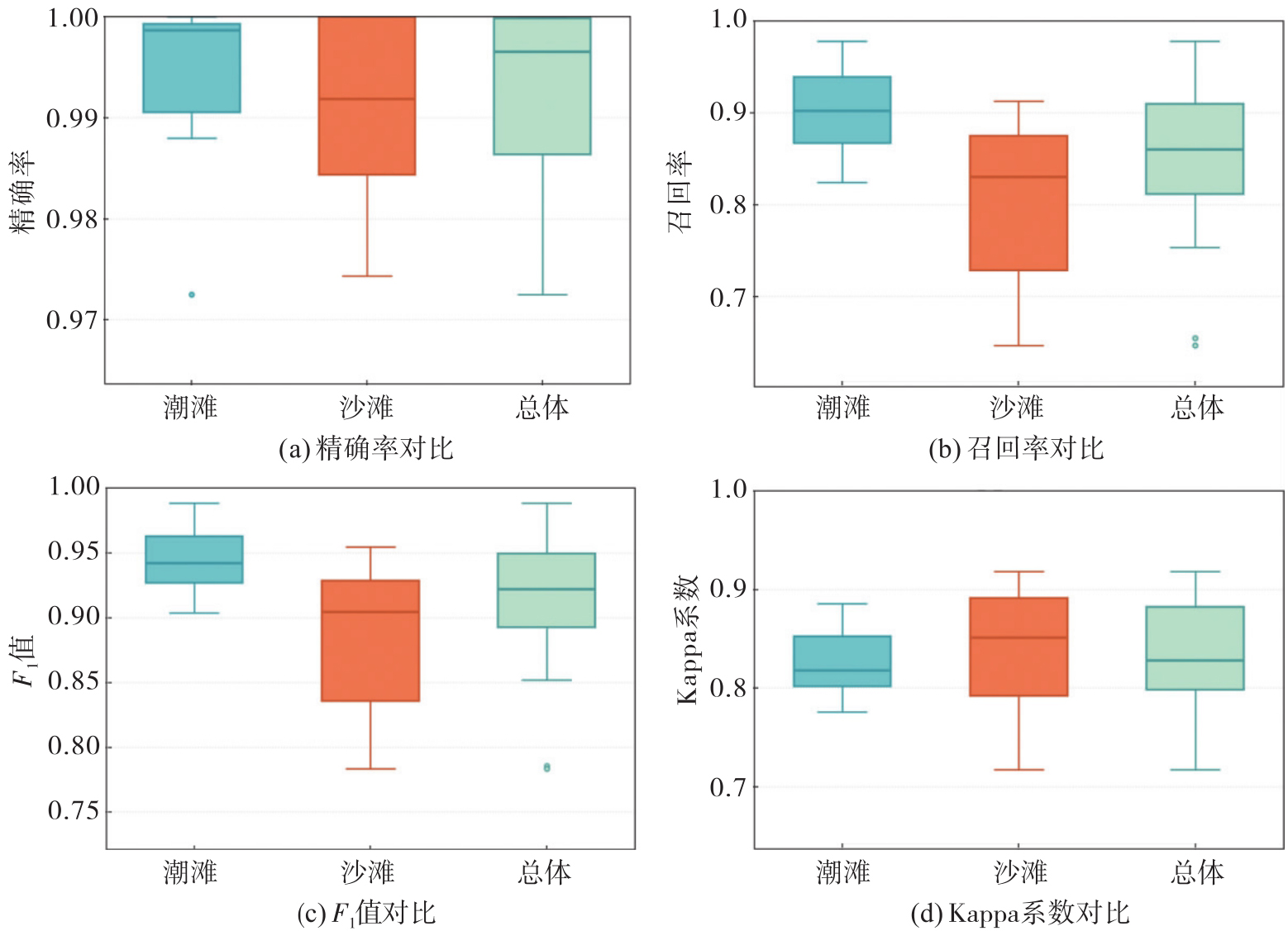
Fig. 9
Box plots of evaluation metrics for tidal flats, sandy beaches, and the overall scene"
| [1] | SCHUERCH M, SPENCER T, TEMMERMAN S, et al. Future response of global coastal wetlands to sea-level rise[J]. Nature, 2018, 561(7722): 231-234. |
| [2] | MURRAY N J, PHINN S R, DEWITT M, et al. The global distribution and trajectory of tidal flats[J]. Nature, 2019, 565(7738): 222-225. |
| [3] | VOUSDOUKAS M I, RANASINGHE R, MENTASCHI L, et al. Sandy coastlines under threat of erosion[J]. Nature Climate Change, 2020, 10(3): 260-263. |
| [4] | CHEN Chunpeng, ZHANG Ce, TIAN Bo, et al. Tide2Topo: a new method for mapping intertidal topography accurately in complex estuaries and bays with time-series Sentinel-2 images[J]. ISPRS Journal of Photogrammetry and Remote Sensing, 2023, 200: 55-72. |
| [5] | 王子赫, 康彦彦, 王敏京. ICESat-2与多源光学影像的潮滩地形反演方法[J]. 测绘通报, 2023(5): 51-55, 61. |
| WANG Zihe, KANG Yanyan, WANG Minjing. ICESat-2 and multivariate optical image for tidal flat topography inversion methods[J]. Bulletin of Surveying and Mapping, 2023(5): 51-55, 61. | |
| [6] | HOOIJER A, VERNIMMEN R. Global LiDAR land elevation data reveal greatest sea-level rise vulnerability in the tropics[J]. Nature Communications, 2021, 12: 3592. |
| [7] | NICHOLLS R J, LINCKE D, HINKEL J, et al. A global analysis of subsidence, relative sea-level change and coastal flood exposure[J]. Nature Climate Change, 2021, 11(4): 338-342. |
| [8] | 方佳毅, 史培军. 全球气候变化背景下海岸洪水灾害风险评估研究进展与展望[J]. 地理科学进展, 2019, 38(5): 625-636. |
| FANG Jiayi, SHI Peijun. A review of coastal flood risk research under global climate change[J]. Progress in Geography, 2019, 38(5): 625-636. | |
| [9] | QU Ying, JEVREJEVA S, JACKSON L P, et al. Coastal sea level rise around the China Seas[J]. Global and Planetary Change, 2019, 172: 454-463. |
| [10] | YU Peiheng, OU Yifu, CHEN Yiyun, et al. Nature-based solutions in coastal urbanization: addressing environmental and socio-economic challenges[J]. Earth Critical Zone, 2026, 3(1): 100032. |
| [11] | 李清泉, 卢艺, 胡水波, 等. 海岸带地理环境遥感监测综述[J]. 遥感学报, 2016, 20(5): 1216-1229. |
| LI Qingquan, LU Yi, HU Shuibo, et al. Review of remotely sensed geo-environmental monitoring of coastal zones[J]. Journal of Remote Sensing, 2016, 20(5): 1216-1229. | |
| [12] |
李鹏. 海岸带地理环境雷达遥感监测关键问题研究[J]. 测绘学报, 2021, 50(4): 565. DOI: .
doi: 10.11947/j.AGCS.2021.20200165 |
|
LI Peng. Key issues on coastal geographical environment monitoring with radar remote sensing[J]. Acta Geodaetica et Cartographica Sinica, 2021, 50(4): 565. DOI: .
doi: 10.11947/j.AGCS.2021.20200165 |
|
| [13] | ALMEIDA L P, ALMAR R, BERGSMA E W J, et al. Deriving high spatial-resolution coastal topography from sub-meter satellite stereo imagery[J]. Remote Sensing, 2019, 11(5): 590. |
| [14] | WANG Siyu, REN Zhikun, WU Chuanyong, et al. DEM generation from Worldview-2 stereo imagery and vertical accuracy assessment for its application in active tectonics[J]. Geomorphology, 2019, 336: 107-118. |
| [15] | ZHANG Xiaohan, WANG Lizhe, LI Jun, et al. Satellite-derived sediment distribution mapping using ICESat-2 and SuperDove[J]. ISPRS Journal of Photogrammetry and Remote Sensing, 2023, 202: 545-564. |
| [16] | 谢丛霜, 陈鹏, 潘德炉. 主被动遥感融合辐射传输卷积神经网络水深反演方法[J]. 光子学报, 2024, 53(8): 0801002. |
| XIE Congshuang, CHEN Peng, PAN Delu. Bathymetric inversion method for active-passive remote sensing fused radiative transfer information convolutional neural networks[J]. Acta Photonica Sinica, 2024, 53(8): 0801002. | |
| [17] | 胡琪鑫, 程亮, 楚森森, 等. ICESat-2水深提取方法及其反演应用[J]. 地球物理学报, 2024, 67(3): 997-1012. |
| HU Qixin, CHENG Liang, CHU Sensen, et al. Water depth extraction of ICESat-2 and application to bathymetric inversion[J]. Chinese Journal of Geophysics, 2024, 67(3): 997-1012. | |
| [18] | YAO Jiaqi, XU Nan, WANG Mengran, et al. SWOT satellite for global hydrological applications: accuracy assessment and insights into surface water dynamics[J]. International Journal of Digital Earth, 2025, 18(1): 2472924. |
| [19] | HAINES B J, DESAI S D, BORN G H. The harvest experiment: calibration of the climate data record from TOPEX/Poseidon, Jason-1 and the ocean surface topography mission[J]. Marine Geodesy, 2010, 33(sup1): 91-113. |
| [20] | MADER D, RICHTER K, WESTFELD P, et al. Volumetric nonlinear ortho full-waveform stacking in airborne LiDAR bathymetry for reliable water bottom point detection in shallow waters[J]. ISPRS Journal of Photogrammetry and Remote Sensing, 2023, 204: 145-162. |
| [21] | LIN Yichun, CHENG Yiting, ZHOU Tian, et al. Evaluation of UAV LiDAR for mapping coastal environments[J]. Remote Sensing, 2019, 11(24): 2893. |
| [22] | SCHMELZ W J, PSUTY N P. Application of geomorphological maps and LiDAR to volumetrically measure coastal geomorphological change from Hurricane Sandy at Fire Island National Seashore[J]. Geomorphology, 2022, 408: 108262. |
| [23] | MARKUS T, NEUMANN T, MARTINO A, et al. The ice, cloud, and land elevation satellite-2 (ICESat-2): science requirements, concept, and implementation[J]. Remote Sensing of Environment, 2017, 190: 260-273. |
| [24] | XU Nan, WANG Lin, XU Hao, et al. Deriving accurate intertidal topography for sandy beaches using ICESat-2 data and Sentinel-2 imagery[J]. Journal of Remote Sensing, 2024, 4: 0305. |
| [25] | NEUENSCHWANDER A L, MAGRUDER L A. Canopy and terrain height retrievals with ICESat-2: a first look[J]. Remote Sensing, 2019, 11(14): 1721. |
| [26] | XU Nan, MA Yue, ZHANG Wenhao, et al. Surface-water-level changes during 2003-2019 in Australia revealed by ICESat/ICESat-2 altimetry and Landsat imagery[J]. IEEE Geoscience and Remote Sensing Letters, 2021, 18(7): 1129-1133. |
| [27] | XU Nan, MA Yue, YANG Jian, et al. Deriving tidal flat topography using ICESat-2 laser altimetry and Sentinel-2 imagery[J]. Geophysical Research Letters, 2022, 49(2): e2021GL096813. |
| [28] | ZHENG Xiucheng, ZHOU Bin, LEI Hui, et al. Mapping tidal flat topography using time-series Sentinel-2 images and ICESat-2 data: a case study in Cixi city[J]. Ocean & Coastal Management, 2024, 256: 107278. |
| [29] | WANG Bikang, MA Yi, ZHANG Jingyu, et al. A noise removal algorithm based on adaptive elevation difference thresholding for ICESat-2 photon-counting data[J]. International Journal of Applied Earth Observation and Geoinformation, 2023, 117: 103207. |
| [30] | XIE Congshuang, CHEN Peng, JAMET C, et al. New reference bathymetric point cloud datasets derived from ICESat-2 observations: a case in the Caribbean Sea[J]. IEEE Transactions on Geoscience and Remote Sensing, 2024, 62: 4200824. |
| [31] | 赵向涛, 亓超, 朱建华, 等. 基于箱线图光子去噪模型的浅海无原位遥感水深反演方法[J]. 激光与光电子学进展, 2026, 63(2): 0228002. |
| ZHAO Xiangtao, QI Chao, ZHU Jianhua, et al. Satellite-derived bathymetry method for shallow waters without in-situ data using boxplot-based photon denoising model[J]. Laser & Optoelectronics Progress, 2026, 63(2): 0228002. | |
| [32] | ZHANG Xiao, LIU Liangyun, ZHAO Tingting, et al. GWL_FCS30: a global 30 m wetland map with a fine classification system using multi-sourced and time-series remote sensing imagery in 2020[J]. Earth System Science Data, 2023, 15(1): 265-293. |
| [33] | MA Yue, WANG Lin, XU Nan, et al. Estimating coastal slope of sandy beach from ICESat-2: a case study in Texas[J]. Environmental Research Letters, 2024, 18(4): 044039. |
| [34] | XU Nan, WANG Lin, ZHANG Hansu, et al. Machine learning based estimation of coastal bathymetry from ICESat-2 and Sentinel-2 data[J]. IEEE Journal of Selected Topics in Applied Earth Observations and Remote Sensing, 2024, 17: 1748-1755. |
| [35] | MA Yue, ZHANG Wenhao, SUN Jinyan, et al. Photon-counting lidar: an adaptive signal detection method for different land cover types in coastal areas[J]. Remote Sensing, 2019 11(4): 471. |
| [36] | XU Nan, MA Yue, ZHOU Hui, et al. A method to derive bathymetry for dynamic water bodies using ICESat-2 and GSWD data sets[J]. IEEE Geoscience and Remote Sensing Letters, 2022, 19: 1500305. |
| [1] | Peng LI, Jiahan ZHANG, Zhihan WANG, Houjie WANG, Zhenhong LI. A review of intertidal topography reconstruction methods: current status, challenges and trends [J]. Acta Geodaetica et Cartographica Sinica, 2026, 55(4): 571-587. |
| [2] | Yi GAO, Xin LIU, Daocheng YU, Shaoshuai YA, Shaofeng BIAN, Heping SUN, Jinyun GUO. An automated seamount detection method integrating vertical gravity gradient anomaly and seafloor topographic models [J]. Acta Geodaetica et Cartographica Sinica, 2026, 55(4): 647-657. |
| [3] | Zhibin XING, Shanshan LI, Miao TIAN, Yao MENG, Na YANG, Qian LI, Pinyao CHANG. FFT block-diagonal least square method for constructing spherical harmonic model of earth topography with degree 10 800 [J]. Acta Geodaetica et Cartographica Sinica, 2026, 55(1): 36-45. |
| [4] | Kefu WU, Haiqiang FU, Jianjun ZHU, Qijin HAN, Aichun WANG, Mingxia ZHANG, Zhiwei LI. LT-1 InSAR block adjustment considering the impact of penetration depth in forest areas [J]. Acta Geodaetica et Cartographica Sinica, 2025, 54(6): 1009-1020. |
| [5] | Xiaodong CHEN, Meng YANG, Yuan YUAN, Wei FENG, Jinway HWANG, Min ZHONG. Evaluation of the accuracy and spatial resolution of SWOT_02 marine gravity model in China's offshore regions [J]. Acta Geodaetica et Cartographica Sinica, 2025, 54(6): 1031-1041. |
| [6] | Zhenhe ZHAI, Zhongmiao SUN, Jian MA, Bin GUAN, He HUANG, Mingda OUYANG, Lingyong HUANG, Zhiyong HUANG, Xingchen PAN, Shigeng YUAN, Shengli LIU, Sen LIU. Gravity field inversion from China ocean altimetry tandem satellites data and performance analysis [J]. Acta Geodaetica et Cartographica Sinica, 2025, 54(4): 714-724. |
| [7] | Bang AN, Yaoyao YU, Huan XU, Jinhai YU, Yuwei TIAN. Application of remove-restore method in iterative algorithm for submarine terrain analysis based on gravity anomaly data [J]. Acta Geodaetica et Cartographica Sinica, 2024, 53(8): 1517-1530. |
| [8] | Dujuan MA, Jiangliu XIE, Rui CHEN, Xinyu YAN, Gaofei YIN. Spatial scale effects of grassland phenology on the Qinghai-Tibet Plateau [J]. Acta Geodaetica et Cartographica Sinica, 2024, 53(5): 860-868. |
| [9] | Jun ZHU, Wei PENG, Haiqiang FU, Man OU, Shancheng LEI, Shiping ZHANG. Large-scale TanDEM-X InSAR sub-canopy topography inversion under insufficient observation information [J]. Acta Geodaetica et Cartographica Sinica, 2024, 53(5): 959-966. |
| [10] | WANG Xiaolei, NAN Yang, HE Xiufeng, SONG Minfeng. GNSS-IR retrieval method with consideration of tidal periodicity of sea level [J]. Acta Geodaetica et Cartographica Sinica, 2024, 53(3): 482-492. |
| [11] | SUN Zhongmiao, ZHAI Zhenhe, GUAN Bin, RUAN Rengui, HUANG Lingyong. Preliminary verification of dual-satellite tandem altimetry on board [J]. Acta Geodaetica et Cartographica Sinica, 2024, 53(2): 207-216. |
| [12] | GAO Xianwen, JIN Taoyong, LI Jiancheng. An improved retracker considering spatial and temporal characteristics of inland water level changes for SAR altimetry [J]. Acta Geodaetica et Cartographica Sinica, 2024, 53(2): 217-230. |
| [13] | ZHAI Zhenhe, SUN Zhongmiao, GUAN Bin, MA Jian, LI Duan. An estimation method of seabed topography based on Gauss surface function using ocean gravity data [J]. Acta Geodaetica et Cartographica Sinica, 2024, 53(2): 231-238. |
| [14] | LI Zhen, GUO Jinyun, SUN Zhongmiao, JIA Yongjun, HUANG Lingyong, SUN Heping. Global marine gravity anomalies recovered from multi-beam laser altimeter data of ICESat-2 [J]. Acta Geodaetica et Cartographica Sinica, 2024, 53(2): 252-262. |
| [15] | LI Qianqian, BAO Lifeng, WANG Yong. Analysis of altimetry-derived sea surface observation anomalies for 2022 eruption of Tonga submarine volcano [J]. Acta Geodaetica et Cartographica Sinica, 2024, 53(2): 263-273. |
| Viewed | ||||||
|
Full text |
|
|||||
|
Abstract |
|
|||||