

Acta Geodaetica et Cartographica Sinica ›› 2024, Vol. 53 ›› Issue (11): 2201-2212.doi: 10.11947/j.AGCS.2024.20230587
• Photogrammetry and Remote Sensing • Previous Articles Next Articles
Yinsheng ZHANG1,2,3( ), Ge CHEN2, Xiuxian DUAN1, Junyi TONG2, Mengjiao SHAN2, Huilin SHAN1,2,3()
Received:2023-12-22
Online:2024-12-13
Published:2024-12-13
Contact:
Huilin SHAN
E-mail:yorkzhang@nuist.edu.cn;shanhuilin@nuist.edu.cn
About author:ZHANG Yinsheng (1975—), male, PhD, professor, majors in intelligent image processing and object detection. E-mail: yorkzhang@nuist.edu.cn
Supported by:CLC Number:
Yinsheng ZHANG, Ge CHEN, Xiuxian DUAN, Junyi TONG, Mengjiao SHAN, Huilin SHAN. Landslide image segmentation model based on multi-layer feature information fusion[J]. Acta Geodaetica et Cartographica Sinica, 2024, 53(11): 2201-2212.
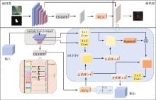
Fig.1
MLFIF-Net structure"
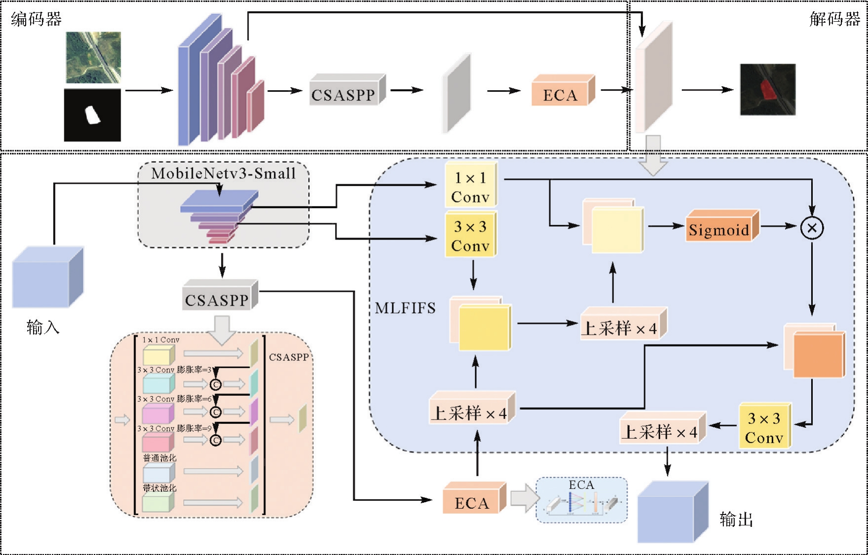

Fig.2
Bottleneck layer structure"
Tab.1
MobileNetv3-Small network parameters"
| 输入尺寸 | 参数 | 输出尺寸 |
|---|---|---|
| 224×224×3 | Conv,3×3 | 112×112×16 |
| 112×112×16 | Bottleneck,3×3 | 56×56×16 |
| 56×56×16 | Bottleneck,3×3 | 28×28×24 |
| 28×28×24 | Bottleneck,3×3 | 28×28×24 |
| 28×28×24 | Bottleneck,5×5 | 14×14×40 |
| 14×14×40 | Bottleneck,5×5 | 14×14×40 |
| 14×14×40 | Bottleneck,5×5 | 14×14×40 |
| 14×14×40 | Bottleneck,5×5 | 14×14×48 |
| 14×14×48 | Bottleneck,5×5 | 14×14×48 |
| 14×14×48 | Bottleneck,5×5 | 7×7×96 |
| 7×7×96 | Bottleneck,5×5 | 7×7×96 |
| 7×7×96 | Bottleneck,5×5 | 7×7×96 |
| 7×7×96 | Conv,1×1 | 7×7×576 |
| 7×7×576 | Pool,7×7 | 1×1×576 |
| 1×1×576 | Conv,1×1 | 1×1×576 |

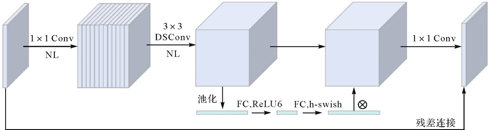
Fig.3
CSASPP module structure"
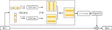
Fig.4
SP structure"
Fig.5
ECA module structure"
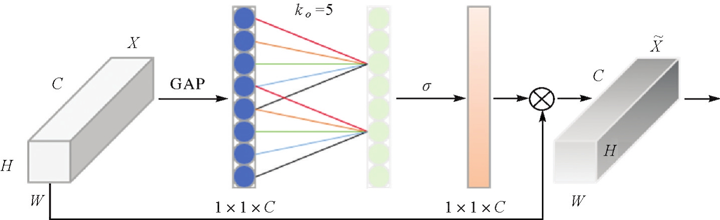
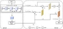
Fig.6
Multi-layer feature information fusion structure"
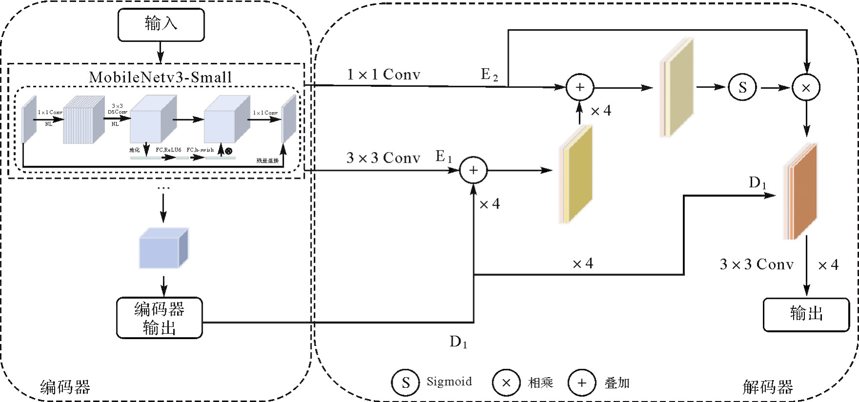
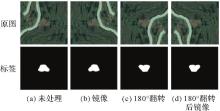
Fig.7
Data enhancement renderings"

Tab.2
Configuration information"
| 配置名称 | 参数 |
|---|---|
| CPU | Intel(R)Core(TM)i9-12900KF |
| GPU | NVIDIA GeForce RTX3090 |
| 操作系统 | Windows10 |
| 框架 | Pytorch1.12 |
| 编程语言 | Python |
Tab.3
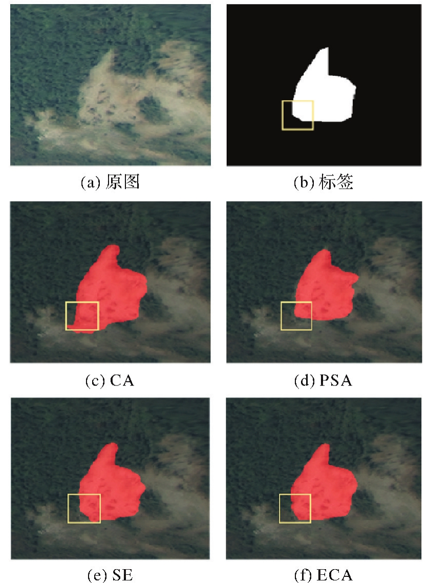
Accuracy of different attention modules"
| 注意力模块 | PA | MPA | MIoU |
|---|---|---|---|
| CA | 96.25 | 95.08 | 87.05 |
| SE | 96.58 | 95.42 | 87.28 |
| PSA | 96.05 | 95.27 | 86.72 |
| ECA | 96.77 | 95.61 | 87.69 |
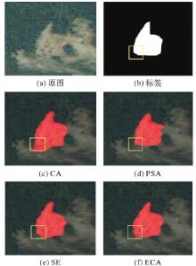
Fig.8
Segmentation results of landslide images using different attention modules"
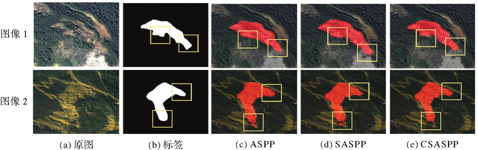
Tab.4
Accuracy of different pyramid pool modules"
| 试验 | 模块 | 膨胀率 | MIoU/(%) |
|---|---|---|---|
| 1 | ASPP | (6,12,18) | 86.62 |
| 2 | ASPP | (3,6,9) | 86.72 |
| 3 | SASPP | (6,12,18) | 86.79 |
| 4 | SASPP | (5,9,13) | 86.84 |
| 5 | SASPP | (3,6,9) | 86.94 |
| 6 | CSASPP | (6,12,18) | 87.35 |
| 7 | CSASPP | (5,9,13) | 87.42 |
| 8 | CSASPP | (3,6,9) | 87.69 |
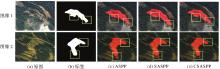
Fig.9
Landslide image segmentation results of different pyramid pooling modules"
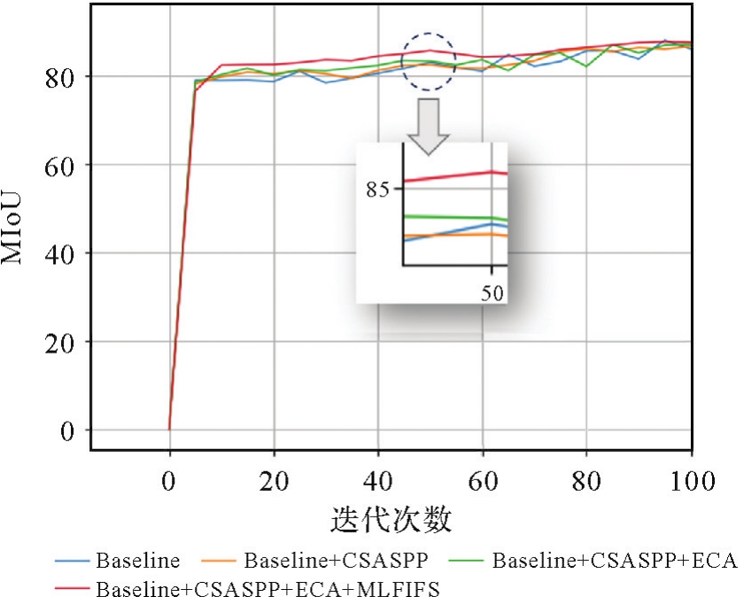
Tab.5
Accuracy of ablation experiments"
| 试验 | 模型 | MIoU/(%) |
|---|---|---|
| 1 | Baseline | 86.15 |
| 2 | Baseline+CSASPP | 86.75 |
| 3 | Baseline+CSASPP+ECA | 87.21 |
| 4 | Baseline+CSASPP+ECA+MLFIFS | 87.69 |

Fig.10
Comparison of MIoU in ablation experiments"
Tab.6
Experimental results of different backbone networks"
| 主干网络 | 推理时间/ms | 帧率 | 参数量 |
|---|---|---|---|
| Vgg16 | 13.52 | 71.24 | 29.3×10⁶ |
| Xception | 35.38 | 28.25 | 55.7×10⁶ |
| MobileNetv3-Small | 12.34 | 80.97 | 6.1×10⁶ |
Tab.7
Accuracy of different network models"
| 模型 | 主干网络 | PA | MPA | MIoU |
|---|---|---|---|---|
| Seg Net | — | 93.14 | 89.43 | 80.85 |
| PSP-Net | Res Net50 | 94.41 | 92.84 | 81.64 |
| E-Deep Lab V3+[ | Efficient Net | 96.54 | 95.42 | 87.25 |
| DA-Net[ | ResNet50 | 96.26 | 95.35 | 86.80 |
| DFPENet[ | ResNet101 | 96.15 | 95.08 | 86.96 |
| HADeen Net[ | Res Net50 | 95.85 | 94.78 | 86.41 |
| MLFIF-Net | MobileNetv3-Small | 96.77 | 95.61 | 87.69 |
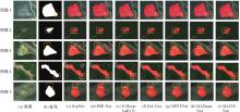
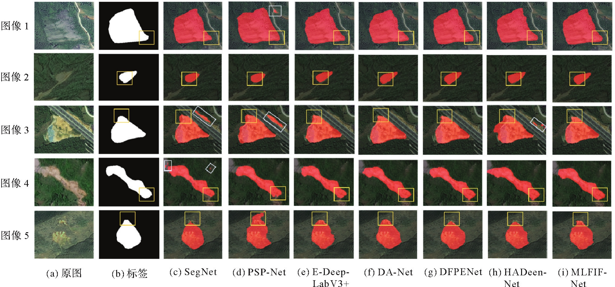
Fig.11
Segmentation results of landslide images from different models"
| [1] | 王岩. 滑坡地质灾害勘查与防治治理研究[J]. 中国高新科技, 2023(14): 92-93. |
| WANG Yan. Research on exploration, prevention and treatment of landslide geological disaster[J]. China High-Tech, 2023(14): 92-93. | |
| [2] | 许强. 对地质灾害隐患早期识别相关问题的认识与思考[J]. 武汉大学学报(信息科学版), 2020, 45(11): 1651-1659. |
| XU Qiang. Understanding and consideration of related issues in early identification of potential geohazards[J]. Geomatics and Information Science of Wuhan University, 2020, 45(11): 1651-1659. | |
| [3] | 马博, 朱杰勇, 刘帅, 等. 联合时序InSAR和滑坡灾害易发性的元阳县滑坡灾害隐患识别[J]. 地质灾害与环境保护, 2023, 34(3): 8-14. |
| MA Bo, ZHU Jieyong, LIU Shuai, et al. Hidden landslide disaster identification in Yuanyang county with combined time-series InSAR and landslide disasters susceptibility[J]. Journal of Geological Hazards and Environment Preservation, 2023, 34(3): 8-14. | |
| [4] | LIU Guang, ZBIGNIEW P, STEFANO S, et al. Land surface displacement geohazards monitoring using multi-temporal InSAR techniques[J]. Journal of Geodesy and Geoinformation Science, 2021, 4(1): 77-87. |
| [5] |
张勤, 白正伟, 黄观文, 等. GNSS滑坡监测预警技术进展[J]. 测绘学报, 2022, 51(10): 1985-2000.DOI:.
doi: 10.11947/j.AGCS.2022.20220299 |
|
ZHANG Qin, BAI Zhengwei, HUANG Guanwen, et al. Review of GNSS landslide monitoring and early warning[J]. Acta Geodaetica et Cartographica Sinica, 2022, 51(10): 1985-2000. DOI:.
doi: 10.11947/j.AGCS.2022.20220299 |
|
| [6] |
黄海峰, 薛蓉花, 赵蓓蓓, 等. 孕灾机理与综合遥感结合的三峡库首顺层岩质滑坡隐患识别[J]. 测绘学报,2022, 51(10): 2056-2068. DOI:.
doi: 10.11947/j.AGCS.2022.20220306 |
|
HUANG Haifeng, XUE Ronghua, ZHAO Beibei, et al. The bedding rock landslide identification in the head area of the Three Gorges Reservoir combined with disaster pregnant mechanism and comprehensive remote sensing method[J]. Acta Geodaetica et Cartographica Sinica, 2022, 51(10): 2056-2068. DOI:.
doi: 10.11947/j.AGCS.2022.20220306 |
|
| [7] | ZHANG Ruixuan, ZHU Wu, LI Zhenhong, et al. Re-Net: multibranch network with structural reparameterization for landslide detection in optical imagery[J]. IEEE Journal of Selected Topics in Applied Earth Observations and Remote Sensing, 2024, 17: 2828-2837. |
| [8] | PRAKASH N, MANCONI A, LOEW S. Mapping landslides on EO data: performance of deep learning modelsvs. traditional machine learning models[J]. Remote Sensing, 2020, 12(3): 346. |
| [9] | LIU Xinran, PENG Yuexing, LU Zili, et al. Feature-fusion segmentation network for landslide detection using high-resolution remote sensing images and digital elevation model data[J]. IEEE Transactions on Geoscience and Remote Sensing, 2023, 61:4500314. |
| [10] | BADRINARAYANAN V, KENDALL A, CIPOLLA R. SegNet: a deep convolutional encoder-decoder architecture for image segmentation[J]. IEEE Transactions on Pattern Analysis and Machine Intelligence, 2017, 39(12): 2481-2495. |
| [11] | ZHAO Hengshuang, SHI Jianping, QI Xiaojuan, et al. Pyramid scene parsing network[C]//Proceedings of 2017 IEEE Conference on Computer Vision and Pattern Recognition. Honolulu: IEEE, 2017: 6230-6239. |
| [12] | CHEN L C, ZHU Yukun, PAPANDREOU G, et al. Encoder-decoder with atrous separable convolution for semantic image segmentation[C]//Proceedings of 2018 European Conference on Computer Vision. Cham: Springer, 2018: 833-851. |
| [13] | GARCIA G P B, SOARES L P, ESPADOTO M, et al. Relict landslide detection using deep-learning architectures for image segmentation in rainforest areas: a new framework[J]. International Journal of Remote Sensing, 2023, 44(7): 2168-2195. |
| [14] | ULLO S, MOHAN A, SEBASTIANELLI A, et al. A new mask R-CNN-based method for improved landslide detection[J]. IEEE Journal of Selected Topics in Applied Earth Observations and Remote Sensing, 2021, 14: 3799-3810. |
| [15] | LIU Peng, WEI Yongming, WANG Qinjun, et al. Research on post-earthquake landslide extraction algorithm based on improved U-Net model[J]. Remote Sensing, 2020, 12(5): 894. |
| [16] | ZHOU Yongxiu, WANG Honghui, YANG Ronghao, et al. A novel weakly supervised remote sensing landslide semantic segmentation method: combining CAM and cycleGAN algorithms[J]. Remote Sensing, 2022, 14(15): 3650. |
| [17] | ZHENG Xiangxiang, HAN Lingyi, HE Guojin, et al. Semantic segmentation model for wide-area coseismic landslide extraction based on embedded multichannel spectral-topographic feature fusion: a case study of the Jiuzhaigou Ms7.0 earthquake in Sichuan, China[J]. Remote Sensing, 2023, 15(4): 1084. |
| [18] | HOWARD A, SANDLER M, CHEN Bo, et al. Searching for MobileNetV3[C]//Proceedings of 2019 IEEE/CVF International Confe-rence on Computer Vision. Seoul: IEEE, 2019: 1314-1324. |
| [19] | SANDLER M, HOWARD A, ZHU Menglong, et al. MobileNetV2: inverted residuals and linear bottlenecks[C]//Proceedings of 2018 IEEE/CVF Conference on Computer Vision and Pattern Recognition. Salt Lake City: IEEE, 2018: 4510-4520. |
| [20] | HU Jie, SHEN Li, ALBANIE S, et al. Squeeze-and-excitation networks[J]. IEEE Transactions on Pattern Analysis and Machine Intelligence, 2020, 42(8): 2011-2023. |
| [21] | HOU Qibin, ZHANG Li, CHENG Mingming, et al. Strip pooling: rethinking spatial pooling for scene parsing[C]//Proceedings of 2020 IEEE/CVF Conference on Computer Vision and Pattern Recognition. Seattle: IEEE, 2020: 4002-4011. |
| [22] | WANG Qilong, WU Banggu, ZHU Pengfei, et al. ECA-Net: efficient channel attention for deep convolutional neural networks[C]//Proceedings of 2020 IEEE/CVF Conference on Computer Vision and Pattern Recognition. Seattle: IEEE, 2020: 11531-11539. |
| [23] | YANG Shuang, WANG Yuzhu, WANG Panzhe, et al. Automatic identification of landslides based on deep learning[J]. Applied Sciences, 2022, 12(16): 8153. |
| [24] | CHANDRA N, SAWANT S, VAIDYA H. An efficient U-Net model for improved landslide detection from satellite images[J]. PFG—Journal of Photogrammetry, Remote Sensing and Geoinformation Science, 2023, 91(1): 13-28. |
| [25] | JI Shunping, YU Dawen, SHEN Chaoyong, et al. Landslide detection from an open satellite imagery and digital elevation model dataset using attention boosted convolutional neural networks[J]. Landslides, 2020, 17(6): 1337-1352. |
| [26] | HOU Qibin, ZHOU Daquan, FENG Jiashi. Coordinate attention for efficient mobile network design[C]//Proceedings of 2021 IEEE/CVF Conference on Computer Vision and Pattern Recognition. Nashville: IEEE, 2021: 13713-13722. |
| [27] | ZHANG Hu, ZU Keke, LU Jian, et al. EPSANet: an efficient pyramid squeeze attention block on convolutional neural network[C]//Proceedings of 2003 Asian Conference on Computer Vision. Cham: Springer, 2023: 541-557. |
| [28] | CHEN Rongjun, YAN Xuanhui, WANG Shiping, et al. DA-Net: dual-attention network for multivariate time series classification[J]. Information Sciences, 2022, 610: 472-487. |
| [29] | GAO Ouyang, NIU Chaoyang, LIU Wei, et al. E-DeepLabV3+: a landslide detection method for remote sensing images[C]//Procee-dings of the 10th Joint International Information Technology and Artificial Intelligence Conference. Chongqing: IEEE, 2022: 573-577. |
| [30] | XU Qingsong, OUYANG Chaojun, JIANG Tianhai, et al. DFPENet-geology: a deep learning framework for high precision recognition and segmentation of co-seismic landslides[EB/OL]. [2023-12-01].https://arxiv.org/abs/1908.10907v3. |
| [31] | YU Bo, XU Chong, CHEN Fang, et al. HADeenNet: a hierarchical-attention multi-scale deconvolution network for landslide detection[J]. International Journal of Applied Earth Observation and Geoinformation, 2022, 111: 102853. |
| [1] | Zejiao WANG, Longgang XIANG, Meng WANG, Xingjuan WANG, Qing LIU. Hierarchical feature and diversified attention fusion network for collaborative extraction of road surface and centerline [J]. Acta Geodaetica et Cartographica Sinica, 2026, 55(3): 548-563. |
| [2] | Shunping JI, Jin LIU, Jian GAO, Jianya GONG. An intelligent 3D reconstruction framework via deep learning based multi-view image matching [J]. Acta Geodaetica et Cartographica Sinica, 2025, 54(9): 1633-1646. |
| [3] | Wei QU, Rongtang XU, Jiuyuan LI, Xingyou TANG, Peinan CHEN. Singular value decomposition normalization prediction method for non-steady landslide displacement [J]. Acta Geodaetica et Cartographica Sinica, 2025, 54(9): 1647-1663. |
| [4] | Feifei TANG, Junzhe ZHOU, Changhan WANG, Jianyun WANG, Yutao ZHOU, Yafei HAO. Quantitative analysis method for the time lag effect of rainfall-reservoir water level-landslide deformation [J]. Acta Geodaetica et Cartographica Sinica, 2025, 54(9): 1687-1696. |
| [5] | Yakun XIE, Yaoji ZHAO, Jiaxing TU, Ruifeng XIA, Dejun FENG, Suning LIU, Hongyu CHEN, Jun ZHU. Edge and global features integrated network for salient object detection in optical remote sensing images [J]. Acta Geodaetica et Cartographica Sinica, 2025, 54(7): 1265-1279. |
| [6] | Jie WAN, Zhong XIE, Yongyang XU, Liufeng TAO. A U-shaped graph convolution network method for semantic segmentation of vehicle LiDAR point clouds towards urban road scenes [J]. Acta Geodaetica et Cartographica Sinica, 2025, 54(7): 1280-1293. |
| [7] | Chaoyang WANG, Yishao SU, Jiancheng LUO, Xiaodong HU, Liegang XIA. Segmentation method of high-score remote sensing target based on road neighborhood relationship [J]. Acta Geodaetica et Cartographica Sinica, 2025, 54(7): 1294-1304. |
| [8] | Zibo DONG, Jingxue WANG, Lijing BU, Lin FANG, Zhenghui XU. MAFNet: building extraction method from remote sensing images based on multi-scale atrous fusion network [J]. Acta Geodaetica et Cartographica Sinica, 2025, 54(6): 1094-1106. |
| [9] | Haifeng LI, Wang GUO, Mengwei WU, Chengli PENG, Qing ZHU, Yu LIU, Chao TAO. Visual-language joint representation and intelligent interpretation of remote sensing geo-objects: principles, challenges and opportunities [J]. Acta Geodaetica et Cartographica Sinica, 2025, 54(5): 853-872. |
| [10] | Chao WANG, Tianyu CHEN, Tong ZHANG, Tanvir AHMED, Liqiang JI, Tao XIE, Jiajun YANG, Shuai WANG. Multi-sensor optical remote sensing images change detection based on global differential enhancement module and balance penalty loss [J]. Acta Geodaetica et Cartographica Sinica, 2025, 54(5): 873-887. |
| [11] | Yiming ZHAO, Kelin HU, Kelong TU, Yaxian QING, Chao YANG, Kunlun QI, Huayi WU. Multi-label scene classification method based on fusion of SAR and optical remote sensing images [J]. Acta Geodaetica et Cartographica Sinica, 2025, 54(5): 911-923. |
| [12] | Xinchang ZHANG, Ji QI, Chao TAO, Siyang FU, Mingning GUO, Yongjian RUAN. A survey on cloud removal in optical remote sensing images: progress, challenges, and future works [J]. Acta Geodaetica et Cartographica Sinica, 2025, 54(4): 603-620. |
| [13] | Yating LIU, Chuanfa CHEN, Qingxin HE, Kunyu LI. Landslide susceptibility evaluation considering positive and negative sample optimization [J]. Acta Geodaetica et Cartographica Sinica, 2025, 54(2): 308-320. |
| [14] | Zhaoyang HOU, Haowen YAN, Liming ZHANG, Rongjuan MA, Ruitao QU. Zero-watermark copyright protection method for remote sensing images based on coupled neural P system and blockchain [J]. Acta Geodaetica et Cartographica Sinica, 2025, 54(12): 2247-2261. |
| [15] | Xi GONG, Zhanlong CHEN, Hengqiang ZHENG, Sheng HU, Hongyan ZHANG. Remote sensing image scene classification method integrating spatial and semantic information of transferred features [J]. Acta Geodaetica et Cartographica Sinica, 2025, 54(11): 2009-2025. |
| Viewed | ||||||
|
Full text |
|
|||||
|
Abstract |
|
|||||