
Acta Geodaetica et Cartographica Sinica ›› 2026, Vol. 55 ›› Issue (9): 1679-1694.doi: 10.11947/j.AGCS.2026.20260175
• Cartography and Geographic Information • Previous Articles Next Articles
Xiechun Lu1,2,3( ), Peiyang Hou1, Kai Ma1,4, Zhanlong Chen2,3,5, Yongyang Xu5()
Received:2026-05-11
Revised:2026-08-31
Online:2026-10-28
Published:2026-10-28
Contact:
Yongyang Xu
E-mail:luxiechun@ctgu.edu.cn;yongyangxu@cug.edu.cn
About author:Lu Xiechun (1992—), male, PhD, lecturer, majors in intelligent cartography, cartographic generalization, spatio-temporal big data analysis. E-mail: luxiechun@ctgu.edu.cn
Supported by:CLC Number:
Xiechun Lu, Peiyang Hou, Kai Ma, Zhanlong Chen, Yongyang Xu. Building shape encoding model integrating skeleton and contour features[J]. Acta Geodaetica et Cartographica Sinica, 2026, 55(9): 1679-1694.
Fig. 1
The overall architecture of SCSR-Net"
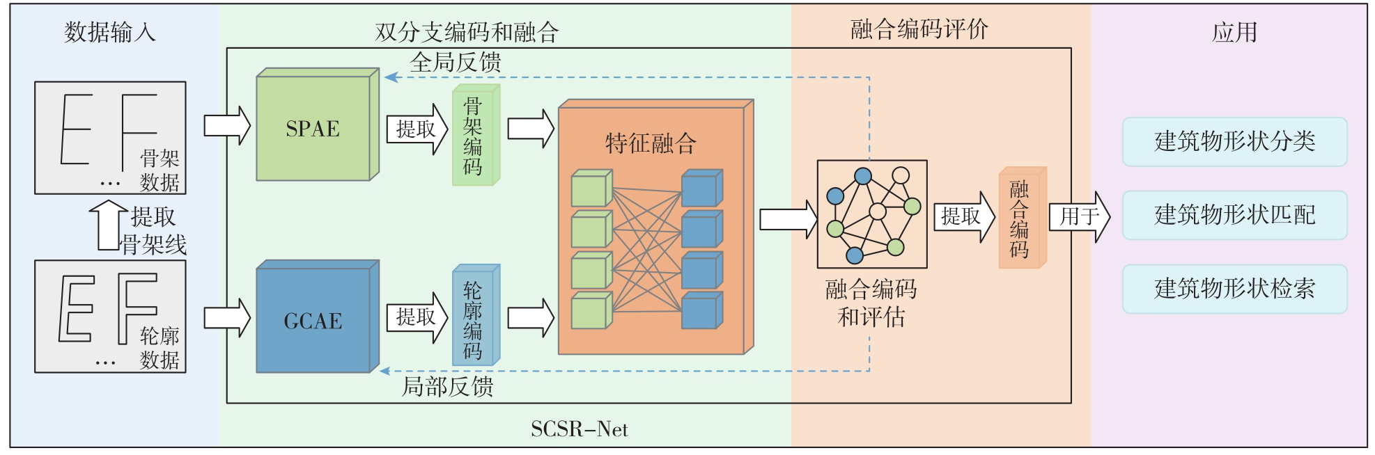
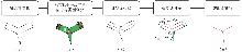
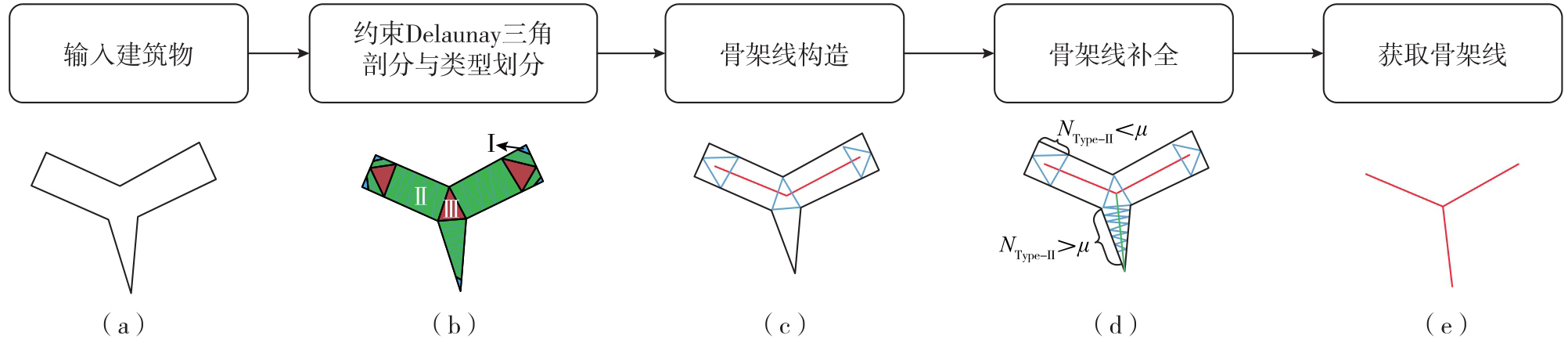
Fig. 2
Skeleton-line construction workflow"
Tab. 1
Features of skeleton lines"
| 特征 | 指标 | 计算公式 | 含义 | 图示 |
|---|---|---|---|---|
| 位置特征 | 横坐标 |  | 其中cx表示建筑物中心点的横坐标;r表示建筑物最大空间跨度 | 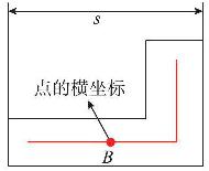 |
纵坐标 |  | 其中cy表示建筑物中心点的纵坐标 | 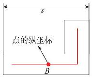 | |
| 结构特征 | 节点的度degi | - | 骨架线顶点的度 | 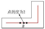 |
| 轮廓关联特征 | 最近距离特征 | 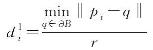 | 其中ƏB表示轮廓点集 | 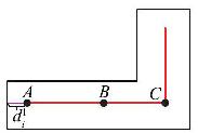 |
次近距离特征 | 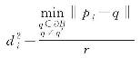 | 其中q′表示最近轮廓点 | 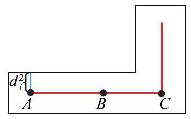 |
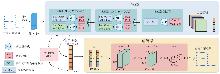
Fig. 3
Architecture of SPAE module"
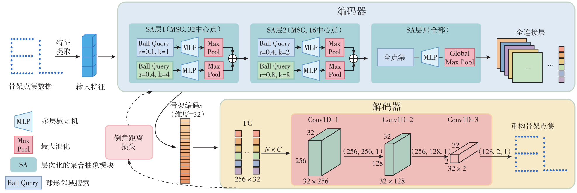
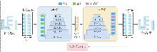
Fig. 4
Architecture of the GCAE module"
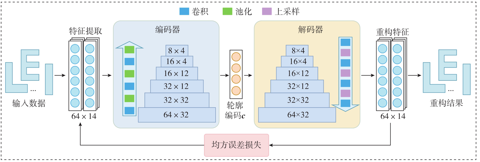
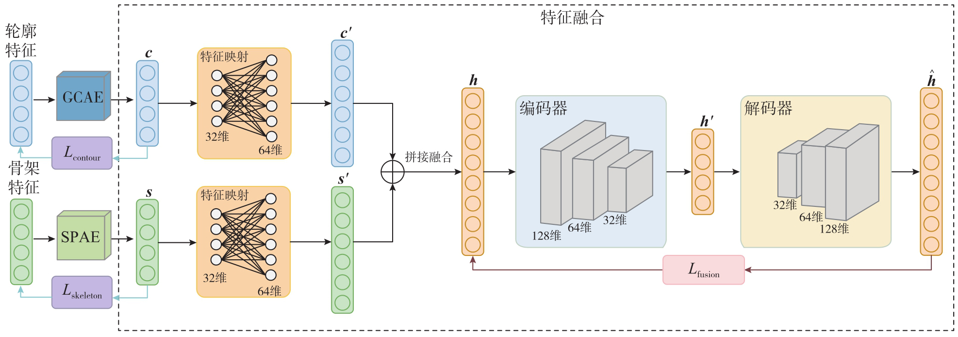
Fig. 5
Fusion module of SCSR-Net feature"
Tab. 2
Example of skeleton lines for 10 building types"
| 类型 | E形 | F形 | H形 | I形 | L形 | O形 | T形 | U形 | Y形 | Z形 |
|---|---|---|---|---|---|---|---|---|---|---|
| 模板 |  |  |  |  |  |  |  |  |  |  |
| 数据 |  |  |  |  |  |  |  |  |  |  |
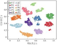
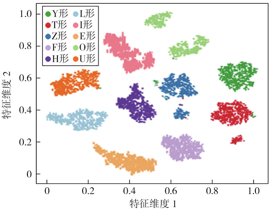
Fig. 6
Visualization results for 10 building types"
Tab. 3
Comparison of shape-matching results obtained by different methods"
| 形状匹配方法 | FT | ST | DCG |
|---|---|---|---|
| 转向函数(TF) | 0.417 | 0.526 | 0.867 |
| 傅里叶描述符(FD) | 0.726 | 0.894 | 0.965 |
| 图编辑距离(GED) | 0.865 | 0.977 | 0.989 |
| 图卷积自编码器(GCAE) | 0.868 | 0.934 | 0.986 |
| LineStringNet模型 | 0.986 | 0.997 | 0.998 |
| 深度聚类形状自编码器(DCSAE) | 0.923 | 0.982 | 0.995 |
| SCSR-Net | 0.968 | 0.995 | 0.998 |
Fig. 7
Building dataset surrounding Tompkins Square Park, New York"
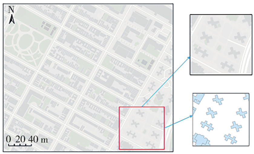
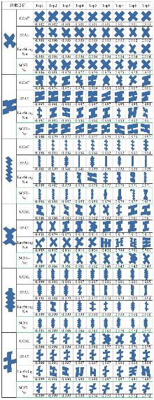
Fig. 8
Building retrieval experiment results"
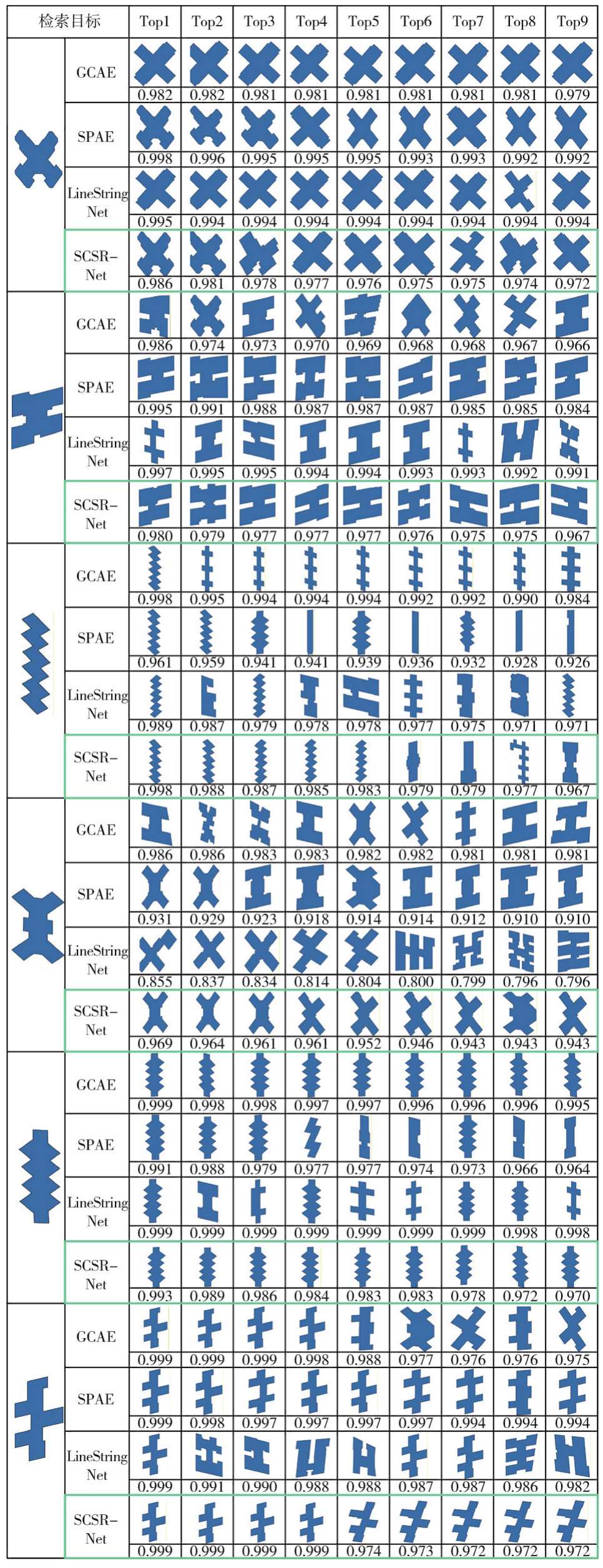
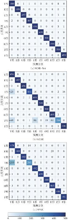
Fig. 9
Comparison of confusion matrices"

Fig. 10
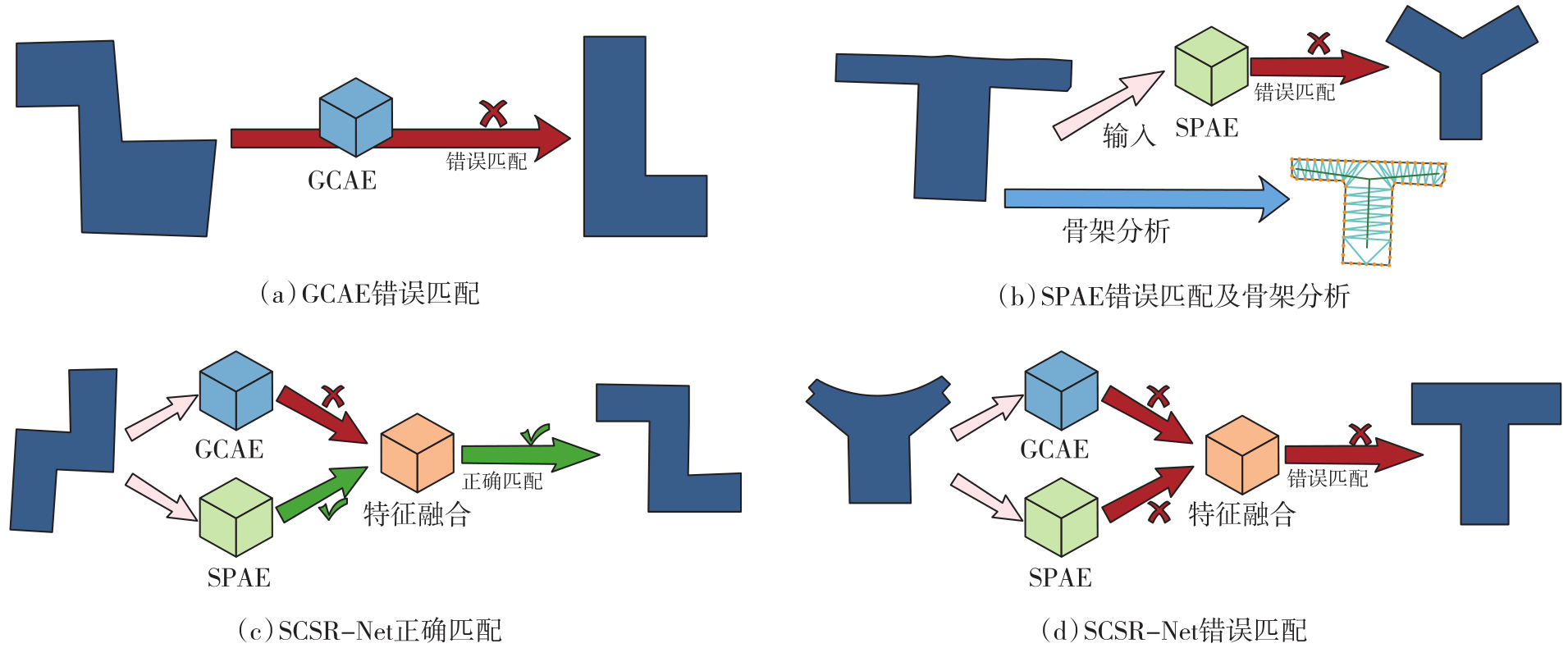
Examples of buildings with partial matching errors"
Tab. 4
Comparative experimental results of different fusion methods"
| 融合方法 | FT | ST | DCG | 匹配准确率/(%) |
|---|---|---|---|---|
| 门控融合(未映射) | 0.835 | 0.966 | 0.985 | 91.12 |
| 注意力机制(未映射) | 0.816 | 0.920 | 0.980 | 91.98 |
| 加权拼接(未映射) | 0.891 | 0.982 | 0.989 | 94.34 |
| 门控融合(映射) | 0.871 | 0.969 | 0.986 | 93.22 |
| 注意力机制(映射) | 0.928 | 0.993 | 0.993 | 94.66 |
| SCSR-Net(映射) | 0.968 | 0.995 | 0.998 | 99.18 |
Tab. 5
Comparative experiments between dynamic and fixed weights"
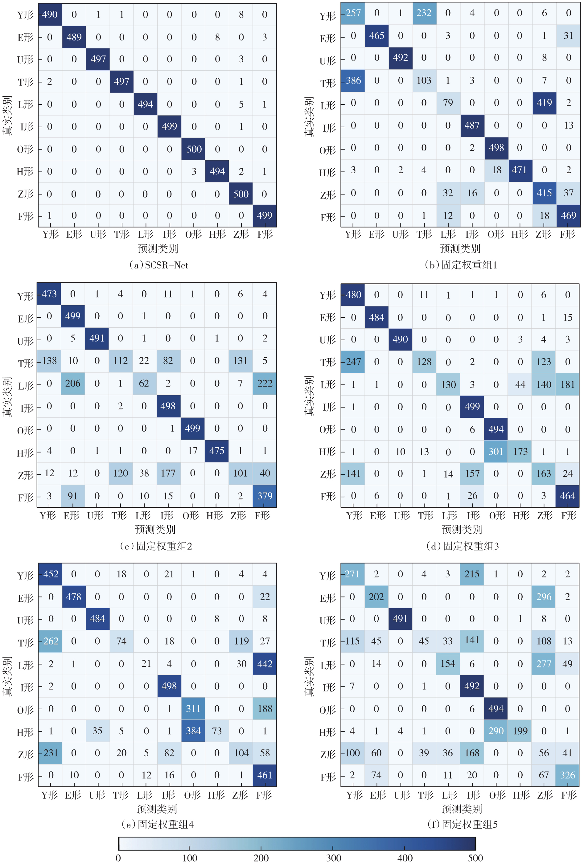
| 权重设计 | α1 | α2 | α3 | FT | ST | DCG | 匹配准确率/(%) |
|---|---|---|---|---|---|---|---|
| SCSR-Net | 动态调整 | 动态调整 | 动态调整 | 0.968 | 0.995 | 0.998 | 99.18 |
| 固定权重组1 | 0.8 | 0.10 | 0.10 | 0.759 | 0.961 | 0.953 | 74.72 |
| 固定权重组2 | 0.7 | 0.15 | 0.15 | 0.738 | 0.892 | 0.950 | 71.78 |
| 固定权重组3 | 0.6 | 0.20 | 0.20 | 0.661 | 0.838 | 0.939 | 70.10 |
| 固定权重组4 | 0.4 | 0.30 | 0.30 | 0.582 | 0.740 | 0.911 | 58.12 |
| 固定权重组5 | 0.3 | 0.35 | 0.35 | 0.536 | 0.734 | 0.899 | 54.60 |
Fig. 11
Comparison of confusion matrices for dynamic and fixed weights"
Tab. 6
Effects of skeleton lines constructed from different contour points on the model"
| 轮廓采样点数/骨架加密点数 | FT | ST | DCG | 匹配准确率/(%) |
|---|---|---|---|---|
| 32/16 | 0.771 | 0.911 | 0.97 | 80.06 |
| 32/32 | 0.748 | 0.944 | 0.972 | 76.24 |
| 32/64 | 0.753 | 0.900 | 0.967 | 78.96 |
| 64/16 | 0.951 | 0.976 | 0.995 | 96.36 |
| 64/32 | 0.968 | 0.995 | 0.998 | 99.18 |
| 64/64 | 0.953 | 0.995 | 0.997 | 97.42 |
| 128/16 | 0.912 | 0.985 | 0.994 | 97.08 |
| 128/32 | 0.951 | 0.993 | 0.997 | 98.80 |
| 128/64 | 0.943 | 0.997 | 0.997 | 97.78 |
Tab. 7
Experimental results for different orders of adjacent contour"
| 阶数 | FT | ST | DCG | 匹配准确率/(%) |
|---|---|---|---|---|
| 一阶 | 0.847 | 0.960 | 0.986 | 95.12 |
| 二阶 | 0.968 | 0.995 | 0.998 | 99.18 |
| 三阶 | 0.855 | 0.954 | 0.987 | 91.56 |
| 四阶 | 0.827 | 0.938 | 0.982 | 89.24 |
Tab. 8
Experimental results under different weight settings"
| λ1 | λ2 | 匹配准确率/(%) | |||||||||
|---|---|---|---|---|---|---|---|---|---|---|---|
| Y形 | E形 | F形 | U形 | T形 | L形 | I形 | O形 | H形 | Z形 | ||
| 0.1 | 0.9 | 95.6 | 92.0 | 98.2 | 98.6 | 63.8 | 98.8 | 99.4 | 99.6 | 96.8 | 98.6 |
| 0.2 | 0.8 | 95.8 | 94.0 | 99.2 | 99.6 | 65.0 | 99.0 | 99.6 | 99.6 | 97.0 | 99.4 |
| 0.3 | 0.7 | 96.2 | 96.2 | 99.6 | 99.6 | 68.2 | 99.4 | 99.8 | 99.6 | 97.8 | 100.0 |
| 0.4 | 0.6 | 97.8 | 96.4 | 99.6 | 99.6 | 92.4 | 99.0 | 99.8 | 99.6 | 98.6 | 100.0 |
| 0.5 | 0.5 | 98.0 | 97.8 | 99.8 | 99.4 | 99.4 | 98.8 | 99.8 | 100.0 | 98.8 | 100.0 |
| 0.6 | 0.4 | 98.0 | 99.4 | 99.8 | 99.0 | 99.2 | 98.8 | 100.0 | 100.0 | 99.2 | 96.0 |
| 0.7 | 0.3 | 97.8 | 99.8 | 99.4 | 96.6 | 98.2 | 98.8 | 100.0 | 100.0 | 98.8 | 79.6 |
| 0.8 | 0.2 | 98.0 | 99.8 | 99.0 | 91.8 | 97.8 | 99.0 | 100.0 | 100.0 | 99.2 | 77.2 |
| 0.9 | 0.1 | 97.6 | 99.6 | 98.8 | 94.6 | 93.8 | 99.0 | 100.0 | 100.0 | 99.2 | 72.0 |
Tab. 9
Experimental results of the SCSR-Net under different δ/K parameter settings"
| δ/K | FT | ST | DCG |
|---|---|---|---|
| 0.001/5 | 0.873 | 0.957 | 0.986 |
| 0.001/10 | 0.892 | 0.962 | 0.989 |
| 0.001/20 | 0.861 | 0.951 | 0.984 |
| 0.0005/5 | 0.953 | 0.993 | 0.997 |
| 0.0005/10 | 0.968 | 0.995 | 0.998 |
| 0.0005/20 | 0.948 | 0.982 | 0.995 |
| 0.0001/5 | 0.927 | 0.980 | 0.994 |
| 0.0001/10 | 0.934 | 0.984 | 0.995 |
| 0.0001/20 | 0.916 | 0.979 | 0.993 |
Tab. 10
Comparison of scale-encoding similarity results for buildings of different sizes"
| 缩放系数 | Y形 | L形 | E形 | U形 | I形 | F形 | O形 | T形 | H形 | Z形 |
|---|---|---|---|---|---|---|---|---|---|---|
| 1∶0.5 | 0.996 1 | 0.995 7 | 0.998 9 | 0.997 7 | 0.999 0 | 0.997 5 | 0.999 7 | 0.997 5 | 0.999 4 | 0.997 7 |
| 1∶2 | 0.990 6 | 0.999 0 | 0.998 6 | 0.998 1 | 0.999 5 | 0.996 9 | 0.999 6 | 0.999 0 | 0.999 2 | 0.998 2 |
| 1∶5 | 0.997 6 | 0.999 4 | 0.996 1 | 0.996 2 | 0.998 9 | 0.995 7 | 0.999 8 | 0.998 7 | 0.998 4 | 0.997 3 |
| 1∶10 | 0.998 7 | 0.999 7 | 0.995 1 | 0.996 3 | 0.999 1 | 0.998 3 | 0.999 7 | 0.997 6 | 0.998 8 | 0.997 2 |
| 1∶20 | 0.997 6 | 0.995 8 | 0.997 2 | 0.997 3 | 0.998 8 | 0.998 1 | 0.999 8 | 0.997 9 | 0.998 3 | 0.997 8 |
| [1] | Batty M. The size, scale, and shape of cities[J]. Science, 2008, 319(5864): 769-771. |
| [2] | Arefi M. Urban transformation: understanding city design and form[J]. Journal of Urban Design, 2011, 16(2): 304-306. |
| [3] | Deng Min, Li Zhilin, Chen Xiaoyong. Extended Hausdorff distance for spatial objects in GIS[J]. International Journal of Geographical Information Science, 2007, 21(4): 459-475. |
| [4] | Ai Tinghua, Cheng Xiaoqiang, Liu Pengcheng, et al. A shape analysis and template matching of building features by the Fourier transform method[J]. Computers, Environment and Urban Systems, 2013, 41: 219-233. |
| [5] | Ballatore A, Bertolotto M, Wilson D C. An evaluative baseline for geo-semantic relatedness and similarity[J]. GeoInformatica, 2014, 18(4): 747-767. |
| [6] | Moradi M, Roche S, Mostafavi M A. A novel GIS-based polygon shape similarity measure applied to OSM building footprints[J]. Advances in Cartography and GIScience of the ICA, 2025, 5: 1-9. |
| [7] | Larson R R. Geographic information retrieval and spatial browsing[C]//Proceedings of the 32nd Clinic on Library Applications of Data Processing. Urbana-Champaign: Graduate School of Library and Information Science, University of Illinois at Urbana-Champaign, 1996: 81-124. |
| [8] | Veltkamp R C, Hagedoorn M. State of the art in shape matching[M]//Lew M S. Principles of Visual Information Retrieval. London: Springer, 2001: 87-119. |
| [9] | Zhang X, Ai T H, Stoter J, et al. Data matching of building polygons at multiple map scales improved by contextual information and relaxation[J]. ISPRS Journal of Photogrammetry and Remote Sensing, 2014, 92: 147-163. |
| [10] | Yan Yuhan, Wu Pengda, Yin Yong, et al. Robust multi-source geographic entities matching by maximizing geometric and semantic similarity[J]. Scientific Reports, 2024, 14(1): 31616. |
| [11] | Yan Haowen. Quantitative relations between spatial similarity degree and map scale change of individual linear objects in multi-scale map spaces[J]. Geocarto International, 2015, 30(4): 472-482. |
| [12] | Yan Xiongfeng, Ai Tinghua, Zhang Xiang. Template matching and simplification method for building features based on shape cognition[J]. ISPRS International Journal of Geo-Information, 2017, 6(8): 250. |
| [13] | Sester M. Cartographic generalization[J]. Journal of Spatial Information Science, 2020(21): 5-11. |
| [14] |
武芳, 巩现勇, 杜佳威. 地图制图综合回顾与前望[J]. 测绘学报, 2017, 46(10): 1645-1664. DOI: .
doi: 10.11947/j.AGCS.2017.20170287 |
|
Wu Fang, Gong Xianyong, Du Jiawei. Overview of the research progress in automated map generalization[J]. Acta Geodaetica et Cartographica Sinica, 2017, 46(10): 1645-1664. DOI: .
doi: 10.11947/j.AGCS.2017.20170287 |
|
| [15] | 钱海忠, 武芳, 朱鲲鹏, 等. 一种基于降维技术的街区综合方法[J]. 测绘学报, 2007, 36(1): 102-107, 118. |
| Qian Haizhong, Wu Fang, Zhu Kunpeng, et al. A generalization method of street block based on dimension-reducing technique[J]. Acta Geodaetica et Cartographica Sinica, 2007, 36(1): 102-107, 118. | |
| [16] | Zahn C T, Roskies R Z. Fourier descriptors for plane closed curves[J]. IEEE Transactions on Computers, 1972, C-21(3): 269-281. |
| [17] | Arkin E M, Chew L P, Huttenlocher D P, et al. An efficiently computable metric for comparing polygonal shapes[J]. IEEE Transactions on Pattern Analysis and Machine Intelligence, 1991, 13(3): 209-216. |
| [18] | Persoon E, Fu K S. Shape discrimination using Fourier descriptors[J]. IEEE Transactions on Systems, Man, and Cybernetics, 1977, 7(3): 170-179. |
| [19] | Zhang Dengsheng, Lu Guojun. Review of shape representation and description techniques[J]. Pattern Recognition, 2004, 37(1): 1-19. |
| [20] | Belongie S, Malik J, Puzicha J. Shape matching and object recognition using shape contexts[J]. IEEE Transactions on Pattern Analysis and Machine Intelligence, 2002, 24(4): 509-522. |
| [21] | Latecki L J, Lakamper R. Shape similarity measure based on correspondence of visual parts[J]. IEEE Transactions on Pattern Analysis and Machine Intelligence, 2000, 22(10): 1185-1190. |
| [22] |
晏雄锋, 艾廷华, 杨敏, 等. 地图空间形状认知的自编码器深度学习方法[J]. 测绘学报, 2021, 50(6): 757-765. DOI: .
doi: 10.11947/j.AGCS.2021.20210046 |
|
Yan Xiongfeng, Ai Tinghua, Yang Min, et al. Shape cognition in map space using deep auto-encoder learning[J]. Acta Geodaetica et Cartographica Sinica, 2021, 50(6): 757-765. DOI: .
doi: 10.11947/j.AGCS.2021.20210046 |
|
| [23] | Yan Xiongfeng, Ai Tinghua, Yang Min, et al. Graph convolutional autoencoder model for the shape coding and cognition of buildings in maps[J]. International Journal of Geographical Information Science, 2021, 35(3): 490-512. |
| [24] | Yan Xiongfeng, Yang Min. A comparative study of various deep learning approaches to shape encoding of planar geospatial objects[J]. ISPRS International Journal of Geo-Information, 2022, 11(10): 527. |
| [25] | Zhou Z Y, Fu C, Weibel R. Move and remove: multi-task learning for building simplification in vector maps with a graph convolutional neural network[J]. ISPRS Journal of Photogrammetry and Remote Sensing, 2023, 202: 205-218. |
| [26] | Yan Xiongfeng, Ai Tinghua, Yang Min, et al. A graph convolutional neural network for classification of building patterns using spatial vector data[J]. ISPRS Journal of Photogrammetry and Remote Sensing, 2019, 150: 259-273. |
| [27] |
于洋洋, 贺康杰, 武芳, 等. 面状居民地形状分类的图卷积神经网络方法[J]. 测绘学报, 2022, 51(11): 2390-2402. DOI: .
doi: 10.11947/j.AGCS.2022.20210134 |
|
Yu Yangyang, He Kangjie, Wu Fang, et al. Graph convolution neural network method for shape classification of areal settlements[J]. Acta Geodaetica et Cartographica Sinica, 2022, 51(11): 2390-2402. DOI: .
doi: 10.11947/j.AGCS.2022.20210134 |
|
| [28] |
张付兵, 孙群, 马京振, 等. 融合全局和局部特征的建筑物形状智能分类方法[J]. 测绘学报, 2024, 53(9): 1842-1852. DOI: .
doi: 10.11947/j.AGCS.2024.20240040 |
|
Zhang Fubing, Sun Qun, Ma Jingzhen, et al. An intelligent classification method for building shape based on fusion of global and local features[J]. Acta Geodaetica et Cartographica Sinica, 2024, 53(9): 1842-1852. DOI: .
doi: 10.11947/j.AGCS.2024.20240040 |
|
| [29] |
周旭升, 谭永滨, 于忠海, 等. 融合矢量结构特征的复杂建筑物形状识别方法[J]. 测绘学报, 2026, 55(5): 838-849. DOI: .
doi: 10.11947/j.AGCS.2026.20250445 |
|
Zhou Xusheng, Tan Yongbin, Yu Zhonghai, et al. A complex building shape recognition method integrating vector structural features[J]. Acta Geodaetica et Cartographica Sinica, 2026, 55(5): 838-849. DOI: .
doi: 10.11947/j.AGCS.2026.20250445 |
|
| [30] |
刘鹏程, 黄欣, 马宏然, 等. 建筑物多边形高精度识别的傅里叶形状描述子神经网络方法[J]. 测绘学报, 2022, 51(9): 1969-1976. DOI: .
doi: 10.11947/j.AGCS.2022.20210730 |
|
Liu Pengcheng, Huang Xin, Ma Hongran, et al. Fourier descriptor-based neural network method for high-precision shape recognition of building polygon[J]. Acta Geodaetica et Cartographica Sinica, 2022, 51(9): 1969-1976. DOI: .
doi: 10.11947/j.AGCS.2022.20210730 |
|
| [31] | 杨雨雪, 王红艳, 张玲玲, 等. 基于细化和最小生成树的多边形主骨架线提取[J]. 上海师范大学学报(自然科学版), 2022, 51(2): 204-209. |
| Yang Yuxue, Wang Hongyan, Zhang Lingling, et al. The extraction of main skeleton line of polygon based on thinning and minimum spanning tree[J]. Journal of Shanghai Normal University (Natural Sciences), 2022, 51(2): 204-209. | |
| [32] | 罗登瀚, 钱海忠, 何海威, 等. 面状建筑物多层次骨架线提取方法[J]. 测绘科学技术学报, 2019, 36(3): 324-330. |
| Luo Denghan, Qian Haizhong, He Haiwei, et al. A method of extracting multi-scale skeleton lines for polygon buildings[J]. Journal of Geomatics Science and Technology, 2019, 36(3): 324-330. | |
| [33] | Li Yiyan, Lu Xiaomin, Yan Haowen, et al. A skeleton-line-based graph convolutional neural network for areal settlements' shape classification[J]. Applied Sciences, 2022, 12(19): 10001. |
| [34] | 禄小敏, 马犇, 闫浩文, 等. 基于骨架线的地图建筑物形状分类方法[J]. 浙江大学学报(工学版), 2024, 58(12): 2479-2488. |
| Lu Xiaomin, Ma Ben, Yan Haowen, et al. Shape classifying method of map building based on skeleton line[J]. Journal of Zhejiang University (Engineering Science), 2024, 58(12): 2479-2488. | |
| [35] | Qi C R, Su H, Mo K, et al. PointNet: deep learning on point sets for 3D classification and segmentation[C]//Proceedings of 2017 IEEE Conference on Computer Vision and Pattern Recognition. Honolulu: IEEE, 2017: 77-85. |
| [36] | Qi C R, Yi L, Su H, et al. Pointnet++: deep hierarchical feature learning on point sets in a metric space[C]//Proceedings of the 31st International Conference on Neural Information Processing Systems. Red Hook: Curran Associates Inc., 2017: 5105-5114. |
| [37] | Lu Xiechun, Li Houpu, Xu Yongyang, et al. Measuring the similarity between shapes of buildings using graph edit distance[J]. International Journal of Digital Earth, 2024, 17(1): 2310749. |
| [38] | Li Pengbo, Yan Haowen, Lu Xiaomin. A Siamese neural network for learning the similarity metrics of linear features[J]. International Journal of Geographical Information Science, 2023, 37(3): 684-711. |
| [39] | 陈占龙, 刘江文, 徐永洋, 等. 融合深度聚类网络与模板匹配的建筑物化简方法[J]. 测绘科学技术学报, 2025, 41(5): 448-457. |
| Chen Zhanlong, Liu Jiangwen, Xu Yongyang, et al. A building simplification method based on deep clustering network and template matching[J]. Journal of Geomatics Science and Technology, 2025, 41(5): 448-457. |
| [1] | Yongqi Sun, Chenguang Dai, Zhenchao Zhang, Jinchun Qin, Yu Su. A cross-domain semantic segmentation framework fusing relative depth for high-resolution optical satellite remote sensing imagery [J]. Acta Geodaetica et Cartographica Sinica, 2026, 55(8): 1425-1438. |
| [2] | Biao HE, Haojia LIN, Renzhong GUO, Xi KUAI, Ding MA, Chen ZHANG. Visual perception-based quantitative calculation of 3D spatial similarity relations [J]. Acta Geodaetica et Cartographica Sinica, 2026, 55(1): 138-153. |
| [3] | Wenjun HUANG, Qun SUN, Qing XU, Long FAN, Anzhu YU, Fubing ZHANG. A global coastal DEM super-resolution reconstruction method integrating frequency-domain features and topographic priors [J]. Acta Geodaetica et Cartographica Sinica, 2025, 54(8): 1518-1531. |
| [4] | Jie WAN, Zhong XIE, Yongyang XU, Liufeng TAO. A U-shaped graph convolution network method for semantic segmentation of vehicle LiDAR point clouds towards urban road scenes [J]. Acta Geodaetica et Cartographica Sinica, 2025, 54(7): 1280-1293. |
| [5] | Nina MENG, Fengmei LI, Xiaodong ZHOU. Data and cognition dual-driven building group generalization results and scale consistency assessment [J]. Acta Geodaetica et Cartographica Sinica, 2025, 54(7): 1318-1331. |
| [6] | Yiming ZHAO, Kelin HU, Kelong TU, Yaxian QING, Chao YANG, Kunlun QI, Huayi WU. Multi-label scene classification method based on fusion of SAR and optical remote sensing images [J]. Acta Geodaetica et Cartographica Sinica, 2025, 54(5): 911-923. |
| [7] | Yungang CAO, Peng YANG, Jiangbo GONG, Gao ZHU, Xingyu SHEN. A road extraction method integrating spatial-relation enhancement and heterogeneous feature fusion [J]. Acta Geodaetica et Cartographica Sinica, 2025, 54(12): 2219-2232. |
| [8] | Liangxiong GONG, Xinghua LI, Yuanming CHENG, Xingyou ZHAO, Renping XIE, Honggen WANG. A lightweight remote sensing images change detection network utilizing spatio-temporal difference enhancement and adaptive feature fusion [J]. Acta Geodaetica et Cartographica Sinica, 2025, 54(1): 136-153. |
| [9] | Jianbo TANG, Zhiyuan HU, Ju PENG, Heyan XIA, Junjie DING, Yuyu ZHANG, Xiaoming MEI. A road intersection recognition method in crowdsourced trajectory data by fusing visual features and motion features [J]. Acta Geodaetica et Cartographica Sinica, 2025, 54(1): 182-193. |
| [10] | Fubing ZHANG, Qun SUN, Jingzhen MA, Shijie SUN, Bowei WEN. An intelligent classification method for building shape based on fusion of global and local features [J]. Acta Geodaetica et Cartographica Sinica, 2024, 53(9): 1842-1852. |
| [11] | Xin YAN, Li SHEN, Junjie PAN, Yanshuai DAI, Jicheng WANG, Xiaoli ZHENG, Zhi-lin LI. Weakly supervised building change detection integrating multi-scale feature fusion and spatial refinement for high resolution remote sensing images [J]. Acta Geodaetica et Cartographica Sinica, 2024, 53(8): 1586-1597. |
| [12] | Tao XU, Yuanwei YANG, Xianjun GAO, Zhiwei WANG, Yue PAN, Shaohua LI, Lei XU, Yanjun WANG, Bo LIU, Jing YU, Fengmin WU, Haoyu SUN. Integrated graph convolution and multi-scale features for the overhead catenary system point cloud semantic segmentation [J]. Acta Geodaetica et Cartographica Sinica, 2024, 53(8): 1624-1633. |
| [13] | Zhanlong CHEN, Xiechun LU, Yongyang XU. A building aggregation method based on deep clustering of graph vertices [J]. Acta Geodaetica et Cartographica Sinica, 2024, 53(4): 736-749. |
| [14] | LIN Yunhao, WANG Yanjun, LI Shaochun, CAI Hengfan. A coupled DeepLab and Transformer approach for fine classification of crop cultivation types in remote sensing [J]. Acta Geodaetica et Cartographica Sinica, 2024, 53(2): 353-366. |
| [15] | ZHANG Caili, XIANG Longgang, LI Yali, GAO Songfeng, PAN Chuanjiao. Road section navigation attribute mining [J]. Acta Geodaetica et Cartographica Sinica, 2024, 53(2): 367-378. |
| Viewed | ||||||
|
Full text |
|
|||||
|
Abstract |
|
|||||
