

Acta Geodaetica et Cartographica Sinica ›› 2025, Vol. 54 ›› Issue (6): 1107-1121.doi: 10.11947/j.AGCS.2025.20240384
• Cartography and Geoinformation • Previous Articles Next Articles
Xiaoya AN1,2,3( ), Weiru GUO4, Pengxin ZHANG3,4, Xinxin LI5, Lei SHI5
Received:2024-09-18
Revised:2025-04-22
Online:2025-07-14
Published:2025-07-14
About author:AN Xiaoya (1982—), male, associate researcher, majors in cartography and geographic information systems. E-mail: chxyaxy2022@163.com
Supported by:CLC Number:
Xiaoya AN, Weiru GUO, Pengxin ZHANG, Xinxin LI, Lei SHI. Ship trajectories clustering method considering similarity in geometric position and mobility features[J]. Acta Geodaetica et Cartographica Sinica, 2025, 54(6): 1107-1121.
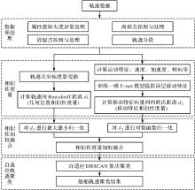
Fig. 1
Overall framework of the proposed method"


Fig. 2
1D U-net model for extracting deep mobility features of trajectories"

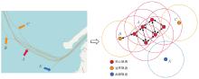
Fig. 3
DBSCAN clustering algorithm for trajectories"


Fig. 4
Experimental data"


Fig. 5
Number distribution of different ship types"


Fig. 6
Results of manual labeling of experimental data"

Tab. 1
Comparison of results for AIS trajectory classification between two models"
| 预测类型 | 真实类型 | 拖船 | 渔船 | 帆船/游艇 | 客船 | 货船 | 精确率 | 召回率 | F1值 |
|---|---|---|---|---|---|---|---|---|---|
| 一维U-net | 拖船 | 160 | 7 | 2 | 1 | 8 | 0.94 | 0.90 | 0.92 |
| 渔船 | 1 | 166 | 28 | 0 | 1 | 0.89 | 0.85 | 0.87 | |
| 帆船/游艇 | 2 | 13 | 196 | 6 | 2 | 0.84 | 0.90 | 0.87 | |
| 客船 | 0 | 0 | 6 | 176 | 2 | 0.92 | 0.96 | 0.94 | |
| 货船 | 7 | 0 | 0 | 8 | 170 | 0.93 | 0.92 | 0.92 | |
| LSTM | 拖船 | 136 | 6 | 14 | 3 | 19 | 0.87 | 0.76 | 0.81 |
| 渔船 | 5 | 151 | 21 | 9 | 10 | 0.87 | 0.77 | 0.82 | |
| 帆船/游艇 | 8 | 15 | 169 | 19 | 8 | 0.76 | 0.77 | 0.77 | |
| 客船 | 1 | 1 | 15 | 160 | 7 | 0.72 | 0.87 | 0.79 | |
| 货船 | 6 | 0 | 2 | 32 | 145 | 0.77 | 0.78 | 0.78 |

Fig. 7
2D visualization of deep mobility features extracted by two models"

Fig. 8
F1 scores of clustering results corresponding to different mobility feature similarity distance weights k2"
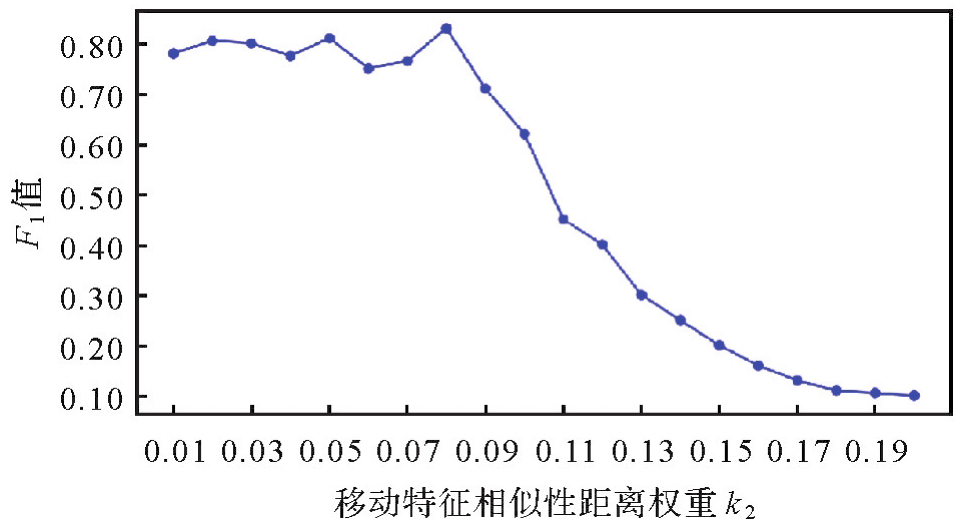

Fig. 9
Clustering results of local trajectories under three different k2 values"


Fig. 10
Clustering results of ship trajectories considering geometric position and mobility feature similarity (dataset Ⅰ)"

Tab. 2
Performance comparison of different clustering algorithms"
| 船舶轨迹聚类方法 | 轮廓系数 | DBI指数 | 噪声率/(%) |
|---|---|---|---|
| 基于Hausdorff距离的密度聚类方法 | 0.811 | 0.927 | 3.09 |
| 基于LCSS距离的密度聚类方法 | 0.801 | 0.915 | 4.45 |
| MD-DBSCAN | 0.792 | 0.965 | 7.45 |
| 顾及几何位置和移动特征相似性的聚类方法 | 0.815 | 0.876 | 4.63 |
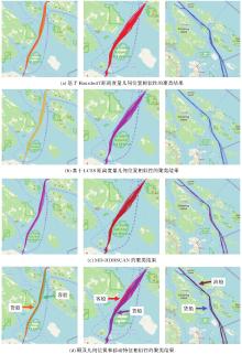
Fig. 11
Results comparison of four clustering methods (part trajectories of dataset Ⅰ)"

Tab. 3
Parameter settings and clustering results of two clustering methods"
| 船舶轨迹聚类方法 | 相似性度量 | 自适应确定DBSCAN聚类参数 | 聚类簇数 | 噪声率/(%) | |
|---|---|---|---|---|---|
| 几何位置 | 移动特征 | ||||
| 基于Hausdorff距离度量几何位置相似性的聚类方法 | k1=1 | k2=0 | ε=0.069 | 10 | 2.1 |
| MinLns=5 | |||||
| 顾及几何位置和移动特征相似性的聚类方法 | k1=0.92 | k2=0.08 | ε=0.059 | 26 | 6.2 |
| MinLns=3 | |||||
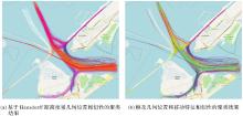
Fig. 12
Comparison of clustering results based on Hausdorff distance and clustering results considering geometric position and mobility features (dataset Ⅱ)"

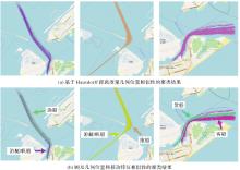
Fig. 13
Comparison of clustering results based on Hausdorff distance and clustering result considering geometric position and mobility features (Part trajectories of dataset)"

| [1] |
刘海砚, 郭漩, 刘俊楠. 时空和语义结合的船舶轨迹数据压缩方法[J]. 测绘学报, 2023, 52(11): 1974-1982. DOI: .
doi: 10.11947/j.AGCS.2023.20210658 |
|
LIU Haiyan, GUO Xuan, LIU Junnan. A vessel trajectory data compression method combining spatio-temporal and semantic features[J]. Acta Geodaetica et Cartographica Sinica, 2023, 52(11): 1974-1982. DOI: .
doi: 10.11947/j.AGCS.2023.20210658 |
|
| [2] | GUHA S, RASTOGI R, SHIM K. Cure: an efficient clustering algorithm for large databases[J]. Information Systems, 2001, 26(1): 35-58. |
| [3] | PALLOTTA G, VESPE M, BRYAN K. Vessel pattern knowledge discovery from AIS data: a framework for anomaly detection and route prediction[J]. Entropy, 2013, 15(6): 2218-2245. |
| [4] | ZHANG Rui, WU Hanyue, YIN Zhenzhong, et al. Predictive clustering of vessel behavior based on hierarchical trajectory representation[J]. IEEE Transactions on Intelligent Transportation Systems, 2024, 25(12): 19496-19506. |
| [5] | JIANG Yan, LI Bo, ZHANG Hao, et al. A novel classification scheme of moving targets at sea based on ward's and K-means clustering[C]//Proceedings of the 2nd International Conference on Computer Science and Application Engineering. Hohhot: ACM Press, 2018: 1-5. |
| [6] | ZHEN Rong, JIN Yongxing, HU Qinyou, et al. Maritime anomaly detection within coastal waters based on vessel trajectory clustering and Naïve Bayes classifier[J]. Journal of Navigation, 2017, 70(3): 648-670. |
| [7] | MA Wenyao, WU Zhaolin, YANG Jiaxuan, et al. Vessel motion pattern recognition based on one-way distance and spectral clustering algorithm[M]//Algorithms and Architectures for Parallel Processing. Cham: Springer International Publishing, 2014: 461-469. |
| [8] | GAO Miao, SHI Guoyou. Ship-handling behavior pattern recognition using AIS sub-trajectory clustering analysis based on the T-SNE and spectral clustering algorithms[J]. Ocean Engineering, 2020, 205: 106919. |
| [9] | ZHAO Liangbin, SHI Guoyou, YANG Jiaxuan. An adaptive hierarchical clustering method for ship trajectory data based on DBSCAN algorithm[C]//Proceedings of 2017 IEEE International Conference on Big Data Analysis. Beijing: IEEE, 2017: 329-336. |
| [10] | ZHAO Liangbin, SHI Guoyou. A trajectory clustering method based on Douglas-Peucker compression and density for marine traffic pattern recognition[J]. Ocean Engineering, 2019, 172: 456-467. |
| [11] | LI Ye, REN Hongxiang. Visual analysis of vessel behaviour based on trajectory data: a case study of the Yangtze River Estuary[J]. ISPRS International Journal of Geo-Information, 2022, 11(4): 244. |
| [12] | WANG Lianhui, CHEN Pengfei, CHEN Linying, et al. Ship AIS trajectory clustering: an HDBSCAN-based approach[J]. Journal of Marine Science and Engineering, 2021, 9(6): 566. |
| [13] | 甄荣, 石自强. 一种基于高斯混合模型的船舶航迹聚类方法[J]. 船舶工程, 2021, 43(11): 139-143. |
| ZHEN Rong, SHI Ziqiang. Ship trajectory clustering method based on Gaussian mixture model[J]. Ship Engineering, 2021, 43(11): 139-143. | |
| [14] | YAO Di, ZHANG Chao, ZHU Zhihua, et al. Learning deep representation for trajectory clustering[J]. Expert Systems, 2018, 35(2): e12252. |
| [15] | LIANG Maohan, LIU R W, LI Shichen, et al. An unsupervised learning method with convolutional auto-encoder for vessel trajectory similarity computation[J]. Ocean Engineering, 2021, 225: 108803. |
| [16] | WANG Chao, HUANG Jiahui, WANG Yongheng, et al. A deep spatiotemporal trajectory representation learning framework for clustering[J]. IEEE Transactions on Intelligent Transportation Systems, 2024, 25(7): 7687-7700. |
| [17] | 甄荣, 邵哲平, 潘家财. 基于AIS数据的船舶行为特征挖掘与预测:研究进展与展望[J]. 地球信息科学学报, 2021, 23(12): 2111-2127. |
| ZHEN Rong, SHAO Zheping, PAN Jiacai. Advance in character mining and prediction of ship behavior based on AIS data[J]. Journal of Geo-Information Science, 2021, 23(12): 2111-2127. | |
| [18] | ZHONG Hanyang, SONG Xin, YAN Zhenguo. Vessel sailing patterns analysis from S-AIS data based on K-means clustering algorithm[C]//Proceedings of the 4th International Conference on Big Data Analytics. Suzhou: IEEE, 2019: 10-13. |
| [19] | LIU Lei, ZHANG Yong, HU Yue, et al. A hybrid-clustering model of ship trajectories for maritime traffic patterns analysis in port area[J]. Journal of Marine Science and Engineering, 2022, 10(3): 342. |
| [20] | 安健鹏, 李海霞, 雷亚丽, 等. 基于大数据的船舶活动轨迹规律挖掘方法[J]. 火力与指挥控制, 2024, 49(4): 156-163. |
| AN Jianpeng, LI Haixia, LEI Yali, et al. Mining method of ship activity trajectory pattern based on big data[J]. Fire Control & Command Control, 2024, 49(4): 156-163. | |
| [21] | ZHANG Yuanqiang, MA Yong, LIU Jiao. Ship trajectory segmentation and semisupervised clustering via geospatial background knowledge[J]. Ocean Engineering, 2024, 304: 117872. |
| [22] | 刘海杨, 孟令航, 林仲航, 等. 基于轨迹点聚类的航路发现方法[J]. 计算机应用, 2022, 42(3): 890-894. |
| LIU Haiyang, MENG Linghang, LIN Zhonghang, et al. Route discovery method based on trajectory point clustering[J]. Journal of Computer Applications, 2022, 42(3): 890-894. | |
| [23] | 张鹏鑫, 李连营, 杨敏, 等. 顾及运动行为特征变化的船舶轨迹分类模型[J]. 测绘科学, 2023, 48(5): 25-34. |
| ZHANG Pengxin, LI Lianying, YANG Min, et al. A ship trajectory classification model considering changes in characteristics of motion behavior[J]. Science of Surveying and Mapping, 2023, 48(5): 25-34. | |
| [24] | RONNEBERGER O, FISCHER P, BROX T. U-Net: convolutional networks for biomedical image segmentation[M]//Medical Image Computing and Computer-Assisted Intervention-MICCAI. Cham: Springer International Publishing, 2015: 234-241. |
| [25] | 李文杰, 闫世强, 蒋莹, 等. 自适应确定DBSCAN算法参数的算法研究[J]. 计算机工程与应用, 2019, 55(5): 1-7, 148. |
| LI Wenjie, YAN Shiqiang, JIANG Ying, et al. Research on method of self-adaptive determination of DBSCAN algorithm parameters[J]. Computer Engineering and Applications, 2019, 55(5): 1-7, 148. | |
| [26] | WANG Lianhui, CHEN Pengfei, CHEN Linying, et al. Ship AIS trajectory clustering: an HDBSCAN-based approach[J]. Journal of Marine Science and Engineering, 2021, 9(6): 566. |
| [27] | 万佳, 胡大裟, 蒋玉明. 多密度自适应确定DBSCAN算法参数的算法研究[J]. 计算机工程与应用, 2022, 58(2): 78-85. |
| WAN Jia, HU Dasha, JIANG Yuming. Research on method of multi-density self-adaptive determination of DBSCAN algorithm parameters[J]. Computer Engineering and Applications, 2022, 58(2): 78-85. | |
| [28] | ROUSSEEUW P J. Silhouettes: a graphical aid to the interpretation and validation of cluster analysis[J]. Journal of Computational and Applied Mathematics, 1987, 20: 53-65. |
| [29] | DAVIES D L, BOULDIN D W. A cluster separation measure[J]. IEEE Transactions on Pattern Analysis and Machine Intelligence, 1979, 1(2): 224-227. |
| [1] | Jiayao WANG, Lin CHEN, Shiyuan CHENG, Lijun WANG, Siqi XIONG. Artificial intelligence empowering the digital-intelligent transformation of cartographic science [J]. Acta Geodaetica et Cartographica Sinica, 2026, 55(3): 381-389. |
| [2] | Xiaomin LU, Zhiyi ZHANG, Haowen YAN, Yi HE, Xiaoning SU. A recognition method for building group pattern integrating deep graph infomax and multilayer perceptron [J]. Acta Geodaetica et Cartographica Sinica, 2026, 55(3): 425-438. |
| [3] | Shunping JI, Jin LIU, Jian GAO, Jianya GONG. An intelligent 3D reconstruction framework via deep learning based multi-view image matching [J]. Acta Geodaetica et Cartographica Sinica, 2025, 54(9): 1633-1646. |
| [4] | Jixian ZHANG, Haiyan GU, Huan NI, Haitao LI, Yi YANG, Shaopeng DING, Songman SUI. Deep learning methods for remote sensing intelligent change detection: evolution and development [J]. Acta Geodaetica et Cartographica Sinica, 2025, 54(8): 1347-1370. |
| [5] | Shuai FANG, Jiaen LIU, Jing ZHANG. Spatio-temporal fusion algorithm based on adaptive reference feature incorporation and multi-scale feature aggregation [J]. Acta Geodaetica et Cartographica Sinica, 2025, 54(8): 1476-1488. |
| [6] | Nina MENG, Fengmei LI, Xiaodong ZHOU. Data and cognition dual-driven building group generalization results and scale consistency assessment [J]. Acta Geodaetica et Cartographica Sinica, 2025, 54(7): 1318-1331. |
| [7] | Yaqing WANG, Zhonghui WANG. River network automated selection method based on heterogeneous graph convolutional networks [J]. Acta Geodaetica et Cartographica Sinica, 2025, 54(7): 1332-1345. |
| [8] | Chao WANG, Tianyu CHEN, Tong ZHANG, Tanvir AHMED, Liqiang JI, Tao XIE, Jiajun YANG, Shuai WANG. Multi-sensor optical remote sensing images change detection based on global differential enhancement module and balance penalty loss [J]. Acta Geodaetica et Cartographica Sinica, 2025, 54(5): 873-887. |
| [9] | Qingli LUO, Xueyan LI, Guoman HUANG, Honghui CHEN, Minglong XUE, Jian LI. AOSN: alpha optimal structure network for height estimation from a single SAR image in mountain areas [J]. Acta Geodaetica et Cartographica Sinica, 2025, 54(5): 888-898. |
| [10] | Wei TU, Xiangyuan CHI, Tianhong ZHAO, Jian YANG, Shiping ZHU, Deli CHEN. Multi-view spatio-temporal graph convolutional networks model for urban drainage networks flow prediction [J]. Acta Geodaetica et Cartographica Sinica, 2025, 54(2): 334-344. |
| [11] | Zhili ZHANG, Huiwei JIANG, Xiangyun HU. A minimal-interaction framework for accurate and batch extraction of geospatial objects from remote sensing imagery [J]. Acta Geodaetica et Cartographica Sinica, 2025, 54(10): 1863-1876. |
| [12] | Zhenghua ZHANG, Guoliang CHEN. A lightweight rotation-invariant network for LiDAR-based place recognition [J]. Acta Geodaetica et Cartographica Sinica, 2025, 54(1): 90-103. |
| [13] | Yan SHI, Da WANG, Min DENG, Xuexi YANG. Spatio-temporal anomaly detection: connotation transformation and implementation path from data-driven to knowledge-driven modeling [J]. Acta Geodaetica et Cartographica Sinica, 2024, 53(8): 1493-1504. |
| [14] | Xin YAN, Li SHEN, Junjie PAN, Yanshuai DAI, Jicheng WANG, Xiaoli ZHENG, Zhi-lin LI. Weakly supervised building change detection integrating multi-scale feature fusion and spatial refinement for high resolution remote sensing images [J]. Acta Geodaetica et Cartographica Sinica, 2024, 53(8): 1586-1597. |
| [15] | Jinwei BU, Kegen YU, Qiulan WANG, Linghui LI, Xinyu LIU, Xiaoqing ZUO, Jun CHANG. Deep learning retrieval method for global ocean significant wave height by integrating spaceborne GNSS-R data and multivariable parameters [J]. Acta Geodaetica et Cartographica Sinica, 2024, 53(7): 1321-1335. |
| Viewed | ||||||
|
Full text |
|
|||||
|
Abstract |
|
|||||