

Acta Geodaetica et Cartographica Sinica ›› 2025, Vol. 54 ›› Issue (9): 1677-1686.doi: 10.11947/j.AGCS.2025.20240497
• Photogrammetry and Remote Sensing • Previous Articles Next Articles
Weitong WU1( ), Chi CHEN2(), Bisheng YANG2, Xiufeng HE1
Received:2024-12-09
Revised:2025-07-09
Online:2025-10-10
Published:2025-10-10
Contact:
Chi CHEN
E-mail:weitongwu@hhu.edu.cn;chichen@whu.edu.cn
About author:WU Weitong (1995—), male, PhD, assistant researcher, majors in multi-sensor fusion SLAM. E-mail: weitongwu@hhu.edu.cn
Supported by:CLC Number:
Weitong WU, Chi CHEN, Bisheng YANG, Xiufeng HE. Robust multi-sensor fusion-based odometry method of LiDAR, millimeter-wave radar and IMU in degraded scenes[J]. Acta Geodaetica et Cartographica Sinica, 2025, 54(9): 1677-1686.

Fig. 1
The workflow of multi-sensor-based robust odometry"

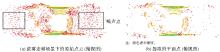
Fig. 2
Planar LiDAR points extraction"


Fig. 3
Comparison of TI millimeter-wave radar point cloud (red) and LiDAR point cloud (blue)"

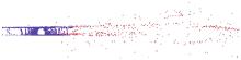
Fig. 4
Comparison of Conti ARS548 millimeter-wave radar point cloud (red) and LiDAR point cloud (blue) (top view)"

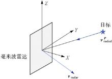
Fig. 5
The radial velocity measurement of millimeter-wave radar"

Tab. 1
LiDAR sensor specifications"
| 基础参数 | Ouster OS0-128 | Hesai XT32 |
|---|---|---|
| 激光波长/nm | 865 | 905 |
| 最大测距/m | 50 | 120 |
| 测距精度/cm | ±3 | ±2 |
| 视场角/(°) | 竖直:90 | 竖直:31 |
| 水平:360 | 水平:360 | |
| 竖直角度分辨率/(°) | 0.7 | 1 |
Tab. 2
Millimeter-wave radar sensor specifications"
| 基础参数 | TI IWR6843AOP-EVM | Conti ARS548 |
|---|---|---|
| 起始波长/mm | 5 | 3.9 |
| 最大测距/m | 16 | 300 |
| 测距分辨率/cm | 7.85 | 22 |
| 速度分辨率/(m/s) | 0.133 | 0.097 |
| 竖直/水平角度分辨率/(°) | 29 | 2.3/1.2 |
Tab. 3
Dataset description"
| 数据集 | 特点 | 轨迹长度/m | 数据时长/s |
|---|---|---|---|
| 自行车隧道 | 前进方向几何特征少 | 约500 | 324 |
| 走廊 | 有浓雾,感知受限 | 约100 | 173 |
| 公路隧道 | 有少量前进方向特征 | 约1000 | 107 |
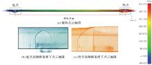
Fig. 6
Experimental results of point clouds for bicycle tunnel dataset"

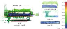
Fig. 7
Experimental results of corridor dataset"

Tab. 4
Closure error on corridor dataset"
| 对比方法 | 闭合差/m | 闭合差与轨迹长度比/(%) |
|---|---|---|
| 本文方法 | 0.94 | 0.90 |
| FAST-LIO2 | 失败 | 失败 |
| EKF-RIO | 4.80 | 4.60 |
| 本文方法(不包含LiDAR) | 4.71 | 4.50 |
| 本文方法(直接融合) | 12.42 | 11.86 |
Tab. 5
Absolute trajectory error (ATE) results for highway tunnel data"
| 对比方法 | 均方根误差/m | 最大误差/m |
|---|---|---|
| 本文方法 | 4.57 | 10.88 |
| FAST-LIO2 | 4.78 | 10.00 |
| EKF-RIO | 失败 | 失败 |
| 本文方法(不包含LiDAR) | 失败 | 失败 |
| 本文方法(直接融合) | 6.01 | 13.87 |
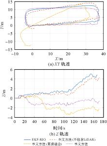
Fig. 8
Experimental results of trajectories for corridor dataset"

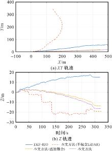
Fig. 9
Experimental results of trajectories for bicycle tunnel dataset"
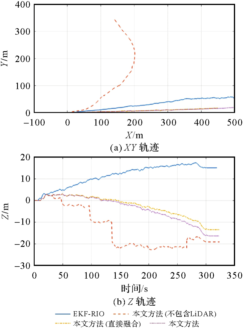
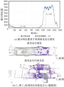
Fig. 10
LiDAR degeneracy detection results for corridor dataset"

| [1] |
李德仁. 展望5G/6G时代的地球空间信息技术[J]. 测绘学报, 2019, 48(12): 1475-1481. DOI: .
doi: 10.11947/j.AGCS.2019.20190437 |
|
LI Deren. Towards geospatial information technology in 5G/6G era[J]. Acta Geodaetica et Cartographica Sinica, 2019, 48(12): 1475-1481. DOI: .
doi: 10.11947/j.AGCS.2019.20190437 |
|
| [2] |
李清泉, 张德津, 汪驰升, 等. 动态精密工程测量技术及应用[J]. 测绘学报, 2021, 50(9): 1147-1158. DOI: .
doi: 10.11947/j.AGCS.2021.20210172 |
|
LI Qingquan, ZHANG Dejin, WANG Chisheng, et al. Technology and applications of dynamic and precise engineering surveying[J]. Acta Geodaetica et Cartographica Sinica, 2021, 50(9): 1147-1158. DOI: .
doi: 10.11947/j.AGCS.2021.20210172 |
|
| [3] | CADENA C, CARLONE L, CARRILLO H, et al. Past, present, and future of simultaneous localization and mapping: toward the robust-perception age[J]. IEEE Transactions on Robotics, 2016, 32(6): 1309-1332. |
| [4] |
邸凯昌, 万文辉, 赵红颖, 等. 视觉SLAM技术的进展与应用[J]. 测绘学报, 2018, 47(6): 770-779. DOI: .
doi: 10.11947/j.AGCS.2018.20170652 |
|
DI Kaichang, WAN Wenhui, ZHAO Hongying, et al. Progress and applications of visual SLAM[J]. Acta Geodaetica et Cartographica Sinica, 2018, 47(6): 770-779. DOI: .
doi: 10.11947/j.AGCS.2018.20170652 |
|
| [5] | 王金科, 左星星, 赵祥瑞, 等. 多源融合SLAM的现状与挑战[J]. 中国图象图形学报, 2022, 27(2): 368-389. |
| WANG Jinke, ZUO Xingxing, ZHAO Xiangrui, et al. Review of multi-source fusion SLAM: current status and challenges[J]. Journal of Image and Graphics, 2022, 27(2): 368-389. | |
| [6] |
LI Xingxing, ZHANG Xiaohong, NIU Xiaoji, et al. Progress and achievements of multi-sensor fusion navigation in China during 2019—2023[J]. Journal of Geodesy and Geoinformation Science, 2023, 6(3): 102-114. DOI:
doi: 10.11947/j.JGGS.2023.0310 |
| [7] | 李健平, 杨必胜. 头盔式激光扫描系统WHU-Helmet[J]. 同济大学学报(自然科学版), 2022, 50(7): 933-939. |
| LI Jianping, YANG Bisheng. A Helmet-based laser scanning system for 3D dynamic mapping[J]. Journal of Tongji University (Natural Science), 2022, 50(7): 933-939. | |
| [8] | ZHANG Ji, SINGH S. LOAM: LiDAR odometry and mapping in real-time[EB/OL]. [2024-10-10]. https://www.roboticsproceedings.org/rss10/p07.pdf. |
| [9] | SHAN Tixiao, ENGLOT B. Lego-loam: lightweight and ground-optimized LiDAR odometry and mapping on variable terrain[C]//Proceedings of 2018 IEEE/RSJ International Conference on Intelligent Robots and Systems. Madrid: IEEE, 2018: 4758-4765. |
| [10] | PAN Yue, XIAO Pengchuan, HE Yujie, et al. MULLS: versatile LiDAR SLAM via multi-metric linear least square[C]//Proceedings of 2021 IEEE International Conference on Robotics and Automation. Xi'an: IEEE, 2021: 11633-11640. |
| [11] | CHEN K, LOPEZ B T, AGHA-MOHAMMADI A, et al. Direct LiDAR odometry: fast localization with dense point clouds[J]. IEEE Robotics and Automation Letters, 2022, 7(2): 2000-2007. |
| [12] | ZHAO Shibo, GAO Yuanjun, WU Tianhao, et al. SubT-MRS dataset: pushing SLAM towards all-weather environments[C]//Proceedings of 2024 IEEE/CVF Conference on Computer Vision and Pattern Recognition. Seattle: IEEE, 2024: 22647-22657. |
| [13] | YE Haoyang, CHEN Yuying, LIU Ming. Tightly coupled 3D LiDAR inertial odometry and mapping[C]//Proceedings of 2019 International Conference on Robotics and Automation. Montreal: IEEE, 2019: 3144-3150. |
| [14] |
王铉彬, 李星星, 廖健驰, 等. 基于图优化的紧耦合双目视觉/惯性/激光雷达SLAM方法[J]. 测绘学报, 2022, 51(8): 1744-1756. DOI: .
doi: 10.11947/j.AGCS.2022.20210503 |
|
WANG Xuanbin, LI Xingxing, LIAO Jianchi, et al. Tightly-coupled stereo visual-inertial-LiDAR SLAM based on graph optimization[J]. Acta Geodaetica et Cartographica Sinica, 2022, 51(8): 1744-1756. DOI: .
doi: 10.11947/j.AGCS.2022.20210503 |
|
| [15] | ALMALIOGLU Y, TURAN M, LU C X, et al. Milli-RIO: ego-motion estimation with low-cost millimetre-wave radar[J]. IEEE Sensors Journal, 2021, 21(3): 3314-3323. |
| [16] | 黄岩, 张慧, 兰吕鸿康, 等. 汽车毫米波雷达信号处理技术综述[J]. 雷达学报, 2023, 12(5): 923-970. |
| HUANG Yan, ZHANG Hui, LAN Lühongkang, et al. Overview of signal processing techniques for automotive millimeter-wave radar[J]. Journal of Radars, 2023, 12(5): 923-970. | |
| [17] | QIN Chao, YE Haoyang, PRANATA C E, et al. Lins: a LiDAR-inertial state estimator for robust and efficient navigation[C]//Proceedings of 2020 IEEE International Conference on Robotics and Automation. Paris: IEEE, 2020: 8899-8906. |
| [18] | XU Wei, ZHANG Fu. Fast-lio: a fast, robust LiDAR-inertial odometry package by tightly-coupled iterated Kalman filter[J]. IEEE Robotics and Automation Letters, 2021, 6(2): 3317-3324. |
| [19] | XU Wei, CAI Yixi, HE Dongjiao, et al. FAST-LIO2: fast direct LiDAR-inertial odometry[J]. IEEE Transactions on Robotics, 2022, 38(4): 2053-2073. |
| [20] | ZHENG Chunran, ZHU Qingyan, XU Wei, et al. FAST-LIVO: fast and tightly-coupled sparse-direct LiDAR-inertial-visual odometry[C]//Proceedings of 2022 IEEE/RSJ International Conference on Intelligent Robots and Systems. Kyoto: IEEE, 2022: 4003-4009. |
| [21] | ZHENG Chunran, XU Wei, ZOU Zuhao, et al. FAST-LIVO2: fast, direct LiDAR-inertial-visual odometry[J]. IEEE Transactions on Robotics, 2025, 41: 326-346. |
| [22] | DOER C, TROMMER G F. An EKF based approach to radar inertial odometry[C]//Proceedings of 2020 IEEE International Conference on Multisensor Fusion and Integration for Intelligent Systems. Karlsruhe: IEEE, 2020: 152-159. |
| [23] | ZHUANG Yuan, WANG Binliang, HUAI Jianzhu, et al. 4D iRIOM: 4D imaging radar inertial odometry and mapping[J]. IEEE Robotics and Automation Letters, 2023, 8(6): 3246-3253. |
| [24] | HUANG Qiucan, LIANG Yuchen, QIAO Zhijian, et al. Less is more: physical-enhanced radar-inertial odometry[C]//Proceedings of 2024 IEEE International Conference on Robotics and Automation. Yokohama: IEEE, 2024: 15966-15972. |
| [25] | GIROD R, HAUSWIRTH M, PFREUNDSCHUH P, et al. A robust baro-radar-inertial odometry M-estimator for multicopter navigation in cities and forests[C]//Proceedings of 2024 IEEE International Conference on Multisensor Fusion and Integration for Intelligent Systems. Pilsen: IEEE, 2024: 1-8. |
| [26] | NISSOV M, KHEDEKAR N, ALEXIS K. Degradation resilient LiDAR-radar-inertial odometry[C]//Proceedings of 2024 IEEE International Conference on Robotics and Automation. Yokohama: IEEE, 2024: 8587-8594. |
| [27] | LÜ Jiajun, LANG Xiaolei, XU Jinhong, et al. Continuous-time fixed-lag smoothing for LiDAR-inertial-camera SLAM[J]. IEEE/ASME Transactions on Mechatronics, 2023, 28(4): 2259-2270. |
| [28] | WISTH D, CAMURRI M, DAS S, et al. Unified multi-modal landmark tracking for tightly coupled lidar-visual-inertial odometry[J]. IEEE Robotics and Automation Letters, 2021, 6(2): 1004-1011. |
| [29] | DEMANTKÉ J, MALLET C, DAVID N, et al. Dimensionality based scale selection in 3D LiDAR point clouds[J]. The International Archives of the Photogrammetry, Remote Sensing and Spatial Information Sciences, 2012, 3812: 97-102. |
| [30] | FISCHLER M A, BOLLES R C. Random sample consensus: a paradigm for model fitting with applications to image analysis and automated cartography[J]. Communications of the ACM, 1981, 24(6): 381-395. |
| [31] | SOLA J. Quaternion kinematics for the error-state Kalman filter[EB/OL]. [2024-10-10]. https://arxiv.org/abs/1711.02508. |
| [32] | GELFAND N, IKEMOTO L, RUSINKIEWICZ S, et al. Geometrically stable sampling for the ICP algorithm[C]//Proceedings of the 4th International Conference on 3D Digital Imaging and Modeling. Banff: IEEE, 2003: 260-267. |
| [33] | ZHANG Ji, KAESS M, SINGH S. On degeneracy of optimization-based state estimation problems[C]//Proceedings of 2016 IEEE International Conference on Robotics and Automation. Stockholm: IEEE, 2016: 809-816. |
| [34] | DRAISMA J, OTTAVIANI G, TOCINO A. Best rank-k approximations for tensors: generalizing Eckart-Young[J]. Research in the Mathematical Sciences, 2018, 5(2): 27. |
| [35] | HUAI Jianzhu, WANG Binliang, ZHUANG Yuan, et al. SNAIL-radar: a large-scale diverse dataset for the evaluation of 4D-radar-based SLAM systems[J/OL]. International Journal of Robotics Research. [2024-10-10]. https://journals.sagepub.com/doi/abs/10.1177/02783649251329048. |
| [1] | Siyuan BAI, Hongzhou CHAI, Qing WU, Gen LI, Yuhao YE, Honglei MA. Buoys-aided integrated navigation method for UUV under ice with sea ice drift compensation [J]. Acta Geodaetica et Cartographica Sinica, 2026, 55(4): 698-707. |
| [2] | Lei LIANG, Changqing WANG, Lingyong HUANG, Zhiyong HUANG, Yaoyao YU, Min ZHONG, Yihao YAN, Qinglu MU. GRACE-FO attitude data determination with consideration of star camera alignment matrix calibration [J]. Acta Geodaetica et Cartographica Sinica, 2026, 55(2): 287-300. |
| [3] | Cong SHEN, Guocheng WANG, Lintao LIU, Huiwen HU, Zhiwu CAI. Kalman filter-based satellite clock bias prediction algorithm with frequency difference estimation correction [J]. Acta Geodaetica et Cartographica Sinica, 2025, 54(9): 1596-1607. |
| [4] | Dongdong PU, Hongzhou CHAI, Yongzhong OUYANG, Chao DONG. Hierarchical encryption matching algorithm for adjacent strip splicing in airborne LiDAR bathymetry [J]. Acta Geodaetica et Cartographica Sinica, 2025, 54(8): 1439-1451. |
| [5] | Jie WAN, Zhong XIE, Yongyang XU, Liufeng TAO. A U-shaped graph convolution network method for semantic segmentation of vehicle LiDAR point clouds towards urban road scenes [J]. Acta Geodaetica et Cartographica Sinica, 2025, 54(7): 1280-1293. |
| [6] | Dianpeng SU, Bin WANG, Xiaozheng MAI, Huang MENG, Chao QI, Fanlin YANG. Calibration of placement angle errors of airborne bathymetric LiDAR without field control [J]. Acta Geodaetica et Cartographica Sinica, 2025, 54(6): 1042-1053. |
| [7] | Lianzhong XU, Chuanfa CHEN, Dongxing CHEN, Xingjie WANG, Ziming YANG, Shufan YANG, Zhuangzhuang HONG, Jinda HAO. An efficient filtering method considering terrain features for large-scale airborne LiDAR point clouds [J]. Acta Geodaetica et Cartographica Sinica, 2025, 54(6): 1082-1093. |
| [8] | Haolong GAO, Shaobo LI, Jianhu ZHAO. Multipath negative outlier removal method for coastal LiDAR point clouds based on mirror structure and intensity feature constraints [J]. Acta Geodaetica et Cartographica Sinica, 2025, 54(5): 840-852. |
| [9] | Xing ZHANG, Zhanpeng HUANG, Qingquan LI, Baoding ZHOU, Qipei LI. 3D tunnel mapping method combining registration compensation and spatial constraint [J]. Acta Geodaetica et Cartographica Sinica, 2025, 54(2): 297-307. |
| [10] | Kefan SHAO, Zengke LI, Meng SUN, Zhenbin LIU, Qi WU. A geomagnetic SLAM method enhanced by multi-source data fusion based on smartphones [J]. Acta Geodaetica et Cartographica Sinica, 2025, 54(10): 1812-1825. |
| [11] | Yongjun ZHANG, Changjun ZHU, Siyuan ZOU, Xinyi LIU, Qingzhou MAO, Yi WAN. Registration of aerial images and LiDAR point clouds based on distance field and plane constraints [J]. Acta Geodaetica et Cartographica Sinica, 2025, 54(1): 64-74. |
| [12] | Zhenghua ZHANG, Guoliang CHEN. A lightweight rotation-invariant network for LiDAR-based place recognition [J]. Acta Geodaetica et Cartographica Sinica, 2025, 54(1): 90-103. |
| [13] | Yinzhi ZHAO, Jingui ZOU, Xiaoxi ZHANG, Ze WANG, Xinzhe WANG. An innovative millimeter-level positioning method for multiple millimeter wave radar network in tunnel environment [J]. Acta Geodaetica et Cartographica Sinica, 2024, 53(9): 1679-1693. |
| [14] | Tao XU, Yuanwei YANG, Xianjun GAO, Zhiwei WANG, Yue PAN, Shaohua LI, Lei XU, Yanjun WANG, Bo LIU, Jing YU, Fengmin WU, Haoyu SUN. Integrated graph convolution and multi-scale features for the overhead catenary system point cloud semantic segmentation [J]. Acta Geodaetica et Cartographica Sinica, 2024, 53(8): 1624-1633. |
| [15] | SUN Chuanmeng, WEI Yu, LI Xinyu, MA Tiehua, WU Zhibo. Intelligent detection method of image water level inversion for water level without water scale in complex scenes [J]. Acta Geodaetica et Cartographica Sinica, 2024, 53(3): 558-568. |
| Viewed | ||||||
|
Full text |
|
|||||
|
Abstract |
|
|||||