

Acta Geodaetica et Cartographica Sinica ›› 2025, Vol. 54 ›› Issue (12): 2206-2218.doi: 10.11947/j.AGCS.2025.20250213
• Geodesy and Navigation • Previous Articles Next Articles
Yupeng GU1( ), Wanke LIU1(), Xiaohong ZHANG1,2, Jie HU1, Shujie HU1, Weihao LEI1, Kai ZHENG3
Received:2025-05-26
Revised:2025-11-12
Online:2026-01-15
Published:2026-01-15
Contact:
Wanke LIU
E-mail:ypgu1017@whu.edu.cn;wkliu@sgg.whu.edu.cn
About author:GU Yupeng (2001—), male, postgraduate, majors in navigation techniques and systems. E-mail: ypgu1017@whu.edu.cn
Supported by:CLC Number:
Yupeng GU, Wanke LIU, Xiaohong ZHANG, Jie HU, Shujie HU, Weihao LEI, Kai ZHENG. Neural network-based GNSS stochastic model generation method by fisheye images[J]. Acta Geodaetica et Cartographica Sinica, 2025, 54(12): 2206-2218.
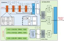
Fig. 1
F-GNet architecture"

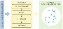
Fig. 2
Process of GNSS feature projection"
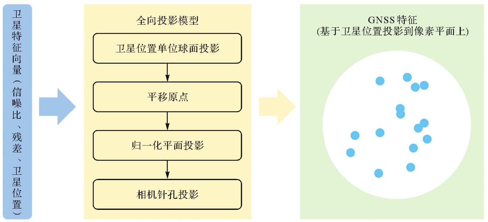
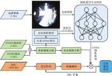
Fig. 3
F-GNet-assisted tightly coupled RTK/IMU navigation system architecture"


Fig. 4
Experimental data acquisition platform"
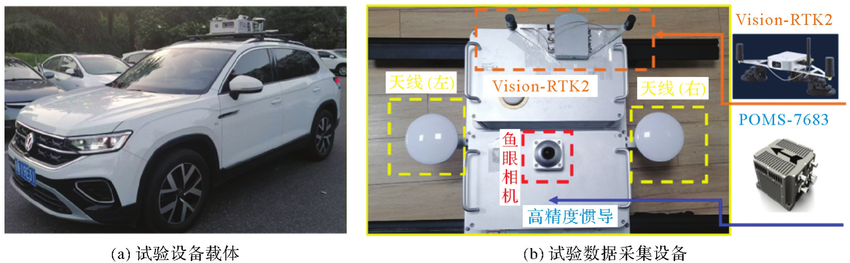
Tab. 1
Experimental sensor parameters"
| 传感器类型 | 传感器说明 | 传感器参数 |
|---|---|---|
| POMS-7683 | 高精度组合导航设备 | 陀螺零偏不稳定性:0.1°/h |
| 数据频率:200 Hz | ||
| ICM-20602 | 低成本IMU | 陀螺零偏不稳定性:10°/h |
| 数据频率:200 Hz | ||
| Ublox F9P | 低成本GNSS接收机 | 卫星系统:G/R/E/C/J |
| 数据频率:1 Hz | ||
| 鱼眼相机 | 相机 | 图像分辨率:2048×2048 |
| 数据频率:1 Hz |
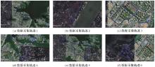
Fig. 5
Experimental data acquisition trajectory"

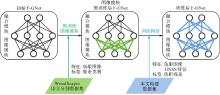
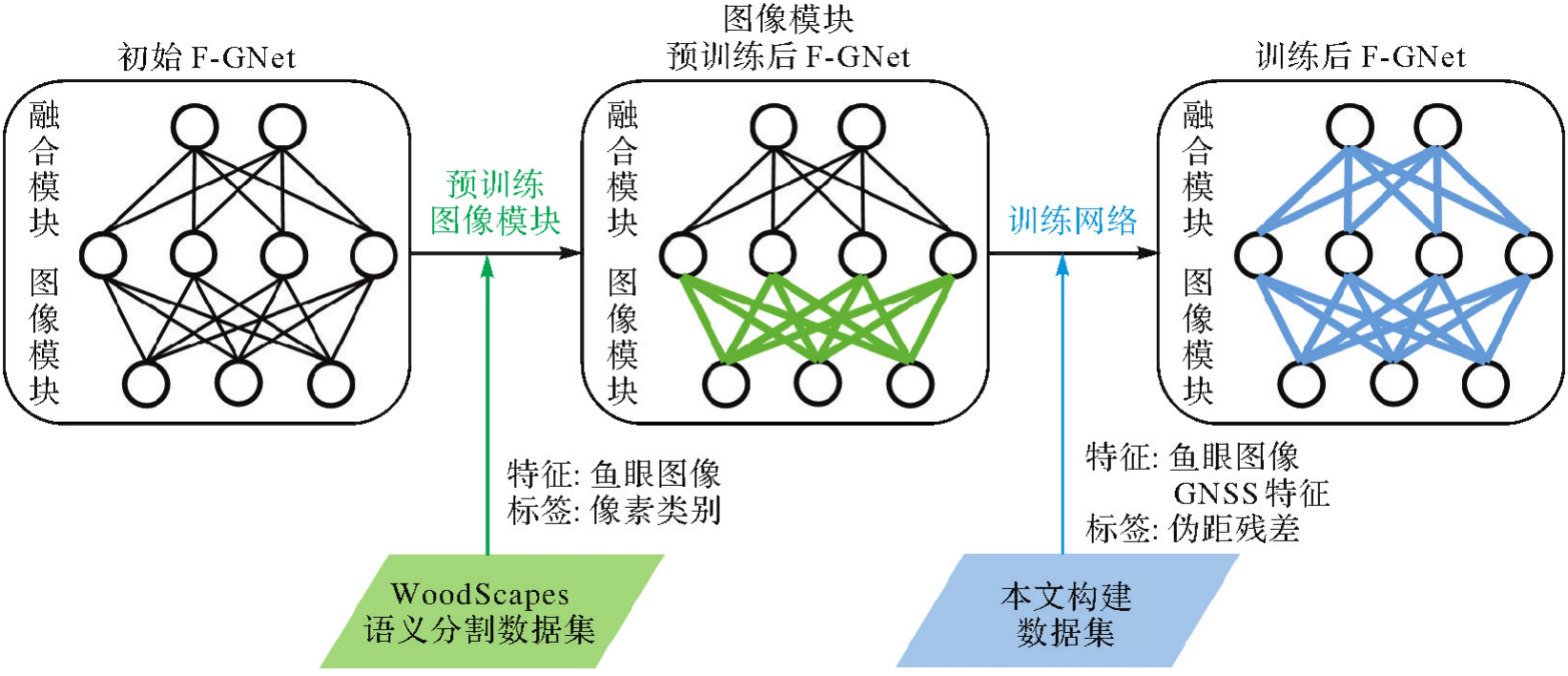
Fig. 6
Process of transfer learning"
Tab. 2
Basic GNSS processing configuration"
| 项目 | 配置 |
|---|---|
| 观测数据 | GPS(L1、L2) |
| BDS-2(B1I、B2I) | |
| BDS-3(B1I) | |
| Galileo(E1、E5) | |
| QZSS(L1、L2) | |
| 星历 | 广播星历 |
| 截止高度角/(°) | 15 |
| 截止信噪比/dBHz | 25 |
Tab. 3
Performance comparison of different network designs"
| 网络设计 | GNSS随机模型RMSE/m |
|---|---|
| GI:图像特征+GNSS特征 | 1.79 |
| CI:交叉注意力层+图像特征 | 3.20 |
| CGI:交叉注意力层+图像特征+GNSS特征 | 1.59 |
Tab. 4
Effect of modality configuration in cross-attention layers on F-GNet performance"
| 网络结构 | GNSS随机模型RMSE/m |
|---|---|
| 模态A | 1.62 |
| 模态B | 1.59 |
| 模态C | 5.52 |
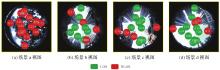
Fig. 7
Sky view image and satellite occlusion view in different typical scenarios"

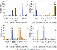
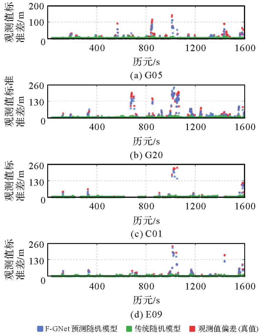
Fig. 8
Prior error based on stochastic model and bias (reference value) of observations in different typical scenarios"
Tab. 5
Error and PDOP of single-point positioning in typical GNSS scenarios"
| 场景 | 定位偏差/m | PDOP | ||||
|---|---|---|---|---|---|---|
| Trad | NLOS-seg | F-GNet | Trad | NLOS-seg | F-GNet | |
| 场景a | 16.935 | N/A | 3.101 | 1.688 | N/A | 1.688 |
| 场景b | 16.082 | 12.425 | 7.227 | 1.792 | 2.471 | 1.792 |
| 场景c | 6.661 | 4.605 | 2.892 | 1.585 | 1.877 | 1.585 |
| 场景d | 6.536 | 3.840 | 2.096 | 1.521 | 1.960 | 1.521 |
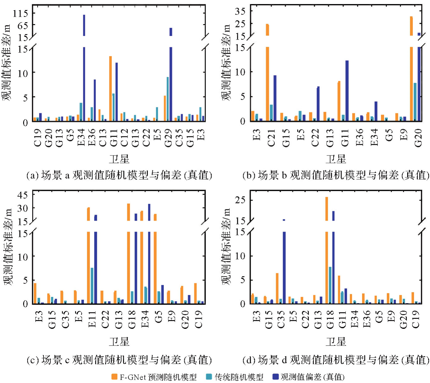
Fig. 9
Time series of prior error based on stochastic model and bias (reference value) of observations"
Tab. 6
GNSS stochastic model predictive accuracy"
| 方法 | GNSS随机模型RMSE/m |
|---|---|
| 传统随机模型 | 10.34 |
| F-GNet | 1.59 |
Tab. 7
F-GNet runtime"
| 最大耗时 | 最小耗时 | 平均耗时 |
|---|---|---|
| 21.1 | 8.8 | 9.2 |
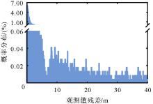
Fig. 10
Double-difference pseudorange residual distribution of GNSS observations"

Fig. 11
Positioning error sequence"
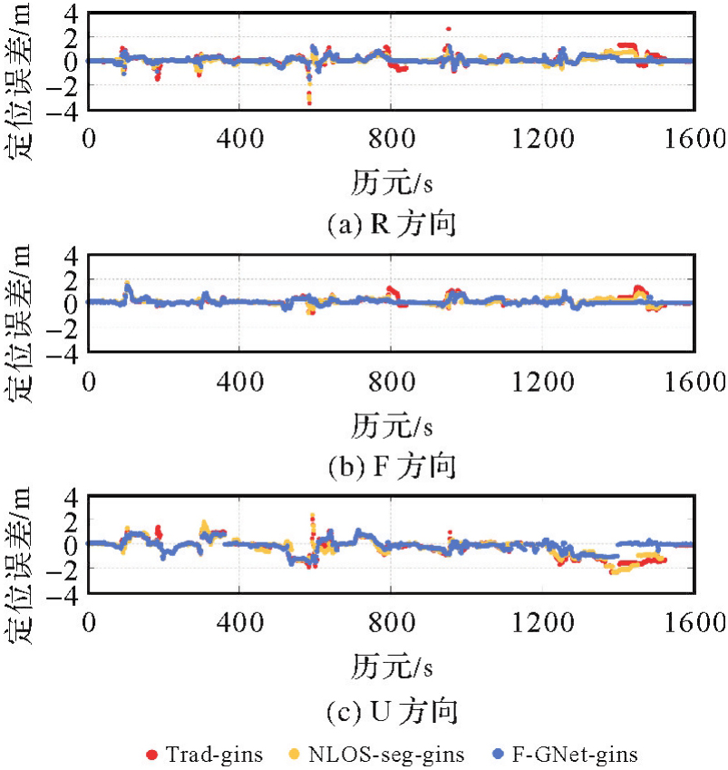
Tab. 8
Positioning accuracy of different solutions"
| 解算方案 | 定位RMSE/m | 提升率/(%) | |||
|---|---|---|---|---|---|
| R | F | U | 3D | ||
| Trad-gins | 0.403 | 0.338 | 0.739 | 0.907 | — |
| NLOS-seg-gins | 0.280 | 0.266 | 0.701 | 0.801 | 11.7 |
| F-GNet-gins | 0.246 | 0.248 | 0.499 | 0.609 | 32.9 |
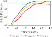
Fig. 12
Cumulative distribution of 3D positioning errors"
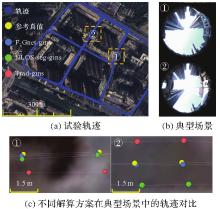
Fig. 13
Comparative trajectory of different solutions"

| [1] |
耿江辉, 常华, 郭将, 等. 面向城市复杂环境的3种多频多系统GNSS单点高精度定位方法及性能分析[J]. 测绘学报, 2020, 49(1): 1-13. DOI: .
doi: 10.11947/j.AGCS.2020.20190106 |
|
GENG Jianghui, CHANG Hua, GUO Jiang, et al. Three multi-frequency and multi-system GNSS high-precision point positioning methods and their performance in complex urban environment[J]. Acta Geodaetica et Cartographica Sinica, 2020, 49(1): 1-13. DOI: .
doi: 10.11947/j.AGCS.2020.20190106 |
|
| [2] | 刘慧娟, 党亚民, 王潜心. 多星座实时导航中一种快速次优的选星方法[J]. 测绘科学, 2013, 38(1): 20-22. |
| LIU Huijuan, DANG Yamin, WANG Qianxin. A fast sub-optimal satellite selection method in multi-constellation real-time navigation[J]. Science of Surveying and Mapping, 2013, 38(1): 20-22. | |
| [3] | 黄观文, 雷哲哲, 王进, 等. 亚太区域不同遮挡情形下多系统组合PPP定位效能分析[J]. 大地测量与地球动力学, 2018, 38(6): 562-567. |
| HUANG Guanwen, LEI Zhezhe, WANG Jin, et al. Efficiency analysis of multi-GNSS combined PPP in complex conditions of Asia-Pacific region[J]. Journal of Geodesy and Geodynamics, 2018, 38(6): 562-567. | |
| [4] | ZHENG Fu, LI Qingcheng, WANG Jiale, et al. GNSS NLOS detection method based on stacking ensemble learning and applications in smartphones[J]. GPS Solutions, 2024, 28(3): 129. |
| [5] | SUN Rui, WANG Guanyu, ZHANG Wenyu, et al. A gradient boosting decision tree based GPS signal reception classification algorithm[J]. Applied Soft Computing, 2020, 86: 105942. |
| [6] | LI Xin, XU Qi, LI Xingxing, et al. Improving PPP-RTK-based vehicle navigation in urban environments via multilayer perceptron-based NLOS signal detection[J]. GPS Solutions, 2023, 28(1): 29. |
| [7] | YOZEVITCH R, BEN MOSHE B, WEISSMAN A. A robust GNSS LOS/NLOS signal classifier[J]. Navigation, 2016, 63(4): 429-442. |
| [8] |
朱彬, 杨诚, 刘岩. GNSS多径信号3种非监督学习法分析与比较[J]. 测绘学报, 2021, 50(12): 1762-1771. DOI: .
doi: 10.11947/j.AGCS.2021.20210233 |
|
ZHU Bin, YANG Cheng, LIU Yan. Analysis and comparison of three unsupervised learning clustering methods for GNSS multipath signals[J]. Acta Geodaetica et Cartographica Sinica, 2021, 50(12): 1762-1771. DOI: .
doi: 10.11947/j.AGCS.2021.20210233 |
|
| [9] | ZHANG Xiaohong, WANG Xinyu, LIU Wanke, et al. A reliable NLOS error identification method based on LightGBM driven by multiple features of GNSS signals[J]. Satellite Navigation, 2024, 5(1): 31. |
| [10] | ZENG Kungan, LI Zhenni, ZHAO Haoli, et al. A spatiotemporal information-driven cross-attention model with sparse representation for GNSS NLOS signal classification[J]. IEEE Internet of Things Journal, 2024, 11(19): 31892-31908. |
| [11] | WANG Lei, GROVES P D, ZIEBART M K. Smartphone shadow matching for better cross-street GNSS positioning in urban environments[J]. Journal of Navigation, 2015, 68(3): 411-433. |
| [12] | NG H F, ZHANG Guohao, HSU L T. Robust GNSS shadow matching for smartphones in urban canyons[J]. IEEE Sensors Journal, 2021, 21(16): 18307-18317. |
| [13] | XIN Shaoming, GENG Jianghui, ZHANG Guohao, et al. 3D-mapping-aided PPP-RTK aiming at deep urban canyons[J]. Journal of Geodesy, 2022, 96: 78. |
| [14] | NG H F, ZHANG G, HSU L T. Range-based 3D mapping aided GNSS with NLOS correction based on skyplot with building boundaries[C]//Proceedings of 2019 ION Pacific PNT Meeting, Honolulu: ION, 2019: 737-751. |
| [15] | ZHANG Liyuan, NG H F, ZHANG Guohao, et al. Ray-tracing correction for GNSS velocity estimation using Doppler frequency: a feasibility analysis[J]. IEEE Transactions on Instrumentation and Measurement, 2024, 73: 1-10. |
| [16] | WEN Weisong, BAI Xiwei, KAN Y C, et al. Tightly coupled GNSS/INS integration via factor graph and aided by fish-eye camera[J]. IEEE Transactions on Vehicular Technology, 2019, 68(11): 10651-10662. |
| [17] | SUZUKI T, KUBO N. N-LOS GNSS signal detection using fisheye camera for vehicle navigation in urban environments[C]//Proceedings of 2014 International Technical Meeting of the Satellite Division of the Institute of Navigation. Tampa: ION, 2014: 1897-1906. |
| [18] | 袁蕾, 张守建, 王景荣, 等. 城市遮挡环境下天空图辅助的GNSS/INS组合导航[J]. 测绘科学, 2023, 48(9): 1-8. |
| YUAN Lei, ZHANG Shoujian, WANG Jingrong, et al. GNSS/INS integrated navigation aided by sky images in urban occlusion environment[J]. Science of Surveying and Mapping, 2023, 48(9): 1-8. | |
| [19] | 田哲铭, 李旭, 胡悦, 等. 城市峡谷下视觉辅助的GNSS/INS多阶段定位方法[J]. 仪器仪表学报, 2024, 45(4): 217-225. |
| TIAN Zheming, LI Xu, HU Yue, et al. Multi-stage localization method based on camera-aided GNSS/INS integration in urban canyon areas[J]. Chinese Journal of Scientific Instrument, 2024, 45(4): 217-225. | |
| [20] | MARAIS J, KAZIM S A, COCHERIL Y, et al. Multipath and NLOS detection based on the combination of CN0 values and a fisheye camera[C]//Proceedings of 2020 European Navigation Conference. Dresden: IEEE, 2020: 1-13. |
| [21] | HU Runzhi, WEN Weisong, HSU L. Fisheye camera aided GNSS NLOS detection and learning-based pseudorange bias correction for intelligent vehicles in urban canyons[C]//Proceedings of 2023 International Conference on Intelligent Transportation Systems. Bilbao: IEEE, 2023: 6088-6095. |
| [22] | XIE Enze, WANG Wenhai, YU Zhiding, et al. SegFormer: simple and efficient design for semantic segmentation with Transformers[C]//Proceedings of the 35th International Conference on Neural Information Processing Systems. Red Hook: Curran Associates Inc., 2021. |
| [23] | SCARAMUZZA D. Omnidirectional camera[M]//IKEUCHI K. Computer vision: a reference guide. Cham: Springer International Publishing, 2021: 900-909. |
| [24] | OTH L, FURGALE P, KNEIP L, et al. Rolling shutter camera calibration[C]//Proceedings of 2013 IEEE Conference on Computer Vision and Pattern Recognition. Portland: IEEE, 2013: 1360-1367. |
| [25] | 蔡亲青, 朱锋, 陈曦, 等. 高度角与信噪比混合的GNSS随机模型精化及其对RTK定位性能的影响[J]. 全球定位系统, 2023, 48(1): 24-31. |
| CAI Qinqing, ZHU Feng, CHEN Xi, et al. Refinement of GNSS stochastic model combining elevation angle and SNR and its effect on RTK positioning performance[J]. GNSS World of China, 2023, 48(1): 24-31. | |
| [26] | 张小红, 陶贤露, 王颖喆, 等. 城市场景智能手机GNSS/MEMS融合车载高精度定位[J]. 武汉大学学报(信息科学版), 2022, 47(10): 1740-1749. |
| ZHANG Xiaohong, TAO Xianlu, WANG Yingzhe, et al. MEMS-enhanced smartphone GNSS high-precision positioning for vehicular navigation in urban conditions[J]. Geomatics and Information Science of Wuhan University, 2022, 47(10): 1740-1749. | |
| [27] | RAMACHANDRAN S, SISTU G, MCDONALD J, et al. Woodscape fisheye semantic segmentation for autonomous driving—CVPR 2021 OmniCV Workshop Challenge[EB/OL]. [2025-04-05]. https://arxiv.org/pdf/2107.08246. |
| [28] | KIRILLOV A, MINTUN E, RAVI N, et al. Segment anything[C]//Proceedings of 2023 IEEE/CVF International Conference on Computer Vision. Paris: IEEE, 2023: 3992-4003. |
| [1] | Zhuang SUN, Po LIU, Liang ZHAI, Yu HE, Zutao ZHANG. A self-supervised matching method for polygonal geographic entity based on a three-branch attention network [J]. Acta Geodaetica et Cartographica Sinica, 2026, 55(1): 169-180. |
| [2] | Qing CHENG, Boxuan WANG, Hongyan ZHANG. DRformer: a progressive coupled multiscale CNN and condensed attention Transformer method for hyperspectral image super-resolution [J]. Acta Geodaetica et Cartographica Sinica, 2025, 54(7): 1230-1242. |
| [3] | Yiming ZHAO, Kelin HU, Kelong TU, Yaxian QING, Chao YANG, Kunlun QI, Huayi WU. Multi-label scene classification method based on fusion of SAR and optical remote sensing images [J]. Acta Geodaetica et Cartographica Sinica, 2025, 54(5): 911-923. |
| [4] | Xiong PAN, Zixuan ZHAO, Chang PING, Lihong JIN, Lilong LIU. Ionospheric TEC prediction incorporating semi-parametric and rule-learning [J]. Acta Geodaetica et Cartographica Sinica, 2025, 54(10): 1741-1756. |
| [5] | Yanjun WANG, Xuchao TANG, Cheng WANG, Hengfan CAI. Urban and rural road surface extraction network based on road topological correlation features [J]. Acta Geodaetica et Cartographica Sinica, 2025, 54(1): 75-89. |
| [6] | Jichao LÜ, Rui ZHANG, Xu HE, Ruikai HONG, Age SHAMA, Guoxiang LIU. Multi-branch network assessment and dynamic change analysis of wide-area landslide susceptibility [J]. Acta Geodaetica et Cartographica Sinica, 2025, 54(1): 104-122. |
| [7] | Jiayi TANG, Xiaochong TONG, Chunping QIU, Yaxian LEI, Yi LEI, Haoshuai SONG. Remote sensing scene retrieval method based on scene graph [J]. Acta Geodaetica et Cartographica Sinica, 2025, 54(1): 123-135. |
| [8] | Liangxiong GONG, Xinghua LI, Yuanming CHENG, Xingyou ZHAO, Renping XIE, Honggen WANG. A lightweight remote sensing images change detection network utilizing spatio-temporal difference enhancement and adaptive feature fusion [J]. Acta Geodaetica et Cartographica Sinica, 2025, 54(1): 136-153. |
| [9] | Tao XU, Yuanwei YANG, Xianjun GAO, Zhiwei WANG, Yue PAN, Shaohua LI, Lei XU, Yanjun WANG, Bo LIU, Jing YU, Fengmin WU, Haoyu SUN. Integrated graph convolution and multi-scale features for the overhead catenary system point cloud semantic segmentation [J]. Acta Geodaetica et Cartographica Sinica, 2024, 53(8): 1624-1633. |
| [10] | Liming JIANG, Yi SHAO, Zhiwei ZHOU, Peifeng MA, Teng WANG. A review of intelligent InSAR data processing: recent advancements, challenges and prospects [J]. Acta Geodaetica et Cartographica Sinica, 2024, 53(6): 1037-1056. |
| [11] | Yanan JIANG, Linfeng ZHENG, Qiang XU, Minggao TANG, Xing ZHU. Step-like displacement prediction of landslides guided by deformation mechanism [J]. Acta Geodaetica et Cartographica Sinica, 2024, 53(6): 1128-1139. |
| [12] | Bo KONG, Tinghua AI, Min YANG, Hao WU, Huafei YU, Tianyuan XIAO. Identification of loess landform types jointly affected by contour morphological knowledge and the graph neural network [J]. Acta Geodaetica et Cartographica Sinica, 2024, 53(6): 1154-1164. |
| [13] | Daifeng PENG, Chenchen ZHAI, Dingwei ZHOU, Yongjun ZHANG, Haiyan GUAN, Yufu ZANG. High-resolution optical images change detection based on global information enhancement by pyramid semantic token [J]. Acta Geodaetica et Cartographica Sinica, 2024, 53(6): 1195-1211. |
| [14] | Shaopeng DING, Xiushan LU, Rufei LIU, Yi YANG, Haiyan GU, Haitao LI. Building change detection method combining object feature guidance and multiple attention mechanism [J]. Acta Geodaetica et Cartographica Sinica, 2024, 53(6): 1224-1235. |
| [15] | Changqi JI, Zhaojie GUO, Haili SUN, Ruofei ZHONG. Location and rapid detection method of water leakage in subway tunnels based on mobile laser scanning [J]. Acta Geodaetica et Cartographica Sinica, 2024, 53(6): 1236-1250. |
| Viewed | ||||||
|
Full text |
|
|||||
|
Abstract |
|
|||||